3-13-05
It isn't often I have the opportunity to do a totally
new hike close to Seattle. When I saw this Mountaineer hike coming up I knew
I had to go. The description listing 16 miles with 3000' of gain and some
off trail bushwhacking made it more appealing. Thankfully, the leader had
done this trip previously. Using a map and an old copy of Footsore 2 I was
able to come up with a rough approximation of the route we were to take.
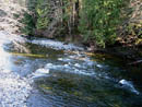
We arrived at the Spur 10 gate on the North Fork Snoqualmie River Road at
8:30 AM. The elevation is just about 1000'. I have been up the road and over
to Lake Calligan but nowhere else. It was clear and a little cold as we headed
out. The road drops gently down to the Snoqualmie River and crosses on a
bridge. A short way ahead is a four way intersection at the 1 1/2 mile mark.
Straight ahead goes to Lake Hancock. This would be our return route. We turned
right and proceeded to the south.
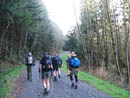
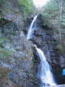
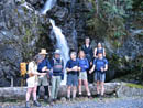
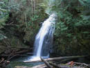
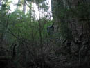
The road was totally flat for 1 1/4 miles before finally beginning to climb. At about 1500' we passed a nice waterfall. It actually takes two consecutive plunges. At about 1800' the fun began. We turned off right on an old and long abandoned road. It was filled with small trees and salmonberry bushes. The leaves and flowers were just beginning to bud so at least it was still easy to see through them. There are numerous trees down along the road but none were very difficult to get over or around. This road stayed level and even began to drop a little. It ended just before Rachor Creek. We dropped down towards the creek.
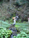
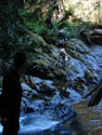
The creek itself is quite something to behold at this point. There is a dark canyon. The creek enters by way of a waterfall into a pool scoured in the rock. On one side is a giant rock wall covered in moss and ferns. A steady breeze blew through as well. We were able to cross the creek with one big step from rock to rock. On the other side it is necessary to scramble steeply up the duff covered hillside. Once above the creek we faced about 300' of steep forest scrambling. We took the path of least resistance as we avoided as many downed logs as possible. Many good sized logs were completely rotted out and would collapse under most any weight. This bit of forest is much different from the clear cuts all around it. The route was steep but mercifully short. We went more or less straight up staying just a short way right of the creek.
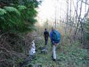
We came out on level ground on another old road. This road is in Footsore 2. It once was a hiking route from North Bend across the Moon Wall to Rachor Vista. Now there is no access at the bottom. We were going to visit an old hiking route by starting at the top. The road was as overgrown as the one we had previously traveled. It descends at a steady grade all the way back to the outskirts of North Bend at an elevation of 500'. It was obvious that virtually nobody has been here in many years. There are a number of places where the hillside has slid making for a little scrambling. Some downed trees were also quite large. Needless to say, our progress was very slow. The Moon Wall is very steep when seen from below. It is amazing that a road was dug out along it.
It was nearing noon when we reached a wide dry creek bed. We could hear rushing water above but it was underground at this point. The many good sized rocks provided a good spot for our group of nine to break for lunch. Moss and licorice ferns covered the banks of the creek bed. Huge mosquitos inhabited this spot as well. Summer in March. After lunch we decided to keep heading on down. We came upon some large rocks either broken off from the cliffs above or deposited by glaciers. Our route ended near 1000' when the route suddenly comes upon a bulldozer in an enclosed canopy. There were no "No Trespassing" signs but it was apparent we had reached someone's property. This was the first time I have hiked for 4 hours to end up in someone's back yard.
We then had to retrace our steps back up the overgrown road. We had broken off a number of overhanging branches on the way down which helped a little on the way up. Slow steady progress was made until we returned to the point where we first reached the road. Just beyond there we again came to Rachor Creek. The remains of the old bridge are still there. Half a dozen huge logs are still there on the other side of the creek. We found it not too difficult to hop rocks and get across. Once across we traversed a short distance to more open slopes and headed straight up. This scramble was very steep but not very long. Within 200' vertical feet we topped out on the gravel logging road we had left many hours ago to begin our adventure.
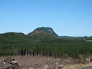
It was now 3:30 and we had two options. We had traveled 8 miles thus far in 7 hours. The easy route would be to follow the road downhill 4 1/2 miles to the cars. That would give us a respectable 12 1/2 miles on the day. The other option was to head uphill and follow the road all the way around to Lake Hancock and out. Being an adventurous group we voted to take the long way. We were at about 2200' and still had another 1000' or more to reach the high point on the road. With the road gated and few people having keys this is very lonesome territory. About a mile along the road we had a great view of the backside of Mt. Teneriffe. I have sat on the summit and looked down into this valley. Now I was actually hiking in it. The road finally turned to the left and began heading north towards Lake Hancock.
There were several spots with very nice views out to Rattlesnake and Tiger Mountains, Seattle and Bellevue, and Fuller Mountain and Klaus Lake below us. It soon became apparent that at our speed and estimating the distance still to go that we were not likely to make it out in daylight. On we trudged as the mile markers kept getting larger and larger. Near the highest point we had one last look at the Puget Sound basin. As the sun dropped the temperature plunged. Sweaters and coats replaced short sleeves. The drop to Hancock was fairly steep for a road as we lost 1000' in less than 2 miles. Near the lake a Jeep passed us. It was the only contact we had with anyone all day. Beyond the lake is an intersection. Right goes to cabins along the shore. Left heads back to our cars. We had first climbed up to the road at the 3 mile marker. At the intersection we reached the 10 mile marker. It was now past 6:30 and getting dark very quickly.
The forest is mostly clear cut below the lake which gave us views out to the lights of North Bend, Snoqualmie Ridge, and the big cities to the west. The last 3 miles were entirely in the dark. We finally came back through the gate to our cars at 8:00 PM. Once home I consulted the map and determined that we had traveled 19 miles with 4000' gained in 11 1/2 hours. Many of those hours were scrambling and bushwhacking at a very slow pace. This turned out to be a fun trip. Every step was new to me and some of it has seen very few people in the last 30 years. We had a strong group and everyone still looked good at the end of a long and grueling day. All in all it was an excellent adventure.
Click on thumbnails to get larger pictures.
Photo Page 2
Trips - 2005
Home
The road was totally flat for 1 1/4 miles before finally beginning to climb. At about 1500' we passed a nice waterfall. It actually takes two consecutive plunges. At about 1800' the fun began. We turned off right on an old and long abandoned road. It was filled with small trees and salmonberry bushes. The leaves and flowers were just beginning to bud so at least it was still easy to see through them. There are numerous trees down along the road but none were very difficult to get over or around. This road stayed level and even began to drop a little. It ended just before Rachor Creek. We dropped down towards the creek.
The creek itself is quite something to behold at this point. There is a dark canyon. The creek enters by way of a waterfall into a pool scoured in the rock. On one side is a giant rock wall covered in moss and ferns. A steady breeze blew through as well. We were able to cross the creek with one big step from rock to rock. On the other side it is necessary to scramble steeply up the duff covered hillside. Once above the creek we faced about 300' of steep forest scrambling. We took the path of least resistance as we avoided as many downed logs as possible. Many good sized logs were completely rotted out and would collapse under most any weight. This bit of forest is much different from the clear cuts all around it. The route was steep but mercifully short. We went more or less straight up staying just a short way right of the creek.
We came out on level ground on another old road. This road is in Footsore 2. It once was a hiking route from North Bend across the Moon Wall to Rachor Vista. Now there is no access at the bottom. We were going to visit an old hiking route by starting at the top. The road was as overgrown as the one we had previously traveled. It descends at a steady grade all the way back to the outskirts of North Bend at an elevation of 500'. It was obvious that virtually nobody has been here in many years. There are a number of places where the hillside has slid making for a little scrambling. Some downed trees were also quite large. Needless to say, our progress was very slow. The Moon Wall is very steep when seen from below. It is amazing that a road was dug out along it.
It was nearing noon when we reached a wide dry creek bed. We could hear rushing water above but it was underground at this point. The many good sized rocks provided a good spot for our group of nine to break for lunch. Moss and licorice ferns covered the banks of the creek bed. Huge mosquitos inhabited this spot as well. Summer in March. After lunch we decided to keep heading on down. We came upon some large rocks either broken off from the cliffs above or deposited by glaciers. Our route ended near 1000' when the route suddenly comes upon a bulldozer in an enclosed canopy. There were no "No Trespassing" signs but it was apparent we had reached someone's property. This was the first time I have hiked for 4 hours to end up in someone's back yard.
We then had to retrace our steps back up the overgrown road. We had broken off a number of overhanging branches on the way down which helped a little on the way up. Slow steady progress was made until we returned to the point where we first reached the road. Just beyond there we again came to Rachor Creek. The remains of the old bridge are still there. Half a dozen huge logs are still there on the other side of the creek. We found it not too difficult to hop rocks and get across. Once across we traversed a short distance to more open slopes and headed straight up. This scramble was very steep but not very long. Within 200' vertical feet we topped out on the gravel logging road we had left many hours ago to begin our adventure.
It was now 3:30 and we had two options. We had traveled 8 miles thus far in 7 hours. The easy route would be to follow the road downhill 4 1/2 miles to the cars. That would give us a respectable 12 1/2 miles on the day. The other option was to head uphill and follow the road all the way around to Lake Hancock and out. Being an adventurous group we voted to take the long way. We were at about 2200' and still had another 1000' or more to reach the high point on the road. With the road gated and few people having keys this is very lonesome territory. About a mile along the road we had a great view of the backside of Mt. Teneriffe. I have sat on the summit and looked down into this valley. Now I was actually hiking in it. The road finally turned to the left and began heading north towards Lake Hancock.
There were several spots with very nice views out to Rattlesnake and Tiger Mountains, Seattle and Bellevue, and Fuller Mountain and Klaus Lake below us. It soon became apparent that at our speed and estimating the distance still to go that we were not likely to make it out in daylight. On we trudged as the mile markers kept getting larger and larger. Near the highest point we had one last look at the Puget Sound basin. As the sun dropped the temperature plunged. Sweaters and coats replaced short sleeves. The drop to Hancock was fairly steep for a road as we lost 1000' in less than 2 miles. Near the lake a Jeep passed us. It was the only contact we had with anyone all day. Beyond the lake is an intersection. Right goes to cabins along the shore. Left heads back to our cars. We had first climbed up to the road at the 3 mile marker. At the intersection we reached the 10 mile marker. It was now past 6:30 and getting dark very quickly.
The forest is mostly clear cut below the lake which gave us views out to the lights of North Bend, Snoqualmie Ridge, and the big cities to the west. The last 3 miles were entirely in the dark. We finally came back through the gate to our cars at 8:00 PM. Once home I consulted the map and determined that we had traveled 19 miles with 4000' gained in 11 1/2 hours. Many of those hours were scrambling and bushwhacking at a very slow pace. This turned out to be a fun trip. Every step was new to me and some of it has seen very few people in the last 30 years. We had a strong group and everyone still looked good at the end of a long and grueling day. All in all it was an excellent adventure.
NF Snoqualmie River |
Fuller Mountain |
Beginning To Climb |
Waterfall |
Group At Falls |
Green Road |
Bushwhack Begins |
Rachor Falls |
Creek Crossing |
Steep Scrambling |
Photo Page 2
Trips - 2005
Home