4-10-05
Navaho is among my favorite spring snow scrambles.
There are numerous ways to get up there. This year we made it a partial
loop trip. Suzanne accompanied me on this trip. We saw deer along Highway
970 and several groups of elk along the North Fork Teanaway Road. We were
driving up the Stafford Creek Road just before 9:00 AM. The road is bare
to a little beyond Standup Creek. Suzanne's Highlander had no trouble with
the first snow. The ruts were nearly down to dirt. Low clearance cars could
get stuck. When the snow became continuous we stopped. Tire ruts continued.
One other car was parked there as well. We had about a mile of road to walk
to the Stafford Creek trailhead. The road is mixed snow and bare. It is so
wet in places that deep ruts are already set. I hope they regrade it later.
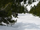
The start of the trail was mostly bare with thin snow starting soon after. It was 32 degrees and the snow was still very hard. There are several small logs down but none were a problem to get around. Footprints in the snow made it apparent that there was one person ahead of us this day. The snow remained thin until we began to climb above Stafford Creek. At about two miles I began to posthole and we stopped to put on snowshoes. I think we wore snowhoes more this day than on all other trips this winter combined. The person ahead also put on snowshoes at this point. We followed the main trail then began to traverse higher up the slope. This negated the switchbacks in the summer trail. The thin forest in this valley made it easy to avoid tree wells.
As we neared the creek we left the snowshoe tracks and headed more straight up the slope. We found the summer trail and followed it over to the creek. On previous snow scrambles I have either gone to Navaho Pass or turned uphill after the creek crossing. This time we headed straight up before the crossing. The route is very steep at the bottom. The snow was hard and we had good grip with the snowshoes. After about 200' the grade moderated. Half way up we ran into the snowshoe tracks we followed earlier. This person headed up earlier, crossed our route, dropped down and crossed the creek, then went straight up Navaho's face. His route looked steep with exposed rocks. I much preferred our way.
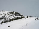
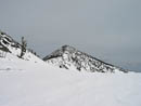
We now had a great view behind us of Earl Peak. The day started crystal clear but now high clouds began to move in. We reached the pass below Little Navaho at 12:15. We gained 1000' from the trail in 2/3 of a mile. The pass was a good spot for lunch. Earl Peak was to the west and Three Brothers was northeast. The recent snows has these 7000' peaks cloaked in winter white. From the pass it is 1250' of gain in one long mile to the summit.
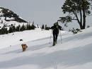
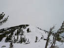
Just above the pass we took off our snowshoes. A short section was bare scree then we had to scramble through some rock. I was afraid Suzanne's dog Sadie would not be able to scramble up a short steep snow slope but she climbed right up it. Above that the grade moderated as we worked our way over to where the County Line Trail crosses the ridge. There were some sizable cornices to avoid in this stretch. From the County Line Trail it was an easy walk up the ridge. We soon reconnected with the lone snowshoer's track one more time. The summit rocks were snow covered. There was no way to find the register. Although the snow pack is thin, there was more snow on the 7223' summit than I have ever seen.
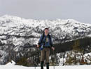
The clear skies of the morning were now gone as a high overcast set in. We could see a little of the base of Mt. Rainier. To the west the peaks of the Cascade crest stood out and of course Mt. Stuart and the Stuart Range dominated the view to the north. Best of all, there was very little wind on the summit. We discussed our return route and decided to head down the summer route rather than retracing our steps. We found snowshoe prints on the summer route. They headed way too far to the right but later they came back to the route.
There is a flat open ridge part way down where the County Line Trail heads across the face of Navaho and the scramble route heads up. At this point we left the route to Navaho Pass and headed straight down. The snow had been softening all morning and now was very soft. Two to three feet of soft snow has fallen on no base. The result is that in the warm afternoon I occasionally postholed all the way to my crotch even with snowshoes on. We made good time although pulling myself out of those holes took a lot of effort. After 1600' of descent on nice terrain the route steepened and became more forested. Soon we ran into the snowshoe tracks that had gone towards Navaho Pass then to the summit. We followed these tracks back to the creek.
The creek crossing can be difficult but there was only a few feet of snow there and we had no trouble getting across. We now picked up our own uphill tracks augmented by many others. It looked like half a dozen others had been up after us this day. The snow was so soft that I continued to posthole though much less than higher up. We left the snowshoes on much longer for the decent. Finally they came off and we continued back to the trailhead. The last mile was along the road again and we reached the car at 5:00. Just another 9:00 to 5:00 day in the mountains. This proved to be a nice alternative ascent route. Looping up one ridge and down another proved to be a lot of fun. For the day we covered 12 miles with about 4500' of gain.
Click on thumbnails to get larger pictures.
Photo Page 2
Trips - 2005
Home
The start of the trail was mostly bare with thin snow starting soon after. It was 32 degrees and the snow was still very hard. There are several small logs down but none were a problem to get around. Footprints in the snow made it apparent that there was one person ahead of us this day. The snow remained thin until we began to climb above Stafford Creek. At about two miles I began to posthole and we stopped to put on snowshoes. I think we wore snowhoes more this day than on all other trips this winter combined. The person ahead also put on snowshoes at this point. We followed the main trail then began to traverse higher up the slope. This negated the switchbacks in the summer trail. The thin forest in this valley made it easy to avoid tree wells.
As we neared the creek we left the snowshoe tracks and headed more straight up the slope. We found the summer trail and followed it over to the creek. On previous snow scrambles I have either gone to Navaho Pass or turned uphill after the creek crossing. This time we headed straight up before the crossing. The route is very steep at the bottom. The snow was hard and we had good grip with the snowshoes. After about 200' the grade moderated. Half way up we ran into the snowshoe tracks we followed earlier. This person headed up earlier, crossed our route, dropped down and crossed the creek, then went straight up Navaho's face. His route looked steep with exposed rocks. I much preferred our way.
We now had a great view behind us of Earl Peak. The day started crystal clear but now high clouds began to move in. We reached the pass below Little Navaho at 12:15. We gained 1000' from the trail in 2/3 of a mile. The pass was a good spot for lunch. Earl Peak was to the west and Three Brothers was northeast. The recent snows has these 7000' peaks cloaked in winter white. From the pass it is 1250' of gain in one long mile to the summit.
Just above the pass we took off our snowshoes. A short section was bare scree then we had to scramble through some rock. I was afraid Suzanne's dog Sadie would not be able to scramble up a short steep snow slope but she climbed right up it. Above that the grade moderated as we worked our way over to where the County Line Trail crosses the ridge. There were some sizable cornices to avoid in this stretch. From the County Line Trail it was an easy walk up the ridge. We soon reconnected with the lone snowshoer's track one more time. The summit rocks were snow covered. There was no way to find the register. Although the snow pack is thin, there was more snow on the 7223' summit than I have ever seen.
The clear skies of the morning were now gone as a high overcast set in. We could see a little of the base of Mt. Rainier. To the west the peaks of the Cascade crest stood out and of course Mt. Stuart and the Stuart Range dominated the view to the north. Best of all, there was very little wind on the summit. We discussed our return route and decided to head down the summer route rather than retracing our steps. We found snowshoe prints on the summer route. They headed way too far to the right but later they came back to the route.
There is a flat open ridge part way down where the County Line Trail heads across the face of Navaho and the scramble route heads up. At this point we left the route to Navaho Pass and headed straight down. The snow had been softening all morning and now was very soft. Two to three feet of soft snow has fallen on no base. The result is that in the warm afternoon I occasionally postholed all the way to my crotch even with snowshoes on. We made good time although pulling myself out of those holes took a lot of effort. After 1600' of descent on nice terrain the route steepened and became more forested. Soon we ran into the snowshoe tracks that had gone towards Navaho Pass then to the summit. We followed these tracks back to the creek.
The creek crossing can be difficult but there was only a few feet of snow there and we had no trouble getting across. We now picked up our own uphill tracks augmented by many others. It looked like half a dozen others had been up after us this day. The snow was so soft that I continued to posthole though much less than higher up. We left the snowshoes on much longer for the decent. Finally they came off and we continued back to the trailhead. The last mile was along the road again and we reached the car at 5:00. Just another 9:00 to 5:00 day in the mountains. This proved to be a nice alternative ascent route. Looping up one ridge and down another proved to be a lot of fun. For the day we covered 12 miles with about 4500' of gain.
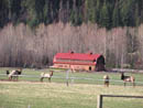
Elk Herd |
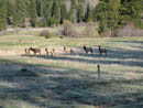
More Elk |
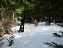
Snowshoes Time |
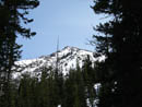
Little Navaho |
Climbing |
Suanne And Sadie |
Near The Pass |
Jim And Earl Peak |
Three Brothers |
Navaho Ridge |
Photo Page 2
Trips - 2005
Home