3-25-05
Good Friday is a holiday in my business and I
usually take advantage of it to find solitude on the trail. The
mountains looked to be wet and I wanted something other than Tiger
Mountain so I finally
headed to a place that I have meant to explore for years. Oyster Dome
sits
very near Puget Sound about a dozen miles south of Bellingham. The
trailhead
is only about 3 miles from exit 240, Alger, on Interstate 5. I filled
up
my gas tank at 145th and Greenwood in North Seattle and it was 70.5
miles
to the trailhead. I found a map on the
internet which showed a lower and higher trailhead. I figured I would
start at the lower one to maximize the distance. The lot is large
enough for a few dozen cars and a new looking bathroom is on the site.
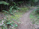
I was ready to go by 8:30. I looked for the trail near the big
Blanchard Hill Trail sign. A bermed old road started out. It soon ended
and a rough boot path headed on. After scrambling down a steep slope
and reaching a wide dry
stream bed I concluded this was not a trail. Back I went. I decided
since
there was no trail I would drive up to the upper trailhead.
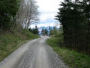
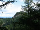
A short drive and I saw...the real trailhead. Back I went and I now walked the road to the trail. I should have looked closer at the map. A sign at the parking lot would have been useful. The real trail is quite nice. It is mostly on old roads narrowed to nice trail. After about a mile I reached the upper trailhead. There is a sign pointing the way I came but no signs pointing to where the trail continued. I again should have consulted the map. I didn't. I headed up the road to my right. I reached a gate in a short distance. It was locked. I continued on. Soon it was apparent that this was not the way to find the Lily Lake Trail. I knew the road would reach the Incline Trail so that was my new plan.
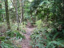
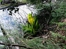
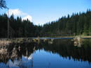
About a mile along the road I saw an obvious trail on the left. There was no sign visible from the road but a short way in there were signs. The Incline Trail went to the left and the Incline Alternate Trail went right. The Incline is straight up and the Alternate is more gently graded. I went right on the Alternate. There were a lot of signs of old logging on this trail. Wire cables were especially prevalent. After a steady climb the route moved onto an old railroad grade. The two trails came back together and soon reached the higher railroad grade. A sign pointed right 1/4 mile to Lizard Lake and left to Lily Lake. I turned right. Very quickly I reached Lizard Lake. It is not large but is a nice lake. I saw skunk cabbage along the shore. I would see much more of it this day.
The map showed a route from Lizard Lake to Lily Lake. I took a tiny boot path uphill and reached a flat area where the route disappeared. The distance to Lily Lake was short but I chose not to do a solo cross country bushwhack. I dropped back to Lizard Lake and was soon back at the top of the Incline Trail. This time I took the railroad grade on the route to Lily Lake. The next intersection had a trail going left and one right. The left was unsigned and the right said Lily Lake. The left turned out to be the Lily Lake Trail I had missed at the upper trailhead and would be my return route.
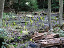
More nearly level travel and I reached a small lake on the right. Another trail turned left and it was signed "Max's Shortcut". Just beyond was another sign pointed right to Lily Lake. I scanned the map and pinpointed my position. I decided to continue straight ahead towards Oyster Dome. On my left was a wide muddy area with lots of skunk cabbage. As with the others, they had few leaves but there were many bright yellow spathes. At the next intersection the left route was signed for the Dome Trail. I dropped down and crossed a creek then began the climb to the top of Oyster Dome. At the viewpoint I saw one couple and heard another close by. I said "hi" and the couple did not even acknowledge my presence from 10 feet away. Oh well... I headed up to the highest point which had a view out to the north. I could see North Butte from there. It was 12:00 and time for lunch.
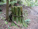
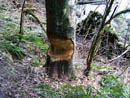
I then dropped back to the viewpoints and found a place out of sight of the others. The clouds hampered the view a little but it was still impressive. I will need to come back on a clear day. It was windy and cold at the viewpoint. After 20 minutes I had to get going. All to soon I caught up with the couple. I gave a cheerful salutation as I passed and again received no response. O for two... As I neared the Lily Lake turn off and the muddy stretch I saw why it was so muddy. A beaver dam had blocked the creek. With more water it would be a long skinny lake but now it was a long mud patch. Numerous trees were chewed through along here. At the intersection I turned left to Lily Lake. I immediately saw another bigger beaver dam. The beavers seem to be very busy around here.
Previous trip reports said Lily Lake was just a small mud hole. I found it to be a nice small lake full of water. I decided to head on and look for the route up North Butte. After following the lake shore the trail headed uphill. It was very muddy here but I managed to pick a dry route through lots of mud. The path was easy to follow and ended at a rocky spot. From the top of the rock I could see Oyster Dome and out to salt water. I climbed down and headed into the woods. A short distance led to an opening in the trees. I could see the bottom half of Mt. Baker. Without the clouds this would be a great close up view of the mountain. I then headed down and was back at the lake in no time. From the lake I passed Max's Shortcut which was another route that would have taken me back. Instead I backtracked to the Lily Lake Trail and took it down.
This is a very nice trail which drops in several long gentle switchbacks. From North Butte to the upper trailhead was about 4 miles. I passed several hikers coming up. When I reached the main road I turned uphill and in a short distance reached the upper parking lot. It was about 1 mile down to the lower trailhead and my car. This is a great area to hike. There are great views out to islands and salt water, several lakes, and great loop opportunities. It was really nice to go somewhere I have never hiked as well. The high point of my trip was about 2200' but with all the ups and downs I managed to get in 2700' of gain. Now I just need to come back on a sunny day.
Click on thumbnails to get larger pictures.
Photo Page 2
Trips - 2005
Home
A short drive and I saw...the real trailhead. Back I went and I now walked the road to the trail. I should have looked closer at the map. A sign at the parking lot would have been useful. The real trail is quite nice. It is mostly on old roads narrowed to nice trail. After about a mile I reached the upper trailhead. There is a sign pointing the way I came but no signs pointing to where the trail continued. I again should have consulted the map. I didn't. I headed up the road to my right. I reached a gate in a short distance. It was locked. I continued on. Soon it was apparent that this was not the way to find the Lily Lake Trail. I knew the road would reach the Incline Trail so that was my new plan.
About a mile along the road I saw an obvious trail on the left. There was no sign visible from the road but a short way in there were signs. The Incline Trail went to the left and the Incline Alternate Trail went right. The Incline is straight up and the Alternate is more gently graded. I went right on the Alternate. There were a lot of signs of old logging on this trail. Wire cables were especially prevalent. After a steady climb the route moved onto an old railroad grade. The two trails came back together and soon reached the higher railroad grade. A sign pointed right 1/4 mile to Lizard Lake and left to Lily Lake. I turned right. Very quickly I reached Lizard Lake. It is not large but is a nice lake. I saw skunk cabbage along the shore. I would see much more of it this day.
The map showed a route from Lizard Lake to Lily Lake. I took a tiny boot path uphill and reached a flat area where the route disappeared. The distance to Lily Lake was short but I chose not to do a solo cross country bushwhack. I dropped back to Lizard Lake and was soon back at the top of the Incline Trail. This time I took the railroad grade on the route to Lily Lake. The next intersection had a trail going left and one right. The left was unsigned and the right said Lily Lake. The left turned out to be the Lily Lake Trail I had missed at the upper trailhead and would be my return route.
More nearly level travel and I reached a small lake on the right. Another trail turned left and it was signed "Max's Shortcut". Just beyond was another sign pointed right to Lily Lake. I scanned the map and pinpointed my position. I decided to continue straight ahead towards Oyster Dome. On my left was a wide muddy area with lots of skunk cabbage. As with the others, they had few leaves but there were many bright yellow spathes. At the next intersection the left route was signed for the Dome Trail. I dropped down and crossed a creek then began the climb to the top of Oyster Dome. At the viewpoint I saw one couple and heard another close by. I said "hi" and the couple did not even acknowledge my presence from 10 feet away. Oh well... I headed up to the highest point which had a view out to the north. I could see North Butte from there. It was 12:00 and time for lunch.
I then dropped back to the viewpoints and found a place out of sight of the others. The clouds hampered the view a little but it was still impressive. I will need to come back on a clear day. It was windy and cold at the viewpoint. After 20 minutes I had to get going. All to soon I caught up with the couple. I gave a cheerful salutation as I passed and again received no response. O for two... As I neared the Lily Lake turn off and the muddy stretch I saw why it was so muddy. A beaver dam had blocked the creek. With more water it would be a long skinny lake but now it was a long mud patch. Numerous trees were chewed through along here. At the intersection I turned left to Lily Lake. I immediately saw another bigger beaver dam. The beavers seem to be very busy around here.
Previous trip reports said Lily Lake was just a small mud hole. I found it to be a nice small lake full of water. I decided to head on and look for the route up North Butte. After following the lake shore the trail headed uphill. It was very muddy here but I managed to pick a dry route through lots of mud. The path was easy to follow and ended at a rocky spot. From the top of the rock I could see Oyster Dome and out to salt water. I climbed down and headed into the woods. A short distance led to an opening in the trees. I could see the bottom half of Mt. Baker. Without the clouds this would be a great close up view of the mountain. I then headed down and was back at the lake in no time. From the lake I passed Max's Shortcut which was another route that would have taken me back. Instead I backtracked to the Lily Lake Trail and took it down.
This is a very nice trail which drops in several long gentle switchbacks. From North Butte to the upper trailhead was about 4 miles. I passed several hikers coming up. When I reached the main road I turned uphill and in a short distance reached the upper parking lot. It was about 1 mile down to the lower trailhead and my car. This is a great area to hike. There are great views out to islands and salt water, several lakes, and great loop opportunities. It was really nice to go somewhere I have never hiked as well. The high point of my trip was about 2200' but with all the ups and downs I managed to get in 2700' of gain. Now I just need to come back on a sunny day.
Violets |
Road Walk |
Above Incline |
Logging Relics |
Skunk Cabbage |
Lizard Lake |
Half Eaten |
More Skunk Cabbage |
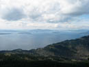
Oyster Dome View |
North Butte |
Photo Page 2
Trips - 2005
Home