5-29-05
I last did this loop in 1995. After 10 years it was
time for a return. The record hot weather ended with low clouds all the
way to the trailhead. We hoped it would burn off by the time we made it to
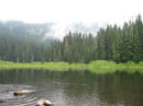
the summit. Suzanne joined me and we were at the 2960' Twin Lakes trailhead,
up the road from Hyak, at 9:00 AM. Although it was a holiday weekend there
were no other cars. The trail to Twin Lakes is an easy one mile gaining only
about 200'. At the lake we met two hikers going from Stampede Pass to Snoqualmie
Pass. The trailhead sign states it is one mile from Twin Lakes to the Pacific
Crest Trail. In reality it is at least 1 1/2 miles gaining 1400'. It was
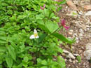
a little wet but in good shape over all. We saw many trillium. They were
about finished down low but in full bloom higher up. Violets, bunchberry,
and marsh marigolds were seen in profusion. The clouds made for a comfortably
cool ascent.
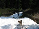
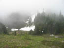
The Crest Trail was in very good shape. Many creeks were running strong but none were hard to get across. Most of the way was bare but there were several snow patches as well. The sky was still cloudy but it seemed to be getting thinner. The dogs, Sadie and Evie, enjoyed the cool weather and plentiful water. Sadie especially made a point of playing in all the snow patches. When we reached the tarn on the right side of the trail I knew we were close to the turn off for the abandoned trail up Silver Peak. The trail is easy to miss but there is now a large cairn which is hard to miss.
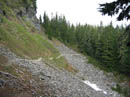
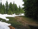
The old trail is in decent shape and easy to follow. The worst parts are the slick muddy section near the ridge top. We found the worst sections were buried under a thin snow cover. It made for much easier travel. The ridge top itself was snow free. In fact, there was little snow until the flat area at the base of the final climb up the south ridge of Silver. As we traversed along the sun finally broke through. We could now see the summit of Silver. The start of the final ridge was covered in glacier lilies. Along the way we saw short-stemmed Indian paintbrush. They only grew several inches tall. Phlox was also blooming along the rocky slope.
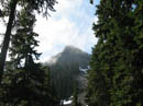
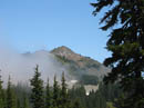
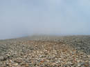
We traversed below the false summit and started up the final slope. Tinkham Peak was clear and we could now see Lost Lake as well as Lake Keechelus. Abiel Peak was partly in the clouds with the summit an island above the clouds. We reached the top at 11:55 after a leisurely 3 hour hike. Everything to the west was buried by the clouds. To the east most areas were bathed in sunshine. For the first time this year we were assaulted by mosquitos. I had to put on a coat to keep them at bay. A little wind would have helped but it was calm.
I remember a summit register from previous visits but there was none this day. The view from this summit is far better than it's elevation would suggest. I could pick out Rainier, Stuart, Hibox, Lemah, Alta, Thompson, Red, Snoqualmie, Chair, Kaleetan, and Granite. After lunch I headed a short way down the ridge to where Annette Lake would have been in view but with the thick clouds I could not see it. We quickly descended to the bottom of the ridge. As we began to traversed along the lower ridge we met several groups coming up. The drop back to the PCT went fast.
Back at the Crest Trail we turned left. The trail was in great condition. Much water crossed the route but little was on it. Flowers along here were better than I expected. Trillium was still seen in great numbers. One clump had more than a dozen blooms tightly packed together. As we neared Windy Pass we again entered the cloud zone. At the road we turned right and headed down about 1/4 mile to where the signed Mt. Catherine trail turned off to the right. This trail is steep at first before moderating. Most of it was in good shape with some water, mud, and rocks in places. As we headed east the clouds quickly gave way to sunny skies again.
The route flattens out as it drops to Twin Lakes. The dogs took advantage of the lake for a final swim. From the lake a short mile brought us back to the trailhead. The hike up Silver from Windy Pass is much shorter, with less elevation gain, and many more people. This loop is my preferred way to go. After several hot days the cooler weather was very nice. At the same time our route was much sunnier than any hike on the west side of the crest this day. It turned out to be a very nice day in the mountains.
Click on thumbnails to get larger pictures.
Photo Page 2
Trips - 2005
Home
The Crest Trail was in very good shape. Many creeks were running strong but none were hard to get across. Most of the way was bare but there were several snow patches as well. The sky was still cloudy but it seemed to be getting thinner. The dogs, Sadie and Evie, enjoyed the cool weather and plentiful water. Sadie especially made a point of playing in all the snow patches. When we reached the tarn on the right side of the trail I knew we were close to the turn off for the abandoned trail up Silver Peak. The trail is easy to miss but there is now a large cairn which is hard to miss.
The old trail is in decent shape and easy to follow. The worst parts are the slick muddy section near the ridge top. We found the worst sections were buried under a thin snow cover. It made for much easier travel. The ridge top itself was snow free. In fact, there was little snow until the flat area at the base of the final climb up the south ridge of Silver. As we traversed along the sun finally broke through. We could now see the summit of Silver. The start of the final ridge was covered in glacier lilies. Along the way we saw short-stemmed Indian paintbrush. They only grew several inches tall. Phlox was also blooming along the rocky slope.
We traversed below the false summit and started up the final slope. Tinkham Peak was clear and we could now see Lost Lake as well as Lake Keechelus. Abiel Peak was partly in the clouds with the summit an island above the clouds. We reached the top at 11:55 after a leisurely 3 hour hike. Everything to the west was buried by the clouds. To the east most areas were bathed in sunshine. For the first time this year we were assaulted by mosquitos. I had to put on a coat to keep them at bay. A little wind would have helped but it was calm.
I remember a summit register from previous visits but there was none this day. The view from this summit is far better than it's elevation would suggest. I could pick out Rainier, Stuart, Hibox, Lemah, Alta, Thompson, Red, Snoqualmie, Chair, Kaleetan, and Granite. After lunch I headed a short way down the ridge to where Annette Lake would have been in view but with the thick clouds I could not see it. We quickly descended to the bottom of the ridge. As we began to traversed along the lower ridge we met several groups coming up. The drop back to the PCT went fast.
Back at the Crest Trail we turned left. The trail was in great condition. Much water crossed the route but little was on it. Flowers along here were better than I expected. Trillium was still seen in great numbers. One clump had more than a dozen blooms tightly packed together. As we neared Windy Pass we again entered the cloud zone. At the road we turned right and headed down about 1/4 mile to where the signed Mt. Catherine trail turned off to the right. This trail is steep at first before moderating. Most of it was in good shape with some water, mud, and rocks in places. As we headed east the clouds quickly gave way to sunny skies again.
The route flattens out as it drops to Twin Lakes. The dogs took advantage of the lake for a final swim. From the lake a short mile brought us back to the trailhead. The hike up Silver from Windy Pass is much shorter, with less elevation gain, and many more people. This loop is my preferred way to go. After several hot days the cooler weather was very nice. At the same time our route was much sunnier than any hike on the west side of the crest this day. It turned out to be a very nice day in the mountains.
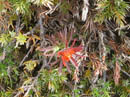
Trillium |
Twin Lake |
Pacific Crest Trail |
Tinkham Peak |
Evie On Snow |
Silver Peak |
Final Meadow |
Rocky Route |
Meadow Below |
Paintbrush? |
Photo Page 2
Trips - 2005
Home