7/09-10/05
This was a last minute planned overnight backpack
trip. The weather looked poor but Gary was free and we chose to head east
to avoid as much rain as possible. It turned out to be an excellent choice.
We drove up the North Fork Teanaway Road and Beverly Creek Road to the Beverly
trailhead at about 3650'. There were only 3 or 4 vehicles when we departed
at about 9:15 AM. Gary had lots of new lightweight gear so this was a good
opportunity to test it on a one night trip. We were both carrying just over
20 lbs. which is much less than just a few years ago. The crossing of Bean
Creek was a snap and soon we were out of the forest in the lower basin. The
flowers here were as good as I have seen for this valley. Lots of lupine,
gilia, and paintbrush. We set up camp just beyond the Fourth Creek trail
intersection at about 5250'. There was still plenty of water running in Beverly
Creek as well as a number of smaller creeks.
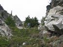
Once we had our campsite organized it was time to head out for a scramble of Bill Peak. The climb to Fourth Creek Pass was short and we left the trail there. Gary and I had separately scrambled Bill Peak years before via a scree traverse around the east side before heading up. Neither of us found that to be a particularly good route. This time we chose to head straight up the barren south side. This route is moderately steep but not difficult. Once on the ridge the going became easier. We managed to avoid both rock fields and forest as we wound our way higher. We soon found ourselves at the base of a grassy gully heading towards the summit. This route went very well. We topped out on the summit just in time for lunch.
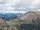
It was mostly cloudy in the morning but sunshine broke out on the summit. The tip of Mt. Stuart was in clouds but most other peaks, including the Cascade crest, were clear. This really is a nice vantage point with nearly all the Teanaway Peaks visible. To the left of Mt. Stuart was a clear view of Highchair and Bootjack Mountains . I scrambled those Icicle Creek peaks last month. Since we were camped just down in the valley, time was not a major concern. We spent at least an hour on top. We made a slight error on the descent, ending up at a big rock field. A rightward traverse brought us back on track. The final descent to Fourth Creek Pass was very easy as we plunge stepped and rock glissaded the scree.
Back at camp we pumped more water and immediately headed out for summit #2, Teanaway Peak. I have done Teanaway a number of times via the ridge from Beverly-Turnpike Pass. One time on a similar three peaks day we scrambled up from the Iron Peak Saddle. We stayed too far left and ended up with a very difficult rock climb. I was interested in finding the easier route I had read about. Gary had been down that ridge many years before but it was on snow. With all that in mind, we headed up to the Iron Peak Saddle directly below Teanaway Peak. On the last right hand switchback below the pass we headed off trail. A nice route went up then dropped down to the prominent gully. We couldn't be certain that the gully route worked but it was clear that a nice ramp to the right would go. This route was covered in wildflowers. Coralroot in bright red and yellow lit up the barren slope along with numerous other flowers. This proved to be a very nice bonus to the scramble.
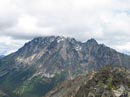
Once up the ramp it was an easy walk to the east ridge and from there to the 6779' summit. Stuart was now out of the clouds and the view of the whole Stuart Range was spectacular. Only a little snow below Ingalls Peak remained in the Teanaway area. It was sun then clouds with a cold breeze but we bundled up and enjoyed a nice long summit stay. The summit register is in a huge white PVC tube. It's so big Gary could see it with binoculars from Bill Peak. It was sealed tight. I hammered on the lip with a rock, working my way around. After a goodly amount of pounding the lid popped off. Inside was the mushy, soaked remains of the register notebook. The pages have congealed into a big white blob. If anyone is planning a visit bring along a new register.
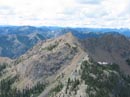
Just as we began to head down I saw a flower I have never seen before. It had a dozen or more tightly packed blooms in one mass. It has since been identified as the Olympic Onion. Thanks Marta. The flowers seemed even brighter on our descent. The descent back to the pass was a breeze. From there we had only about 400' to gain along the ridge to the summit of Iron Peak. We had seen people on the Iron Ridge from our Teanaway viewpoint. It looked like they had all departed by the time we were down to the ridge. We were surprised to see two people on the summit. They were only the second group we had seen all day. They left soon after and we had the mountain to ourselves. With camp being only 2 miles below we could enjoy a long summit stay. As the sun began to set we headed down, arriving back at camp at about 7:45 PM. By the time we finished dinner it was nearly dark. For the day we traveled about 9 miles, gaining 5300', and reaching three summits.
Day 2 depended on the weather. If it was raining we planned to head straight out. We awoke to a high overcast but no rain. Plan 2 was to head out over Bean Peak and down through Bean Creek Basin. This time we would be scrambling with our full overnight packs. With my old 40+ lb. load I never would have tried it. The hike from Fourth Creek Pass to Volcanic Neck was as nice as usual. Some flowers remain but most are past their peak. Once on the saddle next to Volcanic Neck I had a change of heart. I had tried to scramble it alone a dozen years earlier but turned back in the gully. Gary agreed to give it a try. We dropped down around the right side of the Neck and climbed back up to the north ridge.
The gully is full of loose dirt and scree as I remembered. We climbed higher and found an obvious ascending ramp to the right. The exposure is quite extreme as a slip would send you down hundreds of feet. The ramp entered a final short and narrow gully to the summit. I could easily have climbed the final 15' to the summit but was not so sure about descending it. The bottom line is that I chickened out. With no rope that was just a little more than I'm comfortable with. We managed to descend the gully without knocking any rocks down on on each other and hiked back around to the pass we started from. From there it's a nice easy scramble to the summit of Bean Peak. Once again we bundled up for a nice long summit stay. By the time we reached Iron Peak the day before much of the Cascade crest was in clouds. This day the crest was again clear though the top of Stuart was back in the clouds.
Two other scramblers joined us on their way to Volcanic Neck and Point 6660 farther north on the ridge. Rather than head down the ridge as many do we headed right down the south face of the peak. It was a little trickier with big overnight packs but not too bad. From there we headed right in the direction of Judy Peak. After dropping through boulders the terrain became largely sloping meadow. The creeks were still running and the flowers were terrific. We saw acres of paintbrush, lupine, monkshood, gilia, shooting starts, and more. All in all, the flowers on this trip were far superior to what we expected. The contrast between lush green meadows with many colors and barren slopes with many colors was neat.
Once down in the basin we had a few minutes of misty drizzle. That was all the precipitation we encountered the whole weekend. The basin still has some good color. It's a little past the peak but still very nice. From there the hike out was fast. By 2:45 we were done. This proved to be a great trip. He reached 4 summits, traveled 15 miles, gained 7000', and saw many more flowers than expected. Chock up one more nice weekend in the Teanaway.
Click on thumbnails to get larger pictures.
Photo Page 2
Trips - 2005
Home
Once we had our campsite organized it was time to head out for a scramble of Bill Peak. The climb to Fourth Creek Pass was short and we left the trail there. Gary and I had separately scrambled Bill Peak years before via a scree traverse around the east side before heading up. Neither of us found that to be a particularly good route. This time we chose to head straight up the barren south side. This route is moderately steep but not difficult. Once on the ridge the going became easier. We managed to avoid both rock fields and forest as we wound our way higher. We soon found ourselves at the base of a grassy gully heading towards the summit. This route went very well. We topped out on the summit just in time for lunch.
It was mostly cloudy in the morning but sunshine broke out on the summit. The tip of Mt. Stuart was in clouds but most other peaks, including the Cascade crest, were clear. This really is a nice vantage point with nearly all the Teanaway Peaks visible. To the left of Mt. Stuart was a clear view of Highchair and Bootjack Mountains . I scrambled those Icicle Creek peaks last month. Since we were camped just down in the valley, time was not a major concern. We spent at least an hour on top. We made a slight error on the descent, ending up at a big rock field. A rightward traverse brought us back on track. The final descent to Fourth Creek Pass was very easy as we plunge stepped and rock glissaded the scree.
Back at camp we pumped more water and immediately headed out for summit #2, Teanaway Peak. I have done Teanaway a number of times via the ridge from Beverly-Turnpike Pass. One time on a similar three peaks day we scrambled up from the Iron Peak Saddle. We stayed too far left and ended up with a very difficult rock climb. I was interested in finding the easier route I had read about. Gary had been down that ridge many years before but it was on snow. With all that in mind, we headed up to the Iron Peak Saddle directly below Teanaway Peak. On the last right hand switchback below the pass we headed off trail. A nice route went up then dropped down to the prominent gully. We couldn't be certain that the gully route worked but it was clear that a nice ramp to the right would go. This route was covered in wildflowers. Coralroot in bright red and yellow lit up the barren slope along with numerous other flowers. This proved to be a very nice bonus to the scramble.
Once up the ramp it was an easy walk to the east ridge and from there to the 6779' summit. Stuart was now out of the clouds and the view of the whole Stuart Range was spectacular. Only a little snow below Ingalls Peak remained in the Teanaway area. It was sun then clouds with a cold breeze but we bundled up and enjoyed a nice long summit stay. The summit register is in a huge white PVC tube. It's so big Gary could see it with binoculars from Bill Peak. It was sealed tight. I hammered on the lip with a rock, working my way around. After a goodly amount of pounding the lid popped off. Inside was the mushy, soaked remains of the register notebook. The pages have congealed into a big white blob. If anyone is planning a visit bring along a new register.
Just as we began to head down I saw a flower I have never seen before. It had a dozen or more tightly packed blooms in one mass. It has since been identified as the Olympic Onion. Thanks Marta. The flowers seemed even brighter on our descent. The descent back to the pass was a breeze. From there we had only about 400' to gain along the ridge to the summit of Iron Peak. We had seen people on the Iron Ridge from our Teanaway viewpoint. It looked like they had all departed by the time we were down to the ridge. We were surprised to see two people on the summit. They were only the second group we had seen all day. They left soon after and we had the mountain to ourselves. With camp being only 2 miles below we could enjoy a long summit stay. As the sun began to set we headed down, arriving back at camp at about 7:45 PM. By the time we finished dinner it was nearly dark. For the day we traveled about 9 miles, gaining 5300', and reaching three summits.
Day 2 depended on the weather. If it was raining we planned to head straight out. We awoke to a high overcast but no rain. Plan 2 was to head out over Bean Peak and down through Bean Creek Basin. This time we would be scrambling with our full overnight packs. With my old 40+ lb. load I never would have tried it. The hike from Fourth Creek Pass to Volcanic Neck was as nice as usual. Some flowers remain but most are past their peak. Once on the saddle next to Volcanic Neck I had a change of heart. I had tried to scramble it alone a dozen years earlier but turned back in the gully. Gary agreed to give it a try. We dropped down around the right side of the Neck and climbed back up to the north ridge.
The gully is full of loose dirt and scree as I remembered. We climbed higher and found an obvious ascending ramp to the right. The exposure is quite extreme as a slip would send you down hundreds of feet. The ramp entered a final short and narrow gully to the summit. I could easily have climbed the final 15' to the summit but was not so sure about descending it. The bottom line is that I chickened out. With no rope that was just a little more than I'm comfortable with. We managed to descend the gully without knocking any rocks down on on each other and hiked back around to the pass we started from. From there it's a nice easy scramble to the summit of Bean Peak. Once again we bundled up for a nice long summit stay. By the time we reached Iron Peak the day before much of the Cascade crest was in clouds. This day the crest was again clear though the top of Stuart was back in the clouds.
Two other scramblers joined us on their way to Volcanic Neck and Point 6660 farther north on the ridge. Rather than head down the ridge as many do we headed right down the south face of the peak. It was a little trickier with big overnight packs but not too bad. From there we headed right in the direction of Judy Peak. After dropping through boulders the terrain became largely sloping meadow. The creeks were still running and the flowers were terrific. We saw acres of paintbrush, lupine, monkshood, gilia, shooting starts, and more. All in all, the flowers on this trip were far superior to what we expected. The contrast between lush green meadows with many colors and barren slopes with many colors was neat.
Once down in the basin we had a few minutes of misty drizzle. That was all the precipitation we encountered the whole weekend. The basin still has some good color. It's a little past the peak but still very nice. From there the hike out was fast. By 2:45 we were done. This proved to be a great trip. He reached 4 summits, traveled 15 miles, gained 7000', and saw many more flowers than expected. Chock up one more nice weekend in the Teanaway.
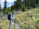
First Flowers |
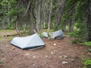
Camp Site |
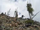
Scrambling Bill Peak |
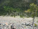
South Side Of Bill Pk |
Grassy Gully |
Fortune & Daniel |
Cloudy Mt. Stuart |
Teanaway Peak |
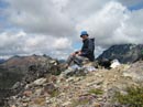
Gary On Bill Summit |
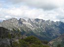
The Stuart Range |
Photo Page 2
Trips - 2005
Home