7-09-06
This one was a Mountaineer scramble. I always have
a good time on trips lead by Jay and Lindy. The name is unofficial. Apparently
it is also called Jupiter Peak. It is Point 7095 on the map, located just
north of Scatter Creek Pass above the Cle Elum River valley. We met at the
trailhead at 8:30 am. It's about 9 miles from the end of pavement. The trail
starts out level for a short distance then begins to climb. There are few
switchbacks but it is not overly steep either. Just a nice steady climb.
There were a few clouds moving in which kept the temperature comfortable at
first.
Bugs are appearing now. They were not horrible anywhere but present most everywhere. I have a few dozen mosquito bites to show for the day. The lower trail is in pretty good shape. It does not appear to get a great deal of maintenance. We climbed over 5 or six logs. One downed tree obscures the route but it is not hard to pick up again. At about 2 miles the trail splits. There is a yellow paper temporary trail marker on a tree. The County Line trail goes off right. The Scatter Creek trail heads left.
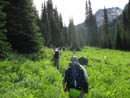
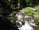
In a short distance the trail drops a little to a crossing of Scatter Creek. This was the hardest of many creek crossings on the day. I went from log to rock to several steps in the creek where it was widest and least deep. The rocks were very slick. Some made it across dry and several dunked there boots in deeper water. Getting across is not hard. Getting across with dry feet is. Once on the left side of the creek the terrain changed. Instead of continuous forest we were now in mostly meadows with some forest in between.
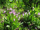
The meadows are bright green with high grass and with many flowers in bloom. Flowers began early on the trail and never let up. Trillium gave way to columbine and in the meadows we saw lupine, shooting star, elephant head, paintbrush, valerian, columbine, and many more. Nearer the summit phlox carpeted the ground. There were red tape markers entering and exiting the forest and some cairns on boulders in the meadows. Tread varied from minimal to almost none. The route is much more obvious since our 10 pairs of boots went up and down the meadows. The meadows were mostly dry but there are some short muddy sections.
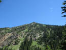
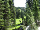
The next half a dozen creek crossings were manageable with dry feet. From the higher meadows we could see Fish Eagle Peak several thousand feet directly above us. The valley narrowed as we moved towards the head. It also steepened. The trail is never particularly steep. Some snow patches were in the upper valley but we only crossed a few and they were short. The south and west faces of Fish Eagle were snow free to the top.
One final creek crossing to the left side on a log brought us into a higher meadow. The trail continues up to Scatter Creek Pass. Turning left from the trail pointed to an open hillside all the way up to the ridge top. This was our off trail route. Much of the hillside is forested but this open gap provided an easy route up. The grade steepens considerably but the footing is good and there is no difficulty walking right up it. This is where lupine, and phlox provide a carpet through the grass. I saw some yellow paintbrush here as well.
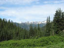
By now it was getting very warm. With no shade it was a slow slog up to the ridge top. From the ridge the views really improved. Over the ridge I could see Cashmere Mountain as well as Big Jim across the valley of Icicle Creek. Mt. Stuart loomed very close by. Much of the Cascade crest from Snoqualmie Pass to Mt. Daniel was in view. The route to the summit is on or just below the ridge the last 600'. Two of our group went ahead and I took off next. The only difficulty was finding out which bump was the actual summit.
I popped but up to the ridge very near the top and was soon on top. From 7095' the view was really outstanding. Rainier and Adams were southwest. The whole Cascade crest was in view. Sloan Peak peeked out the left side of a nearer peak and Mt. Baker was partly visible to the right. Glacier Peak was very clear. Mt. Stuart was much closer than I expected. Ingalls Peaks were just over Scatter Creek Pass. The basin of Lake Ann was easily seen. Right across from us was Harding Mountain. The Cradle was also close. On previous trips up Bootjack and Highchair Mountains I had great views of Harding and Fish Eagle. Now I had the reverse view of those peaks.
I spent a full hour on the summit. It was hot enough I felt less than great. Food and water helped but heading down helped the most. We dropped a little farther below the ridge on the descent. One could do a descending traverse back to the meadow but would have some trees to work through. We returned to the ridge top and descended straight back down to the meadow.
The hike out was just a long slog on a hot day. Some breeze and a few clouds made it more manageable. The many flowers also helped keep it interesting. In the last mile I saw a big black bear running through the trees. It was not that close and gone well before I could get my camera out. My water was gone and I was quite glad to reach the cars.
For the day we traveled about 12 miles with 3800' gained. It took about 3 1/2 hours up and a little less coming down. The maps are not generally accurate regarding this trail. I have TOPO software and it shows the County Line Trail but not the Scatter Creek Trail. It was taken from USGS maps I believe so that is also a problem. It also has the trailhead in the wrong place and shows non existent switchbacks. The most recent Green Trails does seem to be the most correct. This was a fun hike and my third new summit in an eight day period. I'm sure I'll be back some day.
Click on thumbnails to get larger pictures.
Photo Page 2
Trips - 2006
Home
Bugs are appearing now. They were not horrible anywhere but present most everywhere. I have a few dozen mosquito bites to show for the day. The lower trail is in pretty good shape. It does not appear to get a great deal of maintenance. We climbed over 5 or six logs. One downed tree obscures the route but it is not hard to pick up again. At about 2 miles the trail splits. There is a yellow paper temporary trail marker on a tree. The County Line trail goes off right. The Scatter Creek trail heads left.
In a short distance the trail drops a little to a crossing of Scatter Creek. This was the hardest of many creek crossings on the day. I went from log to rock to several steps in the creek where it was widest and least deep. The rocks were very slick. Some made it across dry and several dunked there boots in deeper water. Getting across is not hard. Getting across with dry feet is. Once on the left side of the creek the terrain changed. Instead of continuous forest we were now in mostly meadows with some forest in between.
The meadows are bright green with high grass and with many flowers in bloom. Flowers began early on the trail and never let up. Trillium gave way to columbine and in the meadows we saw lupine, shooting star, elephant head, paintbrush, valerian, columbine, and many more. Nearer the summit phlox carpeted the ground. There were red tape markers entering and exiting the forest and some cairns on boulders in the meadows. Tread varied from minimal to almost none. The route is much more obvious since our 10 pairs of boots went up and down the meadows. The meadows were mostly dry but there are some short muddy sections.
The next half a dozen creek crossings were manageable with dry feet. From the higher meadows we could see Fish Eagle Peak several thousand feet directly above us. The valley narrowed as we moved towards the head. It also steepened. The trail is never particularly steep. Some snow patches were in the upper valley but we only crossed a few and they were short. The south and west faces of Fish Eagle were snow free to the top.
One final creek crossing to the left side on a log brought us into a higher meadow. The trail continues up to Scatter Creek Pass. Turning left from the trail pointed to an open hillside all the way up to the ridge top. This was our off trail route. Much of the hillside is forested but this open gap provided an easy route up. The grade steepens considerably but the footing is good and there is no difficulty walking right up it. This is where lupine, and phlox provide a carpet through the grass. I saw some yellow paintbrush here as well.
By now it was getting very warm. With no shade it was a slow slog up to the ridge top. From the ridge the views really improved. Over the ridge I could see Cashmere Mountain as well as Big Jim across the valley of Icicle Creek. Mt. Stuart loomed very close by. Much of the Cascade crest from Snoqualmie Pass to Mt. Daniel was in view. The route to the summit is on or just below the ridge the last 600'. Two of our group went ahead and I took off next. The only difficulty was finding out which bump was the actual summit.
I popped but up to the ridge very near the top and was soon on top. From 7095' the view was really outstanding. Rainier and Adams were southwest. The whole Cascade crest was in view. Sloan Peak peeked out the left side of a nearer peak and Mt. Baker was partly visible to the right. Glacier Peak was very clear. Mt. Stuart was much closer than I expected. Ingalls Peaks were just over Scatter Creek Pass. The basin of Lake Ann was easily seen. Right across from us was Harding Mountain. The Cradle was also close. On previous trips up Bootjack and Highchair Mountains I had great views of Harding and Fish Eagle. Now I had the reverse view of those peaks.
I spent a full hour on the summit. It was hot enough I felt less than great. Food and water helped but heading down helped the most. We dropped a little farther below the ridge on the descent. One could do a descending traverse back to the meadow but would have some trees to work through. We returned to the ridge top and descended straight back down to the meadow.
The hike out was just a long slog on a hot day. Some breeze and a few clouds made it more manageable. The many flowers also helped keep it interesting. In the last mile I saw a big black bear running through the trees. It was not that close and gone well before I could get my camera out. My water was gone and I was quite glad to reach the cars.
For the day we traveled about 12 miles with 3800' gained. It took about 3 1/2 hours up and a little less coming down. The maps are not generally accurate regarding this trail. I have TOPO software and it shows the County Line Trail but not the Scatter Creek Trail. It was taken from USGS maps I believe so that is also a problem. It also has the trailhead in the wrong place and shows non existent switchbacks. The most recent Green Trails does seem to be the most correct. This was a fun hike and my third new summit in an eight day period. I'm sure I'll be back some day.
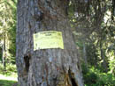
Trail Sign |
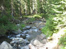
Scatter Ck Crossing |
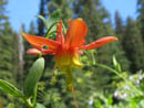
Columbine |
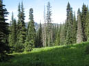
Lower Meadow |
Crossing Meadow |
Crest Peaks |
Another Crossing |
Fish Eagle Peak |
Shooting Stars |
Upper Meadow |
Photo Page 2
Trips - 2006
Home