5-06-06
Yet another warm sunny week followed by a dark and
wet weekend. We chose a close in snow scramble of Mt. Defiance. Suzanne,
Sadie, Trail Pair, and Bernadette joined me. Bernadette has been out of
the country and has not been able to get in any elevation gain. What better
way to ease back in than 11 miles mostly on snow with 3800' of gain. We met
at the Mason Lake trailhead at about 8:30 AM. The road is really potholed.
Drive slow. There were several other groups getting ready to go as well.
It rained off and on during the drive but it was not raining as we got started.
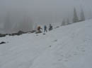
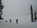
There was lots of water in the waterfall at Mason Creek. We debated whether to take the old trail of the new one. The old trail is still visible if you look for it. Not knowing the amount of snow cover at the big rock field we chose to take the new trail. No snow where the trail left the old road. A little patch was all we saw before the first switchback. On the open upper slopes the snow began. At the switchback before the rightward traverse to the Bandera summit trail we headed straight up the snow.
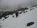
The snow became very thin as we neared a long talus field on the left. I headed up onto the rocks for easier travel. Not much farther up we came to bare trail right at the high point where the trail drops down to Mason Lake. Only this point was bare the trail heading back to the Bandera summit spur was completely under snow. The new Ira Spring trail is a civilized way to Mason Lake, unlike the old trail. It does however switchback down a very steep slope to the lake. Early in the year it may tempt people to try a dangerous descent. The slope gets virtually zero sun and can be very hard.
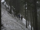
We discussed trying to descend and I volunteered to give it a try. The snow level was forecast to be 6000' this day but it was cold at this lower elevation. Previous footsteps were frozen solid. I found that I could kick steps to the side of the existing ones. An ice axe was necessary. I dropped about 20' then kicked steps on a level traverse along the slope. Again, the old steps were too hard to use. A slip would send you flying into the trees below. Until it melts out this descent is not one to make without an axe and knowledge how to use it. It seems two hikers reached the drop while we were descending, took one look and changed their destination.
The rest of the gang followed me down. Even Sadie the golden retriever bounded down the slope. The traverse brought us to moderate terrain where we could easily drop on down. We headed towards the lake reaching the shore at the southeast corner. The trail does not go this way and I had not been there before. The clouds were at ground level and we could not see far out onto the lake. We followed the shore around to the outlet and across. A small area at the outlet is open but the rest of the lake is still snow covered.
Since dropping down from above the lake the snow was at least several feet deep. We headed along the lake and in the general direction of the Defiance Trail. It was easy to find the ridge. Some old footsteps were visible along the ridge. The summer trail follows the ridge above Lake Kulla Kulla, traverses below the ridge then switchbacks up to the ridge again. With all the snow it is much easier to just stay on the ridge top all the way to the summit.
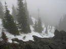
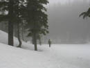
We put on snowshoes as much for traction as flotation. At about 4400' it began to snow. We were far below the forecast snow level but happy to get snowed on rather than rained on. The ridge has a few steep sections but over all the grade is moderate. We were in the clouds most of the day. On the negative side there was no visibility. On the positive side this ridge seemed isolated and alpine although it is right above a major interstate highway. The clouds also muffled all the noise.
We reached a flat spot about 400' from the summit. There was a short steep slope here and the snow was getting harder. We dumped the poles and snowshoes and switched to crampons and ice axes. That made a big difference as we cramponed up the steep spot and worked our way higher. There was one more tough spot where the snow was too thin. We chose to step off the snow and work over some rock and scrub trees to get back on the snow. From there it was an easy walk to the top.
Visibility was about 50'. It had been calm on the way up but a cold wind was blowing on the summit. Our stay was short. We quickly dropped back to our snowshoes to have lunch. We kept the crampons on for the descent. Not really necessary but the route went from soft to rock hard ice in a few feet and the crampons made it easy to keep from slipping.
Back at the lake we found no new footprints. It seems we were the only people to visit the lake this day. As is usually the case climbing back up the steep section was much easier than the descent. We slogged down the snow being careful as we postholed down to the talus below on numerous occasions. The last section we glissaded. This took us back onto the trail. Within 10 minutes we were off the snow for good. On the way down I noticed three trillium we missed on the way up. Suzanne spotted some bleeding hearts as well. The rest of the way was just the old road walk.
All in all it was a great day. We were snowed on a little but had no rain. We saw nobody after dropping down towards Mason Lake. The snow conditions were good. The ridge scramble is fun but not death defying. In a month or so it will be a nice summer trail walk with lots of wildflowers. For now it still feels like winter.
Click on thumbnails to get larger pictures.
Photo Page 2
Trips - 2006
Home
There was lots of water in the waterfall at Mason Creek. We debated whether to take the old trail of the new one. The old trail is still visible if you look for it. Not knowing the amount of snow cover at the big rock field we chose to take the new trail. No snow where the trail left the old road. A little patch was all we saw before the first switchback. On the open upper slopes the snow began. At the switchback before the rightward traverse to the Bandera summit trail we headed straight up the snow.
The snow became very thin as we neared a long talus field on the left. I headed up onto the rocks for easier travel. Not much farther up we came to bare trail right at the high point where the trail drops down to Mason Lake. Only this point was bare the trail heading back to the Bandera summit spur was completely under snow. The new Ira Spring trail is a civilized way to Mason Lake, unlike the old trail. It does however switchback down a very steep slope to the lake. Early in the year it may tempt people to try a dangerous descent. The slope gets virtually zero sun and can be very hard.
We discussed trying to descend and I volunteered to give it a try. The snow level was forecast to be 6000' this day but it was cold at this lower elevation. Previous footsteps were frozen solid. I found that I could kick steps to the side of the existing ones. An ice axe was necessary. I dropped about 20' then kicked steps on a level traverse along the slope. Again, the old steps were too hard to use. A slip would send you flying into the trees below. Until it melts out this descent is not one to make without an axe and knowledge how to use it. It seems two hikers reached the drop while we were descending, took one look and changed their destination.
The rest of the gang followed me down. Even Sadie the golden retriever bounded down the slope. The traverse brought us to moderate terrain where we could easily drop on down. We headed towards the lake reaching the shore at the southeast corner. The trail does not go this way and I had not been there before. The clouds were at ground level and we could not see far out onto the lake. We followed the shore around to the outlet and across. A small area at the outlet is open but the rest of the lake is still snow covered.
Since dropping down from above the lake the snow was at least several feet deep. We headed along the lake and in the general direction of the Defiance Trail. It was easy to find the ridge. Some old footsteps were visible along the ridge. The summer trail follows the ridge above Lake Kulla Kulla, traverses below the ridge then switchbacks up to the ridge again. With all the snow it is much easier to just stay on the ridge top all the way to the summit.
We put on snowshoes as much for traction as flotation. At about 4400' it began to snow. We were far below the forecast snow level but happy to get snowed on rather than rained on. The ridge has a few steep sections but over all the grade is moderate. We were in the clouds most of the day. On the negative side there was no visibility. On the positive side this ridge seemed isolated and alpine although it is right above a major interstate highway. The clouds also muffled all the noise.
We reached a flat spot about 400' from the summit. There was a short steep slope here and the snow was getting harder. We dumped the poles and snowshoes and switched to crampons and ice axes. That made a big difference as we cramponed up the steep spot and worked our way higher. There was one more tough spot where the snow was too thin. We chose to step off the snow and work over some rock and scrub trees to get back on the snow. From there it was an easy walk to the top.
Visibility was about 50'. It had been calm on the way up but a cold wind was blowing on the summit. Our stay was short. We quickly dropped back to our snowshoes to have lunch. We kept the crampons on for the descent. Not really necessary but the route went from soft to rock hard ice in a few feet and the crampons made it easy to keep from slipping.
Back at the lake we found no new footprints. It seems we were the only people to visit the lake this day. As is usually the case climbing back up the steep section was much easier than the descent. We slogged down the snow being careful as we postholed down to the talus below on numerous occasions. The last section we glissaded. This took us back onto the trail. Within 10 minutes we were off the snow for good. On the way down I noticed three trillium we missed on the way up. Suzanne spotted some bleeding hearts as well. The rest of the way was just the old road walk.
All in all it was a great day. We were snowed on a little but had no rain. We saw nobody after dropping down towards Mason Lake. The snow conditions were good. The ridge scramble is fun but not death defying. In a month or so it will be a nice summer trail walk with lots of wildflowers. For now it still feels like winter.
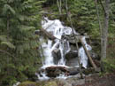
Waterfall |
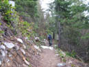
Bare Trail |
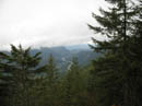
Cloud Level |
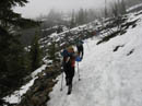
Snow Begins |
Another Group |
Heading Up Slope |
High Point |
Traverse |
Mason Lake? |
Lake Shore |
Photo Page 2
Trips - 2006
Home