2-26-06
There just aren't many good snowshoe or cross country
ski trails near Seattle which have little avalanche danger. There
is one little known jewel that provides moderately gentle terrain, deep
forest, lakes, and a pass on the crest of the Cascade Mountains. My friend
Gary had a hand in building this trail. It has been around for more than
15 years and I never tried it until this weekend. Gary had a work party
scheduled to replace blue diamond markers all along the route. We had a busy
day filling in gaps where diamonds are missing or covered by tree growth.
I made it much of the way up and Gary and others made it all the way up
to Nordic and down to Windy Pass. I will describe the section I snowshoed
and leave the latter part to Gary.
First a little history is in order. Not all that many years ago much of the area around Hyak (Summit East) was open for backcountry skiing. The earlier ski area concentrated on downhill and skinny skiers had forest and roads to explore. Now there is a large groomed cross country area and crossover trails between the ski areas. Gary and friends convinced the Forest Service that backcountry skiers still should be able to use the area south of Snoqualmie Pass. Thus the Nordic Pass Trail was conceived and built to serve backcountry skiers.
Today there are numerous groomed cross country areas along I-90 but not much undeveloped forest. Especially not much with little avalanche danger. The Nordic Pass Trail is ideal for skiers who would like to venture off groomed roads and try untracked skiing. It's also great for those with the skill to ski rapidly down through the trees. That would not be me. Today there are many snowshoers and it is a great trail for all levels of skill and fitness. There are blue diamonds from the start all the way to Nordic Pass and down to Windy Pass. If you can't see one ahead stop and scout around. It is possible to make it all the way up just following the diamonds. When the trees are snow plastered some diamonds are hidden by white but keep looking and you can find your way.
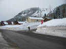
The trail begins off a street of cabins just above Hyak. Take Exit 54 (Hyak) off I-90 and turn left. Parking is at the Gold Creek Sno-Park. Permits are required. Walk under the highway and into the Summit East (Hyak) lot. A short way in is a stop sign. Turn to the right here and walk up the road. Quickly the road splits. Take another right. A little farther the main road heads uphill to the left. Go left. The road then makes a sharp turn to the left. The trail begins at this switchback.
This weekend the snow was 8 feet high and we had to dig a break in the wall to climb up. It only took a few minutes. The property owner at the top of the switchback does not want people on his property so climb up in the middle of the road corner. Once on top of the wall we quickly reached the creek. With all the snow this year it required dropping about 6 feet to a snow covered logjam then climbing back up. On the other side is a big tree with a "Nordic Pass Trail" sign.
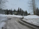
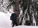
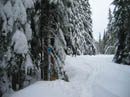
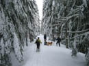
You should not have to go far to see the next diamond. The trail heads away from the road gaining elevation very gently. The sharpest turns have large blue diamonds with a turn arrow. Two horizontal diamonds also represent a turn. The route heads northwest and intersects the old cross pass railroad grade. Look for a diamond on the left which shows where to exit the grade. The route switches back and forth rather than going straight up the fall line. Very easy on snowshoes and sometimes requiring climbing skins for skiers.
The route generally follows close by Hyak Creek. A number times it almost reaches the creek and switchbacks away one again. There are several groomed cross country road/trails to cross. In each case you come out of the forest and head right back into it again. Look carefully to find a diamond on the other side. They are not always directly across but in no case do you proceed up or down the groomed roads any distance. The most difficult crossing is at the biggest crossover trail linking Summit Central and Summit East. There are wooden power poles along this trail which looks like a road. The route crosses and angles off to the right before entering the forest again. Be sure to look well off to the right uphill to see the next diamond.
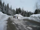
Once across this trail near 3400' more switchbacks lead up to a meadow. Continue to your right along the meadow and soon reach Hyak Lake. The trail leaves the initial road switchback at about 2760' and the lake is at 3525'. I was surprised to see a group of snowshoers on the other side of the snow covered lake. The terrain now becomes very gentle. We soon intersected the upper groomed cross country ski area. The trail crosses the groomed route with diamonds visible on both sides.
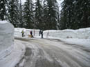
About the trickiest section to follow is near the metal-tower power line corridor. You can't miss the lines or likely miss the buzzing. In this corridor all the trees were cut down. Smaller trees have grown up but they are thick with downward sloping branches. There is no place to place diamonds on the trunks. Through here we hung diamonds from branches with wire. Keep an eye out for them. It was clear enough here to see Mt. Catherine with Nordic Pass on its lower northwest ridge and Silver Peak behind the pass. After a long morning and early afternoon of work Suzanne and I had to head back at this point. Now I'll let Gary describe the route from here.
After crossing underneath the power lines the trail crosses a groomed trail and heads back for a short distance through smaller trees until it reaches a fork in the groomed trail network. It was at this point that Jim and Suzanne headed back. It was 1:15 pm and I badly wanted to reach Windy Pass to put up the last Nordic Pass Trail sign. So at this point Ron, Andrejs and I stopped replacing diamonds and took off for the pass.
Two of the groomed forks head down. Go down along the right fork and look for diamonds on the trees to the left. Make a left turn towards the diamonds and continue past a large tree with a diamond. Shortly after this tree the trail turns right and switchbacks up the hill. The trail gets close to a groomed trail and then turns left where you will see a tree with a Nordic Pass Trail sign. At this tree turn right and follow the trail through a blowdown area. Past the blowdown area the trail heads west along a steep hillside. Outside of one notable dip, the trail generally heads up and climbing skins are helpful here. At about 3700 ft the trail heads south and the grade decreases.
Shortly before a pleasant meadow area with widely spaced trees we lost the diamonds. Either a few diamonds were missing or they were covered with snow. The trail heads through the middle of this area and crosses Dick’s Creek on a snow bridge. We picked up the diamonds at Dick’s Creek and had a short snack break. From Dick’s Creek we followed the trail south until we were just short of the slopes of Mt. Catherine and reached 3900 ft elevation. At this point the trail turned west and reached Nordic Pass at just over 4000 ft elevation. The Nordic Pass sign is on a small tree to the north of the low point of the pass.
At this point I should explain that there are three passes with small bumps in-between. The Nordic Pass Trail goes through the southern-most pass. This pass has pleasant slopes to the west with widely spaced trees and plenty of sun on sunny days. There are views through the trees towards Silver and Tinkham. The middle pass is the lowest pass and thus the real pass. It is cold and dark with no views. An old abandoned ski trail heads from this pass down towards Olallie Meadow.
At Nordic Pass, Ron who had skied the day before decided to take a much deserved break while Andrejs and I headed to Windy Pass to put up the Nordic Pass Trail sign. From Nordic Pass the trail dropped down to the snow gauge and then headed up a short slope before the steep descent to Windy Pass. The blue diamonds head straight down the slope. It is up to the skier to pick out his own switchbacks. Under icy conditions typically half or more of a skiing party will remove their skis and walk. But today we had nice soft snow so we skied down the hill.
Andrejs expertly descended the slope staying close to the fall line. I had left my skins on since we were about to turn around and head back up to Nordic Pass. I still managed to fall a couple times as I descended the hill. Near Windy Pass the trail enters an old clearcut. On the last big tree before the clearcut I put up the Nordic Pass Trail sign. This tree is visible from the Windy Pass area and you should be able to see the sign if you look for it.
After installing the sign we returned to Nordic Pass where Ron was patiently waiting and freezing. It was 3:15 and time to head out. We had a fun and quick run down the gentler grades of the upper half of the trail. On the lower half we got in several telemark turns and in my case telemark falls. By the time we walked back to the Gold Creek Sno-Park lot it was almost 5:30.
A couple final warnings: The blue diamond trail markers can be totally hidden by snow plastered on the trees. As the trees grow larger the diamonds eventually pop off and a few of the trees with diamonds have fallen over. So if you totally lose the trail and cannot find any more blue diamonds it is probably best to turn around.
Although in my non-expert opinion there is no avalanche danger along the Nordic Pass Trail, if you wander off the trail towards Mt. Catherine or Nordic Knob (aka Radio Mt.) you can find avalanche slopes.
For more information on the Nordic Pass Trail, to get a topo map with GPS waypoints (about 1 MB) or to volunteer for future work parties send an email to: Contact Gary .
Click on thumbnails to get larger pictures.
Photo Page 2
Trips - 2006
Home
First a little history is in order. Not all that many years ago much of the area around Hyak (Summit East) was open for backcountry skiing. The earlier ski area concentrated on downhill and skinny skiers had forest and roads to explore. Now there is a large groomed cross country area and crossover trails between the ski areas. Gary and friends convinced the Forest Service that backcountry skiers still should be able to use the area south of Snoqualmie Pass. Thus the Nordic Pass Trail was conceived and built to serve backcountry skiers.
Today there are numerous groomed cross country areas along I-90 but not much undeveloped forest. Especially not much with little avalanche danger. The Nordic Pass Trail is ideal for skiers who would like to venture off groomed roads and try untracked skiing. It's also great for those with the skill to ski rapidly down through the trees. That would not be me. Today there are many snowshoers and it is a great trail for all levels of skill and fitness. There are blue diamonds from the start all the way to Nordic Pass and down to Windy Pass. If you can't see one ahead stop and scout around. It is possible to make it all the way up just following the diamonds. When the trees are snow plastered some diamonds are hidden by white but keep looking and you can find your way.
The trail begins off a street of cabins just above Hyak. Take Exit 54 (Hyak) off I-90 and turn left. Parking is at the Gold Creek Sno-Park. Permits are required. Walk under the highway and into the Summit East (Hyak) lot. A short way in is a stop sign. Turn to the right here and walk up the road. Quickly the road splits. Take another right. A little farther the main road heads uphill to the left. Go left. The road then makes a sharp turn to the left. The trail begins at this switchback.
This weekend the snow was 8 feet high and we had to dig a break in the wall to climb up. It only took a few minutes. The property owner at the top of the switchback does not want people on his property so climb up in the middle of the road corner. Once on top of the wall we quickly reached the creek. With all the snow this year it required dropping about 6 feet to a snow covered logjam then climbing back up. On the other side is a big tree with a "Nordic Pass Trail" sign.
You should not have to go far to see the next diamond. The trail heads away from the road gaining elevation very gently. The sharpest turns have large blue diamonds with a turn arrow. Two horizontal diamonds also represent a turn. The route heads northwest and intersects the old cross pass railroad grade. Look for a diamond on the left which shows where to exit the grade. The route switches back and forth rather than going straight up the fall line. Very easy on snowshoes and sometimes requiring climbing skins for skiers.
The route generally follows close by Hyak Creek. A number times it almost reaches the creek and switchbacks away one again. There are several groomed cross country road/trails to cross. In each case you come out of the forest and head right back into it again. Look carefully to find a diamond on the other side. They are not always directly across but in no case do you proceed up or down the groomed roads any distance. The most difficult crossing is at the biggest crossover trail linking Summit Central and Summit East. There are wooden power poles along this trail which looks like a road. The route crosses and angles off to the right before entering the forest again. Be sure to look well off to the right uphill to see the next diamond.
Once across this trail near 3400' more switchbacks lead up to a meadow. Continue to your right along the meadow and soon reach Hyak Lake. The trail leaves the initial road switchback at about 2760' and the lake is at 3525'. I was surprised to see a group of snowshoers on the other side of the snow covered lake. The terrain now becomes very gentle. We soon intersected the upper groomed cross country ski area. The trail crosses the groomed route with diamonds visible on both sides.
About the trickiest section to follow is near the metal-tower power line corridor. You can't miss the lines or likely miss the buzzing. In this corridor all the trees were cut down. Smaller trees have grown up but they are thick with downward sloping branches. There is no place to place diamonds on the trunks. Through here we hung diamonds from branches with wire. Keep an eye out for them. It was clear enough here to see Mt. Catherine with Nordic Pass on its lower northwest ridge and Silver Peak behind the pass. After a long morning and early afternoon of work Suzanne and I had to head back at this point. Now I'll let Gary describe the route from here.
After crossing underneath the power lines the trail crosses a groomed trail and heads back for a short distance through smaller trees until it reaches a fork in the groomed trail network. It was at this point that Jim and Suzanne headed back. It was 1:15 pm and I badly wanted to reach Windy Pass to put up the last Nordic Pass Trail sign. So at this point Ron, Andrejs and I stopped replacing diamonds and took off for the pass.
Two of the groomed forks head down. Go down along the right fork and look for diamonds on the trees to the left. Make a left turn towards the diamonds and continue past a large tree with a diamond. Shortly after this tree the trail turns right and switchbacks up the hill. The trail gets close to a groomed trail and then turns left where you will see a tree with a Nordic Pass Trail sign. At this tree turn right and follow the trail through a blowdown area. Past the blowdown area the trail heads west along a steep hillside. Outside of one notable dip, the trail generally heads up and climbing skins are helpful here. At about 3700 ft the trail heads south and the grade decreases.
Shortly before a pleasant meadow area with widely spaced trees we lost the diamonds. Either a few diamonds were missing or they were covered with snow. The trail heads through the middle of this area and crosses Dick’s Creek on a snow bridge. We picked up the diamonds at Dick’s Creek and had a short snack break. From Dick’s Creek we followed the trail south until we were just short of the slopes of Mt. Catherine and reached 3900 ft elevation. At this point the trail turned west and reached Nordic Pass at just over 4000 ft elevation. The Nordic Pass sign is on a small tree to the north of the low point of the pass.
At this point I should explain that there are three passes with small bumps in-between. The Nordic Pass Trail goes through the southern-most pass. This pass has pleasant slopes to the west with widely spaced trees and plenty of sun on sunny days. There are views through the trees towards Silver and Tinkham. The middle pass is the lowest pass and thus the real pass. It is cold and dark with no views. An old abandoned ski trail heads from this pass down towards Olallie Meadow.
At Nordic Pass, Ron who had skied the day before decided to take a much deserved break while Andrejs and I headed to Windy Pass to put up the Nordic Pass Trail sign. From Nordic Pass the trail dropped down to the snow gauge and then headed up a short slope before the steep descent to Windy Pass. The blue diamonds head straight down the slope. It is up to the skier to pick out his own switchbacks. Under icy conditions typically half or more of a skiing party will remove their skis and walk. But today we had nice soft snow so we skied down the hill.
Andrejs expertly descended the slope staying close to the fall line. I had left my skins on since we were about to turn around and head back up to Nordic Pass. I still managed to fall a couple times as I descended the hill. Near Windy Pass the trail enters an old clearcut. On the last big tree before the clearcut I put up the Nordic Pass Trail sign. This tree is visible from the Windy Pass area and you should be able to see the sign if you look for it.
After installing the sign we returned to Nordic Pass where Ron was patiently waiting and freezing. It was 3:15 and time to head out. We had a fun and quick run down the gentler grades of the upper half of the trail. On the lower half we got in several telemark turns and in my case telemark falls. By the time we walked back to the Gold Creek Sno-Park lot it was almost 5:30.
A couple final warnings: The blue diamond trail markers can be totally hidden by snow plastered on the trees. As the trees grow larger the diamonds eventually pop off and a few of the trees with diamonds have fallen over. So if you totally lose the trail and cannot find any more blue diamonds it is probably best to turn around.
Although in my non-expert opinion there is no avalanche danger along the Nordic Pass Trail, if you wander off the trail towards Mt. Catherine or Nordic Knob (aka Radio Mt.) you can find avalanche slopes.
For more information on the Nordic Pass Trail, to get a topo map with GPS waypoints (about 1 MB) or to volunteer for future work parties send an email to: Contact Gary .
Summit East |
Turn Right |
Stay Left |
Trail Starts Here |
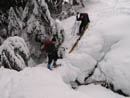
Creek Crossing |
Across The Creek |
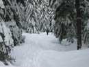
Forest Trail |
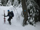
Jim At Work |
Turn Arrow |
More Diamonds |
Photo Page 2
Trips - 2006
Home