6/30 - 7/04/07
Suzanne wanted to get out of town. I had one day to
find a destination. She wanted good weather, minimal snow, and lots of
roaming. We went through a few options and settled on Horseshoe Basin
in the Pasayten Wilderness. Neither of us had been there before. It's
a long drive from Seattle. We met at around 7:00 am on Saturday and soon
were needed north. We chose to drive over via the North Cascades Highway.
It's a little slower but more scenic. It was my second time over the NCH
in a month and also second time ever. We knew that fire last fall burned
much of the approach trail but the basin itself seemed to have escaped
the blaze.
Our approach included a minor route finding error that took us into Oroville via the backroad. Once back on track we reached Loomis and were surprised to see that pavement continued into the high forest. There were only a few short dirt sections of road all the way to the Iron Gate Road junction. The signed turn is just beyond milepost 36. Guide books talk about how bad the 6+ mile road to Iron Gate is. At least for now it is not bad at all.
We arrived at the trailhead a little after 2:00 pm. About 7 hours including our little wild goose chase. It was warm with some clouds. By 2:15 we were on the trail. The route to Sunny Pass is an old road. It is wide and pretty smooth. The start is downhill in forest. In less than a mile is an intersection. Left goes to Windy Peak on the Clutch Creek Trail. Right is the Albert/Fourteen Mile Trail. All three routes can get to Sunny Pass. The straight ahead trail is the shortest way.
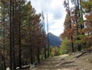
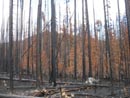
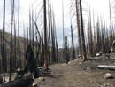
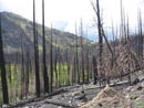
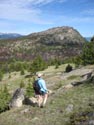
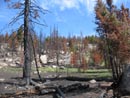
The green forest soon gave way to the burn. Everything is black. The charred remains of trees, stumps, and even much of the ground. It was interesting to see patches of green grasses and low plants. Some life is coming back already. The fire was just last fall. While the devastation is almost complete, it also has a beauty all its own. The crossing of Clutch Creek was the last abundant water supply until near Sunny Pass. The road climbs gently with a few ups and downs. The trailhead is at about 6150' and Sunny Pass is at 7250' leaving a net gain of about 1100'.
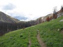
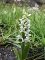
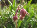
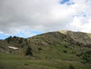
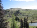
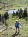
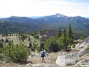
Plants included sage, paintbrush, lupine, shooting stars, bog orchid, old man's whiskers, marsh marigolds, and more. It was not the peak of the flowers but they were very good none the less. Nearing Sunny Pass we went by one camping group. Upon reaching the pass after five miles of hiking everything changed. The charred burn gave way to the rolling grassland and peaks of Horseshoe Basin. What a difference! We could see Pick, Rock, Armstrong, Arnold, and Horseshoe peaks ringing the basin. In the next few days we would be on top of all of them.
From Sunny Pass the route begins a gently descending traverse to the right. We contoured around Horseshoe Mountain. There were still lots of small creeks crossing the trail. By mid summer they will all be dry. We dropped about 200' in 1 1/8 mile to Horseshoe Pass. A sign points right to Smith Lake. We continued ahead a very short distance to another sign for Goodenough Peak. The trail now turns from north to northwest for about a mile to Louden Lake. We crossed one larger creek draining the valley between Armstrong and Arnold Peaks.
After seven miles of hiking we were ready to find a campsite near 7070' Louden Lake. One tent was visible above the southeast end of the lake. Another tent was hidden on the slope of Armstrong across from the lake. After scouting the southwest end of the lake we found one more group of tents and a good available site. The tent went up and the food was hung. We had dinner and walked around the lake area. It was soon time to turn in. I usually sleep poorly the first night out but was so tired I was soon out and slept until morning. Suzanne did likewise.
Day 2
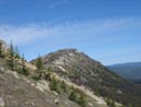
We had no preconceived plans so we made it up as we went along. After breakfast we chose to climb right up from the campsite to the summit of Rock Mountain. The hillside is steep but its mostly grassy with good footing. There was still one snowbank and we passed it on the right. The top proved to be a plateau with several bumps. This is a theme that repeated itself on most of the summits we visited. We had our first long distance views from the 7617' summit. That didn't take long. What to do now? Suzanne suggested dropping down to the northwest and climbing the peak across from us.
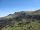
We thought that peak was Haig but in fact it was Point 7784 some 81' lower than Haig. The descent from Rock was easy enough though we did have to avoid some muddy marshy spots. At the bottom was more marsh to get through. We rose to intersect the Boundary Trail coming from Louden Lake. A little more burn was passed and we rose to meadows on the hillside. The going was easy to a ridge. Above was easy scrambling to the summit. The block was too steep on three sides but provided access on the other side. Summit number two was under our belts.
We dropped a little to the west on another summit plateau to a slightly slower summit. We could see a lower ridge heading to the north and into Canada with a point at the end. Suzanne was interested in taking a shot at it. The east side of the ridge below us was impossibly steep. It was not clear if the top was hikable or if we could drop down to the ridge at all. It was soon clear that we could not get straight down to the ridge from the west summit. We headed back east looking for a way down. Before we reached the true summit I saw a gully that would take us down the southwest side to leveler ground below.
We dropped down the gully and traversed downhill to the start of the ridge. We rounded the corner now heading north on the ridge and it was easy going. There were a few ups and downs as we headed along the ridge. We came to a bare spot and a look west showed it was the border swath. No trees at all on the border. We could see it going many miles to the west. A look uphill to the ridge top showed something and we headed up to find Monument 102. We took a few photos and continued north. The final scramble was easy enough and we reached the summit.
The summit appeared to be small from a distance but in fact it was large enough for us and about 90 of our friends. It was a great place to relax and enjoy the view. That's exactly what we did. We had lunch and lazed around for an hour or so. Heading back we chose to stay right on the ridge top and it worked just fine. When we reached Monument 102 I noticed a big bullet hole right through it. Who would go all the way out here to shoot a monument? More importantly, we did not remember seeing it on the way out. Uh oh... We were more than a little disturbed. I immediately thought to check out our earlier photos. Indeed, they did show a bullet hole. We breathed a sigh of relief and continued on.
Instead of going back to the summit we did a level traverse around Point 7784 and dropped back down to the trail. In short order we were back at camp. Since Point 7784 has no official name Suzanne and I dubbed it Sadie's Summit. The northern point out the ridge is Sadie's Tail. The bugs began to make their presence known but were not too bad. It was still early so off we headed again. This time we hiked back to Horseshoe Pass then took the trail towards Smith Lake. There were still a number of creeks crossing this trail. Some snow still lingered on the north side of Horseshoe Mountain.
Along the Smith Lake Trail we saw a number of larch trees. Over the next few days we found a number of areas of larch concentrations. There were also a number of flowers along the trail. We passed two hikers who turned out to the folks we saw camping below Sunny Pass on day one. At Smith Lake we found a group of three campers. The lake itself was larger than Louden but not that impressive.
From there we headed back to camp. After dinner we debated doing one more trip. Although tired we chose to head up Armstrong Mountain. We headed straight up to the sough ridge from Louden Lake. It was moderately steep grass and small rocks. Not difficult but tiring. Once on the ridge the grade lessened and led up to the American summit at the east edge of the peak. Again we found ourselves on a huge summit plateau. We found Monument 104 near the 8140' summit. The Canadian summit appeared to be a little higher and we trudged towards it. It's at least a third of a mile across the plateau.
The sun was now low on the horizon as we found Monument 103, the third one we saw this day. It was about 9:00 pm now. We headed down with a good chance of reaching camp before dark. A little way down the slope I noticed an interesting cloud to the south and mentioned it to Suzanne. She stopped and looked around seeing a blazing red cloud to the west. Neither of us had seen it. It was amazing. Suzanne took off to the west to see over the ridge. I followed. We came to a point with a great view of the sunset.
This may have been the best sunset I have ever seen. Wow! It started red and soon became much redder. There were just enough clouds to create some amazing colors. Three dozen photos later the colors faded and the sun set. We sped up and hurried down the slope and back to camp. Thus ended a spectacular day of hiking.
Day 3
Our third day began with another peak to bag. We headed back to the south ridge of Armstrong at a lower angle. Crossing the ridge we dropped into the valley between Armstrong and Arnold peaks. The low point between the peaks is Soehumption Gap. We headed towards the gap but turned uphill before reaching it. The middle of the valley was very marshy. We slogged through a little mud before getting across. The slope looked very steep but proved to be easy enough to hike up. I was tired from the first two days and made slow steady progress.
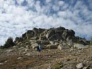
As the grade lessened we found...another long flat summit plateau. The actual 8090' summit was marked by a rock wall that was visible from far away. From the top we could see wide rounded ridges going off to the east and northeast. We dropped a few hundred feet down the northeast ridge. One could just walk on and on and on... We on the other had had other places to go. We headed back the way we came. This time we headed down near the gap and then dropped down the valley, over the ridge of Armstrong, and back to camp.
It was now time to pack up and move camp. We planned to head back to Sunny Pass for the last two nights. It was very warm this day. It is only a few miles to the pass with a few hundred feet to gain. As we approached Sunny Pass I saw a hiker and a dog above the trail. I recognized them as Slugman and Daisy! I had met Slugman before but Suzanne only knew him from nwhikers.net postings. We had a nice exchange and he suggested an area to find good camps. We followed his advice and found a nice spot above the trail.
We hoped a high camp would have wind as the bugs became much worse each day. We set up camp, hung the food, and packed up for another day hike. This time the destination was 7956' Horseshoe Mountain. The slope was easy enough to ascend but we found ourselves meeting the Albert/Fourteen Mile Trail and used it to climb on up. It is very easily graded with many switchbacks. When it reached the south ridge of Horseshoe we turned towards the summit. We found....yet another long gentle summit plateau. Clouds had been building all day and now they were getting dark.
We were still in shorts and short sleeves though a cold wind was blowing. We reached the summit and very soon were heading back down. We felt a few raindrops. They were the only ones for the whole trip and lasted only a minute or two. Our route down was more direct and soon we were back at camp. It was time for dinner. After that the bugs drove us indoors. My Nallo 3 is plenty big for two.
Although we were both tired 7620' Pick Peak is only 450' above our campsite. At around 8:00 pm we headed up for another sunset view. We reached the peak quickly. The mosquitoes were bugging us so we headed down the west ridge of Pick. It was yet another broad grassy gently sloping ridge. We dropped a few hundred feet then headed back uphill. On the summit we had a good though not great sunset. The hike down to camp was fast and we headed to bed.
Day 4
Day four took us west and out of Horseshoe Basin. Windy Peak is the highest point in the area nearby. At 8334' it is only 1130' above Sunny Pass. To get there you have to drop 650' though. The trail left right from Sunny Pass and began to descend. Before long we left green forest and entered a very severe burn from last fall. Charred remains of trees are all around. It was already warm at 9:00 am and getting warmer. Going downhill was easy but tired legs were not very happy with the uphill. We could see a pass to the north of Windy and expected the trail to go there.
The trail contoured above the bottom of the valley and climbed in charred trees. It went to the south of the pass. Green forest began again and now it was largely larch trees. We came to an intersection. Left went to Windy Peak and right to Chewack River. We went left and continued climbing. The route went to the east of a large bump on the ridge. It then went behind another bump on the west and regained the ridge top. From there is climbed bard slopes to traverse around the west side of Windy Peak.
We hiked up this trail and on the west side of the summit we found three packs along the trail. The map shows a way trail to the summit but we saw no trail here. I suggested just heading up the slope. We did so and traversed a little south as we climbed up. A few minutes later I saw a women hiking down. In fact she was on the summit trail. It was the group we saw at Smith Lake. They were hiking out via the Clutch Creek Trail.
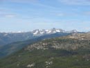
Now on trail we had no problems reaching the old lookout site on the summit. The view from on top was outstanding. We could see Glacier Peak and the top of Mt. Baker far to the west. It was such a nice summit that we chose to have an extended stay. We could see that Topaz Mountain was just off the Chewack River Trail and not far from the intersection. It was not possible to see if the ridge could be scrambled but we considered giving it a try.
On the way down we followed the summit trail to a well signed intersection. We then followed our way back to the Chewack intersection. I was tired but Topaz was close by so off we went. The route dropped down to the obvious saddle then climbed up the ridge of Topaz. We left the trail and followed the broad grassy ridge. It did not take long to get to the summit block. The right side looked to have loose dirt and very steep rock. The ridge itself was too steep. The left side looked better though it burned all the way to the summit.
Off to the left we went. It wa mostly dirt down low and rock above. I headed up first. Half way up I spotted a possible route to our left. Climbing up I found that there was a wide ramp with rock on either side. This passage switched back and another ramp led to the top. It was a very unlikely near walk up. Suzanne followed and we were on top in no time. There are actually four summits. The second was higher than the first. The map shows this one to be the highest. I found a buck knife near the top. We had a short stay on top and headed down.
The three others we saw on Windy mentioned they camped at Windy Lake. We chose to try finding it ourselves on the way down. It's obvious enough from the map where to leave the trail. In fact we found a boot path to the lake. The burn reached the lake and it is well charred on several sides. There are a few camp spots but others are now very ashy. Back on trail we dropped down through the burn.
It was getting very warm and the burn seemed like something out of Dante's Inferno. Suzanne called it "Hell Canyon". It was very appropriate. The last 500' of gain seemed to take forever. Finally back at camp the mosquitoes were now getting down right voracious. We headed indoors again for a nap. After dinner we headed back up Pick Peak for our third straight mountain top sunset. Better than number two but nowhere near as good as the first one. Bugs were really bad on the summit of Pick at 9:00 pm. Thus ended another day in Horseshoe Basin.
Day 5
The final day began with breakfast and then we packed up to leave. With much food weight gone our packs were much lighter. The trip down went very fast. We were on the trail at 7:40 and reached the car at 9:10. That just left a six hour drive home via Highways 97 and 90. It may not be shorter than Highway 20 but it is faster. By the time we reached Loomis it was in the 70s. By the time we reached Cle Elum it was 97 degrees. I was happy to be leaving as the temperatures began to soar.
This was a trip I had planned for many years. It came about unexpectedly but was every bit as good as I could have hoped for. The fire did scar the area around the basin but the basin itself was untouched. We camped each night above 7000' and summited seven named peaks and two unnamed ones. Three peaks were over 8000' and the others were over 7600'. We saw a lot of the area but now I am even more intrigued with the things we did not see. Cathedral Pass, Haig Mountain, Teapot Dome, and Amphitheater Mountain. Perhaps a fall trip to see the larch. I will be back.
Suzanne's trip report and photos are here: Nwhikers Report
Click on thumbnails to get larger pictures.
Photo Page 2
Trips - 2007
Home
Our approach included a minor route finding error that took us into Oroville via the backroad. Once back on track we reached Loomis and were surprised to see that pavement continued into the high forest. There were only a few short dirt sections of road all the way to the Iron Gate Road junction. The signed turn is just beyond milepost 36. Guide books talk about how bad the 6+ mile road to Iron Gate is. At least for now it is not bad at all.
We arrived at the trailhead a little after 2:00 pm. About 7 hours including our little wild goose chase. It was warm with some clouds. By 2:15 we were on the trail. The route to Sunny Pass is an old road. It is wide and pretty smooth. The start is downhill in forest. In less than a mile is an intersection. Left goes to Windy Peak on the Clutch Creek Trail. Right is the Albert/Fourteen Mile Trail. All three routes can get to Sunny Pass. The straight ahead trail is the shortest way.
The green forest soon gave way to the burn. Everything is black. The charred remains of trees, stumps, and even much of the ground. It was interesting to see patches of green grasses and low plants. Some life is coming back already. The fire was just last fall. While the devastation is almost complete, it also has a beauty all its own. The crossing of Clutch Creek was the last abundant water supply until near Sunny Pass. The road climbs gently with a few ups and downs. The trailhead is at about 6150' and Sunny Pass is at 7250' leaving a net gain of about 1100'.
Plants included sage, paintbrush, lupine, shooting stars, bog orchid, old man's whiskers, marsh marigolds, and more. It was not the peak of the flowers but they were very good none the less. Nearing Sunny Pass we went by one camping group. Upon reaching the pass after five miles of hiking everything changed. The charred burn gave way to the rolling grassland and peaks of Horseshoe Basin. What a difference! We could see Pick, Rock, Armstrong, Arnold, and Horseshoe peaks ringing the basin. In the next few days we would be on top of all of them.
From Sunny Pass the route begins a gently descending traverse to the right. We contoured around Horseshoe Mountain. There were still lots of small creeks crossing the trail. By mid summer they will all be dry. We dropped about 200' in 1 1/8 mile to Horseshoe Pass. A sign points right to Smith Lake. We continued ahead a very short distance to another sign for Goodenough Peak. The trail now turns from north to northwest for about a mile to Louden Lake. We crossed one larger creek draining the valley between Armstrong and Arnold Peaks.
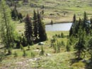
After seven miles of hiking we were ready to find a campsite near 7070' Louden Lake. One tent was visible above the southeast end of the lake. Another tent was hidden on the slope of Armstrong across from the lake. After scouting the southwest end of the lake we found one more group of tents and a good available site. The tent went up and the food was hung. We had dinner and walked around the lake area. It was soon time to turn in. I usually sleep poorly the first night out but was so tired I was soon out and slept until morning. Suzanne did likewise.
Day 2
We had no preconceived plans so we made it up as we went along. After breakfast we chose to climb right up from the campsite to the summit of Rock Mountain. The hillside is steep but its mostly grassy with good footing. There was still one snowbank and we passed it on the right. The top proved to be a plateau with several bumps. This is a theme that repeated itself on most of the summits we visited. We had our first long distance views from the 7617' summit. That didn't take long. What to do now? Suzanne suggested dropping down to the northwest and climbing the peak across from us.
We thought that peak was Haig but in fact it was Point 7784 some 81' lower than Haig. The descent from Rock was easy enough though we did have to avoid some muddy marshy spots. At the bottom was more marsh to get through. We rose to intersect the Boundary Trail coming from Louden Lake. A little more burn was passed and we rose to meadows on the hillside. The going was easy to a ridge. Above was easy scrambling to the summit. The block was too steep on three sides but provided access on the other side. Summit number two was under our belts.
We dropped a little to the west on another summit plateau to a slightly slower summit. We could see a lower ridge heading to the north and into Canada with a point at the end. Suzanne was interested in taking a shot at it. The east side of the ridge below us was impossibly steep. It was not clear if the top was hikable or if we could drop down to the ridge at all. It was soon clear that we could not get straight down to the ridge from the west summit. We headed back east looking for a way down. Before we reached the true summit I saw a gully that would take us down the southwest side to leveler ground below.
We dropped down the gully and traversed downhill to the start of the ridge. We rounded the corner now heading north on the ridge and it was easy going. There were a few ups and downs as we headed along the ridge. We came to a bare spot and a look west showed it was the border swath. No trees at all on the border. We could see it going many miles to the west. A look uphill to the ridge top showed something and we headed up to find Monument 102. We took a few photos and continued north. The final scramble was easy enough and we reached the summit.
The summit appeared to be small from a distance but in fact it was large enough for us and about 90 of our friends. It was a great place to relax and enjoy the view. That's exactly what we did. We had lunch and lazed around for an hour or so. Heading back we chose to stay right on the ridge top and it worked just fine. When we reached Monument 102 I noticed a big bullet hole right through it. Who would go all the way out here to shoot a monument? More importantly, we did not remember seeing it on the way out. Uh oh... We were more than a little disturbed. I immediately thought to check out our earlier photos. Indeed, they did show a bullet hole. We breathed a sigh of relief and continued on.
Instead of going back to the summit we did a level traverse around Point 7784 and dropped back down to the trail. In short order we were back at camp. Since Point 7784 has no official name Suzanne and I dubbed it Sadie's Summit. The northern point out the ridge is Sadie's Tail. The bugs began to make their presence known but were not too bad. It was still early so off we headed again. This time we hiked back to Horseshoe Pass then took the trail towards Smith Lake. There were still a number of creeks crossing this trail. Some snow still lingered on the north side of Horseshoe Mountain.
Along the Smith Lake Trail we saw a number of larch trees. Over the next few days we found a number of areas of larch concentrations. There were also a number of flowers along the trail. We passed two hikers who turned out to the folks we saw camping below Sunny Pass on day one. At Smith Lake we found a group of three campers. The lake itself was larger than Louden but not that impressive.
From there we headed back to camp. After dinner we debated doing one more trip. Although tired we chose to head up Armstrong Mountain. We headed straight up to the sough ridge from Louden Lake. It was moderately steep grass and small rocks. Not difficult but tiring. Once on the ridge the grade lessened and led up to the American summit at the east edge of the peak. Again we found ourselves on a huge summit plateau. We found Monument 104 near the 8140' summit. The Canadian summit appeared to be a little higher and we trudged towards it. It's at least a third of a mile across the plateau.
The sun was now low on the horizon as we found Monument 103, the third one we saw this day. It was about 9:00 pm now. We headed down with a good chance of reaching camp before dark. A little way down the slope I noticed an interesting cloud to the south and mentioned it to Suzanne. She stopped and looked around seeing a blazing red cloud to the west. Neither of us had seen it. It was amazing. Suzanne took off to the west to see over the ridge. I followed. We came to a point with a great view of the sunset.
This may have been the best sunset I have ever seen. Wow! It started red and soon became much redder. There were just enough clouds to create some amazing colors. Three dozen photos later the colors faded and the sun set. We sped up and hurried down the slope and back to camp. Thus ended a spectacular day of hiking.
Day 3
Our third day began with another peak to bag. We headed back to the south ridge of Armstrong at a lower angle. Crossing the ridge we dropped into the valley between Armstrong and Arnold peaks. The low point between the peaks is Soehumption Gap. We headed towards the gap but turned uphill before reaching it. The middle of the valley was very marshy. We slogged through a little mud before getting across. The slope looked very steep but proved to be easy enough to hike up. I was tired from the first two days and made slow steady progress.
As the grade lessened we found...another long flat summit plateau. The actual 8090' summit was marked by a rock wall that was visible from far away. From the top we could see wide rounded ridges going off to the east and northeast. We dropped a few hundred feet down the northeast ridge. One could just walk on and on and on... We on the other had had other places to go. We headed back the way we came. This time we headed down near the gap and then dropped down the valley, over the ridge of Armstrong, and back to camp.
It was now time to pack up and move camp. We planned to head back to Sunny Pass for the last two nights. It was very warm this day. It is only a few miles to the pass with a few hundred feet to gain. As we approached Sunny Pass I saw a hiker and a dog above the trail. I recognized them as Slugman and Daisy! I had met Slugman before but Suzanne only knew him from nwhikers.net postings. We had a nice exchange and he suggested an area to find good camps. We followed his advice and found a nice spot above the trail.
We hoped a high camp would have wind as the bugs became much worse each day. We set up camp, hung the food, and packed up for another day hike. This time the destination was 7956' Horseshoe Mountain. The slope was easy enough to ascend but we found ourselves meeting the Albert/Fourteen Mile Trail and used it to climb on up. It is very easily graded with many switchbacks. When it reached the south ridge of Horseshoe we turned towards the summit. We found....yet another long gentle summit plateau. Clouds had been building all day and now they were getting dark.
We were still in shorts and short sleeves though a cold wind was blowing. We reached the summit and very soon were heading back down. We felt a few raindrops. They were the only ones for the whole trip and lasted only a minute or two. Our route down was more direct and soon we were back at camp. It was time for dinner. After that the bugs drove us indoors. My Nallo 3 is plenty big for two.
Although we were both tired 7620' Pick Peak is only 450' above our campsite. At around 8:00 pm we headed up for another sunset view. We reached the peak quickly. The mosquitoes were bugging us so we headed down the west ridge of Pick. It was yet another broad grassy gently sloping ridge. We dropped a few hundred feet then headed back uphill. On the summit we had a good though not great sunset. The hike down to camp was fast and we headed to bed.
Day 4
Day four took us west and out of Horseshoe Basin. Windy Peak is the highest point in the area nearby. At 8334' it is only 1130' above Sunny Pass. To get there you have to drop 650' though. The trail left right from Sunny Pass and began to descend. Before long we left green forest and entered a very severe burn from last fall. Charred remains of trees are all around. It was already warm at 9:00 am and getting warmer. Going downhill was easy but tired legs were not very happy with the uphill. We could see a pass to the north of Windy and expected the trail to go there.
The trail contoured above the bottom of the valley and climbed in charred trees. It went to the south of the pass. Green forest began again and now it was largely larch trees. We came to an intersection. Left went to Windy Peak and right to Chewack River. We went left and continued climbing. The route went to the east of a large bump on the ridge. It then went behind another bump on the west and regained the ridge top. From there is climbed bard slopes to traverse around the west side of Windy Peak.
We hiked up this trail and on the west side of the summit we found three packs along the trail. The map shows a way trail to the summit but we saw no trail here. I suggested just heading up the slope. We did so and traversed a little south as we climbed up. A few minutes later I saw a women hiking down. In fact she was on the summit trail. It was the group we saw at Smith Lake. They were hiking out via the Clutch Creek Trail.
Now on trail we had no problems reaching the old lookout site on the summit. The view from on top was outstanding. We could see Glacier Peak and the top of Mt. Baker far to the west. It was such a nice summit that we chose to have an extended stay. We could see that Topaz Mountain was just off the Chewack River Trail and not far from the intersection. It was not possible to see if the ridge could be scrambled but we considered giving it a try.
On the way down we followed the summit trail to a well signed intersection. We then followed our way back to the Chewack intersection. I was tired but Topaz was close by so off we went. The route dropped down to the obvious saddle then climbed up the ridge of Topaz. We left the trail and followed the broad grassy ridge. It did not take long to get to the summit block. The right side looked to have loose dirt and very steep rock. The ridge itself was too steep. The left side looked better though it burned all the way to the summit.
Off to the left we went. It wa mostly dirt down low and rock above. I headed up first. Half way up I spotted a possible route to our left. Climbing up I found that there was a wide ramp with rock on either side. This passage switched back and another ramp led to the top. It was a very unlikely near walk up. Suzanne followed and we were on top in no time. There are actually four summits. The second was higher than the first. The map shows this one to be the highest. I found a buck knife near the top. We had a short stay on top and headed down.
The three others we saw on Windy mentioned they camped at Windy Lake. We chose to try finding it ourselves on the way down. It's obvious enough from the map where to leave the trail. In fact we found a boot path to the lake. The burn reached the lake and it is well charred on several sides. There are a few camp spots but others are now very ashy. Back on trail we dropped down through the burn.
It was getting very warm and the burn seemed like something out of Dante's Inferno. Suzanne called it "Hell Canyon". It was very appropriate. The last 500' of gain seemed to take forever. Finally back at camp the mosquitoes were now getting down right voracious. We headed indoors again for a nap. After dinner we headed back up Pick Peak for our third straight mountain top sunset. Better than number two but nowhere near as good as the first one. Bugs were really bad on the summit of Pick at 9:00 pm. Thus ended another day in Horseshoe Basin.
Day 5
The final day began with breakfast and then we packed up to leave. With much food weight gone our packs were much lighter. The trip down went very fast. We were on the trail at 7:40 and reached the car at 9:10. That just left a six hour drive home via Highways 97 and 90. It may not be shorter than Highway 20 but it is faster. By the time we reached Loomis it was in the 70s. By the time we reached Cle Elum it was 97 degrees. I was happy to be leaving as the temperatures began to soar.
This was a trip I had planned for many years. It came about unexpectedly but was every bit as good as I could have hoped for. The fire did scar the area around the basin but the basin itself was untouched. We camped each night above 7000' and summited seven named peaks and two unnamed ones. Three peaks were over 8000' and the others were over 7600'. We saw a lot of the area but now I am even more intrigued with the things we did not see. Cathedral Pass, Haig Mountain, Teapot Dome, and Amphitheater Mountain. Perhaps a fall trip to see the larch. I will be back.
Suzanne's trip report and photos are here: Nwhikers Report
Entering Burn |
Black & Orange |
Meadow |
Thoroughly Burned |
Green |
Orchid |
Old Man's Whiskers |
Near Sunny Pass |
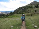
Suzanne At Sunny |
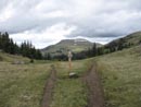
Intersection |
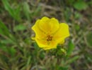
Yellow Flower |
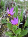
Shooting Stars |
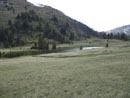
Louden Lake |
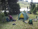
Camp Site |
Heading Up |
Armstrong Mountain |
Ascending Rock Mt |
Point 7784 |
Armstrong Meadow |
Rock False Summit |
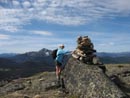
Rock Cairn |
Cathedral Peak |
Route Next |
Point 7784 Burn |
Climbing 7784 |
Photo Page 2
Trips - 2007
Home