3-25-07
Red Mountain, near Salmon La Sac, is a scramble summit
I had long planned to visit. It turned out to be on a winter scramble.
A group put the trip together and Bob and Kolleen signed on. I found out
late in the week that I was free to go and tagged along. We met in Bellevue
at 6:15 AM. Way too early but it did allow us to get home early. We met
the group at the Last Resort near Lake Cle Elum. The resort now has a new
name but everyone managed to find it. We then headed on to the start at the
start of the Cooper Lake Road. By 8:30 we were on our way.
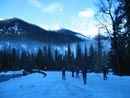
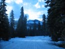
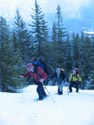
Saturday it rained non stop and one reason we headed so far east was to try to find some blue sky. In fact it was partly sunny when we started. The first 1.6 miles is along the road. It is groomed for snowmobiles and easy walking. Even with the rain and warmth the day before the snow was hard enough to allow for good speed. The bridge at the start gave us a view of the summit 3450' above.
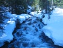
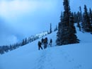
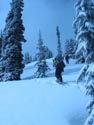
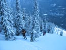
With clothing breaks and photo opportunities it took us 45 minutes to reach the summer trailhead. At this point we put on snowshoes and headed off the road. The summer trail follows the left side of a creek, crosses it and climbs to a basin below the summit. We chose to angle a little right and onto a ridge. The ridge continues all the way up to the summit.
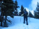
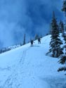
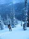
The snow was hard enough to make for good traction. After a gentle beginning we began the steeper climb. Erin was in the lead most of the way. She did not seem to have any gear other than full speed. The group was pretty strong as everyone managed to keep up fairly well. After gaining about 1000' from the road we ran into a logging road. It was the only flat spot for al long time. The sun was now fully out and it was getting pretty warm. I was regretting wearing soft shell pants and had rolled up my sleeves.
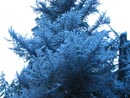
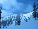
A little higher we stopped on the steep slope for a food break. It began to snow lightly while still bright and sunny. Spring is always interesting. Another 500' of climbing and the grade began to lessen. The wide ridge also began to narrow down. The steeper part was in forest with well spaced trees. Higher up the trees were closer spaced. We had to squeeze between trees in a few spots.
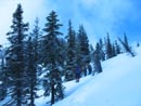
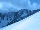
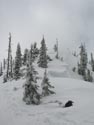
The gentle ridge gave way to one more climb to the top. Views also began but clouds were now closing in. We could see most of Davis Peak but the summit was in the clouds. Cooper Lake was in the clear as we had a view over the other side of the ridge. We could see the basin below us and the ridge on the other side of the basin. That was a possible route for our descent.
We stayed well left of cornices on the ridge and climbed up the last steeper 500' to the summit. Red Mountain has two summits over 5800'. It's hard to tell which one is higher. We stopped on the first summit for more food then dropped down and followed the ridge a short way to the other summit. There were several good sized cornices along this ridge. We could see Cathedral Rock but not Mt. Daniel. The tops of all the Cascade Crest peaks were in the clouds. It was mostly cloudy now but we did manage to avoid any rain.
Now came another decision. Retrace our steps are follow the ridge around the basin and take one of several other ridges down to the road. Getting off the summit was not an easy walk and there are a few high points on the ridge to get over or around. The group chose to split. Matt and four others chose to explore the ridge and find another way down. The other six of us chose to retrace our route up.
It took us 3 1/2 hours coming up. The descent was much faster. The snow had softened considerably since our ascent. I was sinking quite a bit in places though it was harder in the trees. We took out our ice axes for the first part then went back to poles. We worked our way down following our uphill tracks. After dropping about half way most of us took off our snowshoes. Plunge stepping proved to be easier. When the ridge ended the snow was pretty soft on the flats.
I was sinking knee deep on most steps but I couldn't be bothered putting snowshoes back on. At long last we reached the road. It took an hour less to descend than ascend. The road was a bit softer but still hard enough to allow walking without snowshoes. That last 1.6 miles seemed to go on forever. It took us a full 40 minutes to get back to the cars.
This turned out to be a fun scramble. We had a good and strong group. The route was steep but not exposed. Gaining 3100' in two miles was a very good workout. Even the weather cooperated. The summit is a very good vantage point. It has a clear look at the Cascade Crest peaks, the Teanaway peaks, and Mt. Hinman and Daniel. Now I just need to get up there on a perfectly clear day. All the more reason to make a return visit.
Click on thumbnails to get larger pictures.
Photo Page 2
Trips - 2007
Home
Saturday it rained non stop and one reason we headed so far east was to try to find some blue sky. In fact it was partly sunny when we started. The first 1.6 miles is along the road. It is groomed for snowmobiles and easy walking. Even with the rain and warmth the day before the snow was hard enough to allow for good speed. The bridge at the start gave us a view of the summit 3450' above.
With clothing breaks and photo opportunities it took us 45 minutes to reach the summer trailhead. At this point we put on snowshoes and headed off the road. The summer trail follows the left side of a creek, crosses it and climbs to a basin below the summit. We chose to angle a little right and onto a ridge. The ridge continues all the way up to the summit.
The snow was hard enough to make for good traction. After a gentle beginning we began the steeper climb. Erin was in the lead most of the way. She did not seem to have any gear other than full speed. The group was pretty strong as everyone managed to keep up fairly well. After gaining about 1000' from the road we ran into a logging road. It was the only flat spot for al long time. The sun was now fully out and it was getting pretty warm. I was regretting wearing soft shell pants and had rolled up my sleeves.
A little higher we stopped on the steep slope for a food break. It began to snow lightly while still bright and sunny. Spring is always interesting. Another 500' of climbing and the grade began to lessen. The wide ridge also began to narrow down. The steeper part was in forest with well spaced trees. Higher up the trees were closer spaced. We had to squeeze between trees in a few spots.
The gentle ridge gave way to one more climb to the top. Views also began but clouds were now closing in. We could see most of Davis Peak but the summit was in the clouds. Cooper Lake was in the clear as we had a view over the other side of the ridge. We could see the basin below us and the ridge on the other side of the basin. That was a possible route for our descent.
We stayed well left of cornices on the ridge and climbed up the last steeper 500' to the summit. Red Mountain has two summits over 5800'. It's hard to tell which one is higher. We stopped on the first summit for more food then dropped down and followed the ridge a short way to the other summit. There were several good sized cornices along this ridge. We could see Cathedral Rock but not Mt. Daniel. The tops of all the Cascade Crest peaks were in the clouds. It was mostly cloudy now but we did manage to avoid any rain.
Now came another decision. Retrace our steps are follow the ridge around the basin and take one of several other ridges down to the road. Getting off the summit was not an easy walk and there are a few high points on the ridge to get over or around. The group chose to split. Matt and four others chose to explore the ridge and find another way down. The other six of us chose to retrace our route up.
It took us 3 1/2 hours coming up. The descent was much faster. The snow had softened considerably since our ascent. I was sinking quite a bit in places though it was harder in the trees. We took out our ice axes for the first part then went back to poles. We worked our way down following our uphill tracks. After dropping about half way most of us took off our snowshoes. Plunge stepping proved to be easier. When the ridge ended the snow was pretty soft on the flats.
I was sinking knee deep on most steps but I couldn't be bothered putting snowshoes back on. At long last we reached the road. It took an hour less to descend than ascend. The road was a bit softer but still hard enough to allow walking without snowshoes. That last 1.6 miles seemed to go on forever. It took us a full 40 minutes to get back to the cars.
This turned out to be a fun scramble. We had a good and strong group. The route was steep but not exposed. Gaining 3100' in two miles was a very good workout. Even the weather cooperated. The summit is a very good vantage point. It has a clear look at the Cascade Crest peaks, the Teanaway peaks, and Mt. Hinman and Daniel. Now I just need to get up there on a perfectly clear day. All the more reason to make a return visit.
Getting Started |
Groomed Road |
Creek |
Uphill |
Bob & Tom |
Snowy Tree |
More Open |
Up The Ridge |
Hard Snow |
Across Basin |
South Summit |
Carol |
Kolleen & Matt |
Valley Far Below |
North Summit |
Photo Page 2
Trips - 2007
Home