8-18-07
An incoming summer storm caused us to change our backpacking
plans. Instead, Gary, Mark, and I chose to head east for clearer weather.
We chose a trip that none of us had ever done. I did snowshoe up Red Mountain
last winter but it was from the north side. This time we would be coming
up from the south. We drove to the north end of Lake Cle Elum then turned
left. The gravel road has some washboard but is in pretty good shape. We
reached the Thorp Lake trailhead, got ready, and were on our way by 9:30 am.
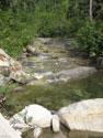
The gated road drops to an immediate crossing of Thorp Creek. The bridge is gone. There is a sign at the the trailhead stating it will be replaced this summer. The creek is low and is an easy rock hop now. The road then turns right and left. There is a sign showing right to Little Joe Lake and left to Thorp Lake. We chose to do the loop counter clockwise so we headed right.
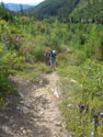
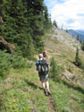
The old road comes to Little Joe's outlet creek. The bridge is gone. With low water it is easy to cross. A marked turn off then heads steeply uphill. This section of trail starts steep but is in fairly good shape. There are some switchbacks. The lower part has some very ripe huckleberries. They were the best ones I've had so far this year. The trailhead is at about 3500'. Little Joe Lake is at about 5700'. It's 1 1/2 miles to the lake and almost all of the 1200' gain is after crossing Little Joe Creek. It does not feel like it is that steep.
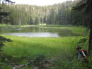
The way becomes less steep, crosses the creek and soon reaches Little Joe Lake. It was sunny and warm. We took a break at the lake. It is fairly small and one end is turning grassy. Back on our way, we reached trail signs at the northeast end of the lake. To the left is the Red Mountain Trail heading towards Kachess Ridge. Right is the continuation of the Red Mountain Trail up over the ridge of Red and down to the Cooper Lake Road. I was not expecting this old trail to be signed.
The Red Mountain Trail from near Kachess Ridge to the basin north of Red Mountain does not show on most maps. We had one map that showed it going from the south side of the lake. Another showed it going by half way up the ridge to the north. In fact it is misplaced on both maps. The route gains 1000' to the ridge of Red. It was in much better shape than I expected. There were a couple places where it was minimal but overall it was fine.
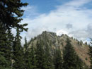
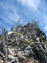
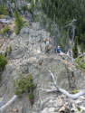
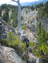
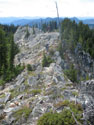
We found only a handful of downed trees from the start to the ridge of Red. Some logs had been freshly cut. Once on the ridge we continued to follow trail as it headed north. The trail reached rock and became a bit of a scramble. There was some blasting and the route was not hard. It wound over and around the ridge top taking us up to the old lookout site. The lookout had a short life. It was built in the 30s and removed in 1948. There is a nice flat spot, remnants of the phone line, cables, and a little glass.
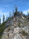
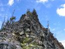
The ridge looked to be a little more interesting farther north. We headed on soon reaching a saddle where the ridge climbs steeply towards the real summit. Mark climbed about half way up the ridge and found more exposure above than he liked. He came down and we tried crossing below the summit. We managed to cross part way across the steep slope. Again, it did not look to be a reasonable route. We headed back to the saddle.
I decided to take a look at the ridge route. I climbed up to where Mark had been. There was a six foot vertical step. There were some minimal footholds but no good hand holds. I think I could have made it up but not necessarily down. I went back to the ridge and climbed a little higher but the exposure to my right was truly impressive. I had had enough and headed back down.
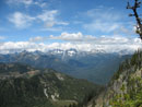
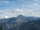
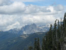
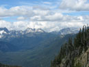
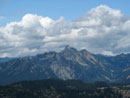
The summit was a whole lot easier from the north on snowshoes. We returned to the lookout site and had our lunch. The views are excellent. We had a close up look at peaks of the Cascade crest. Mt. Stuart was also cloud free. Clouds were pushing over the crest from the west. We pulled out maps and considered going down cross country vs. retracing our steps to Little Joe Lake. A ridge drops to the west and reaches a saddle just above the lake. We decided to give it a shot and try to connect with the trail to the west of the lake.
The ridge decent began easily to a minor saddle then dropped more steeply. We found some animal trails and what appeared to be actual tread in places. We were quite surprised to see some stumps and logging slash right on the ridgge nowhere near any clear cuts. We did fine for the most part and reached the saddle above the lake with no problems. The ridge is fairly steep near the bottom but not that bad. We followed the ridge higher and that proved to be a mistake. We reached the ridge top again with only two options. We could do a long traverse on steep grass or drop straight down. We chose the latter.
From the 5050' pass we ended up gaining 350' then dropping 600'. At 4800' we found the trail. The trail crossed a grassy meadow 50' farther along. If we had dropped accross it we would not have seen the trail. It was about non existant across the meadow then picked up again. I had read that the Red Mountain Trail from Little Joe Lake to Kachess Ridge has many ups and down. I can veify that it does.
We went up 150' then down then up then down. It really added up. The route itself is mostly in better condition than I expected. It is not overgrown and is obvious everywhere except for a few short meadow crossings. We also found more flowers than I would have expected. They were well past their peak but color still is evident. Our sunny moring was rapidly becoming totally overcast. It was getting cooler and darker though it was still mid afternoon.
The trail came to a fork. The left fork was blocked by branches. We headed right. Soom we reached a campsite and a rige top. The trail petered out though we had a four way intersection of minor trails. Out came the maps again. We figured out where we were and it became clear we had to go back. A few minutes later there was an uphill swichback we had not seen. We put branches over the wrong route and continued on.
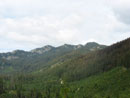
More ups and downs and a logging road came into view below us. Beyond it was No Name Ridge, the continuation of Kaschess Ridge. The trail came to a pass where the logging road ends. All vegetation was oblilerated for a logging landing. Across the saddle the trail picked up once again. Now the trail began a rising traverse to the south. We reached the ridge top and a trail intersection. Four miles north is the Cooper Pass trailhead. 2 1/2 miles south is Thorp Mountain. After a short break we were on our way south.
The ridge top has some steep ups and downs. I was pleased to see that the trail leaves the crest and contours along the east side. It is much more level than the ridge. At times we were at least 100' below the top. It was not flat though as we still had more ups and downs. We crossed one meadon of paintbrush and another of pearly everlasting. Sooner than expected we reached the next intersection. There is a sign laying on the ground. It points downhill signed Thorp Lake and north signed Cooper Pass. It does not show the way to the Thorp Mountain Lookout.
We met the first people of the day here. They were heading north looking for the lookout. We pointed out their error and turned them around. Gary did not remember ever seeing the lookout. Mark had been to the lookout a number of times. I went there via Knox Creek in 1990 but had not been back in 17 years. Gary and I decided to go for the lookout while Mark was happy to take a break and wait for us. It is only about 1/2 mile to the lookout but gains 700'. It's all good trail but is obviously steep.
We had already gained 3900' and such a steep climb so late in the day was a challenge. We caught up with the other guys who were resting. They took off after we passed and we sped up to try to stay ahead. We were about shot when we reached the top. Much to our surprise, the lookout is undergoing a total rebuild. A helicopter drop brought in a generator, piles of wood, power and hand tools, along with 120 gallons of water. A couple are staying ther and doing the work.
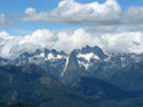
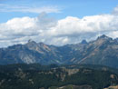
The lookout was in poor shape and will be getting new siding, a roof, and even a deck where none was previously. A big job but it should be in great shape when they are done. It was much colder on top. We put on long sleeves and even gloves. A cold breeze blew though. Really nice views from the lookout. Red Mountain seemed to be a long ways away. Daniel, Hinman, and Cathedral Rock were to the north. Hibox and Three Queens were west with Mineral Creek between them. This is one of the few places where I could see all three peaks of Three Queens.
It was near 5:00 now and we had an early dinner, finishing off most of our food. The drop back to the intersection went fast. We met Mark and began the last 3+ mile slog. We saw Thorp Lake from the summit and soon reached the side trail down to it. The main trail is in fine shape though a bit dusty and rocky in places. At long last we completed our loop, crossed the creek and reached the car.
It was a long day. From 9:30 in the morning to 6:30 in the evening. We had dinner in Rosalyn and I made it home a little after 10:00 pm. It was fun to hike a trail that none of us had ever been on. It was the first time I have ever visited two lookout sites in one day. The Thorp Lookout construction was a real surprise. It was only 2350 from the trailhead to the highpoint of the day but we ended up covering 13 miles with 4700' gained. Two summits and a lot of ups and downs really added up.
The Red Mountain Trail is not well known. It is in the Loop Trails book but otherwise had little publicity. It is not even on USGS maps. What it needs is more feet. The route is not in bad shape but more feet would make it easier to follow in spots. It is a very nice loop with the Thorp Mountain side trip. If you are really ready for a challenge add Red Mountain as well.
Click on thumbnails to get larger pictures.
Photo Page 2
Trips - 2007
Home
The gated road drops to an immediate crossing of Thorp Creek. The bridge is gone. There is a sign at the the trailhead stating it will be replaced this summer. The creek is low and is an easy rock hop now. The road then turns right and left. There is a sign showing right to Little Joe Lake and left to Thorp Lake. We chose to do the loop counter clockwise so we headed right.
The old road comes to Little Joe's outlet creek. The bridge is gone. With low water it is easy to cross. A marked turn off then heads steeply uphill. This section of trail starts steep but is in fairly good shape. There are some switchbacks. The lower part has some very ripe huckleberries. They were the best ones I've had so far this year. The trailhead is at about 3500'. Little Joe Lake is at about 5700'. It's 1 1/2 miles to the lake and almost all of the 1200' gain is after crossing Little Joe Creek. It does not feel like it is that steep.
The way becomes less steep, crosses the creek and soon reaches Little Joe Lake. It was sunny and warm. We took a break at the lake. It is fairly small and one end is turning grassy. Back on our way, we reached trail signs at the northeast end of the lake. To the left is the Red Mountain Trail heading towards Kachess Ridge. Right is the continuation of the Red Mountain Trail up over the ridge of Red and down to the Cooper Lake Road. I was not expecting this old trail to be signed.
The Red Mountain Trail from near Kachess Ridge to the basin north of Red Mountain does not show on most maps. We had one map that showed it going from the south side of the lake. Another showed it going by half way up the ridge to the north. In fact it is misplaced on both maps. The route gains 1000' to the ridge of Red. It was in much better shape than I expected. There were a couple places where it was minimal but overall it was fine.
We found only a handful of downed trees from the start to the ridge of Red. Some logs had been freshly cut. Once on the ridge we continued to follow trail as it headed north. The trail reached rock and became a bit of a scramble. There was some blasting and the route was not hard. It wound over and around the ridge top taking us up to the old lookout site. The lookout had a short life. It was built in the 30s and removed in 1948. There is a nice flat spot, remnants of the phone line, cables, and a little glass.
The ridge looked to be a little more interesting farther north. We headed on soon reaching a saddle where the ridge climbs steeply towards the real summit. Mark climbed about half way up the ridge and found more exposure above than he liked. He came down and we tried crossing below the summit. We managed to cross part way across the steep slope. Again, it did not look to be a reasonable route. We headed back to the saddle.
I decided to take a look at the ridge route. I climbed up to where Mark had been. There was a six foot vertical step. There were some minimal footholds but no good hand holds. I think I could have made it up but not necessarily down. I went back to the ridge and climbed a little higher but the exposure to my right was truly impressive. I had had enough and headed back down.
The summit was a whole lot easier from the north on snowshoes. We returned to the lookout site and had our lunch. The views are excellent. We had a close up look at peaks of the Cascade crest. Mt. Stuart was also cloud free. Clouds were pushing over the crest from the west. We pulled out maps and considered going down cross country vs. retracing our steps to Little Joe Lake. A ridge drops to the west and reaches a saddle just above the lake. We decided to give it a shot and try to connect with the trail to the west of the lake.
The ridge decent began easily to a minor saddle then dropped more steeply. We found some animal trails and what appeared to be actual tread in places. We were quite surprised to see some stumps and logging slash right on the ridgge nowhere near any clear cuts. We did fine for the most part and reached the saddle above the lake with no problems. The ridge is fairly steep near the bottom but not that bad. We followed the ridge higher and that proved to be a mistake. We reached the ridge top again with only two options. We could do a long traverse on steep grass or drop straight down. We chose the latter.
From the 5050' pass we ended up gaining 350' then dropping 600'. At 4800' we found the trail. The trail crossed a grassy meadow 50' farther along. If we had dropped accross it we would not have seen the trail. It was about non existant across the meadow then picked up again. I had read that the Red Mountain Trail from Little Joe Lake to Kachess Ridge has many ups and down. I can veify that it does.
We went up 150' then down then up then down. It really added up. The route itself is mostly in better condition than I expected. It is not overgrown and is obvious everywhere except for a few short meadow crossings. We also found more flowers than I would have expected. They were well past their peak but color still is evident. Our sunny moring was rapidly becoming totally overcast. It was getting cooler and darker though it was still mid afternoon.
The trail came to a fork. The left fork was blocked by branches. We headed right. Soom we reached a campsite and a rige top. The trail petered out though we had a four way intersection of minor trails. Out came the maps again. We figured out where we were and it became clear we had to go back. A few minutes later there was an uphill swichback we had not seen. We put branches over the wrong route and continued on.
More ups and downs and a logging road came into view below us. Beyond it was No Name Ridge, the continuation of Kaschess Ridge. The trail came to a pass where the logging road ends. All vegetation was oblilerated for a logging landing. Across the saddle the trail picked up once again. Now the trail began a rising traverse to the south. We reached the ridge top and a trail intersection. Four miles north is the Cooper Pass trailhead. 2 1/2 miles south is Thorp Mountain. After a short break we were on our way south.
The ridge top has some steep ups and downs. I was pleased to see that the trail leaves the crest and contours along the east side. It is much more level than the ridge. At times we were at least 100' below the top. It was not flat though as we still had more ups and downs. We crossed one meadon of paintbrush and another of pearly everlasting. Sooner than expected we reached the next intersection. There is a sign laying on the ground. It points downhill signed Thorp Lake and north signed Cooper Pass. It does not show the way to the Thorp Mountain Lookout.
We met the first people of the day here. They were heading north looking for the lookout. We pointed out their error and turned them around. Gary did not remember ever seeing the lookout. Mark had been to the lookout a number of times. I went there via Knox Creek in 1990 but had not been back in 17 years. Gary and I decided to go for the lookout while Mark was happy to take a break and wait for us. It is only about 1/2 mile to the lookout but gains 700'. It's all good trail but is obviously steep.
We had already gained 3900' and such a steep climb so late in the day was a challenge. We caught up with the other guys who were resting. They took off after we passed and we sped up to try to stay ahead. We were about shot when we reached the top. Much to our surprise, the lookout is undergoing a total rebuild. A helicopter drop brought in a generator, piles of wood, power and hand tools, along with 120 gallons of water. A couple are staying ther and doing the work.
The lookout was in poor shape and will be getting new siding, a roof, and even a deck where none was previously. A big job but it should be in great shape when they are done. It was much colder on top. We put on long sleeves and even gloves. A cold breeze blew though. Really nice views from the lookout. Red Mountain seemed to be a long ways away. Daniel, Hinman, and Cathedral Rock were to the north. Hibox and Three Queens were west with Mineral Creek between them. This is one of the few places where I could see all three peaks of Three Queens.
It was near 5:00 now and we had an early dinner, finishing off most of our food. The drop back to the intersection went fast. We met Mark and began the last 3+ mile slog. We saw Thorp Lake from the summit and soon reached the side trail down to it. The main trail is in fine shape though a bit dusty and rocky in places. At long last we completed our loop, crossed the creek and reached the car.
It was a long day. From 9:30 in the morning to 6:30 in the evening. We had dinner in Rosalyn and I made it home a little after 10:00 pm. It was fun to hike a trail that none of us had ever been on. It was the first time I have ever visited two lookout sites in one day. The Thorp Lookout construction was a real surprise. It was only 2350 from the trailhead to the highpoint of the day but we ended up covering 13 miles with 4700' gained. Two summits and a lot of ups and downs really added up.
The Red Mountain Trail is not well known. It is in the Loop Trails book but otherwise had little publicity. It is not even on USGS maps. What it needs is more feet. The route is not in bad shape but more feet would make it easier to follow in spots. It is a very nice loop with the Thorp Mountain side trip. If you are really ready for a challenge add Red Mountain as well.
Thorp Creek |
Thorp Mountain |
Little Joe Trail |
Little Joe Lake |

Trail Signs |
Red Mt. Summit |
Ridge Trail |
Rdige Scrambling |
Mark Near Summit |
Ridge Crest |
Jim Near Summit |
Scrambling Back |
Lookout Site |
Cascade Crest |
Close Up |
Hibox - 3 Queens |
Mt. Stuart |
Bears Breast |
The Chiefs |
Hibox Mountain |
Photo Page 2
Trips - 2007
Home