6-10-07
Gary was free and the forecast was lousy. What to do?
Kim mentioned that she heard that the Tronsen Ridge trail was nearing the
peak for its flower show. Forecast was for temperatures in the high 40s with
clouds, a 40% chance of rain, and winds gusting to 30 mph. Is a ridge top
a good place to be in those conditions? Gary and I kept this trip on the
back burner while looking for somewhere closer to home to hike in the rain.
That's an awful long drive to have a miserable hike. We decided to make a
final decision early on Sunday morning.
By Sunday morning the forecast was a little better though still poor. A check of weather stations showed zero wind in Cashmere. We bit the bullet and decided to take a chance. We met at Eastgate at 7:00 am and headed east. It was dark and dreary until it began to clear near Cle Elum. Driving north over Blewett (Swauk) Pass it became even clearer. We were feeling better about our decision. Just short of five miles north of Blewett Pass we turned right on Five Mile Road. It is only 3.1 miles to the trailhead. The road has some big berms down low. Higher there is a heck of a drop off the side of the road. It is very narrow through here. The old pull outs now have small trees and brush covering them. I would not want to meet another car there.
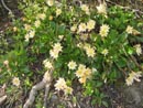
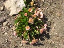
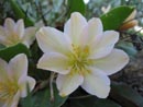
Driving the road I spotted some Tweedy's Lewisia and Gary stopped. It turned out to be a whole hill side of Lewisia. It was more in one place than I had seen in 25 years of hiking. I can count on one hand the number of times I had seen it. Usually it was just a few clumps of flowers. The trip was off to an unexpectedly good start. There are several deep wheel ruts higher on the road. An average passenger car could likely make it but four wheel drive and high clearance sure helps. This was Gary's first logging road with his new RAV 4. We had no problems.
Up at the parking area we immediately noticed the wind. It was a steady cold breeze. Kim mentioned that she would be here early in the morning after camping in the area and I was surprised to not see her truck. I walked farther up the road to the north and found one guy who camped overnight. He mentioned the rain and wind the day before and much of the night. We arrived at about 9:15 am. By 9:30 we were ready to hit the trail. I figured Kim must have gone elsewhere. In fact she did arrive after us, hiked the trail, and left before we returned. A case of missed connections.
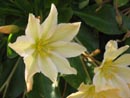
At the last minute I unzipped my pants legs and took off my long sleeve polypro shirt. I started in shorts and a short sleeve shirt. The overnight camper mentioned hiking a mile or so up the trail the day before and being disappointed that so few flowers were in bloom. He just didn't go far enough. We found lupine, Lyall's Mariposa, and a few dozen other flowers near the start. The real show was higher up on the ridge.
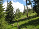
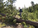
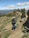
The trail is open to motorcycles though not until June 15th. We did not see any on the day. This trip also proved to be a rarity. Neither Gary nor I had ever hiked it before. As with most motorcycle trails, it never was steep. It began with a few long switchbacks then followed the ridge. Sometimes it was on the west side and sometimes on the east. The east side was out of the wind and much of the west side was in forest. Though chilly at times, I was doing fine in short sleeves and shorts. So much for the upper 40 degree forecast at that elevation.
The trail head is at 4200', just 100' higher than Blewett Pass. It slowly gains elevation as the ridge proceeds south. We did not notice the downhill sections on the way in. We definitely did notice them as they became uphill sections on the way back. All those 50 and 100 foot gains added up. Gary and I did a 35 mile mountain bike ride on Friday and we both had tired legs two days later. Gary coined this syndrome as "vigor mortis" and it seemed appropriate. For such an easy trail I think we hiked slower than at any time I can recall. All the blooming flowers did not help our pace.
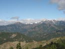
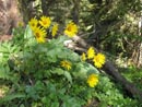
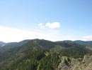
Early June is a great time to photograph flowers on Tronsen Ridge. We saw paintbrush, wallflower, ball head waterleaf, and many more as we continued on. Views began to open up as well. To the west we were able to pick out Miller Peak, Earl, Navaho, and all Three Brothers. Mt. Stuart was in the clouds but much of the Stuart Range came out over the course of the day. At about 2 1/2 miles we reached the trail down to Red Hill. I thought that might be our objective but with the sunshine and flowers the ridge was the place to be.
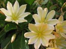
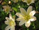
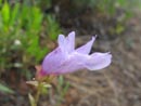
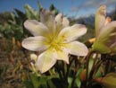
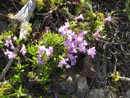
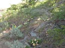
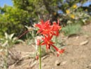
Ahead we came out of the forest for a traverse below the ridge on completely open slopes. Now we saw new flowers. There was more Tweedy's Lewisia. In fact it seemed to go on and on. We saw scarlet gilia. In a few places there was bitterroot. The sunny west side also had sagebrush. The balsamroot was about done lower down but it was just peaking as we ascended the ridge. The wind got to be too much for me here and we stopped to put on wind shirts. That really did the trick.
Where we crossed over to the east side of the ridge I was surprised to see much more lewisia. It grew well in the open barren rocky slopes on the west side of the ridge and in shadier forest on the east side. All of it seemed to be in bloom at once. One flat spot on the ridge top had many dozens of tiny bitterroot just blooming. There were also gilia and some bright yellow flowers.
We stopped for a break on a traverse below a vertical wall. I took another half dozen Tweedy's photos here. As we were packing up I took a look straight up the rock. It was colored yellow and red. Unlike anything I have seen before. I have seen small patches of fungus coloring on rock but not a whole wall. Very nice. In places we were in a dark forest of tall fir and pine trees with only grass for a ground cover. One of these went as far down the slope as we could see.
As we crested the ridge at a large flat park we headed off trail for lunch. It was now almost noon. We were about 4 1/2 miles in and it took us 2 1/2 hours Not a blazing pace. Our lunch viewpoint had a view down to the highway near Blewett Pass and views west to near the Cascade Crest. It turned out that the overnight camper, who started at about the same time as us, had also stopped at this same place. We spent a half hour eating and enjoying the view. The wind was stiff enough now to warrant a jacket.
From our 5280' lunch spot we dropped 140' then began a slow steady ascent. The trail was mostly on the east side of the ridge now. We began to see more different flowers here. There was lots of old man's whiskers and phlox. We saw some fresh glacier lilies then a few snow patches. There were more than half a dozen large trees down across the trail from the lunch spot on. I hope these are cut out ASAP as I would hate to see motorcycle trails going way off the trail to get around them. At long last we came out at a sign in a meadow. All it said was "Beware of Hypothermia". The trail became the remnant of an old road now going downhill in a grassy meadow.
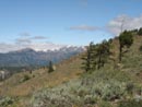
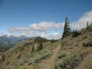
We stopped so Gary could set a waypoint on his new GPS then went back to the sign. We calculated that we were about 6 miles up the trail and only a mile from the south trailhead at Haney Meadow. We had no desire to go downhill and were glad to turn around. Before heading back though we followed a road a short way to the high point of the trip. This open point at about 5900' had terrific views to the west. Mt. Stuart was still in the clouds but most everything else was not. The wind was howling here and it was very cold. Clouds were thicker here but there was still plenty of sun as we headed back.
We took a way trail straight down the slope to reconnect with the main trail. Vigor mortis was really setting in now. We were running out of gas but at least it was mostly downhill. All those little downhills on the way in seemed to be much bigger uphills on the way back. It was only 1700' of gain from the start to the high point. We added up all the uphills coming out via altimeter and it added up to a total gain of 2900' on the day. A bit more than we were expecting.
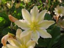
Back at our lunch spot we chose to take a look at the east side of this meadow and were amply rewarded. There was scarlet gilia, bitterroot, white phlox, pink phlox, larkspur, and more. We had nice views down to Devils Gulch, across to Mission Ridge, up to the ski area, and out into Central Washington. I spotted a little color down the slope and went down to check it out. I found another huge patch of Tweedy's Lewisia. Some of the best of the day. We spent a lot of time taking photos here.
The last 4 1/2 miles out was a very pleasant and mostly downhill ridge walk. We made it back to the car at about 5:00 pm. It was a long and very enjoyable day. The ridge has a great combination of mountain and desert flowers. In that way it was much like my recent visit to the Kettle Crest area. Right up to the last minute we were resigned to a rainy hike on the west slopes of the Cascades and instead we had a sunny albeit windy day on the far eastern slopes. The flowers were outstanding. I saw a lifetime of Tweedy's Lewisia in one day. I'm sure I will be back to Tronsen Ridge in the not too distant future
Click on thumbnails to get larger pictures.
Photo Page 2
Trips - 2007
Home
By Sunday morning the forecast was a little better though still poor. A check of weather stations showed zero wind in Cashmere. We bit the bullet and decided to take a chance. We met at Eastgate at 7:00 am and headed east. It was dark and dreary until it began to clear near Cle Elum. Driving north over Blewett (Swauk) Pass it became even clearer. We were feeling better about our decision. Just short of five miles north of Blewett Pass we turned right on Five Mile Road. It is only 3.1 miles to the trailhead. The road has some big berms down low. Higher there is a heck of a drop off the side of the road. It is very narrow through here. The old pull outs now have small trees and brush covering them. I would not want to meet another car there.
Driving the road I spotted some Tweedy's Lewisia and Gary stopped. It turned out to be a whole hill side of Lewisia. It was more in one place than I had seen in 25 years of hiking. I can count on one hand the number of times I had seen it. Usually it was just a few clumps of flowers. The trip was off to an unexpectedly good start. There are several deep wheel ruts higher on the road. An average passenger car could likely make it but four wheel drive and high clearance sure helps. This was Gary's first logging road with his new RAV 4. We had no problems.
Up at the parking area we immediately noticed the wind. It was a steady cold breeze. Kim mentioned that she would be here early in the morning after camping in the area and I was surprised to not see her truck. I walked farther up the road to the north and found one guy who camped overnight. He mentioned the rain and wind the day before and much of the night. We arrived at about 9:15 am. By 9:30 we were ready to hit the trail. I figured Kim must have gone elsewhere. In fact she did arrive after us, hiked the trail, and left before we returned. A case of missed connections.
At the last minute I unzipped my pants legs and took off my long sleeve polypro shirt. I started in shorts and a short sleeve shirt. The overnight camper mentioned hiking a mile or so up the trail the day before and being disappointed that so few flowers were in bloom. He just didn't go far enough. We found lupine, Lyall's Mariposa, and a few dozen other flowers near the start. The real show was higher up on the ridge.
The trail is open to motorcycles though not until June 15th. We did not see any on the day. This trip also proved to be a rarity. Neither Gary nor I had ever hiked it before. As with most motorcycle trails, it never was steep. It began with a few long switchbacks then followed the ridge. Sometimes it was on the west side and sometimes on the east. The east side was out of the wind and much of the west side was in forest. Though chilly at times, I was doing fine in short sleeves and shorts. So much for the upper 40 degree forecast at that elevation.
The trail head is at 4200', just 100' higher than Blewett Pass. It slowly gains elevation as the ridge proceeds south. We did not notice the downhill sections on the way in. We definitely did notice them as they became uphill sections on the way back. All those 50 and 100 foot gains added up. Gary and I did a 35 mile mountain bike ride on Friday and we both had tired legs two days later. Gary coined this syndrome as "vigor mortis" and it seemed appropriate. For such an easy trail I think we hiked slower than at any time I can recall. All the blooming flowers did not help our pace.
Early June is a great time to photograph flowers on Tronsen Ridge. We saw paintbrush, wallflower, ball head waterleaf, and many more as we continued on. Views began to open up as well. To the west we were able to pick out Miller Peak, Earl, Navaho, and all Three Brothers. Mt. Stuart was in the clouds but much of the Stuart Range came out over the course of the day. At about 2 1/2 miles we reached the trail down to Red Hill. I thought that might be our objective but with the sunshine and flowers the ridge was the place to be.
Ahead we came out of the forest for a traverse below the ridge on completely open slopes. Now we saw new flowers. There was more Tweedy's Lewisia. In fact it seemed to go on and on. We saw scarlet gilia. In a few places there was bitterroot. The sunny west side also had sagebrush. The balsamroot was about done lower down but it was just peaking as we ascended the ridge. The wind got to be too much for me here and we stopped to put on wind shirts. That really did the trick.
Where we crossed over to the east side of the ridge I was surprised to see much more lewisia. It grew well in the open barren rocky slopes on the west side of the ridge and in shadier forest on the east side. All of it seemed to be in bloom at once. One flat spot on the ridge top had many dozens of tiny bitterroot just blooming. There were also gilia and some bright yellow flowers.
We stopped for a break on a traverse below a vertical wall. I took another half dozen Tweedy's photos here. As we were packing up I took a look straight up the rock. It was colored yellow and red. Unlike anything I have seen before. I have seen small patches of fungus coloring on rock but not a whole wall. Very nice. In places we were in a dark forest of tall fir and pine trees with only grass for a ground cover. One of these went as far down the slope as we could see.
As we crested the ridge at a large flat park we headed off trail for lunch. It was now almost noon. We were about 4 1/2 miles in and it took us 2 1/2 hours Not a blazing pace. Our lunch viewpoint had a view down to the highway near Blewett Pass and views west to near the Cascade Crest. It turned out that the overnight camper, who started at about the same time as us, had also stopped at this same place. We spent a half hour eating and enjoying the view. The wind was stiff enough now to warrant a jacket.
From our 5280' lunch spot we dropped 140' then began a slow steady ascent. The trail was mostly on the east side of the ridge now. We began to see more different flowers here. There was lots of old man's whiskers and phlox. We saw some fresh glacier lilies then a few snow patches. There were more than half a dozen large trees down across the trail from the lunch spot on. I hope these are cut out ASAP as I would hate to see motorcycle trails going way off the trail to get around them. At long last we came out at a sign in a meadow. All it said was "Beware of Hypothermia". The trail became the remnant of an old road now going downhill in a grassy meadow.
We stopped so Gary could set a waypoint on his new GPS then went back to the sign. We calculated that we were about 6 miles up the trail and only a mile from the south trailhead at Haney Meadow. We had no desire to go downhill and were glad to turn around. Before heading back though we followed a road a short way to the high point of the trip. This open point at about 5900' had terrific views to the west. Mt. Stuart was still in the clouds but most everything else was not. The wind was howling here and it was very cold. Clouds were thicker here but there was still plenty of sun as we headed back.
We took a way trail straight down the slope to reconnect with the main trail. Vigor mortis was really setting in now. We were running out of gas but at least it was mostly downhill. All those little downhills on the way in seemed to be much bigger uphills on the way back. It was only 1700' of gain from the start to the high point. We added up all the uphills coming out via altimeter and it added up to a total gain of 2900' on the day. A bit more than we were expecting.
Back at our lunch spot we chose to take a look at the east side of this meadow and were amply rewarded. There was scarlet gilia, bitterroot, white phlox, pink phlox, larkspur, and more. We had nice views down to Devils Gulch, across to Mission Ridge, up to the ski area, and out into Central Washington. I spotted a little color down the slope and went down to check it out. I found another huge patch of Tweedy's Lewisia. Some of the best of the day. We spent a lot of time taking photos here.
The last 4 1/2 miles out was a very pleasant and mostly downhill ridge walk. We made it back to the car at about 5:00 pm. It was a long and very enjoyable day. The ridge has a great combination of mountain and desert flowers. In that way it was much like my recent visit to the Kettle Crest area. Right up to the last minute we were resigned to a rainy hike on the west slopes of the Cascades and instead we had a sunny albeit windy day on the far eastern slopes. The flowers were outstanding. I saw a lifetime of Tweedy's Lewisia in one day. I'm sure I will be back to Tronsen Ridge in the not too distant future
First Patch |
Tweedy's Lewisia |
Colorful |
Twins |
Last Along Road |
Start Of Trail |
Teaaway Peaks |
Penstemon |
Down Log |
Balsamroot |
Sagebrush |
More Tweedy's |
Pink Lewisia |
Tronsen Ridge |
Gary |
penstemon |
At The Peak |
Everywhere! |
Scarlet Gilia |
Looking Back |
Photo Page 2
Trips - 2007
Home