9-06-08
Everyone else was off hiking or backpacking this weekend
so I had a couple rare solo trips. Saturday I headed up to the Rachel
Lake trailhead. It was obvious that Labor Day had come and gone as there
were only a few cars in the lot at 8:40 am. It was completely overcast
though the sun was supposed to break through be late morning. I planned
to get most of the elevation gain in before the heat of the day. That proved
to be no problem. After a mile warm-up I was down to shorts and short sleeves.
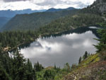
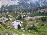
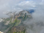
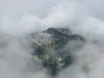
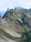
The flats went fast then the climb to Rachel Lake was just as rooty and rocky as I remembered. Five years had gone by since my last visit. The top of Hibox was in the clouds and I began to wonder what Alta would be like. I could see the summit as I drove by Hyak but now the clouds seemed even thicker. I reached the lake in 1:40. There was one group by the shore and another just leaving for the ridge top. After a quick food and water break I headed on up. Soon I could see down to Rachel Lake but not out as the clouds were not far above me.
At the ridge top junction I caught up with the two guys I had briefly seen at the lake. Turns out they too were heading for Alta. I went first and shortly turned off for a break at a viewpoint. They went on by. I had not noticed any bugs at the lake but now a dozen of them landed on me. The break was a short one. I quickly caught up with the other guys and went back ahead.
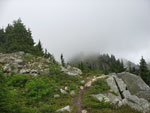
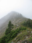
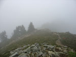
The junction for Alta or Lila Lakes is unsigned but is much easier to see than I remembered. I turned left and almost immediately started the steep climb up the ridge. A few minutes later I saw the two guys at the junction. That was the last I saw of them. There are some ripe berries on the ridge but less than normal and much smaller. I left them for the animals. I did hear the whistle of marmots and saw one guy pretty close up. After reaching the first hump I was in the clouds. Visibility was now about 100'. I did not have to worry about overheating in the warm sunshine that was predicted.
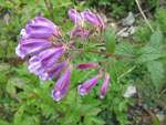
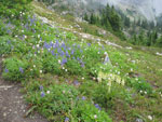
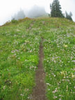
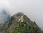
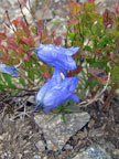
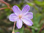
There are still flowers blooming along the ridge. Some are done but there are many more left than I expected. With the low visibility and flowers the ridge walk was much different than I have ever had there. I was kind of eerie as I could just make out the silhouette of the next false summit and then the next. High on the ridge I met a solo hiker with a dog. They had spent 45 minutes on the summit waiting for the clouds to part. Finally they gave up and headed down.
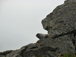
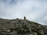
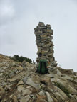
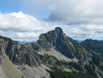
After even a few more false summits than I remembered I reached the last saddle and climbed up to the top. From below the summit I saw a monolith jutting up from the peak. As I got closer it became clear that it is a huge cairn. It is about 7 feet tall and growing. It was not there back in 2003. The summit register also is no longer there. I checked to see if it was tucked into a pocket in the cairn but to no avail.
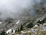
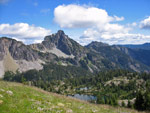
I reached the top just before noon. It took me 3:11 to hike up 6 miles with about 3350' of gain. On a clear day one could look over to the Kendall Katwalk and see most of the Pacific Crest Trail for the next dozen miles. Not this day. I could briefly see the tarns below me as they went in and out of the clouds. I spent 45 minutes on top hoping for some views. I was not entirely disappointed. Three Queens and Hibox came into view periodically. I saw Red Mountain and the Katwalk plus Alaska Lake in short breaks in the blowing clouds.
I head voices but never did see anybody else. The other guys may have made it to the last false summit but did not go farther. On about my second step down from the summit I had a sharp pain in my right foot. Hmm... not a great place to be incapacitated. More than 3000' of steep crappy trail to descend. I'm going to blame it on the new boots. I relaced them and it was a little better. Still not a lot of fun on the descent. The next day in low top boots there was no pain at all. Hopefully this will not recur.
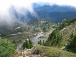
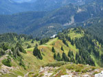
On the way down the ridge there were some shafts of sunlight through the gray. This provided some interesting photo opportunities. Between foot and photos I was not blazing along. Once back at the ridge top junction I decided to go ahead with my original plan and head over to Rampart Lakes. It only took 13 minutes to reach the first lake. Much quicker than I expected. There were people on this trail and at the lakes. The first people I had seen in a few hours. After a short visit it was time to head back. I was very surprised to see some snow patches on the ridge top in September.
Dropping to Rachel Lake I could now see a number of tents at the lake. I saw larger groups at the lake. The trail down was busy with folks still coming up. Not as busy as mid summer but it was clear that a lot of folks have not put away the boots just yet this year. I came down to find the lot now much fuller. With the steepness of the rocky trail and my foot problem, it took just about the same amount of time to go down as it had up. It was even getting sunny by late afternoon.
This is a favorite destination of mine. I do not much like the "route" up to Rachel Lake but what lies above is well worth the effort. I have done it in bright sun and rain but this misty day of clouds was different and in some ways as beautiful as a clear day can be. It was nice to have the whole ridge and summit to myself too. I'm sure I'll be back in the next five years.
Click on thumbnails to get larger pictures.
Trips - 2008
Home
The flats went fast then the climb to Rachel Lake was just as rooty and rocky as I remembered. Five years had gone by since my last visit. The top of Hibox was in the clouds and I began to wonder what Alta would be like. I could see the summit as I drove by Hyak but now the clouds seemed even thicker. I reached the lake in 1:40. There was one group by the shore and another just leaving for the ridge top. After a quick food and water break I headed on up. Soon I could see down to Rachel Lake but not out as the clouds were not far above me.
At the ridge top junction I caught up with the two guys I had briefly seen at the lake. Turns out they too were heading for Alta. I went first and shortly turned off for a break at a viewpoint. They went on by. I had not noticed any bugs at the lake but now a dozen of them landed on me. The break was a short one. I quickly caught up with the other guys and went back ahead.
The junction for Alta or Lila Lakes is unsigned but is much easier to see than I remembered. I turned left and almost immediately started the steep climb up the ridge. A few minutes later I saw the two guys at the junction. That was the last I saw of them. There are some ripe berries on the ridge but less than normal and much smaller. I left them for the animals. I did hear the whistle of marmots and saw one guy pretty close up. After reaching the first hump I was in the clouds. Visibility was now about 100'. I did not have to worry about overheating in the warm sunshine that was predicted.
There are still flowers blooming along the ridge. Some are done but there are many more left than I expected. With the low visibility and flowers the ridge walk was much different than I have ever had there. I was kind of eerie as I could just make out the silhouette of the next false summit and then the next. High on the ridge I met a solo hiker with a dog. They had spent 45 minutes on the summit waiting for the clouds to part. Finally they gave up and headed down.
After even a few more false summits than I remembered I reached the last saddle and climbed up to the top. From below the summit I saw a monolith jutting up from the peak. As I got closer it became clear that it is a huge cairn. It is about 7 feet tall and growing. It was not there back in 2003. The summit register also is no longer there. I checked to see if it was tucked into a pocket in the cairn but to no avail.
I reached the top just before noon. It took me 3:11 to hike up 6 miles with about 3350' of gain. On a clear day one could look over to the Kendall Katwalk and see most of the Pacific Crest Trail for the next dozen miles. Not this day. I could briefly see the tarns below me as they went in and out of the clouds. I spent 45 minutes on top hoping for some views. I was not entirely disappointed. Three Queens and Hibox came into view periodically. I saw Red Mountain and the Katwalk plus Alaska Lake in short breaks in the blowing clouds.
I head voices but never did see anybody else. The other guys may have made it to the last false summit but did not go farther. On about my second step down from the summit I had a sharp pain in my right foot. Hmm... not a great place to be incapacitated. More than 3000' of steep crappy trail to descend. I'm going to blame it on the new boots. I relaced them and it was a little better. Still not a lot of fun on the descent. The next day in low top boots there was no pain at all. Hopefully this will not recur.
On the way down the ridge there were some shafts of sunlight through the gray. This provided some interesting photo opportunities. Between foot and photos I was not blazing along. Once back at the ridge top junction I decided to go ahead with my original plan and head over to Rampart Lakes. It only took 13 minutes to reach the first lake. Much quicker than I expected. There were people on this trail and at the lakes. The first people I had seen in a few hours. After a short visit it was time to head back. I was very surprised to see some snow patches on the ridge top in September.
Dropping to Rachel Lake I could now see a number of tents at the lake. I saw larger groups at the lake. The trail down was busy with folks still coming up. Not as busy as mid summer but it was clear that a lot of folks have not put away the boots just yet this year. I came down to find the lot now much fuller. With the steepness of the rocky trail and my foot problem, it took just about the same amount of time to go down as it had up. It was even getting sunny by late afternoon.
This is a favorite destination of mine. I do not much like the "route" up to Rachel Lake but what lies above is well worth the effort. I have done it in bright sun and rain but this misty day of clouds was different and in some ways as beautiful as a clear day can be. It was nice to have the whole ridge and summit to myself too. I'm sure I'll be back in the next five years.
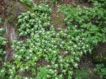
Bunchberries |
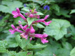
Pink Flower |
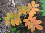
Fall Colors |
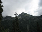
Cloudy Hibox |
Rachel Lake |
Penstemon |
Marmot |
Into The Clouds |
Lila Lakes |
Lupine |
Trail To The Clouds |
Ridge Top Trail |
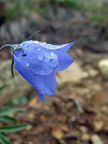
Raindrops On Bloom |
What's Ahead? |
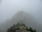
Another Bump Ahead |
Summit In Sight |
Seven Foot Cairn |
Tarns In The Mist |
Alta Ridge |
PCT? |
Alaska Lake |
Harebells? |
Clearing Over Lila Lakes |
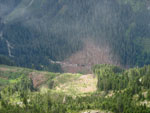
Big Avalanche |

Three Queens |
Trail To Alta Pass? |
Green Ridge |
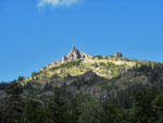
Hibox Mountain |
Hibox And Lilas |
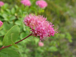
Spirea |

Alta From Ramparts |
Columbia Lewisia? |
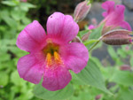
Monkey Flower |
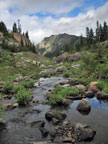
Creek And Alta |
Blue Sky & Hibox |
Trips - 2008
Home