6-14-08
Gary and I had been out on any trips since the start
of the year. He was free and was interested in a scramble. Suzanne and Barry
were also free for a trip. I kicked around a few ideas and Gary had some
and we ended up with Miller Peak via the Iron Creek Trail. Three of us met
in North Seattle and we picked up Gary at Eastgate. By 7:00 am we were heading
east. Traffic was pretty light and we cruised over I-90 then took 970 and
97 north. 2.3 miles north of Mineral Springs we turned left on the Iron Creek
Road. The road is in good shape. There is a creek crossing near the end
but the water was low and most cars can get through it.
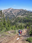
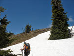
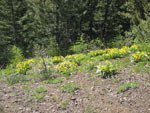
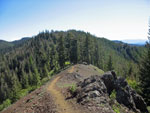
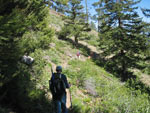
By 8:40 we were in the lot. Two more cars came in as we were getting ready. By 8:50 we were on the trail. It was a little chilly at first but warmed up quickly. We had several creek crossings in the first mile then there was no more water on the route. This is a motorcycle trail and it graded very gently. There are often many flowers on this south facing slope in the spring. This year it was good but not great.
We did see balsamroot, paintbrush, and a number of others but no gilia or bitterroot. We made good time up the gently trail reaching the intersection at Iron Bear Pass in about 45 minutes. The slope below the pass had lots of flowering balsamroot. Now came a few long switchbacks up the slope of Iron Bear Peak. Barry and Suzanne were flying out ahead and Gary and I were keeping up a reasonably good pace behind. I knew I was pushing my knee recovery with two sizable trips planned this weekend so I did take it a little easier.
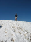
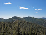
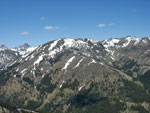
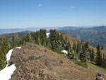
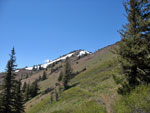
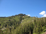
Near the top of Iron Bear we found a little snow. Suzanne dog Gusto found it a great place to lay down and cool off as always. We took a break on top and enjoyed the views. We could just make out Red Top Lookout. We had a long snowshoe slog up there during this past winter. Mt. Rainier was crystal clear. To the north we saw Stuart and Miller Peak. It still seemed to be a long way off. It's about 3 1/2 miles to the top of Iron Bear. We had 3 more miles to go for Miller.
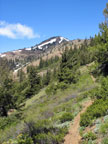
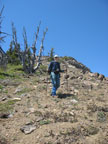
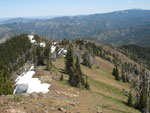
From the top we had a north facing forested section of trail and as expected it was largely under snow. Not as much snow as I expected. We were soon past the snow and down to the intersection with the County Line Trail. The trail traversed around Point 5510 and we contemplated climbing the few hundred feet to the top on our way back. Once around to the north side the trail makes a precipitous drop straight down the slope to the pass below. This steep loose rocky rut had my sore knee screaming. I was much slower than the others getting down.
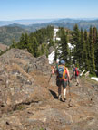
At the bottom we met the Shaser Creek Road. No motorcycles here this day. Now back out of the forest we had more wildflowers. Good but not great once again. The route began to climb up towards Miller Peak. When we reached the spot where the ridge climbs up away from the trail, Barry chose to take the high route. This is the way I usually climb Miller. We were eying the gentler snowy ridge coming down farther south on Miller.
That ridge is the way Suzanne had been up Miller last year. As we neared the ridge we could see a pretty steep snow slope to cross to attain the ridge. Not far but pretty steep. We chose instead to climb straight up to the ridge Barry was following. The slope is grassy with some rock and scree. It was no bad at all to climb. Near the top we could see Barry on the final climb to the top of Miller. He was about 5 minutes ahead of us.
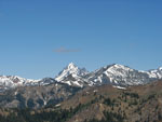
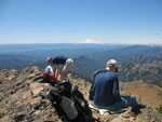
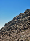
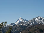
We reached the ridge top right where it begins to climb steeply and up we went. There was snow on the slope but none right where we were headed. It was dirt and scree all the way up. I was slowing down now but not too far behind the others. The top of Miller was well worth the effort. It was warm now with a light cool breeze blowing through. We could see Rainier was still not yet hazy and Mt. Adams was even in the clear. Some clouds near the Cascade crest south of Snoqualmie Pass but none anywhere us.
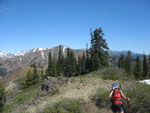
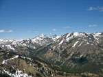
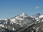
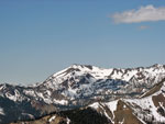
We spent nearly an hour on top. There is still a lot of snow on the east sides of Earl, Navaho, and Little Navaho. Ingalls, South Ingalls, and Fortune looked to have even more. Stuart looks like a sharp pyramid from this angle, much different than from most Teanaway Peaks. We chose to descend the same way we came up. At the bottom of the steeper section we stayed on the ridge top. This was the same route Barry took on the way up.
The ridge is an enjoyable walk with some trees and a few easy scramble sections. There was still snow along much of the ridge top though it will be gone soon. There was one scramble spot where I was concerned if Gusto could get down but he had no trouble at all. One more knee bashing short down climb and we were back on the County Line Trail. As we neared the saddle we met a lone mountain biker. He had come up from the Miller/Bear Creeks parking lot. He had some big logs to cross and snow to cross with his bike but was heading on to Miller.
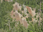
We climbed back up the steep rut and traversed around Point 5510. Near the high point on the trail we headed straight up. It wa mostly grassy with some trees as well. The forest around Point 5510 is partly larch trees. Near the top the slope flattens. It is a ways father to the real high point but not much higher. Here we stumbled upon a couple who thought they had found some off trail privacy. We chose to respect there privacy and did not go on the last bit to the top.
We dropped again to the trail, hit the County Line intersection, and headed up the short climb to Iron Bear Peak. We bypassed the very top but did see a couple hikers when we looked back from lower down. It was getting pretty warm and shorts and short sleeves were plenty warm. It finally felt like summer. We passed one more couple on the way down. It as after just after 4:00 pm when I reached the trailhead.
This was a very nice day in the mountains. We finally had a mountain hike that was almost entirely on dirt. It has been a long time since we were not on snow. It wa warm but not hot. We met a few hikers but not very many. The flowers were good if not as good as I had hoped for. It was nice to finally get out with Gary once again. Soon there will be larger numbers of hikers heading up Miller by way of the much shorter Miller Creek route but his day we had most of the area to ourselves.
Suzanne's report is here: Nwhikers Report & Photos
Click on thumbnails to get larger pictures.
Trips - 2008
Home
By 8:40 we were in the lot. Two more cars came in as we were getting ready. By 8:50 we were on the trail. It was a little chilly at first but warmed up quickly. We had several creek crossings in the first mile then there was no more water on the route. This is a motorcycle trail and it graded very gently. There are often many flowers on this south facing slope in the spring. This year it was good but not great.
We did see balsamroot, paintbrush, and a number of others but no gilia or bitterroot. We made good time up the gently trail reaching the intersection at Iron Bear Pass in about 45 minutes. The slope below the pass had lots of flowering balsamroot. Now came a few long switchbacks up the slope of Iron Bear Peak. Barry and Suzanne were flying out ahead and Gary and I were keeping up a reasonably good pace behind. I knew I was pushing my knee recovery with two sizable trips planned this weekend so I did take it a little easier.
Near the top of Iron Bear we found a little snow. Suzanne dog Gusto found it a great place to lay down and cool off as always. We took a break on top and enjoyed the views. We could just make out Red Top Lookout. We had a long snowshoe slog up there during this past winter. Mt. Rainier was crystal clear. To the north we saw Stuart and Miller Peak. It still seemed to be a long way off. It's about 3 1/2 miles to the top of Iron Bear. We had 3 more miles to go for Miller.
From the top we had a north facing forested section of trail and as expected it was largely under snow. Not as much snow as I expected. We were soon past the snow and down to the intersection with the County Line Trail. The trail traversed around Point 5510 and we contemplated climbing the few hundred feet to the top on our way back. Once around to the north side the trail makes a precipitous drop straight down the slope to the pass below. This steep loose rocky rut had my sore knee screaming. I was much slower than the others getting down.
At the bottom we met the Shaser Creek Road. No motorcycles here this day. Now back out of the forest we had more wildflowers. Good but not great once again. The route began to climb up towards Miller Peak. When we reached the spot where the ridge climbs up away from the trail, Barry chose to take the high route. This is the way I usually climb Miller. We were eying the gentler snowy ridge coming down farther south on Miller.
That ridge is the way Suzanne had been up Miller last year. As we neared the ridge we could see a pretty steep snow slope to cross to attain the ridge. Not far but pretty steep. We chose instead to climb straight up to the ridge Barry was following. The slope is grassy with some rock and scree. It was no bad at all to climb. Near the top we could see Barry on the final climb to the top of Miller. He was about 5 minutes ahead of us.
We reached the ridge top right where it begins to climb steeply and up we went. There was snow on the slope but none right where we were headed. It was dirt and scree all the way up. I was slowing down now but not too far behind the others. The top of Miller was well worth the effort. It was warm now with a light cool breeze blowing through. We could see Rainier was still not yet hazy and Mt. Adams was even in the clear. Some clouds near the Cascade crest south of Snoqualmie Pass but none anywhere us.
We spent nearly an hour on top. There is still a lot of snow on the east sides of Earl, Navaho, and Little Navaho. Ingalls, South Ingalls, and Fortune looked to have even more. Stuart looks like a sharp pyramid from this angle, much different than from most Teanaway Peaks. We chose to descend the same way we came up. At the bottom of the steeper section we stayed on the ridge top. This was the same route Barry took on the way up.
The ridge is an enjoyable walk with some trees and a few easy scramble sections. There was still snow along much of the ridge top though it will be gone soon. There was one scramble spot where I was concerned if Gusto could get down but he had no trouble at all. One more knee bashing short down climb and we were back on the County Line Trail. As we neared the saddle we met a lone mountain biker. He had come up from the Miller/Bear Creeks parking lot. He had some big logs to cross and snow to cross with his bike but was heading on to Miller.
We climbed back up the steep rut and traversed around Point 5510. Near the high point on the trail we headed straight up. It wa mostly grassy with some trees as well. The forest around Point 5510 is partly larch trees. Near the top the slope flattens. It is a ways father to the real high point but not much higher. Here we stumbled upon a couple who thought they had found some off trail privacy. We chose to respect there privacy and did not go on the last bit to the top.
We dropped again to the trail, hit the County Line intersection, and headed up the short climb to Iron Bear Peak. We bypassed the very top but did see a couple hikers when we looked back from lower down. It was getting pretty warm and shorts and short sleeves were plenty warm. It finally felt like summer. We passed one more couple on the way down. It as after just after 4:00 pm when I reached the trailhead.
This was a very nice day in the mountains. We finally had a mountain hike that was almost entirely on dirt. It has been a long time since we were not on snow. It wa warm but not hot. We met a few hikers but not very many. The flowers were good if not as good as I had hoped for. It was nice to finally get out with Gary once again. Soon there will be larger numbers of hikers heading up Miller by way of the much shorter Miller Creek route but his day we had most of the area to ourselves.
Suzanne's report is here: Nwhikers Report & Photos
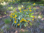
Balsamroot |
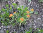
Indian Paintbrush |
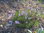
Penstemon |
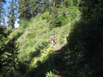
On The Trail |
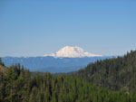
Mt. Rainier |
Barry On Iron Bear |
Miller From Iron Bear |
Stuart From IB |
Dropping To Saddle |
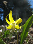
Glacier Lily |
Iron Bear Peak |
Miller Is Ahead |
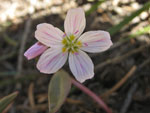
Spring Beauty |

Last Climb |
Near Summit |
View Northwest |
Stuart & Navaho |
Three Brothers |
Group On Summit |
Earl Peak |
Gary Descending |
Ridge Route |
Barry & Suzanne |
Gary Scrambling |
Along The Ridge |
Back On Trail |
One More Stuart |
More Balsamroot |
Near Iron Bear Pass |
Towards IB Peak |
Lower Trail |
Trail Across Valley |
Trips - 2008
Home