3-02-08
It looked like a good weekend to head east and escape
a cloudy Cascade crest. Suzanne, Kelly and I headed to Blewett Pass to meet
Bob, Kolleen, and Joe. We figured on 9:00 AM but we were both there a little
after 8:30. It was a chilly 23 degrees when we started out. Joe had done
half our proposed route the year before. The rest of us had not done any
of it. I did drive to Haney Meadow last summer for a hike and that would
be near our mid point. There were just a few snowmobile trailers in the lot.
Since this was a last minute idea I had only the evening before to try and
figure out the route. Joe did have a route route programmed into his GPS.
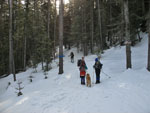
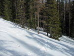
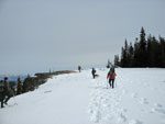
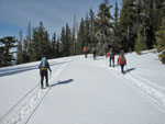
We started up the road and soon reached the Discovery Trail. This is a 2 mile summer loop trail with markers naming trees along the way. On the positive side, there were trail signs at most intersections. These are ski trails that have been around for many years. We found older tracks, ski and snowshoe, in the hard snow. Some tracks went all the way around our route.
We more or less followed a ridge above Tronsen Meadow heading towards Diamond Head. It was not steep though it gained elevation consistently though with a few ups and downs. The pace was pretty fast as we booted it along the hard snow route. Some folks did the whole route without snowshoes. Bob and I did put them on coming down when postholing became a problem for us heavyweights.
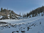
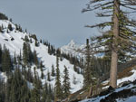
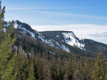
We reached an open slope right on the side of Diamond Head. I can see where this could be a problem with some avalanche danger. With the hard pack and the lack of recent snow at all the danger was very low. Bob, Kolleen, and Joe stopped for a food break and the rest of us continued on. Soon we crossed another open slope. The route took a leftward turn away from Diamond Head and left forest for an open bowl. A turn back to the right and we headed up the end of the valley towards a pass.
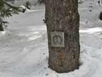
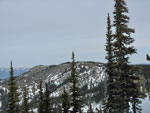
This was a neat place. There were some rocks sticking through but it was mostly snow. The contrast was striking. As we climbed higher we found a number of very big larch trees. No signs of needle activity yet. To our left was a bump we had heard referred to as Tronsen Head or Little Diamond Head. We came to another signed intersection. Left towards the Table Mountain Road and a route up Diamond Head. Straight ahead towards Haney Meadow. We debated trying to add Diamond Head to the loop but decided the loop alone would be enough.
At the saddle we saw yet another sign. Right to Haney Meadow. This may be correct but it is not the shortest way. A track went straight ahead as well. Off we went right towards Diamond Head and directly away from Haney Meadow. The route has blue diamonds all the way and we continued to follow them. Finally we switched back and then lost the diamonds. After map and GPS consultations we concluded we needed to turn around and head down.
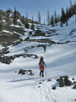
Within a few minutes we intersected a summer trail complete with a horseshoe sign indicating this is a horse trail. This route brought us to another signed intersection. Right to Haney Meadow. Left to Haney via the View Ridge Trail. We opted to go for the views rather than a flat forest walk to the meadow. A bit of gain and we could see out to Diamond Head, Tronsen Head, and the saddle we had been at earlier. It was now obvious that going straight at the saddle would have been much shorter and easier.
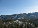
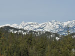
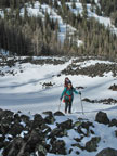
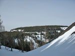
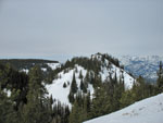
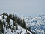
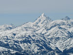
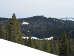
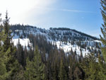
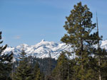
Views of the Stuart Range and various Teanaway peaks appeared. It had been all blue sky from the start but now high white clouds had blown in. The hoped for clear view of peaks to the west were dashed. Still it was a very nice view. The route continued to climb up the ridge. There were trees but it was partly open as well. As we moved higher the views improved in all directions. Even Mt. Rainier showed itself.
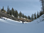
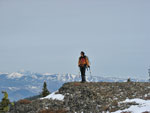
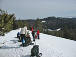
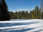
A bit of a breeze was blowing and it was cold once again. It was still only about 11:30 when we stopped for lunch. It took us about 3 hours to reach the high point. We started just below 4100' at Blewett Pass and the high point was near 5900'. With more clothing on it was perfectly comfortable on the ridge top. We could see Haney Meadow below and Mt. Lillian behind it. Tronsen ridge is already showing bare rock near the top on the west side. All in all, a very nice place to look at mountains.
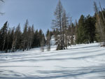
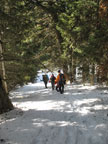
After lunch we headed right on down the ridge. The snow was still plenty firm as we plodded on down. We finally came out on a road which I recognized from last summer. It was just beyond Haney Meadow. We quickly reached a turn off for the Old Ellensburg Trail. At the Tronsen Meadow trail we left the road to the left. The route began a slow descent. sometimes on flats and sometimes side hilling. We still had a few snowshoe tracks but not as many.
At one point is seemed we had left the trail as we were now side hilling on steeper terrain. There did not seem to be any trail cut at all. When Bob and I began to posthole well past our knees we stopped to put on snowshoes. Soon after the snow firmed up but we just kept them on rather than stop again. As we finally began to drop faster we regained a trail bed. Less side hilling now and hence easier walking. We could see back up to Diamond Head and the whole ridge we had walked along earlier.
The fir forest began to include big ponderosa pines as well. Our route flattened and soon we come out into a clearing with a trail sign. This is the start of the summer Tronsen Ridge Trail. We could see the ridge we had ascended from Blewett Pass and tried to figure out the easier way to get over to it. Much map reading ensued and we chose to follow the road for awhile. It swung around the valley heading more or less in the correct direction.
The forest here is small trees densely packed and going cross country would not have been any fun. We took left road junctions where possible and reached an opening in the forest that must have been some of Tronsen Meadow. Another road took us uphill again. At an intersection we went left on a signed ski track uphill. When this route began to drop we checked the map and concluded it was headed to Highway 97 north of the pass.
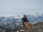
We went back off road and climbed again with the ridge now not too far away. Suzanne, Kolleen, were ahead and they saw a lone person. That was the only person of the day and I did not see him. Joe recognized our uphill route though none of the rest of us thought that was it. We followed it down then up to an intersection. That was indeed a place we had been on the way up.
The sign said .75 miles to the pass. In a few minutes we reached a road. The group crossed and Joe said he preferred to take road back down as his knees were hurting. I could not recall having crossed a road on the way up. Off we went be a big sign for the Discovery Trail that I did not recall seeing. Something was not looking right. Kelly and I called out to stop the group. We were certain we were on the other part of the Discovery Loop. The much longer part. We headed back a short bit and then straight down to reach the parking lot almost immediately. Our detour did not cost us too much time.
It's always fun to do a route for the first time. Half of the route none of had ever been on. Of course once we left the highest ridge the clouds all disappeared and we had bright blue sky once again. I came down the last 4 miles in short sleeves. Upper 30s and sunshine can be very warm when you are on the move. We had some fun route finding, some good views, a great ridge walk, and very good snow conditions. I would not have wanted to ski on the hard snow but it was great for boots. I can see making a return trip over here in the next few years. Especially on days when the Cascade crest is in the clouds.
Click on thumbnails to get larger pictures.
Trips - 2008
Home
We started up the road and soon reached the Discovery Trail. This is a 2 mile summer loop trail with markers naming trees along the way. On the positive side, there were trail signs at most intersections. These are ski trails that have been around for many years. We found older tracks, ski and snowshoe, in the hard snow. Some tracks went all the way around our route.
We more or less followed a ridge above Tronsen Meadow heading towards Diamond Head. It was not steep though it gained elevation consistently though with a few ups and downs. The pace was pretty fast as we booted it along the hard snow route. Some folks did the whole route without snowshoes. Bob and I did put them on coming down when postholing became a problem for us heavyweights.
We reached an open slope right on the side of Diamond Head. I can see where this could be a problem with some avalanche danger. With the hard pack and the lack of recent snow at all the danger was very low. Bob, Kolleen, and Joe stopped for a food break and the rest of us continued on. Soon we crossed another open slope. The route took a leftward turn away from Diamond Head and left forest for an open bowl. A turn back to the right and we headed up the end of the valley towards a pass.
This was a neat place. There were some rocks sticking through but it was mostly snow. The contrast was striking. As we climbed higher we found a number of very big larch trees. No signs of needle activity yet. To our left was a bump we had heard referred to as Tronsen Head or Little Diamond Head. We came to another signed intersection. Left towards the Table Mountain Road and a route up Diamond Head. Straight ahead towards Haney Meadow. We debated trying to add Diamond Head to the loop but decided the loop alone would be enough.
At the saddle we saw yet another sign. Right to Haney Meadow. This may be correct but it is not the shortest way. A track went straight ahead as well. Off we went right towards Diamond Head and directly away from Haney Meadow. The route has blue diamonds all the way and we continued to follow them. Finally we switched back and then lost the diamonds. After map and GPS consultations we concluded we needed to turn around and head down.
Within a few minutes we intersected a summer trail complete with a horseshoe sign indicating this is a horse trail. This route brought us to another signed intersection. Right to Haney Meadow. Left to Haney via the View Ridge Trail. We opted to go for the views rather than a flat forest walk to the meadow. A bit of gain and we could see out to Diamond Head, Tronsen Head, and the saddle we had been at earlier. It was now obvious that going straight at the saddle would have been much shorter and easier.
Views of the Stuart Range and various Teanaway peaks appeared. It had been all blue sky from the start but now high white clouds had blown in. The hoped for clear view of peaks to the west were dashed. Still it was a very nice view. The route continued to climb up the ridge. There were trees but it was partly open as well. As we moved higher the views improved in all directions. Even Mt. Rainier showed itself.
A bit of a breeze was blowing and it was cold once again. It was still only about 11:30 when we stopped for lunch. It took us about 3 hours to reach the high point. We started just below 4100' at Blewett Pass and the high point was near 5900'. With more clothing on it was perfectly comfortable on the ridge top. We could see Haney Meadow below and Mt. Lillian behind it. Tronsen ridge is already showing bare rock near the top on the west side. All in all, a very nice place to look at mountains.
After lunch we headed right on down the ridge. The snow was still plenty firm as we plodded on down. We finally came out on a road which I recognized from last summer. It was just beyond Haney Meadow. We quickly reached a turn off for the Old Ellensburg Trail. At the Tronsen Meadow trail we left the road to the left. The route began a slow descent. sometimes on flats and sometimes side hilling. We still had a few snowshoe tracks but not as many.
At one point is seemed we had left the trail as we were now side hilling on steeper terrain. There did not seem to be any trail cut at all. When Bob and I began to posthole well past our knees we stopped to put on snowshoes. Soon after the snow firmed up but we just kept them on rather than stop again. As we finally began to drop faster we regained a trail bed. Less side hilling now and hence easier walking. We could see back up to Diamond Head and the whole ridge we had walked along earlier.
The fir forest began to include big ponderosa pines as well. Our route flattened and soon we come out into a clearing with a trail sign. This is the start of the summer Tronsen Ridge Trail. We could see the ridge we had ascended from Blewett Pass and tried to figure out the easier way to get over to it. Much map reading ensued and we chose to follow the road for awhile. It swung around the valley heading more or less in the correct direction.
The forest here is small trees densely packed and going cross country would not have been any fun. We took left road junctions where possible and reached an opening in the forest that must have been some of Tronsen Meadow. Another road took us uphill again. At an intersection we went left on a signed ski track uphill. When this route began to drop we checked the map and concluded it was headed to Highway 97 north of the pass.
We went back off road and climbed again with the ridge now not too far away. Suzanne, Kolleen, were ahead and they saw a lone person. That was the only person of the day and I did not see him. Joe recognized our uphill route though none of the rest of us thought that was it. We followed it down then up to an intersection. That was indeed a place we had been on the way up.
The sign said .75 miles to the pass. In a few minutes we reached a road. The group crossed and Joe said he preferred to take road back down as his knees were hurting. I could not recall having crossed a road on the way up. Off we went be a big sign for the Discovery Trail that I did not recall seeing. Something was not looking right. Kelly and I called out to stop the group. We were certain we were on the other part of the Discovery Loop. The much longer part. We headed back a short bit and then straight down to reach the parking lot almost immediately. Our detour did not cost us too much time.
It's always fun to do a route for the first time. Half of the route none of had ever been on. Of course once we left the highest ridge the clouds all disappeared and we had bright blue sky once again. I came down the last 4 miles in short sleeves. Upper 30s and sunshine can be very warm when you are on the move. We had some fun route finding, some good views, a great ridge walk, and very good snow conditions. I would not have wanted to ski on the hard snow but it was great for boots. I can see making a return trip over here in the next few years. Especially on days when the Cascade crest is in the clouds.
First View Out |
Stuart & Teanaway Pks |
Signs |
Open Slope |
First Avalanche Swath |
Rocky Basin |
Suzanne & Kelly |
Kelly |
Framed Mt. Stuart |
Nearing Pass |
Diamond Head |
Back On Trail |
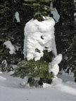
Flocked Tree |
Tronsen Head |
Stuart & Tronsen Head |
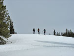
Waiting On The Ridge |
Near High Point |
Mt. Stuart Close Up |
Kolleen |
Suzanne & Gusto |
Tronsen Ridge |
Haney Meadow |
Lunch Time |
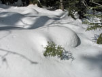
Snow Shapes |
Out In The Sunshine |
Heading Downhill |
Where We Were |
Diamond Head Again |
Stuart & Pine |
Tronsen Meadow |
Trips - 2008
Home