10-07-09
Gary took
Wednesday off work and asked if I could go for a hike. Daylight saving
time ends in 3 1/2 weeks and after work hikes will come to an end. I
worked until 12:30 and we headed north. Gary planned on hiking up Mt.
Pilchuck. Something away from the usual after work I-90 hikes. On the
drive up I mentioned we might have time to hike up the Walt Bailey
Trail and summit Bald Mountain. I have done the trip twice but not
since 2003. Gary had never been on the trail. I remembered it as being
8 or 9 miles with only 2100' of gain. It was not in any hiking guides
when I did it so my numbers were just estimates. Well, I might have
been a little off.
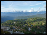
The road to the trailhead has been closed for three years due to washed out approaches to a bridge. It was just reopened about a month ago. We cruised down the Mountain Loop Highway and turned off right before Red Bridge. At about 1 1/2 miles we took the right fork. The road has been graded recently and is in great shape. Almost no potholes at all. One car was leaving as we arrived so we were able to park at the trailhead. There is not much room there though farther down the road are more spaces. A total of three cars were parked near the trailhead. One of them had a license plate border with "VIGGO" in big letters. I have had numerous emails via my website with someone with that name. Hmm...
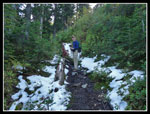
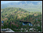
At 2:15 we were on the trail. Recent volunteer work has removed most of the logs that fell on the trail in the last three years. The others can be climbed around of over without much trouble. With only 4 1/4 hours before sunset we set a pretty fast pace. Unfortunately the trail is muddier and rootier than I remembered. Much slower than a steeper smooth trail. The trail went up then down to some meadows. Far fewer berries than I found on a November visit. Surprising since this has been a great berry year and the trail has only been open a few weeks.
As we hiked along one meadow another hiker was coming out. Gary asked if he was Viggo. In fact he was. He looked at Gary trying to recall if they had met. He looked harder and couldn't figure out who he was. Then he turned to me and said "Jim!" A priceless moment. Years of emails and we met at last. He recognized me from photos on my site. We had a nice short conversation then we were back on our way.
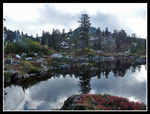
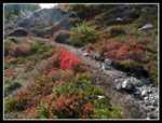
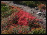
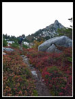
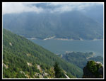
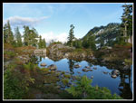
We dropped to the lowest meadow then began the climb to Cutthroat Lakes. Snow had been here a week earlier. It was almost all gone now but the trail was very muddy. Lots of near falls on the slick mud and rocks. At long last we crested the ridge and reached the first tarn. Some very nice color here. The forest had blocked the sun down lower but the huckleberry bushes were backlit a fiery red. Some more dropping then a short climb brought us to the largest lake. It was almost 4:00 pm now, much later than I had planned on. Still a mile and 650' to climb to get up Bald Mountain.
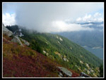
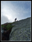
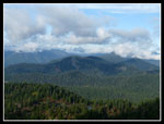
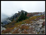
Gary picked up the pace as we began the climb. Higher up there was snow on the trail but not more than a few inches. As we climbed above the notch in Bald's east ridge I wondered if we were still on the right trail. We hiked higher before descending towards the ridge. A trail sign remains though it is sitting on the ground now. We turned to the south side of Bald and nice views down to Spada Lake right below us. Clouds were blowing in and the lake was soon blotted out. The south side trail was not as brushy as I expected. We contoured below the summit then switchbacked up to the south ridge. From there it is not far to the summit.
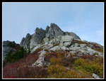
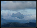
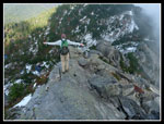
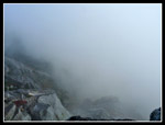
We headed over to the east ridge then scrambled up the slabs to the summit. It was 4:35 when we arrived. 2:20 minutes to get up and only 1:55 left until sunset. It looked like headlamps would be needed. It was sunny driving up and for the hike up. Now we were almost surrounded by clouds. Only White Chuck Mountain could be seen to the north. To the south the visibility was zero including straight down to Spada Lake. We took 15 minutes for dinner and were on our way down at 4:50. Because of the mud and wet rocks it was hard to travel any faster down than up. It actually took us a few minutes longer to get down to the lakes.
The hike out was non stop. No rest for the weary. We passed one couple at the first tarn while we were coming up and we saw a tent near a tarn above the main lakes from the summit of Bald. That accounted for the three other cars. We were alone for the hike out. The nearly 600' of uphill on the way back was not particularly appreciated though it was never steep. We passed the last meadow as the sky turned a bright red through the trees and the last of the sunlight receded.
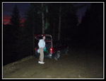
The trail finishes on the south side of the ridge so we had some light in open spots before heading back into dark forest. It was almost hiking by braille at the end. Just as we were resigned to pulling out our headlamps the trailhead came into sight. It was exactly 7:00 pm when we finished. Five minutes later it was pitch black. Well, we could have done Mt. Pilchuck and been home much earlier but instead we had a bit of an adventure. Gary checked a recent book with the trail included and checked his map. His verdict is 9-10 miles RT to the summit of Bald with 2800'+ in elevation gain. I guess I was just a little bit off. All in all, a fun half a day hike to lakes and a summit.
Click on thumbnails to get larger pictures.
Trips - 2009
Home
The road to the trailhead has been closed for three years due to washed out approaches to a bridge. It was just reopened about a month ago. We cruised down the Mountain Loop Highway and turned off right before Red Bridge. At about 1 1/2 miles we took the right fork. The road has been graded recently and is in great shape. Almost no potholes at all. One car was leaving as we arrived so we were able to park at the trailhead. There is not much room there though farther down the road are more spaces. A total of three cars were parked near the trailhead. One of them had a license plate border with "VIGGO" in big letters. I have had numerous emails via my website with someone with that name. Hmm...
At 2:15 we were on the trail. Recent volunteer work has removed most of the logs that fell on the trail in the last three years. The others can be climbed around of over without much trouble. With only 4 1/4 hours before sunset we set a pretty fast pace. Unfortunately the trail is muddier and rootier than I remembered. Much slower than a steeper smooth trail. The trail went up then down to some meadows. Far fewer berries than I found on a November visit. Surprising since this has been a great berry year and the trail has only been open a few weeks.
As we hiked along one meadow another hiker was coming out. Gary asked if he was Viggo. In fact he was. He looked at Gary trying to recall if they had met. He looked harder and couldn't figure out who he was. Then he turned to me and said "Jim!" A priceless moment. Years of emails and we met at last. He recognized me from photos on my site. We had a nice short conversation then we were back on our way.
We dropped to the lowest meadow then began the climb to Cutthroat Lakes. Snow had been here a week earlier. It was almost all gone now but the trail was very muddy. Lots of near falls on the slick mud and rocks. At long last we crested the ridge and reached the first tarn. Some very nice color here. The forest had blocked the sun down lower but the huckleberry bushes were backlit a fiery red. Some more dropping then a short climb brought us to the largest lake. It was almost 4:00 pm now, much later than I had planned on. Still a mile and 650' to climb to get up Bald Mountain.
Gary picked up the pace as we began the climb. Higher up there was snow on the trail but not more than a few inches. As we climbed above the notch in Bald's east ridge I wondered if we were still on the right trail. We hiked higher before descending towards the ridge. A trail sign remains though it is sitting on the ground now. We turned to the south side of Bald and nice views down to Spada Lake right below us. Clouds were blowing in and the lake was soon blotted out. The south side trail was not as brushy as I expected. We contoured below the summit then switchbacked up to the south ridge. From there it is not far to the summit.
We headed over to the east ridge then scrambled up the slabs to the summit. It was 4:35 when we arrived. 2:20 minutes to get up and only 1:55 left until sunset. It looked like headlamps would be needed. It was sunny driving up and for the hike up. Now we were almost surrounded by clouds. Only White Chuck Mountain could be seen to the north. To the south the visibility was zero including straight down to Spada Lake. We took 15 minutes for dinner and were on our way down at 4:50. Because of the mud and wet rocks it was hard to travel any faster down than up. It actually took us a few minutes longer to get down to the lakes.
The hike out was non stop. No rest for the weary. We passed one couple at the first tarn while we were coming up and we saw a tent near a tarn above the main lakes from the summit of Bald. That accounted for the three other cars. We were alone for the hike out. The nearly 600' of uphill on the way back was not particularly appreciated though it was never steep. We passed the last meadow as the sky turned a bright red through the trees and the last of the sunlight receded.
The trail finishes on the south side of the ridge so we had some light in open spots before heading back into dark forest. It was almost hiking by braille at the end. Just as we were resigned to pulling out our headlamps the trailhead came into sight. It was exactly 7:00 pm when we finished. Five minutes later it was pitch black. Well, we could have done Mt. Pilchuck and been home much earlier but instead we had a bit of an adventure. Gary checked a recent book with the trail included and checked his map. His verdict is 9-10 miles RT to the summit of Bald with 2800'+ in elevation gain. I guess I was just a little bit off. All in all, a fun half a day hike to lakes and a summit.
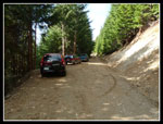 Walt Bailey Trailhead |
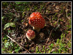 Mushrooms |
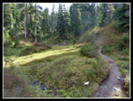 Small Meadow |
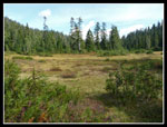 Big Meadow |
 First Snow |
 Tarn Reflection |
 Color Along Trail |
 Color Close Up |
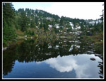 Cutthroat Reflection |
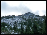 Bald Mountain |
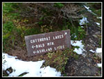 Trail Sign |
 Color & The Summit |
 Cloud On South Side |
 Spada Lake |
 Summit Is Above |
 Gary Near Summit |
 White Chuck Mountain |
 Lakes & Clouds |
 Cuthroat Lakes |
 East Rdige From Summit |
 Fewer Clouds |
 What Views? |
 Fall Color & Granite |
 Last Tarn Reflection |
 Dark On Our Return |
Trips - 2009
Home