5-25-09
Memorial Day was
the third and final day of our Methow Valley trip. I was up at 7:30 and
the sun crept over the ridge soon after. Kim and I took our time at
breakfast and it was 9:30 by the time we packed up camp and headed up
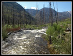
the Chewuch Valley. There is a lot of white water as the river drops
rapidly in many places. It has a dark green color unlike most rivers
I've seen. Our goal for the day was the Chewuch River Trail at the end
of the road. That was ten miles from our camp and thirty miles from
Winthrop. The valley was rapidly emptying as folks began to head home
from the holiday weekend. We passed many open campsites.
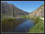
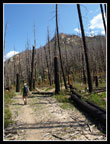
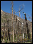
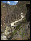
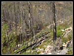
The road remains paved beyond our campsite and only the last half dozen or so miles are gravel. Lake and Andrew Creeks are now nearly the size of rivers themselves. Back in July of 2001 the Thirtymile Fire swept through the upper valley. It was a huge fire that blackened 9,300 acres and took the lives of four firefighters. Driving up the road we began to see partly blackened trees. That gave way to a silvered forest. Kim had hiked this trail before the fire. Again, like Driveway Butte, she would have the chance to compare before to after.
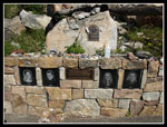
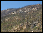
Kim picked out a boulder covered with Tweedy's lewisia. We saw much more of it along the uphill side of the road. The valley opened up a bit and the river widened when we reached the firefighters memorial. It is at the place where they lost their lives. Many items have been left there be loved ones and strangers. It's a sobering place to visit. After our visit we headed on to the end of the road. There are very few trees left beyond the memorial. There is green grass and brush but it will be awhile before forest returns.
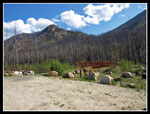
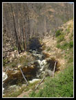
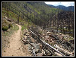
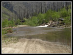
At the end of the road is a big parking lot much used by horsemen. This trail is one that travels deep into the Pasayten Wilderness. Maps show the current trailhead as the Thirtymile Campground and the trailhead across the river. The old car bridge burned up and the new bridge is for hikers and horses only. Just before the lot is a creek. The creek goes across the road. In fact the "puddle" it creates is at least 100' across. It's hard to tell how deep it is but Kim has a truck and we started on through. We had no trouble but I wouldn't try it with a car at this time. I'm guessing it was 8-10 inches deep.
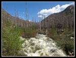
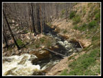
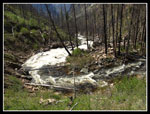
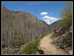
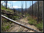
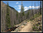
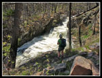
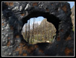
With our stops it was near 10:30 when we got started. No early morning starts for us. It was warm and getting warmer but there was a cool breeze that helped a lot.We crossed the bridge and started up the trail. Soon we reached a grassy spot that must have been the old trailhead. There is a sign still standing though the words have been burned off. A hole has also burned right through the sign. The trail ascends at a gentle rate. At first we climbed well above the creek then maintained 50 - 100 feet above it most of the day. The first section is no meandering stream. It is all crazy white water spitting out lots of noise.
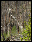
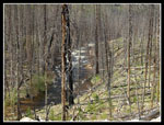
Forest must have blocked much of the views at one time. Now the river and the surrounding ridges are wide open. As with the other trails we hiked this weekend logs have not yet been cut out. We clambered up and over or around probably 30 logs on our trip. The trail seems wide enough to have been a road at one time. In some places time and slides have narrowed the tread substantially though it is never too narrow. Logs down in the narrow spots would make this trail impossible for horses until some cutting is done.
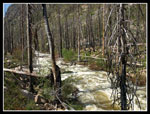
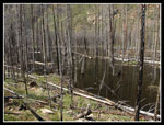
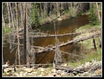
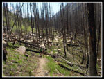
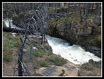
As we ascended the river makes an abrupt turn of more than 90 degrees. Lots of white water here. Around the bend the river changes character and becomes a wide and very slow moving. It's a bit of a scramble but one could get down to the shore here. The river soon bends and the trail turns to the right. Along here was another surprise. Logs have fallen and blocked much of the river flow. A big lake has been created. Silvered trees stand deep in the water. It takes a good imagination to see a narrow river running through a deep green forest. Now it's a lake with branchless silver spires standing in the water.
A patch of surviviing evergreens made for a shady lunch spot. The old road drops down towards the river here. The trail continues mostly level. The narrow valley widens here. Just ahead Kim tried to imagine where she had camped near the river in a flat area. Just a jumple of silve logs and spires now with the river as wide as a lake. When Kim visited she went ahead to Chewuch Falls though the water level was not high. This day it was plenty high. We decided to go ahead a little longer and look for the falls.
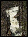
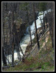
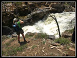
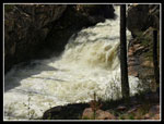
There were half a dozen downed logs in one spot and we considered turning around. We chose to go a little further. The river narrows to a slot gorge and the trail climbs above. We could now hear the loud noise of cascading water but could not see much. It was not too tough to crawl over logs to reach the mouth of the gorge. We decided to go up to the start of the gorge. We left the trail where the white water began and climbed down to the start of the fun. You could feel the power of the water. It was too loud to talk more than a few feet apart. What a spot! This too was forest a few years ago. Now just grass and silvered old trees.
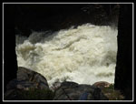
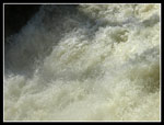
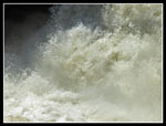
The gorge is not very wide. All that water was packed into the narrow chasm. The water was green and white and yellow. Kim was filming a movie when I looked up and saw a couple of hikers coming down. What are the odds? The only people we saw all day and it was off trail. We dropped down alongside the river to a great viewing spot. The only live evergreen tree on our side of the river was right there. Some shade and a flat spot to view the angry river. This spot was well worth the hike in. I guesstimate that our turn around point at the falls was a little less than three miles up the trail.
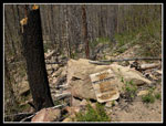
After nearly an hour at the falls we had to leave. We still had to drive all the way back to Seattle. As I started out I saw a metal box. It was sealed with no openings. Heavy metal and maybe 10" x 8" x 6". There was a "t" shaped piece of metal next to it that looked like it was meant to be driven into the ground. I have no idea what it is. The hike back was mostly at a gentle downhill grade. The sun was getting to me a bit but it was not that far to the truck. There were no cars in the lot. The one couple were the only folks we saw all day.
That big puddle across the road proved to be a great spot to clean up. Lots of cool clean water without having to clmib down to the river. It was late enough in the day that we had no holday traffic problems. Dinner was at the Marblemount Diner. They stayed open late as we did not arrive until 7:15 pm. I was home by 10:30. This was a fun weekend. We had a summit and some elevation gain on day one. Two river walks on day two. One in a burn and one in a living forest. Day three was a both wild and placid river though one huge burn. Throw in a powerful falls and you have quite a day. Best of all, all four trails were new for me. I love to get out and hike areas I had not visited. All in all, a great Memorial Day Weekend.
Kim's report is here: Nwhikers Report & Photos
Click on thumbnails to get larger pictures.
Trips - 2009
Home
The road remains paved beyond our campsite and only the last half dozen or so miles are gravel. Lake and Andrew Creeks are now nearly the size of rivers themselves. Back in July of 2001 the Thirtymile Fire swept through the upper valley. It was a huge fire that blackened 9,300 acres and took the lives of four firefighters. Driving up the road we began to see partly blackened trees. That gave way to a silvered forest. Kim had hiked this trail before the fire. Again, like Driveway Butte, she would have the chance to compare before to after.
Kim picked out a boulder covered with Tweedy's lewisia. We saw much more of it along the uphill side of the road. The valley opened up a bit and the river widened when we reached the firefighters memorial. It is at the place where they lost their lives. Many items have been left there be loved ones and strangers. It's a sobering place to visit. After our visit we headed on to the end of the road. There are very few trees left beyond the memorial. There is green grass and brush but it will be awhile before forest returns.
At the end of the road is a big parking lot much used by horsemen. This trail is one that travels deep into the Pasayten Wilderness. Maps show the current trailhead as the Thirtymile Campground and the trailhead across the river. The old car bridge burned up and the new bridge is for hikers and horses only. Just before the lot is a creek. The creek goes across the road. In fact the "puddle" it creates is at least 100' across. It's hard to tell how deep it is but Kim has a truck and we started on through. We had no trouble but I wouldn't try it with a car at this time. I'm guessing it was 8-10 inches deep.
With our stops it was near 10:30 when we got started. No early morning starts for us. It was warm and getting warmer but there was a cool breeze that helped a lot.We crossed the bridge and started up the trail. Soon we reached a grassy spot that must have been the old trailhead. There is a sign still standing though the words have been burned off. A hole has also burned right through the sign. The trail ascends at a gentle rate. At first we climbed well above the creek then maintained 50 - 100 feet above it most of the day. The first section is no meandering stream. It is all crazy white water spitting out lots of noise.
Forest must have blocked much of the views at one time. Now the river and the surrounding ridges are wide open. As with the other trails we hiked this weekend logs have not yet been cut out. We clambered up and over or around probably 30 logs on our trip. The trail seems wide enough to have been a road at one time. In some places time and slides have narrowed the tread substantially though it is never too narrow. Logs down in the narrow spots would make this trail impossible for horses until some cutting is done.
As we ascended the river makes an abrupt turn of more than 90 degrees. Lots of white water here. Around the bend the river changes character and becomes a wide and very slow moving. It's a bit of a scramble but one could get down to the shore here. The river soon bends and the trail turns to the right. Along here was another surprise. Logs have fallen and blocked much of the river flow. A big lake has been created. Silvered trees stand deep in the water. It takes a good imagination to see a narrow river running through a deep green forest. Now it's a lake with branchless silver spires standing in the water.
A patch of surviviing evergreens made for a shady lunch spot. The old road drops down towards the river here. The trail continues mostly level. The narrow valley widens here. Just ahead Kim tried to imagine where she had camped near the river in a flat area. Just a jumple of silve logs and spires now with the river as wide as a lake. When Kim visited she went ahead to Chewuch Falls though the water level was not high. This day it was plenty high. We decided to go ahead a little longer and look for the falls.
There were half a dozen downed logs in one spot and we considered turning around. We chose to go a little further. The river narrows to a slot gorge and the trail climbs above. We could now hear the loud noise of cascading water but could not see much. It was not too tough to crawl over logs to reach the mouth of the gorge. We decided to go up to the start of the gorge. We left the trail where the white water began and climbed down to the start of the fun. You could feel the power of the water. It was too loud to talk more than a few feet apart. What a spot! This too was forest a few years ago. Now just grass and silvered old trees.
The gorge is not very wide. All that water was packed into the narrow chasm. The water was green and white and yellow. Kim was filming a movie when I looked up and saw a couple of hikers coming down. What are the odds? The only people we saw all day and it was off trail. We dropped down alongside the river to a great viewing spot. The only live evergreen tree on our side of the river was right there. Some shade and a flat spot to view the angry river. This spot was well worth the hike in. I guesstimate that our turn around point at the falls was a little less than three miles up the trail.
After nearly an hour at the falls we had to leave. We still had to drive all the way back to Seattle. As I started out I saw a metal box. It was sealed with no openings. Heavy metal and maybe 10" x 8" x 6". There was a "t" shaped piece of metal next to it that looked like it was meant to be driven into the ground. I have no idea what it is. The hike back was mostly at a gentle downhill grade. The sun was getting to me a bit but it was not that far to the truck. There were no cars in the lot. The one couple were the only folks we saw all day.
That big puddle across the road proved to be a great spot to clean up. Lots of cool clean water without having to clmib down to the river. It was late enough in the day that we had no holday traffic problems. Dinner was at the Marblemount Diner. They stayed open late as we did not arrive until 7:15 pm. I was home by 10:30. This was a fun weekend. We had a summit and some elevation gain on day one. Two river walks on day two. One in a burn and one in a living forest. Day three was a both wild and placid river though one huge burn. Throw in a powerful falls and you have quite a day. Best of all, all four trails were new for me. I love to get out and hike areas I had not visited. All in all, a great Memorial Day Weekend.
Kim's report is here: Nwhikers Report & Photos
 Chewuch At Memorial |
 Firefighters Memorial |
 Trailhead |
 Upriver From Bridge |
 Downriver From Bridge |
 Starting Up Trail |
 Spiral Tree |
 Many Color River |
 Narrowing Canyon |
 90 Degree Turn |
 Slow Then Ripping |
 Sharp Turn |
 Once A Forest |
 Road To Trail |
 A Few Clouds |
 Burnt To The Ridge Top |
 Dammed Lake |
 Downed Logs |
 Wilderness Sign |
 Brown Water |
 Surviving Evergreens |
 Rocks & Logs |
 First Look At Falls |
 Closer Look |
 Zoomed Middle Falls |
 White Water |
 Kim At Top Of Falls |
 Looking Down Falls |
 Middle Falls |
 Boiling River |
 Roiling & Boiling |
 Kim At Middle Falls |
 Total Burn |
 View Through Sign |
 Creek Over Road |
Trips - 2009
Home