01-30-11
I
bought a copy of Footsore 1 in the early 1980s. In the next few years I
hiked many of the close in destinations. McDonald Mountain is one that
I read about and just never managed to get to. It was time, after
nearly 30 years, to correct that. A report of an aborted trip by Type
E provided the impetus to give it a try. The start described in
Footsore seems to no longer work. Several reports mentioned
problems. A different old road is now the starting point. It rained all
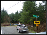
day on Saturday so I chose Sunday. I drove south to Highway 169 heading
out of Renton. At the Kent-Kangley Road I turned left. When the road
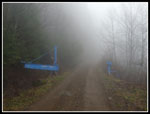
reaches the face of the mountains it turns left to the north. There is
a blue gate on the turn that is the start of the route. A sign shows
Kent-Kangley Road and 346th Ave SE. There was one truck parked by the
gate at 9:35 when I arrived.
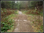
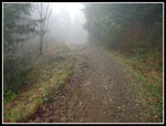
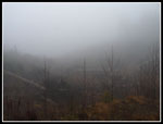
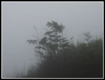
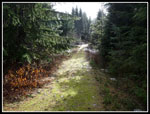
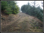
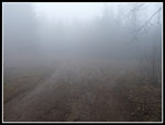
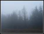
It was clearing in Seattle but misty with low clouds when I started out. The first mile is on a rocky old road. There are a dozen or more small berms cut across the road. The grade is a steady climb. Not too steep but very consistent. At 1.4 miles a grassy road goes straight ahead and the main route switches back. The grade is suddenly smooth and much easier walking. Soon I entered a clear cut. Reports mention good views out from here. I could barely see 50 feet. I passed a returning couple with dogs in the first mile. A little later I passed a single hiker with dogs also coming out. That was it for the whole day.
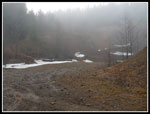
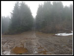
At 2.1 miles I met the main road. Wider and very smooth it too was easy to hike on. Several roads turned off but the most traveled, and correct, route continues higher. I reached another gate and this one was open. At 3.3 miles I reached the quarry mentioned in most reports. The main road continues straight ahead and quickly meets a yellow gate. The route to the tower angles up to the right and has a blue gate. I began to see a little snow as I neared 3000' in elevation. The road switchbacks several times and reached the building and tower at 4.18 miles per my GPS. To that point I had gained 2300'. I took a short break here. There are a few spots with views out to the west.
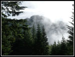
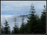
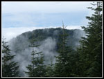
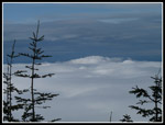
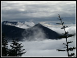
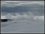
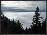
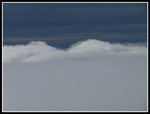
It was still cloudy but I was now high enough to look down on a layer of puffy cotton like clouds. There was even a small donut hole of blue sky overhead for a moment. I was only about a little less than 400' below the actual summit farther south along the ridge. I had read that I still had 1200' of gain. Must be some ups and downs. Yes here are. A short drop down the road and I started up the older grassy and narrower road heading south. I put on rain pants, a rain coat, and gaiters expecting the road to be overgrown and wet. It was really not bad at all.
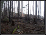
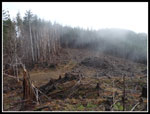
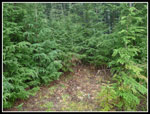
I dropped down to a landing with old logging slash and metal cables laying around. The road drops some more then begins to climb. The drop and climb were minimal. I was looking for the spot of the old fire lookout but I did not find it. I believe it was south of the current communications tower. I soon reached another small landing that is slowly getting filled in with small trees. Tightly packed 8-10 foot evergreens surround the open space. With no obvious trail I pushed into the green wall and within 20' I reached older open forest.
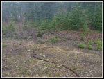
A short bootpath ran right along the crest of the ridge. In just a few minutes I saw the clear cut I had read about. I knew that there was a road somewhere on the other side of the slash. Forest is just to the left. I chose to climb over a series of bit logs then wound around stumps and slash. I dropped down to a landing and then climbed up the other side on a minimal road. More climbing over logs and I reached a road running perpendicular. It is impossible to not run into the road. I turned right and continued on a wider grassy road.
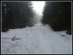
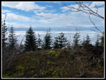
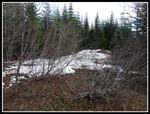
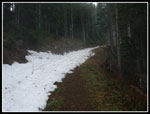
The route began to drop again. This drop was about 300'. My GPS made it easy to take the correct road at the junctions. Several roads on the map were completely overgrown now anyway. There were a few patches of snow but they were never more than 3-4 inches deep. At the low point I took off my rain gear as I was sweating up a storm. The climb is only about 450' to the summit. The last 1/4 mile was all snow. It was now 4-8 inches deep. I was postholing half the time. The road turns to the right reaching the ridge then continues around to the west side. Here I found an opening with views to the west and southwest and some dry ground. Time for lunch.
It took me 1:20 to hike the 2 1/2 miles from the tower to the real summit. The last part was slow going in the snow. Sun was shining on and off through the clouds. The temperature was 36 degrees but there was no wind, a little sun, and it was very comfortable. After lunch I packed up and started down. It was only 1:00 pm so I had plenty of time to hike down before dark. It was 6.74 miles to the real summit. Descending the snow was much faster. When I neared the clear cut I chose to continue down the road rather than leave the road where I had earlier reached it.
The road continued to drop and I turned left and climbed back to the landing at the bottom of the clear cut. This was easier as I did not have many logs to climb over. I chose to not follow my route straight through the clear cut. Instead, I followed the road as it headed west then turned to the north. The road quickly ended and a boot path began. I then angled to the right and went around all the downed logs. I met back up with the boot path on the ridge crest and soon went through the green wall and was back on the other road.
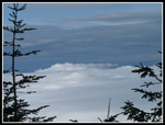
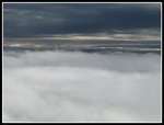
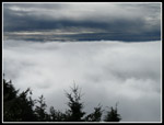
I drop and climb brought me back to the tower site. One more stop to check out the views. Still just a layer of clouds below. My thermometer read 40 degrees, the high of the day. It only took 58 minutes from the summit to the tower. I headed down and before reaching the quarry I was back in the cloudy mist with visibility of 50' at most. A check of my thermometer showed it was down to 33 degrees, the low of the day. The rest of the descent went fast. It took 1:20 to reach my car.
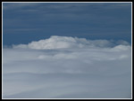
This was a fun day. 13.5 miles with 3600' of gain was a full day. I hiked rocky road, smooth road, grassy road, a ridge crest boot path, through a short clear cut, and in soft snow. The view down to the sunny layer of clouds was neat. Now I just need to come back on a clear day and see the views I missed. In summary, this route is a good workout, has viewpoints, and few people. Good enough for me.
Click on thumbnails to get
larger pictures.
Trips - 2011
Home
It was clearing in Seattle but misty with low clouds when I started out. The first mile is on a rocky old road. There are a dozen or more small berms cut across the road. The grade is a steady climb. Not too steep but very consistent. At 1.4 miles a grassy road goes straight ahead and the main route switches back. The grade is suddenly smooth and much easier walking. Soon I entered a clear cut. Reports mention good views out from here. I could barely see 50 feet. I passed a returning couple with dogs in the first mile. A little later I passed a single hiker with dogs also coming out. That was it for the whole day.
At 2.1 miles I met the main road. Wider and very smooth it too was easy to hike on. Several roads turned off but the most traveled, and correct, route continues higher. I reached another gate and this one was open. At 3.3 miles I reached the quarry mentioned in most reports. The main road continues straight ahead and quickly meets a yellow gate. The route to the tower angles up to the right and has a blue gate. I began to see a little snow as I neared 3000' in elevation. The road switchbacks several times and reached the building and tower at 4.18 miles per my GPS. To that point I had gained 2300'. I took a short break here. There are a few spots with views out to the west.
It was still cloudy but I was now high enough to look down on a layer of puffy cotton like clouds. There was even a small donut hole of blue sky overhead for a moment. I was only about a little less than 400' below the actual summit farther south along the ridge. I had read that I still had 1200' of gain. Must be some ups and downs. Yes here are. A short drop down the road and I started up the older grassy and narrower road heading south. I put on rain pants, a rain coat, and gaiters expecting the road to be overgrown and wet. It was really not bad at all.
I dropped down to a landing with old logging slash and metal cables laying around. The road drops some more then begins to climb. The drop and climb were minimal. I was looking for the spot of the old fire lookout but I did not find it. I believe it was south of the current communications tower. I soon reached another small landing that is slowly getting filled in with small trees. Tightly packed 8-10 foot evergreens surround the open space. With no obvious trail I pushed into the green wall and within 20' I reached older open forest.
A short bootpath ran right along the crest of the ridge. In just a few minutes I saw the clear cut I had read about. I knew that there was a road somewhere on the other side of the slash. Forest is just to the left. I chose to climb over a series of bit logs then wound around stumps and slash. I dropped down to a landing and then climbed up the other side on a minimal road. More climbing over logs and I reached a road running perpendicular. It is impossible to not run into the road. I turned right and continued on a wider grassy road.
The route began to drop again. This drop was about 300'. My GPS made it easy to take the correct road at the junctions. Several roads on the map were completely overgrown now anyway. There were a few patches of snow but they were never more than 3-4 inches deep. At the low point I took off my rain gear as I was sweating up a storm. The climb is only about 450' to the summit. The last 1/4 mile was all snow. It was now 4-8 inches deep. I was postholing half the time. The road turns to the right reaching the ridge then continues around to the west side. Here I found an opening with views to the west and southwest and some dry ground. Time for lunch.
It took me 1:20 to hike the 2 1/2 miles from the tower to the real summit. The last part was slow going in the snow. Sun was shining on and off through the clouds. The temperature was 36 degrees but there was no wind, a little sun, and it was very comfortable. After lunch I packed up and started down. It was only 1:00 pm so I had plenty of time to hike down before dark. It was 6.74 miles to the real summit. Descending the snow was much faster. When I neared the clear cut I chose to continue down the road rather than leave the road where I had earlier reached it.
The road continued to drop and I turned left and climbed back to the landing at the bottom of the clear cut. This was easier as I did not have many logs to climb over. I chose to not follow my route straight through the clear cut. Instead, I followed the road as it headed west then turned to the north. The road quickly ended and a boot path began. I then angled to the right and went around all the downed logs. I met back up with the boot path on the ridge crest and soon went through the green wall and was back on the other road.
I drop and climb brought me back to the tower site. One more stop to check out the views. Still just a layer of clouds below. My thermometer read 40 degrees, the high of the day. It only took 58 minutes from the summit to the tower. I headed down and before reaching the quarry I was back in the cloudy mist with visibility of 50' at most. A check of my thermometer showed it was down to 33 degrees, the low of the day. The rest of the descent went fast. It took 1:20 to reach my car.
This was a fun day. 13.5 miles with 3600' of gain was a full day. I hiked rocky road, smooth road, grassy road, a ridge crest boot path, through a short clear cut, and in soft snow. The view down to the sunny layer of clouds was neat. Now I just need to come back on a clear day and see the views I missed. In summary, this route is a good workout, has viewpoints, and few people. Good enough for me.
 Trailhead |
 Berm Across Road/Trail |
 Entering The Mist |
 Near Zero Visibility |
 Misty Tree |
 Open Gate |
 Clearer At The Quarry |
 Right Turn To Tower |
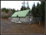 Summit Building |
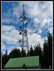 Tower & Blue Sky |
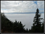 Sea Of Low Clouds |
 Bright Clouds |
 Old Grassy Road |
 Logging Remnants |
 Edge Of Clear Cut |
 Crossing Clear Cut |
 Descending Old Road |
 Real Summit Ahead |
 Deeper Snow Near Top |
 Summit Viewpoint |
 North Summit |
 Sun Shines On Clouds |
 Tower At Right |
 Puffy Clouds |
 Blue, Gray, & White |
 McDonald Summit |
 Swirling Clouds |
 Airplane Window View |
 Ascending Road |
 Wall Of Green |
 Tower Viewpoint |
 More Puffy Clouds |
 Cloud Peaks |
 Last Cloud Shot |
 Back In The Mist |
 What View? |
Trips - 2011
Home