6-19-11
Time
for a solo scramble in the
Teanaway. Drizzle all the way from Seattle to Easton then nothing but
blue sky. The long drive was well worth it to get a spring day while
the west side was under clouds. First look at Mt. Stuart from Highway
970 showed not a cloud to be seen. Teanaway Road is regraded and
smooth. Stafford Road is it's usual rocky post holy self. Found two
cars
in the lot at 8:35 am. Zero clouds so it was shorts and short sleeves
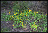
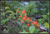
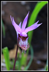
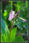
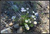
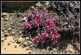
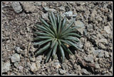
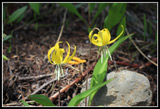
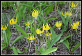
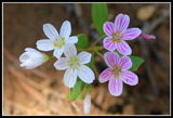
from the start. Lots of early season wildflowers before the snow.
Trillium is almost done but everything else is in full bloom. Vanilla
leaf, silver crown, arnica, red and orange paintbrush, calypso orchids,
lupine, glacier lilies, spring beauty, shooting stars, and more. This
is not a great flower hike but there are plenty right now.
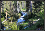
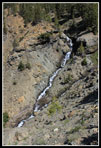
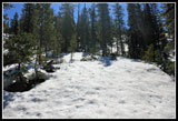
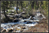
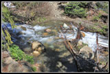
Flower opportunities slowed me down. The creek is more like a river right now. It is flowing loud and fast. Side creeks were not a big problem, with one exception, though higher up the trail is a creek in many places. Half a dozen trees down across the trail though at least one was cut out during the day. Signs of recent trail work in one spot too. A couple miles up I passed three backpackers heading out. They were the only people I saw all day long. At about 2 1/2 miles I found 8 feet of snow across the previously bare trail. A big avalanche came down and that snow pile will not be melting out for a while. It was easy enough to climb up and over it. There are a number of bent and broken trees too.
Just beyond the snow the ground is littered with glacier lilies and spring beauty. Literally white and yellow ground cover. Probably the thickest covering of spring beauty I have ever seen. Next comes the series of long gentle switchbacks. The upper couple crossed another area of snow. Clear before, after, above, and below. It's not hard to follow the route over the snow. That brought me to the creek crossing. It is high in the morning and higher in the afternoon. A narrow log reaches part way but is slick and nearly underwater. I chose to do a counter clockwise loop and that meant heading straight up before crossing the creek.
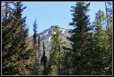
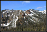
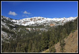
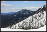
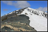
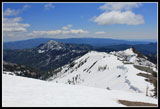
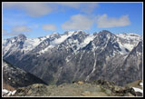
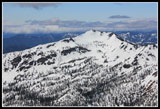
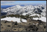
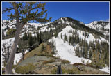
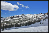
It was 3.6 miles with 1700' of gain to the creek. Trailhead is at 3100'. Creek crossing is at 4800'. The saddle between Navaho and Little Navaho is at 6000'. The summit is at 7223'. It is 1200' to the saddle in about 1/2 mile. Steep, off trail, and not for everyone. The trail gets you up Navaho with a lot less effort. I found a lot of western anemone and millions more spring beauty on this climb. The creek descends deep into a canyon right below. Views behind me to Earl Peak opened up as I rose above the trees.
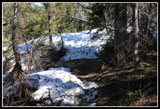
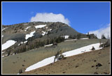
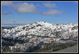
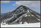
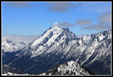
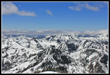
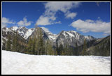
Half way up the slope was mostly snow covered. Sometimes too soft and sometimes too hard it was not the best conditions. I put on microspikes and that helped. For some reason I just did not have much energy after leaving the trail. I'm not sure why but it was slow and slower the rest of the way up. Maybe it was the hours in bright sunshine for a change. At long last I reached the saddle and took a break. Little Navaho is right above but I did not have the energy to tackle it again this day. Three Brothers is across the valley. The scramble ridge is 2/3rds snow free. Miller Peak is visible around Little Navaho.
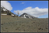
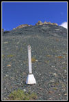
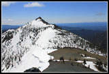
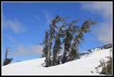
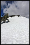
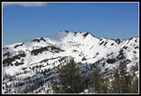
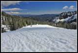
The next part is climbing up scree. More slow and slower. Atop that is some easy rock scrambling to the ridge top. Navaho Peak finally came into view. The usual cornices on the right side of the ridge. It's pretty level over to where the County Line Trail cuts through. Though some of the ground is bare I did not find the trail. The rest of the way to the summit is on moderately steep snow. Though I carried an ice axe it never came off my pack. Near the top I had to weave through trees and had the inevitable post holing. I'd guess there is still 6+ feet of snow near the top.
I was very happy to finally run out of uphill. The 1.8 miles with 2500' of gain from the creek took longer than the first 3.6 miles to the creek. It was 1:00 pm when I reached the summit. Some clouds began to drift in on my climb up the ridge but there was still a lot of blue sky. A cold breeze brought out by jacket but not enough to chase me off the top. I found some footprints part way up the ridge. Looking down there were many more heading towards Navaho Pass. Still no summit register. It seems to come and go regularly. I spent half an hour on top and headed down at 1:30. It was nice to have gravity working for me. Tracks led to the right and onto bare dirt/scree where the summer "trail" goes. I chose to stay farther left on the ridge top and descend on snow.
At the bare spot where the Navaho trail leaves the County Line trail I stopped to remove microspikes. It took only 30 minutes to reach Navaho Pass. 1200' lost in .90 miles. Below the pass the bare area where almost nothing grows was all snow covered. I followed tracks and missed the meadow entirely. Using the GPS I was able to find the summer trail on the first long switchback to the left. Only 100' or so below the meadow the trail was mostly snow free. It is wet with a number of side creek crossings. More shooting stars along here and a lot of glacier lilies. The endless long gentle switchbacks finally brought me down to the Standup Creek trail junction.
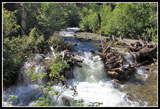
You must cross Stafford Creek immediately on that trail and it is a deep ford at this time. Only 4.1 miles to go from the junction. One tree is down right on the trail. You can go alongside it but it must be moved before horses can get through easily. All those side creeks crossed and recrossed above now run down a section of trail. When they finally drop to Stafford Creek the trail dries out. The bare trail goes back into forest and snow returns. This is my least favorite part in spring. Rotten snow is up to 3 feet deep and I managed to post hole along here. I even got in one full body post hole. I went in right up to my waist. This part is short and I soon reached the big creek to close the loop.
The creek was higher as I expected. Too high to get through without burying my boots almost knee deep. I chose to do a barefoot ford for the third time in the past four weeks. One of the side effects of a deep late spring snow pack. From there it was just a nice stroll the last 3.6 miles. More flower photos and a much quicker pace. It was 5:00 pm when I reached the car. The spot forecast high for the trailhead was about 60 degrees but it felt like 70+. Spring finally arrived in the Teanaway.
Driving home it was dark and cloudy in the mountains with light rain much of the way from the crest to North Bend. I always enjoy a sunny day on the east side when it rains both coming and going on the west side. For the day I hiked 12 miles with 4300' of gain. I saw only one group in 8 hours. Not bad. Navaho is a real favorite and even more interesting as a loop over the summit instead of up and down the same route. As with many Teanaway treks your imagination is the key to finding interesting routes.
Click on thumbnails to get
larger pictures.
Trips - 2011
Home
Flower opportunities slowed me down. The creek is more like a river right now. It is flowing loud and fast. Side creeks were not a big problem, with one exception, though higher up the trail is a creek in many places. Half a dozen trees down across the trail though at least one was cut out during the day. Signs of recent trail work in one spot too. A couple miles up I passed three backpackers heading out. They were the only people I saw all day long. At about 2 1/2 miles I found 8 feet of snow across the previously bare trail. A big avalanche came down and that snow pile will not be melting out for a while. It was easy enough to climb up and over it. There are a number of bent and broken trees too.
Just beyond the snow the ground is littered with glacier lilies and spring beauty. Literally white and yellow ground cover. Probably the thickest covering of spring beauty I have ever seen. Next comes the series of long gentle switchbacks. The upper couple crossed another area of snow. Clear before, after, above, and below. It's not hard to follow the route over the snow. That brought me to the creek crossing. It is high in the morning and higher in the afternoon. A narrow log reaches part way but is slick and nearly underwater. I chose to do a counter clockwise loop and that meant heading straight up before crossing the creek.
It was 3.6 miles with 1700' of gain to the creek. Trailhead is at 3100'. Creek crossing is at 4800'. The saddle between Navaho and Little Navaho is at 6000'. The summit is at 7223'. It is 1200' to the saddle in about 1/2 mile. Steep, off trail, and not for everyone. The trail gets you up Navaho with a lot less effort. I found a lot of western anemone and millions more spring beauty on this climb. The creek descends deep into a canyon right below. Views behind me to Earl Peak opened up as I rose above the trees.
Half way up the slope was mostly snow covered. Sometimes too soft and sometimes too hard it was not the best conditions. I put on microspikes and that helped. For some reason I just did not have much energy after leaving the trail. I'm not sure why but it was slow and slower the rest of the way up. Maybe it was the hours in bright sunshine for a change. At long last I reached the saddle and took a break. Little Navaho is right above but I did not have the energy to tackle it again this day. Three Brothers is across the valley. The scramble ridge is 2/3rds snow free. Miller Peak is visible around Little Navaho.
The next part is climbing up scree. More slow and slower. Atop that is some easy rock scrambling to the ridge top. Navaho Peak finally came into view. The usual cornices on the right side of the ridge. It's pretty level over to where the County Line Trail cuts through. Though some of the ground is bare I did not find the trail. The rest of the way to the summit is on moderately steep snow. Though I carried an ice axe it never came off my pack. Near the top I had to weave through trees and had the inevitable post holing. I'd guess there is still 6+ feet of snow near the top.
I was very happy to finally run out of uphill. The 1.8 miles with 2500' of gain from the creek took longer than the first 3.6 miles to the creek. It was 1:00 pm when I reached the summit. Some clouds began to drift in on my climb up the ridge but there was still a lot of blue sky. A cold breeze brought out by jacket but not enough to chase me off the top. I found some footprints part way up the ridge. Looking down there were many more heading towards Navaho Pass. Still no summit register. It seems to come and go regularly. I spent half an hour on top and headed down at 1:30. It was nice to have gravity working for me. Tracks led to the right and onto bare dirt/scree where the summer "trail" goes. I chose to stay farther left on the ridge top and descend on snow.
At the bare spot where the Navaho trail leaves the County Line trail I stopped to remove microspikes. It took only 30 minutes to reach Navaho Pass. 1200' lost in .90 miles. Below the pass the bare area where almost nothing grows was all snow covered. I followed tracks and missed the meadow entirely. Using the GPS I was able to find the summer trail on the first long switchback to the left. Only 100' or so below the meadow the trail was mostly snow free. It is wet with a number of side creek crossings. More shooting stars along here and a lot of glacier lilies. The endless long gentle switchbacks finally brought me down to the Standup Creek trail junction.
You must cross Stafford Creek immediately on that trail and it is a deep ford at this time. Only 4.1 miles to go from the junction. One tree is down right on the trail. You can go alongside it but it must be moved before horses can get through easily. All those side creeks crossed and recrossed above now run down a section of trail. When they finally drop to Stafford Creek the trail dries out. The bare trail goes back into forest and snow returns. This is my least favorite part in spring. Rotten snow is up to 3 feet deep and I managed to post hole along here. I even got in one full body post hole. I went in right up to my waist. This part is short and I soon reached the big creek to close the loop.
The creek was higher as I expected. Too high to get through without burying my boots almost knee deep. I chose to do a barefoot ford for the third time in the past four weeks. One of the side effects of a deep late spring snow pack. From there it was just a nice stroll the last 3.6 miles. More flower photos and a much quicker pace. It was 5:00 pm when I reached the car. The spot forecast high for the trailhead was about 60 degrees but it felt like 70+. Spring finally arrived in the Teanaway.
Driving home it was dark and cloudy in the mountains with light rain much of the way from the crest to North Bend. I always enjoy a sunny day on the east side when it rains both coming and going on the west side. For the day I hiked 12 miles with 4300' of gain. I saw only one group in 8 hours. Not bad. Navaho is a real favorite and even more interesting as a loop over the summit instead of up and down the same route. As with many Teanaway treks your imagination is the key to finding interesting routes.
 Lots Of Arnica |
 Indian Paintbrush |
 More Flowers |
 Calypso Orchid |
 Stafford Creek |
 First View Of Little Navaho |
 Avalanche Debris |
 Shooting Star |
 Western Anemone |
 Douglasia |
 Ridge Across Valley |
 Creek In Gorge |
 First Look At Earl Peak |
 Now On Snow |
 Ridge To Navaho |
 Three Brothers Over Pass |
 Miller Peak |
 Post #5 |
 Saddle & Little Navaho |
 Earl & Stafford Valley |
 First View Of Navaho |
 Three Brothers |
 Wind Blown Trees |
 Bitterroot |
 Looking Down Ridge |
 Snow Climb To Summit |
 Mt. Stuart |
 Stuart Range |
 Above Earl Peak |
 View To Navaho Pass |
 Heart Of The Teanaway |
 View On Descent |
 Navaho Pass |
 Navaho Pass View |
 Barren Spot |
 Blue Sky |
 Two Glacier Lilies |
 Field Of Glacier Lilies |
 Spring Beauty |
 Standup Crossing |
 Barefoot Ford |
 Stafford Creek Cascade |
Trips - 2011
Home