9/03-05/11
Gary
came up with a backpacking
trip for Labor Day Weekend. John and I joined him. The plan was to hike
up Poe Mountain then follow the Poet Ridge High Route to the Pacific
Crest Trail at Kodak Peak. From there we would scramble up Indian Head
Peak. On day three we would summit Kodak Peak then hike south on the
PCT and back via Cady Ridge. The only part I had hiked previously was
the along the PCT from Dishpan Gap to Indian Pass. We had very little
info on the Poet Ridge route. The trail is mentioned in a few reports
up to Longfellow Peak. It also has a little info suggesting a pretty
good trail from The PCT to Bryant Peak. The middle section has almost
no info anywhere online. I will rectify that. Knowing the route was not
clear made for a bit of an adventure. Now on to the report.
Day 1
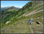
I met Gary and John in Bothell and we headed east on Highway 2. At Coles Corner we turned towards Lake Wenatchee. The road rounds the lake and heads back west. At the road end is the Wenatchee Ford trailhead. Half the trailhead area is marked "no parking" leaving only eight official spaces for a very popular trailhead. It is more popular now that the Suiattle, Whitechuck, and NF Sauk roads on the west side of the crest are closed. We were early enough to snag a spot. By 9:05 we were on the trail. 3/8th of a mile and 200' feet higher I realized I had left my camera in the car. I was rewarded with a dash back and an extra 3/4 miles and 200' of gain for the trip. After that faux pas it was time to get down to a short steep ascent of Poe Mountain.
Not knowing if we would find any water along the ridge we brought plenty. That pushed my pack weight up to about 29 lbs. Also, we were not sure if the route traversed the east side of the ridge at any point so we brought ice axes. They were never used. There was almost no semi current information on the area. The trail is well graded and we made good time. The cool morning air helped. It was only 41 degrees when we started. It felt a whole lot warmer high on Poe Mountain. Poe Mountain is 3000' up in only three miles of trail. We followed the trail to where is seemed to disappear in a small meadow just below the ridge. A faint trail had two rocks across it. We knew the Poet Ridge route would be on top of the ridge so we headed straight up. Indeed a narrow boot path was found. We turned right and soon met the real trail coming up from the meadow.
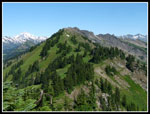
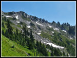
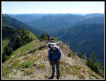
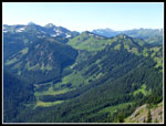
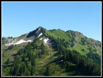
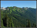
We dropped packs and did the last short climb without the weight. Great views from the old lookout site on the summit. Three miles down. We could see much of the remaining 7 miles to the junction with the PCT below Kodak Peak. Add one more lookout site to the many I have already visited. We soon dropped to our packs and started out on the Poet Ridge "trail". The route goes by Longfellow and Bryant Peaks and a side ridge goes to Whittier Peak. That one was not in the plan. My GPS map showed the route going right along the ridge top. John's paper map showed it all over the ridge. Neither proved to be very accurate. The first part was indeed on the ridge crest but we soon dropped to the west side and stayed there most of the way.
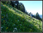
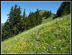
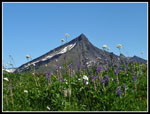
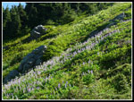
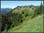
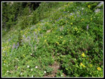
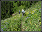
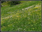
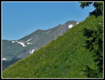
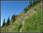
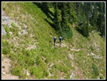
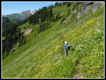
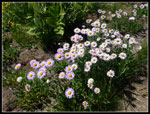
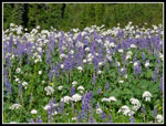
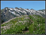
The flower show began immediately and never let up for the whole three days. Some were a little past prime but the bulk of the wildflowers were right near their peak. The meadows constituted the whole sides of the ridge. They went on and on and on. I have seen more intense colors and denseness but for sheer volume of wildflowers I doubt I have ever done a hike to match this one. The tread was easy to follow though narrow much of the way. With the steep slope you did not want to slip and fall. With moderate care the trail was fine.
As we neared Longfellow Peak we came to a junction. A level traverse ahead or a slightly more used trail switchbacking higher. We chose to go up. The route leveled then began to descend underneath the peak. We found some snow fields here. Not hazardous just fun to boot ski down. Much to my surprise we met a group here. They were hunters out scouting for the coming season. They had been here before but not much further. They did point out we needed to descend to pick up the trail again. The trail petered out. We had lunch and then began to drop. We found a track on heather that led down to the trail. At a "T" we turned right. I'm not sure if the other trail is the one we had left earlier. If so, then just staying level would have been quicker and easier than climbing and descending.
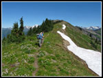
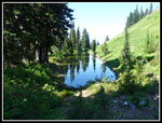
The route soon began to climb again. The hillside became very steep and being on the minimal trail was much easier than trying to side hill across here. Still on pretty good tread I was questioning the lack of a trail between Longfellow and Bryant. All seemed to be going well. The flower show continued most all the way along. All too soon the trail disappeared. We found animal trails that seemed to be it then they would go away. We looked higher and lower and finally chose to just traverse ahead. The slope was now not all that steep. Plodding along we came to a landmark I had read about. A long skinny tarn sits on a rare flat spot. It is pretty stagnant and I would only pump water from it in an emergency. A little before the tarn we were back on the trail. At the tarn the trail disappeared once again.
We looked all over and found no trace of a trail or even a boot print. Well, what to do? We chose to just continue on a level traverse. The hope was that this would take us all the way around Bryant and allow us to pick up the real trail coming from Kodak Peak. That was the thinking. All was good until the slope began to get much steeper. We could see ahead that there was a pretty deep gully we would have to cross. On the other side the slope looked even steeper and the map confirmed it. Now what to do? We might be able to go lower but that did not look promising. The only other option was to get above the gully and maybe climb all the way to the ridge top. Up it was. I went ahead as we slogged straight up the slope. It looked pretty steep higher up. We sure did not want to abandon the weekend so higher we went.
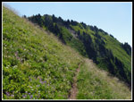
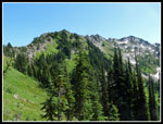
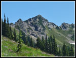
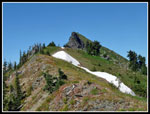
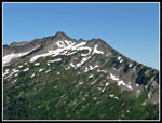
Not too much higher I ran into a trail. In fact it was 'the" trail. Only a single boot wide but a heck of a lot better than nothing. It traversed steeply over to the gully and above it. More of a scramble than tread it did allow us to make good progress. Just as I was confident this would lead us up to the ridge top it just ended. Huh? A perfectly good trail and then nothing. The only alternative was to head straight up again. A little scrambling and there it was once again. Now we were set for a short climb to the ridge top. I naively hoped we were beyond Bryant Peak but it was not to be. The rocky spire was just ahead of us. Great views from the ridge. Scrambling the right (east) side did not look like any fun. The trail dropped off the crest onto the right side and continued all the way to the base of the summit block.
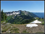
A little to my surprise the route dropped off on the left (west) side of the ridge. The only question left is was this the high route or a climbers trail to the summit? We could now see the ridge heading over to Kodak Peak and the PCT. We just had to traverse a very very steep slope. Not many folks have been up here any time lately. We seldom saw any boot prints. The trail was very narrow and in places it was just huckleberry roots and branches for footing. Not confidence inspiring. We chose to head on hoping the tread would improve. In fact it did. Our downward traverse saw the tread get better as the dangerous slope eased. Soon the going was no problem at all. We cut around a point on the ridge and met the ridge at a lower elevation and crossed to the north side.
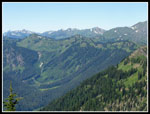
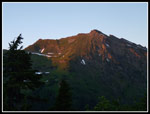
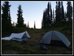
From here on the going was much easier. We soon found a well defined trail that was mostly just north of the ridge crest. Lots more meadows along this stretch. Many more wildflower photos to take. The route goes right over one flower encrusted high point. We could look back on much of our route. Since the ridge curves Bryant did not block our views. Approaching the PCT, the trail had crossed back to the south side of the ridge with views of Meander Meadow. It had been a long day when we reached the Pacific Crest Trail. We dropped back down a short way to a place where all three tents would fit. Gary and I hiked north on the PCT a short way to find water we brought back to camp. After dinner we were more than ready to head to bed. While hiking the bugs were not bad but at rest they were voracious. I wore a rain jacket and rain pants with a head net around camp.
Now for some thought on the route. It is not a trail you follow from end to end. It definitely requires some route finding. It is generally narrow and really narrow in spots. The hillside is not that bad most of the way but very steep in a few places. My balance is not great with an overnight pack but I had no problems. There are a few keys. Approaching Longfellow Peak if the lower trail goes through you are golden. If you go higher as we did you will come to a wide sloped rocky basin. The trail is 150' or so lower. Drop down and look for it. If you find the tarn begin a gentle upward traverse. Near the gully go up or down until you find the trail. It is much easier than just climbing up the slope. Lastly, the route continues north right on or just right of the ridge up to the south end of the Bryant summit before diving over the ridge on the Meander Meadow (west) side and dropping down to the ridge north of Bryant. Bryant did not look all that hard to climb from the north. In summary, it is a challenging traverse for experienced hikers but very reasonable. I would not recommend trail hikers go expecting to follow a route from end to end. Per my GPS I traveled 11.6 miles with 5850' of gain. That includes my early error. Now, on to day 2.
Click on thumbnails to get
larger pictures.
Day 2
Trips - 2011
Home
Day 1
I met Gary and John in Bothell and we headed east on Highway 2. At Coles Corner we turned towards Lake Wenatchee. The road rounds the lake and heads back west. At the road end is the Wenatchee Ford trailhead. Half the trailhead area is marked "no parking" leaving only eight official spaces for a very popular trailhead. It is more popular now that the Suiattle, Whitechuck, and NF Sauk roads on the west side of the crest are closed. We were early enough to snag a spot. By 9:05 we were on the trail. 3/8th of a mile and 200' feet higher I realized I had left my camera in the car. I was rewarded with a dash back and an extra 3/4 miles and 200' of gain for the trip. After that faux pas it was time to get down to a short steep ascent of Poe Mountain.
Not knowing if we would find any water along the ridge we brought plenty. That pushed my pack weight up to about 29 lbs. Also, we were not sure if the route traversed the east side of the ridge at any point so we brought ice axes. They were never used. There was almost no semi current information on the area. The trail is well graded and we made good time. The cool morning air helped. It was only 41 degrees when we started. It felt a whole lot warmer high on Poe Mountain. Poe Mountain is 3000' up in only three miles of trail. We followed the trail to where is seemed to disappear in a small meadow just below the ridge. A faint trail had two rocks across it. We knew the Poet Ridge route would be on top of the ridge so we headed straight up. Indeed a narrow boot path was found. We turned right and soon met the real trail coming up from the meadow.
We dropped packs and did the last short climb without the weight. Great views from the old lookout site on the summit. Three miles down. We could see much of the remaining 7 miles to the junction with the PCT below Kodak Peak. Add one more lookout site to the many I have already visited. We soon dropped to our packs and started out on the Poet Ridge "trail". The route goes by Longfellow and Bryant Peaks and a side ridge goes to Whittier Peak. That one was not in the plan. My GPS map showed the route going right along the ridge top. John's paper map showed it all over the ridge. Neither proved to be very accurate. The first part was indeed on the ridge crest but we soon dropped to the west side and stayed there most of the way.
The flower show began immediately and never let up for the whole three days. Some were a little past prime but the bulk of the wildflowers were right near their peak. The meadows constituted the whole sides of the ridge. They went on and on and on. I have seen more intense colors and denseness but for sheer volume of wildflowers I doubt I have ever done a hike to match this one. The tread was easy to follow though narrow much of the way. With the steep slope you did not want to slip and fall. With moderate care the trail was fine.
As we neared Longfellow Peak we came to a junction. A level traverse ahead or a slightly more used trail switchbacking higher. We chose to go up. The route leveled then began to descend underneath the peak. We found some snow fields here. Not hazardous just fun to boot ski down. Much to my surprise we met a group here. They were hunters out scouting for the coming season. They had been here before but not much further. They did point out we needed to descend to pick up the trail again. The trail petered out. We had lunch and then began to drop. We found a track on heather that led down to the trail. At a "T" we turned right. I'm not sure if the other trail is the one we had left earlier. If so, then just staying level would have been quicker and easier than climbing and descending.
The route soon began to climb again. The hillside became very steep and being on the minimal trail was much easier than trying to side hill across here. Still on pretty good tread I was questioning the lack of a trail between Longfellow and Bryant. All seemed to be going well. The flower show continued most all the way along. All too soon the trail disappeared. We found animal trails that seemed to be it then they would go away. We looked higher and lower and finally chose to just traverse ahead. The slope was now not all that steep. Plodding along we came to a landmark I had read about. A long skinny tarn sits on a rare flat spot. It is pretty stagnant and I would only pump water from it in an emergency. A little before the tarn we were back on the trail. At the tarn the trail disappeared once again.
We looked all over and found no trace of a trail or even a boot print. Well, what to do? We chose to just continue on a level traverse. The hope was that this would take us all the way around Bryant and allow us to pick up the real trail coming from Kodak Peak. That was the thinking. All was good until the slope began to get much steeper. We could see ahead that there was a pretty deep gully we would have to cross. On the other side the slope looked even steeper and the map confirmed it. Now what to do? We might be able to go lower but that did not look promising. The only other option was to get above the gully and maybe climb all the way to the ridge top. Up it was. I went ahead as we slogged straight up the slope. It looked pretty steep higher up. We sure did not want to abandon the weekend so higher we went.
Not too much higher I ran into a trail. In fact it was 'the" trail. Only a single boot wide but a heck of a lot better than nothing. It traversed steeply over to the gully and above it. More of a scramble than tread it did allow us to make good progress. Just as I was confident this would lead us up to the ridge top it just ended. Huh? A perfectly good trail and then nothing. The only alternative was to head straight up again. A little scrambling and there it was once again. Now we were set for a short climb to the ridge top. I naively hoped we were beyond Bryant Peak but it was not to be. The rocky spire was just ahead of us. Great views from the ridge. Scrambling the right (east) side did not look like any fun. The trail dropped off the crest onto the right side and continued all the way to the base of the summit block.
A little to my surprise the route dropped off on the left (west) side of the ridge. The only question left is was this the high route or a climbers trail to the summit? We could now see the ridge heading over to Kodak Peak and the PCT. We just had to traverse a very very steep slope. Not many folks have been up here any time lately. We seldom saw any boot prints. The trail was very narrow and in places it was just huckleberry roots and branches for footing. Not confidence inspiring. We chose to head on hoping the tread would improve. In fact it did. Our downward traverse saw the tread get better as the dangerous slope eased. Soon the going was no problem at all. We cut around a point on the ridge and met the ridge at a lower elevation and crossed to the north side.
From here on the going was much easier. We soon found a well defined trail that was mostly just north of the ridge crest. Lots more meadows along this stretch. Many more wildflower photos to take. The route goes right over one flower encrusted high point. We could look back on much of our route. Since the ridge curves Bryant did not block our views. Approaching the PCT, the trail had crossed back to the south side of the ridge with views of Meander Meadow. It had been a long day when we reached the Pacific Crest Trail. We dropped back down a short way to a place where all three tents would fit. Gary and I hiked north on the PCT a short way to find water we brought back to camp. After dinner we were more than ready to head to bed. While hiking the bugs were not bad but at rest they were voracious. I wore a rain jacket and rain pants with a head net around camp.
Now for some thought on the route. It is not a trail you follow from end to end. It definitely requires some route finding. It is generally narrow and really narrow in spots. The hillside is not that bad most of the way but very steep in a few places. My balance is not great with an overnight pack but I had no problems. There are a few keys. Approaching Longfellow Peak if the lower trail goes through you are golden. If you go higher as we did you will come to a wide sloped rocky basin. The trail is 150' or so lower. Drop down and look for it. If you find the tarn begin a gentle upward traverse. Near the gully go up or down until you find the trail. It is much easier than just climbing up the slope. Lastly, the route continues north right on or just right of the ridge up to the south end of the Bryant summit before diving over the ridge on the Meander Meadow (west) side and dropping down to the ridge north of Bryant. Bryant did not look all that hard to climb from the north. In summary, it is a challenging traverse for experienced hikers but very reasonable. I would not recommend trail hikers go expecting to follow a route from end to end. Per my GPS I traveled 11.6 miles with 5850' of gain. That includes my early error. Now, on to day 2.
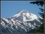
 Mt. Daniel |
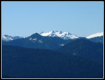
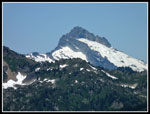
 Glacier Peak |
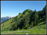 Meadowy Slopes |
 John & Wildflowers |
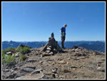 Gary On Poe Summit |
 Sloan Peak |
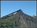 Whittier Peak |
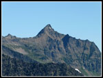 Mt. David |
 Ridge Heading North |
 Flowers Improve |
 Flowers & Whittier |
 Gary & John On Ridge |
 Sunshine & Lupine |
 Narrow Ribbon Of Trail |
 Bryant To The North |
 Meander Meadow |
 Nearing Rocky Basin |
 Basin Is Now Behind |
 Green Meadows |
 More Flowers |
 Hiking Through Meadows |
 Longfellow Peak |
 Reflection In Tarn |
 White & Yellow |
 Bump On The Ridge |
 Indian Head In Sight |
 Steeper & Narrow Tread |
 Straight Uphill |
 Sketchy Trail |
 On The Ridge Top |
 Bryant Peak Just Ahead |
 Longfellow Behind Us |
 View To Whittier |
 Ridge To The North |
 Meadow Under Bryant |
 Beautiful Asters |
 Lupine & Pearly Everlasting |
 Bryant Behind Us |
 Flowers Atop Bump |
 Poet Ridge |
 Alpenglow |
 Sunset At Camp |
Day 2
Trips - 2011
Home