9/01-04/12
Gary
and I did this loop in three
days back in 2003. It was very hot at the end of July but the flowers
and views were spectacular. Nine years later we planned a return with a
fourth day for more exploration. John joined us for this trip.
Day 1
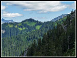
We planned to leave Saturday and come back on Tuesday, a day after the end of the Labor Day weekend. We met in North Seattle at 6:10 am and headed for Granite Falls and the Mountain Loop Highway. Up to Barlow Pass then north to the North Fork Sauk Road. Even though it was only 8:05 am when we reached the 2150' trailhead, the lot was nearly full. We slipped into a last spot. There were half a dozen more cars out on the main road. By 8:15 am we were on our way. The turn off for the Red Mountain trail is just a minute up the route. Lots of big skunk cabbage leaves in the early part. The NF Sauk trail is often heard but seldom seen. The route is just out of sight most of the way up the valley. Lots of big trees. The trees make this a good day hike as well as the gateway to Glacier Peak. About the only gateway on the west side with the Whitechuck Trail gone and the Suiattle Road washed out and closed for now.
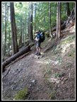
The trail is in excellent shape. Logged out and brushed all the way to the PCT. We expected sunshine but clouds began as we headed into the mountains and it was cloudy much of the first day. We did the loop counter clockwise to take advantage of the north facing forested slope for most of the elevation gain. At about two miles along the trail we reached the junction with the trail up Pilot Ridge. It is just a short distance to the river. On our first visit to Pilot Ridge we had to ford the river. In 2003 there was a big log to cross on. This time we came out at a log crossing. It was a little narrow for my comfort and high off the water. Probably fine for most folks. A little farther up river was a bigger log. Part way over I had to get over another log laying on the first. Still, it was easier for me. Gary and John followed me over.
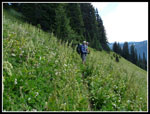
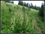
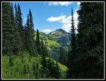
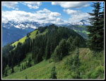
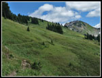
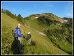
The Pilot Ridge Trail wastes no time gaining elevation. It is not an overly steep trail but it climbs relentlessly. This trail is less popular than the NF Sauk and it receives less maintenance. There are a few logs over the trail but none posed a problem. The early start, deep forest, and clouds made for a cool ascent. There is a creek at 3600' that provided enough water for us to pump. Gary noted it on our earlier trips and it allowed us to carry less water weight up the trail. It is about 3 miles from the river to the 5000' crest of Pilot Ridge gaining 2600'. The climbing is far from over. The trail climbs on the crest and in meadows on the right side.
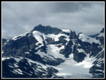
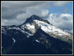
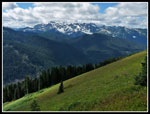
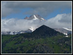
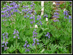
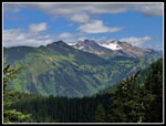
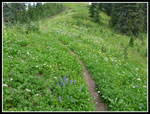
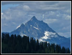
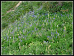
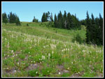
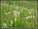
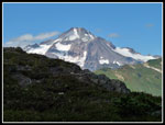
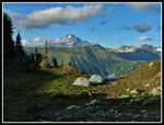
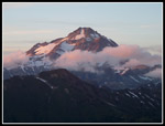
We soon had views out to Sloan Peak though the top was in the clouds. Many flowers are done on this southwest slope though there is still much color. Western anemone were flopping there fuzzy heads here as well as on much of our route. Some lupine still blooming but very little Indian paintbrush. At a flat viewpoint we met the first person of the day. Riptide on NWHikers.net was completing the loop in the opposite direction. There are a number of ups and downs on the ridge adding to the overall gain. In spots we had views to the north as well as the south. Glacier Peak went in and out of the clouds. When Johnson Mountain came into view we knew we were getting close to our camp spot. Rather than joining the crowds at Blue Lake we chose to camp near the summit of the ridge again. The GPS helped show where to leave the trail and climb to the saddle above.
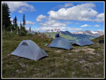
There was still water in a tarn on the south side of the ridge, much to my surprise. We had a big snow year but I did not expect it to be this wet so late in the year. We crossed the crest and dropped to the bench where we set up camp. The tarn there was full and a small snowbank will feed it through the fall. We had a cool breeze most of the day which was refreshing on the climb. It was not as much appreciated in camp. At 6000' it was a very cold steady wind. Our three Shires tarptents are not at there best in a steady cold wind.
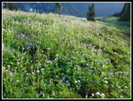
We took care of food hanging, filled water bags, and lazed around until dinner time. Finding a place to cook was hard. We checked all around and the wind blew everywhere. I finally found a spot that was calm and about 10' wide behind a rock. That was the kitchen. After dinner we chose to repeat a favorite part of the 2003 trip. We took now much lighter packs and headed to Johnson Mountain for sunset. Once over the ridge crest the wind died. Too late now to move camp so we continued on. The hillside was covered in anemone. Quite a sight. We dropped to the trail and followed it towards Johnson. The trail here is narrow and sloughing in places. It is too far in and too dry to get much maintenance. Not a good place to put a backcountry team. We passed one hiker sitting on a rock enjoying the late day sun. Johnson was a full two mile hike and we had to speed up to reach the top by sunset.
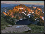
Sunset was at 7:47 pm and we topped out on the 6721' summit with just a few minutes to spare. The color was pretty good though short lived. The upper section of the old lookout trail is narrow and rocky. We wanted to get down before dark. Our summit stay was short. The upper slopes of the mountain had very good color including paintbrush of which we had seen very little. Blue Lake was right below us. We made it half way back in fading light. Somewhat farther in near dark. Finally we turned on our headlamps for the last bit. Once again we went from calm to strong winds as we crossed the saddle to our campsite.
The tents were already wet with dew at 8:50 pm. I did my best to close up my tarptent from the wind and the result was much condensation. I thought the wind would minimize it. It did not. A near full moon lit the night and the wind howled. I did not sleep well. For the day we hiked about 13.5 miles and gained 5700', 4500' with four day full backpacks.
Click on thumbnails to get
larger pictures.
Day 2
Trips - 2012
Home
Day 1
We planned to leave Saturday and come back on Tuesday, a day after the end of the Labor Day weekend. We met in North Seattle at 6:10 am and headed for Granite Falls and the Mountain Loop Highway. Up to Barlow Pass then north to the North Fork Sauk Road. Even though it was only 8:05 am when we reached the 2150' trailhead, the lot was nearly full. We slipped into a last spot. There were half a dozen more cars out on the main road. By 8:15 am we were on our way. The turn off for the Red Mountain trail is just a minute up the route. Lots of big skunk cabbage leaves in the early part. The NF Sauk trail is often heard but seldom seen. The route is just out of sight most of the way up the valley. Lots of big trees. The trees make this a good day hike as well as the gateway to Glacier Peak. About the only gateway on the west side with the Whitechuck Trail gone and the Suiattle Road washed out and closed for now.
The trail is in excellent shape. Logged out and brushed all the way to the PCT. We expected sunshine but clouds began as we headed into the mountains and it was cloudy much of the first day. We did the loop counter clockwise to take advantage of the north facing forested slope for most of the elevation gain. At about two miles along the trail we reached the junction with the trail up Pilot Ridge. It is just a short distance to the river. On our first visit to Pilot Ridge we had to ford the river. In 2003 there was a big log to cross on. This time we came out at a log crossing. It was a little narrow for my comfort and high off the water. Probably fine for most folks. A little farther up river was a bigger log. Part way over I had to get over another log laying on the first. Still, it was easier for me. Gary and John followed me over.
The Pilot Ridge Trail wastes no time gaining elevation. It is not an overly steep trail but it climbs relentlessly. This trail is less popular than the NF Sauk and it receives less maintenance. There are a few logs over the trail but none posed a problem. The early start, deep forest, and clouds made for a cool ascent. There is a creek at 3600' that provided enough water for us to pump. Gary noted it on our earlier trips and it allowed us to carry less water weight up the trail. It is about 3 miles from the river to the 5000' crest of Pilot Ridge gaining 2600'. The climbing is far from over. The trail climbs on the crest and in meadows on the right side.
We soon had views out to Sloan Peak though the top was in the clouds. Many flowers are done on this southwest slope though there is still much color. Western anemone were flopping there fuzzy heads here as well as on much of our route. Some lupine still blooming but very little Indian paintbrush. At a flat viewpoint we met the first person of the day. Riptide on NWHikers.net was completing the loop in the opposite direction. There are a number of ups and downs on the ridge adding to the overall gain. In spots we had views to the north as well as the south. Glacier Peak went in and out of the clouds. When Johnson Mountain came into view we knew we were getting close to our camp spot. Rather than joining the crowds at Blue Lake we chose to camp near the summit of the ridge again. The GPS helped show where to leave the trail and climb to the saddle above.
There was still water in a tarn on the south side of the ridge, much to my surprise. We had a big snow year but I did not expect it to be this wet so late in the year. We crossed the crest and dropped to the bench where we set up camp. The tarn there was full and a small snowbank will feed it through the fall. We had a cool breeze most of the day which was refreshing on the climb. It was not as much appreciated in camp. At 6000' it was a very cold steady wind. Our three Shires tarptents are not at there best in a steady cold wind.
We took care of food hanging, filled water bags, and lazed around until dinner time. Finding a place to cook was hard. We checked all around and the wind blew everywhere. I finally found a spot that was calm and about 10' wide behind a rock. That was the kitchen. After dinner we chose to repeat a favorite part of the 2003 trip. We took now much lighter packs and headed to Johnson Mountain for sunset. Once over the ridge crest the wind died. Too late now to move camp so we continued on. The hillside was covered in anemone. Quite a sight. We dropped to the trail and followed it towards Johnson. The trail here is narrow and sloughing in places. It is too far in and too dry to get much maintenance. Not a good place to put a backcountry team. We passed one hiker sitting on a rock enjoying the late day sun. Johnson was a full two mile hike and we had to speed up to reach the top by sunset.
Sunset was at 7:47 pm and we topped out on the 6721' summit with just a few minutes to spare. The color was pretty good though short lived. The upper section of the old lookout trail is narrow and rocky. We wanted to get down before dark. Our summit stay was short. The upper slopes of the mountain had very good color including paintbrush of which we had seen very little. Blue Lake was right below us. We made it half way back in fading light. Somewhat farther in near dark. Finally we turned on our headlamps for the last bit. Once again we went from calm to strong winds as we crossed the saddle to our campsite.
The tents were already wet with dew at 8:50 pm. I did my best to close up my tarptent from the wind and the result was much condensation. I thought the wind would minimize it. It did not. A near full moon lit the night and the wind howled. I did not sleep well. For the day we hiked about 13.5 miles and gained 5700', 4500' with four day full backpacks.
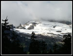 Cloudy Sloan Peak |
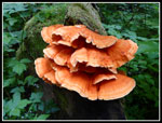 Very Orange Fungus |
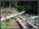 First Crossing Log |
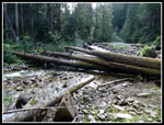 Logs We Crossed On |
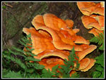 Brighter Orange |
 On Pilot Ridge Trail |
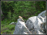 Pika |
 Ridge Top |
 Kyes Peak |
 Sloan Peak |
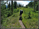
 Trail In Meadows |
 Monte Cristo Peaks |
 Cloudy Glacier Peak |
 Meadowed Ridge |
 Flowering Corn Lily |
 Lupine |
 White Mountain |
 Johnson Mt. In Gap |
 Trail Through Flowers |
 Bedal Peak |
 Lupine & Lousewort |
 Pilot Ridge Behind Us |
 About To Leave Trail |
 Anemone Field |
 Anemone Close Up |
 Pilot Ridge Camp |
 Cloudless Glacier Peak |
 View Of Camp |
 On Our Way To Johnson |
 Flower Field |
 Blue Lake Alpenglow |
 Glow On Glacier |
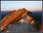 Johnson Summit |
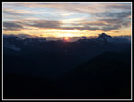 Setting Sun |
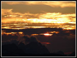 Better Color |
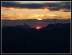 Bright Red Point |
Day 2
Trips - 2012
Home