1-08-12
Janet
wanted to head east for a
snow scramble. Tom was also on board. Count me in. I was in on a winter
scramble of Red Top in 2008
from the Teanaway side. In April
of 2011
Our group summited from Mineral Springs on Highway 97, also on snow.
Now I was back for a third try. We knew the snow cover was thin but
there were no trip reports on this area. We brought snowshoes, ice
axes, and microspikes. That covered most possibilities. We met in
Bellevue at 6:20 am. Way before daylight. Up and over Snoqualmie Pass
then north on Highways 970 and 97. We parked at the far south end of
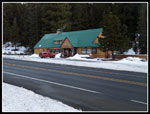
the lot at Mineral Springs Resort, far from their customer parking. At
8:10 am we crossed the highway and entered the snow covered campground.
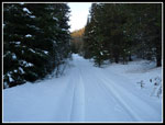
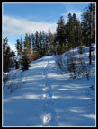
We had to check the map and GPS a time or two but had little trouble finding the road up Medicine Creek. Someone had driven a truck up the road recently and the tracks were 6+ inches deep. A little slick but easy walking with no sinking in. It was all blue sky above but near freezing temperatures. Once out of the valley it warmed up quickly. At 1.4 miles from the Highway and 1.1 miles from the start of the creekside road we reached the junction. A lesser road went straight ahead. The main road turned to the left. We went right between them and began to ascend the nose of the ridge.
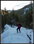
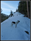
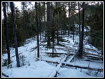
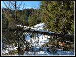
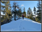
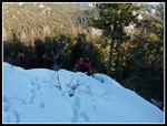
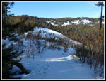
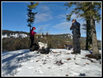
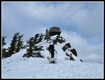
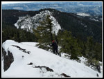
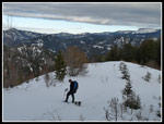
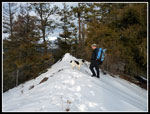
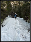
In the trees was very thin and icy snow. Janet went with microspikes while Tom and I just went with boots. Jasper the dog used his all paw drive and had the best results. The ridge is a series of ups and downs with a lot more ups. At no point is it "knife edged" or exposed. A few of the ups and downs are very steep. Underbrush is a minor problem. Mostly the forest is pretty open. Downed trees are more of a problem. More so with such thin snow cover. Stepping into a void and falling to the ground was a concern. We managed fine in both directions.
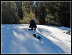
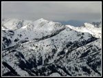
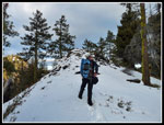
As we ascended there were a few openings with views out. It was much warmer now and when in a little sunshine it was almost balmy for January. After a particularly steep short climb the ridge makes a final descent. The ridge drops down to an old logging road. Last year we dropped down the right side of the ridge on a steep grassy slope. With an inch of snow on it it looked a bit slick. We went right down the nose of the ridge on dirt and rocks with a few inches of snow. marginally better. There was enough snow to glissade the last 15 feet down the cut bank to the road.
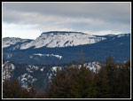
A right turn brought us to a big old clear cut with views northwest to northeast. The summit was in sight and it looked to be a long way away. The snow was deeper in the open but we continued with just boots. Shortly the road turned to the right and narrowed. I seemed to recall going left of center up the slope here. There were two ruts in the snow like tire ruts. After a little map viewing we took this route. The track followed a ridge uphill, steeply at times. Tom noticed yellow diamonds along here. Perhaps on old ski route? At the high point we stopped for a food and water break. Better views of the summit now. It was looking a little closer.
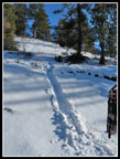
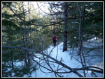
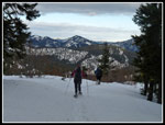
The route dropped a bit to another old road with clear cut opened views to the right (north). Immediately the snow was much deeper. Deep enough for us to put on snowshoes. Still not a whole lot of snow but snowshoes beat sinking in a foot with each step. This road soon led to a junction with a road perpendicular to ours. We consulted the map and considered going right a bit but chose instead to head straight across and but into the forest. Some of this section was great in open forest. Some of it was in young densely packed trees that required something less than a straight line to get through. Soft and thin enough snow to have a few snowshoe post holes too.
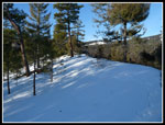
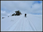
We popped out of the forest onto the main road that goes from Mineral Springs on Highway 97 up and over the ridge and down to the NF Teanaway Road. A nice job of leading by Tom as he brought us out within 75' of the last switchback in the road before it reaches the ridge top. We turned left, uphill, and now had a groomed snowmobile road most of the rest of the way. My GPS showed 3.50 miles to that point. That meant the whole ridge scramble was only 2.1 miles. It seemed like more. The road is very gently graded and made for easy walking. After nearly a mile we saw the sign stating we had one more mile to Red Top.
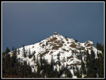
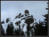
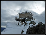
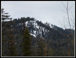
Once on the ridge top the road has a few ups and downs but not steep ones. After the junction with the route to the Teanaway we heard some snowmobiles. They did not go our way. At the summer parking lot we saw a group of snowmobilers who were having a good time. The last half mile we also noticed the clouds rapidly coming in. Our time in the sunshine seemed to be going away. Last April the last steep climb to the top was interesting as the snow was very consolidated and icy. This time the conditions were much easier. We followed a snowmobile track to just below the lookout building. Snowmobiles were still there. They left as we approached.
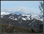
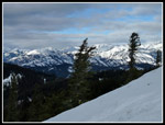
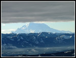
At the lookout the wind was blowing and it was very cold. much different than just a few hundred feet below. Tom headed over to the small utility building and we followed. On the lee side it was windless and actually pretty comfortable. It was 12:30 pm. Mt. Stuart was now in the clouds but most of the lower peaks were in the clear. The upper half of Mt. Rainier was covered too. Not a bad place to sit down for lunch. One of these days I'll have to visit in the summer when the lookout is manned by volunteers and see the inside. Still, it is a little more spectacular in the winter. At 1:00 pm we packed up and headed down. As we dropped we could see that it was clear over Mt. Rainier. At a lower elevation we could now see the whole mountain with a dark closer cloud layer providing the appearance of a black band over the peak. It made for some interesting photos.
With a little more than 3 1/2 hours of daylight we were confident we would be down before dark. Our trip down was almost exactly the same as the route up. As usual the snowshoes stayed on longer coming down than up. The snow was noticeably softer. When we reached the spot where we first exited the ridge down the nose we chose to climb up the side to attain the ridge once again. It was steep on thin snow but our snowshoe crampons provided enough grip. Back on the ridge the snowshoes were backed away for the rest of the trip. We also took a wrong turn back at the campgrounds. Our new route was all road and a little shorted than our cross country route coming in. We reached the car at 4:15 pm, well before dark.
The starting elevation is at about 2700'. The summit is at 5361' That makes 2660' of net gain. My GPS recorded 11 miles RT with 3300' of gain. That leaves about 700' of ups and downs RT. That seems about right to me. This is a really fun snow scramble. With more snow the downed logs on the ridge would be buried. It would require a lot more snowshoeing though. The route can be challenging depending on snow conditions and there is some route finding along the way but this is a nice shortcut vs. the long road to the summit. Other than snowmobiles on the upper road section you are almost guaranteed not to see anyone else. A really fun trip with a good group. However, after two winters in a row I'll probably not be back for awhile.
Click on thumbnails to get
larger pictures.
Trips - 2012
Home
We had to check the map and GPS a time or two but had little trouble finding the road up Medicine Creek. Someone had driven a truck up the road recently and the tracks were 6+ inches deep. A little slick but easy walking with no sinking in. It was all blue sky above but near freezing temperatures. Once out of the valley it warmed up quickly. At 1.4 miles from the Highway and 1.1 miles from the start of the creekside road we reached the junction. A lesser road went straight ahead. The main road turned to the left. We went right between them and began to ascend the nose of the ridge.
In the trees was very thin and icy snow. Janet went with microspikes while Tom and I just went with boots. Jasper the dog used his all paw drive and had the best results. The ridge is a series of ups and downs with a lot more ups. At no point is it "knife edged" or exposed. A few of the ups and downs are very steep. Underbrush is a minor problem. Mostly the forest is pretty open. Downed trees are more of a problem. More so with such thin snow cover. Stepping into a void and falling to the ground was a concern. We managed fine in both directions.
As we ascended there were a few openings with views out. It was much warmer now and when in a little sunshine it was almost balmy for January. After a particularly steep short climb the ridge makes a final descent. The ridge drops down to an old logging road. Last year we dropped down the right side of the ridge on a steep grassy slope. With an inch of snow on it it looked a bit slick. We went right down the nose of the ridge on dirt and rocks with a few inches of snow. marginally better. There was enough snow to glissade the last 15 feet down the cut bank to the road.
A right turn brought us to a big old clear cut with views northwest to northeast. The summit was in sight and it looked to be a long way away. The snow was deeper in the open but we continued with just boots. Shortly the road turned to the right and narrowed. I seemed to recall going left of center up the slope here. There were two ruts in the snow like tire ruts. After a little map viewing we took this route. The track followed a ridge uphill, steeply at times. Tom noticed yellow diamonds along here. Perhaps on old ski route? At the high point we stopped for a food and water break. Better views of the summit now. It was looking a little closer.
The route dropped a bit to another old road with clear cut opened views to the right (north). Immediately the snow was much deeper. Deep enough for us to put on snowshoes. Still not a whole lot of snow but snowshoes beat sinking in a foot with each step. This road soon led to a junction with a road perpendicular to ours. We consulted the map and considered going right a bit but chose instead to head straight across and but into the forest. Some of this section was great in open forest. Some of it was in young densely packed trees that required something less than a straight line to get through. Soft and thin enough snow to have a few snowshoe post holes too.
We popped out of the forest onto the main road that goes from Mineral Springs on Highway 97 up and over the ridge and down to the NF Teanaway Road. A nice job of leading by Tom as he brought us out within 75' of the last switchback in the road before it reaches the ridge top. We turned left, uphill, and now had a groomed snowmobile road most of the rest of the way. My GPS showed 3.50 miles to that point. That meant the whole ridge scramble was only 2.1 miles. It seemed like more. The road is very gently graded and made for easy walking. After nearly a mile we saw the sign stating we had one more mile to Red Top.
Once on the ridge top the road has a few ups and downs but not steep ones. After the junction with the route to the Teanaway we heard some snowmobiles. They did not go our way. At the summer parking lot we saw a group of snowmobilers who were having a good time. The last half mile we also noticed the clouds rapidly coming in. Our time in the sunshine seemed to be going away. Last April the last steep climb to the top was interesting as the snow was very consolidated and icy. This time the conditions were much easier. We followed a snowmobile track to just below the lookout building. Snowmobiles were still there. They left as we approached.
At the lookout the wind was blowing and it was very cold. much different than just a few hundred feet below. Tom headed over to the small utility building and we followed. On the lee side it was windless and actually pretty comfortable. It was 12:30 pm. Mt. Stuart was now in the clouds but most of the lower peaks were in the clear. The upper half of Mt. Rainier was covered too. Not a bad place to sit down for lunch. One of these days I'll have to visit in the summer when the lookout is manned by volunteers and see the inside. Still, it is a little more spectacular in the winter. At 1:00 pm we packed up and headed down. As we dropped we could see that it was clear over Mt. Rainier. At a lower elevation we could now see the whole mountain with a dark closer cloud layer providing the appearance of a black band over the peak. It made for some interesting photos.
With a little more than 3 1/2 hours of daylight we were confident we would be down before dark. Our trip down was almost exactly the same as the route up. As usual the snowshoes stayed on longer coming down than up. The snow was noticeably softer. When we reached the spot where we first exited the ridge down the nose we chose to climb up the side to attain the ridge once again. It was steep on thin snow but our snowshoe crampons provided enough grip. Back on the ridge the snowshoes were backed away for the rest of the trip. We also took a wrong turn back at the campgrounds. Our new route was all road and a little shorted than our cross country route coming in. We reached the car at 4:15 pm, well before dark.
The starting elevation is at about 2700'. The summit is at 5361' That makes 2660' of net gain. My GPS recorded 11 miles RT with 3300' of gain. That leaves about 700' of ups and downs RT. That seems about right to me. This is a really fun snow scramble. With more snow the downed logs on the ridge would be buried. It would require a lot more snowshoeing though. The route can be challenging depending on snow conditions and there is some route finding along the way but this is a nice shortcut vs. the long road to the summit. Other than snowmobiles on the upper road section you are almost guaranteed not to see anyone else. A really fun trip with a good group. However, after two winters in a row I'll probably not be back for awhile.
 Mineral Springs |
 Medicine Creek Road |
 Janet On Ridge |
 Jasper Leads |
 View Of Lookout |
 Downed Trees |
 Time To Duck |
 Open Ridge |
 Hiking Ridge Top |
 Tom & Jasper |
 Steepest Spot |
 View To The North |
 Another Lookout View |
 More Views |
 Slide To Road |
 Target Ridge Is Ahead |
 Food Break |
 Snowshoes Are On |
 Northeast Views |
 Now In Forest |
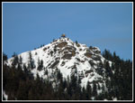
 Lookout From Trailhead |
 Last Steep Climb |
 T & J Below Lookout |
 Sun & Shade On Peaks |
 Lookout From Lunch Spot |
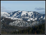
 Teanaway Peaks |
 Janet Descending |
 Mt. Rainier & Clouds |
 Back In The Open |
 Break Time |
 Diamond Head |
 Last Lookout View |
 A Boy & His Dog |
 Descending Ridge |
 Lower On Ridge |
Trips - 2012
Home