7-01-12
I
last hiked to Elbow Peak in 1990. since then I have done several snow
scrambles of Yellow Hill. Gwen mentioned Elbow and I joined in along
with Janet. The east side looked better with only a 20% chance of rain.
It was raining at my house, at our meeting in Bellevue and most of the
way up to Snoqualmie Pass. At Easton, as often happens, some blue sky
began to show itself. Janet and I did Yellow
Hill a year ago in April and it
was mostly on snow. This time there was only a few patches all the way
to Elbow Peak. We Drove up the Teanaway Valley turning off for the West
then Middle Fork Roads. The dirt part of the road was potholed but
fine. One worse spot where the road slumped last year but fine in the
Subaru and most cars would be okay.
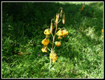
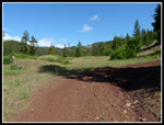
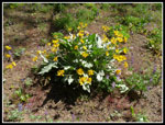
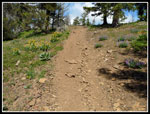
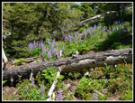
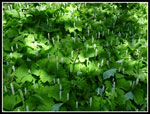
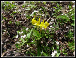
We were packed and on our way at 9:35 am. The trailhead elevation is about 2850'. The trail goes around the tank traps blocking the road/trail. The first 1.6 miles in on road. There are a few shortcuts where a steep trail joins switchbacks. We stuck to the road up and down. We found a big patch of tiger lilies right at the start. The flower show never let up. It was a very good wildflower show. I sure was not expecting it. Having only hiked this trail in September and on snow I had no idea. The trail is one of the few in the Teanaway Valleys that allows motorcycles. This keeps some people away. It should not. On my first trip I saw one motorcycle. This time we saw none.
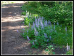
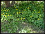
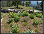
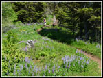
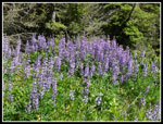
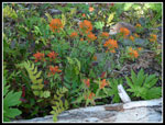
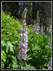
The tiger lilies gave way to Indian paintbrush and salsify and lupine. Lots and lots of lupine. In places the entire hillside above and below the road and later the trail was covered in blooming lupine. More than I have ever seen outside of the high mountain meadows. Far more than I have seen anywhere else this year. The spot forecast for 4000' was for a high near 60 degrees. It was much warmer than that. We were feeling the sun and heat at 10:00 am. Fortunately after the road section much of the way is in forest. Higher up there was a cooling wind. At the road end we headed steeply up the trail. This old trail is not gentle. There are a few switchbacks but for the most part it is straight up the hill.
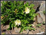
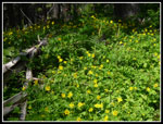
At the ridge top, about 2.2 miles in, we stopped for a break. Gwen pointed out a find from an earlier trip, a few Tweedy's lewisia in bloom. Some very colorful penstemon too. The balsamroot was finishing down low but higher up it was still blooming. Add in some big patches of arnica for the yellows. Some phlox in various places too. The route has several ups and downs as it follows the ridge. Uphills late in the day coming out are always appreciated. In some deeper forest we had fading trillium, false Solomon's seal, and vanilla leaf. From desert to forest flowers in just a few minutes. After 22 years I had little recollection of the trail. On snow you just go straight up.
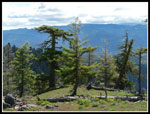
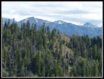
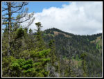
There was one spring high on the ridge as a pretty good small creek was running down the trail for a short distance. That was the only water of the day. It is a dry hike. As the trail began to contour around the east and north sides of Yellow Hill it became steeper. On open slopes we saw more paintbrush and blooming glacier lilies. The snow has not been gone long. The trail contours close to the top of Yellow Hill before dropping on the way to Elbow Peak. We hit snow about 60' below the top and chose to just go cross country to the top. There is a marker on the summit. the top is nearly flat and it's not much higher than the the area around it. Much different without 5 feet of snow. The summit is mostly forested. We did have a view north to Mt. Stuart and the Teanaway peaks. The top of Stuart was in the clouds. A fine place for a late lunch.
We soon were following the ridge down towards Elbow Peak. Where we met the trail it was snow free. The 300' drop is short and steep. The ridge below has some ups and downs but is the gentlest part of the trip. Forest, open ridge, some flowers, and some views out along the ridge. Sasse Ridge and Lake Cle Elum are in view now too. The clouds had departed from Stuart. It's a ways over to Elbow Peak. My GPS recorded nearly two miles. Just before the final climb is the open ridge. I recall crossing it back in 1990. The route across dropped steeply then contoured well below the ridge top. I recalled it being higher. It is. Coming back across I followed the more faint track just below the ridge. It's a steep slope but we did fine. This part is not really a trail not a difficult scramble. Some folks will not be comfortable. We had no problems.
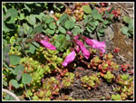
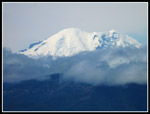
Janet was not comfortable with the scree and steep drop. After double knee replacement she did very well getting up and down the steep trail. She enjoyed the views while Gwen and I headed across. Some unusual flowers on the ridge. I don't know what they were. The last climb is steep but not nearly as much as it looks from a distance. In short order we were on the ridge top. Elbow is not well marked on maps. There is a first point then a higher on a little farther. There is another one on the same contour even farther. We stopped at the open point with the best views. To Rainier, Stuart and points east we now added all the peaks of the Cascade crest. From Lemah, Overcoat, the Chiefs, Bears Breast, Hinman and Daniel. Clouds up to the crest on the west side but clear looking from the east. Snow on parts of the ridge and lots of glacier lilies in bloom.
We had a short stay and headed down. Soon we met Janet. It was very warm for the 300' climb back to just under Yellow Hill. We saw two folks just above the trail on Yellow. They passed us coming down. They were the only people we saw all day. This is a very under appreciated trail, especially when the wildflowers are in bloom. We reached the car at 6:00 pm. Just about 8 1/2 hours on the trail. My GPS recorded 12.07 miles and while that is more than the books and the few other trip reports I think it is pretty accurate. It is most definitely more than the 10 miles mentioned in books. The short cuts on the road could reduce a little distance but not a mile or two. I recorded 4,083' of gain and that is just about right.
This was a good workout hike with some great views from Elbow Peak and wildflowers at the start, middle, and end. They never really let up. Add in great company and good weather along with almost no other people and this was a great day for a hike in the Teanaway.
Gwen's photos are here: NWHikers Photos
Click on thumbnails to get
larger pictures.
Photo Page 2
Trips - 2012
Home
We were packed and on our way at 9:35 am. The trailhead elevation is about 2850'. The trail goes around the tank traps blocking the road/trail. The first 1.6 miles in on road. There are a few shortcuts where a steep trail joins switchbacks. We stuck to the road up and down. We found a big patch of tiger lilies right at the start. The flower show never let up. It was a very good wildflower show. I sure was not expecting it. Having only hiked this trail in September and on snow I had no idea. The trail is one of the few in the Teanaway Valleys that allows motorcycles. This keeps some people away. It should not. On my first trip I saw one motorcycle. This time we saw none.
The tiger lilies gave way to Indian paintbrush and salsify and lupine. Lots and lots of lupine. In places the entire hillside above and below the road and later the trail was covered in blooming lupine. More than I have ever seen outside of the high mountain meadows. Far more than I have seen anywhere else this year. The spot forecast for 4000' was for a high near 60 degrees. It was much warmer than that. We were feeling the sun and heat at 10:00 am. Fortunately after the road section much of the way is in forest. Higher up there was a cooling wind. At the road end we headed steeply up the trail. This old trail is not gentle. There are a few switchbacks but for the most part it is straight up the hill.
At the ridge top, about 2.2 miles in, we stopped for a break. Gwen pointed out a find from an earlier trip, a few Tweedy's lewisia in bloom. Some very colorful penstemon too. The balsamroot was finishing down low but higher up it was still blooming. Add in some big patches of arnica for the yellows. Some phlox in various places too. The route has several ups and downs as it follows the ridge. Uphills late in the day coming out are always appreciated. In some deeper forest we had fading trillium, false Solomon's seal, and vanilla leaf. From desert to forest flowers in just a few minutes. After 22 years I had little recollection of the trail. On snow you just go straight up.
There was one spring high on the ridge as a pretty good small creek was running down the trail for a short distance. That was the only water of the day. It is a dry hike. As the trail began to contour around the east and north sides of Yellow Hill it became steeper. On open slopes we saw more paintbrush and blooming glacier lilies. The snow has not been gone long. The trail contours close to the top of Yellow Hill before dropping on the way to Elbow Peak. We hit snow about 60' below the top and chose to just go cross country to the top. There is a marker on the summit. the top is nearly flat and it's not much higher than the the area around it. Much different without 5 feet of snow. The summit is mostly forested. We did have a view north to Mt. Stuart and the Teanaway peaks. The top of Stuart was in the clouds. A fine place for a late lunch.
We soon were following the ridge down towards Elbow Peak. Where we met the trail it was snow free. The 300' drop is short and steep. The ridge below has some ups and downs but is the gentlest part of the trip. Forest, open ridge, some flowers, and some views out along the ridge. Sasse Ridge and Lake Cle Elum are in view now too. The clouds had departed from Stuart. It's a ways over to Elbow Peak. My GPS recorded nearly two miles. Just before the final climb is the open ridge. I recall crossing it back in 1990. The route across dropped steeply then contoured well below the ridge top. I recalled it being higher. It is. Coming back across I followed the more faint track just below the ridge. It's a steep slope but we did fine. This part is not really a trail not a difficult scramble. Some folks will not be comfortable. We had no problems.
Janet was not comfortable with the scree and steep drop. After double knee replacement she did very well getting up and down the steep trail. She enjoyed the views while Gwen and I headed across. Some unusual flowers on the ridge. I don't know what they were. The last climb is steep but not nearly as much as it looks from a distance. In short order we were on the ridge top. Elbow is not well marked on maps. There is a first point then a higher on a little farther. There is another one on the same contour even farther. We stopped at the open point with the best views. To Rainier, Stuart and points east we now added all the peaks of the Cascade crest. From Lemah, Overcoat, the Chiefs, Bears Breast, Hinman and Daniel. Clouds up to the crest on the west side but clear looking from the east. Snow on parts of the ridge and lots of glacier lilies in bloom.
We had a short stay and headed down. Soon we met Janet. It was very warm for the 300' climb back to just under Yellow Hill. We saw two folks just above the trail on Yellow. They passed us coming down. They were the only people we saw all day. This is a very under appreciated trail, especially when the wildflowers are in bloom. We reached the car at 6:00 pm. Just about 8 1/2 hours on the trail. My GPS recorded 12.07 miles and while that is more than the books and the few other trip reports I think it is pretty accurate. It is most definitely more than the 10 miles mentioned in books. The short cuts on the road could reduce a little distance but not a mile or two. I recorded 4,083' of gain and that is just about right.
This was a good workout hike with some great views from Elbow Peak and wildflowers at the start, middle, and end. They never really let up. Add in great company and good weather along with almost no other people and this was a great day for a hike in the Teanaway.
Gwen's photos are here: NWHikers Photos
 Tiger Lilies |
 Meadow Along Road |
 First Lupine |
 Daisy |
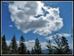 Puffy Clouds |
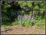 Roadside Lupine |
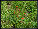 Indian Paintbrush |
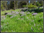 Grass & Lupine |
 Balsamroot |
 Bunch Of Arnica |
 Nearing Ridge Top |
 Flat Top Tree |
 Teanaway Peaks |
 Balsamroot On Ridge |
 Tweedy's Lewisia |
 Penstemon |
 Yellow Hill In Sight |
 Mt. Rainier |
 Winding Through Flowers |
 Thick With Lupine |
 Lupine & Paintbrush |
 Orange Paintbrush |
 Arnica Field |
 Lit Up Lupine |
 Vanilla Leaf |
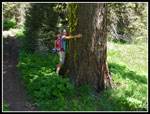 Tree Hugger |
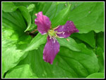 Trillium |
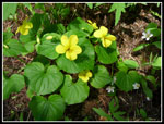 Violets & Spring Beauty |
 Glacier Lilies |
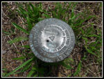 Yellow Hill Benchmark |
Photo Page 2
Trips - 2012
Home