9-8-13
I
have a few hikes I do almost every year. This is one of them. I
snowshoed up Teanaway Butte in March and had not returned to the
Teanaway River Valley since then. With a cooler summer day in store, I
chose to head east. Gwen joined me for her first time up Bean Peak and
around the rest of the loop. Other than the first few miles to Bean
Creek Basin this is not a very popular route. Being the week after
Labor Day I did not expect to meet many folks. I was not
disappointed. We met at the very early hour of 5:30 am in Bellevue and
headed east. We ran into a highway closure at Hyak as a big beam was
being brought in for the new Highway 522 bridge over the Snohomish
River. The road closed at 6:00 am. We arrived at 6:15 am. Up to a 1.5
hour wait. Not part of the plan. However, 20 minutes later the road
opened and we continued on our way. A stop in Cle Elum and we were soon
heading up the NF Teanaway Road. I noticed the small store along the
road has new owners and is once again open for business. The gravel
road is getting a little bumpier but is till in pretty good shape.
The useless drain ditches on the Beverly Creek Road have been dug open again. I bottomed out once. There has never been the least bit of water damage at that point. Totally useless unless the desire is to damage cars. they had filled in on my last visit but are nice and deep once again. Okay, off my soapbox for now. We arrived at the Beverly Creek trailhead at about 8:00 am to find two vehicles. It was cool in short sleeves but that's how I started. At least heading uphill we were able to warm up a bit.
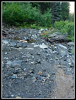
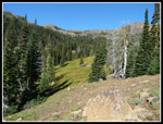
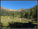
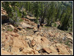
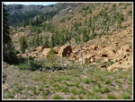
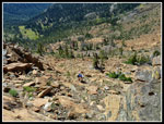
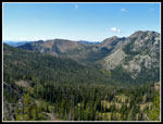
At Bean Creek we turned right and headed up the Bean Creek trail. The route is in good shape. Getting a little brushy but still not bad at all. I was a little surprised at the crossing of Bean Creek. the narrow crossing I remember is now twice as wide. The creek really roared through here since my last visit. The water level is low now but it will be interesting in the spring. On the other side of the creek we began to get a little morning sun and warmed up quickly. The steady climb brought us up to the lower basin. We crossed over the creek and checked out the start of the trail up and over the ridge to Standup Creek. Looks to be in better shape than I recall. I knew the trail was rebuilt into the upper basin and wondered if it now took off from this trail, There is a sign for the Bean Creek trail heading over the ridge. The trail that does not make the first creek crossing is unsigned and still goes up into the upper basin. That will confuses some folks.
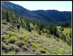
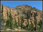
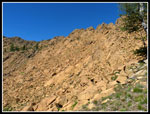
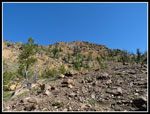
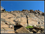
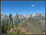
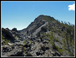
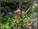
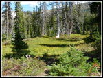
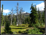
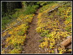
Back on track, we noticed where the new trail leaves the old one. Rather than going more or less straight up it makes a longer gentler switchback. This should cause much less erosion. At the bottom of the upper basin we found the junction with the old trail. It is well hidden and will soon be forgotten. The flowers are all gone as one would expect in September. We did find a few scarlet gilia hanging on and asters in places around the loop. The Indian paintbrush were few and far between. The grass basin is a combination of green and yellow and is quite colorful. Now came the fun part of the trip. 1100' of gain in about half a mile. I seldom take the popular route up to the ridge top to the right of Bean Peak. Instead we followed the boot path part way up then swung left towards the peak. After the heavy rains of the past week there was more water than usual this time of year.
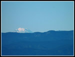
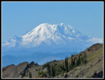
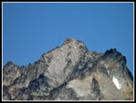
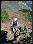
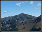
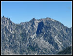
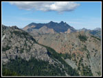
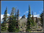
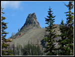
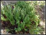
Lots of small ferns wafting in the wind. I went a little farther left than planned and found a very easy route on our knees. I managed to miss all the loose rock. That was okay with Gwen and me too. Gentian are starting to bloom all over the hillside. As we rose Mt. Rainier and Mt. Adams came into view. Still barely a cloud in the sky. It was warm but not "Teanaway in summer" warm. Soon enough we were beneath the summit. It is a fun scramble up the final 80 of so feet. Definitely not hiking but not a very difficult rock scramble. The views from the summit were excellent as usual. Clear in all directions. Just a few small clouds overhead. The south side of Mt. Stuart has almost no snow left. We sat and picked out the many peaks visible from the summit.
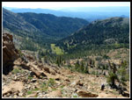
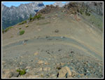
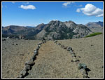
It was about 11:40 am when we reached the top. With our early start we had plenty of time left. After hiking the busiest trail on the route we had seen exactly zero people. We spent nearly an hour on top. At 12:35 pm we headed down the back side. We dropped down the ridge with Hardscrabble Basin to our right. Navaho Peak was visible to the east. I still have not hiked the old County Line trail through that basin. Soon we were down to the County Line trail at the base of Volcanic Neck. Gwen was especially interested in the shiny green rocks along here. The usual small number of rocks lining the trail were it crosses the ridge is now a long trail border. The trail was not washed out here since my visit two years ago. Easy switchbacks brought us down the slope.
I have always enjoyed the trail over to Fourth Creek Pass. Most unusual was that all the creeks were flowing. The recent rains seem to have really recharged the creeks. They would most all usually be dry in September. More gentians and even a healthy patch of red Indian paintbrush along here. We took a short break at the pass then dropped down to the Beverly Creek trail. A number of washouts in the last 10 years have made this trail much rockier in the upper basin. I so often hike up the valley to Iron Peak early in the year on snow and forget how much gravel has washed down the slope across the trail.
Part way down Gwen noticed a bag of very warm grapes on the side of the trail. Someone forget part of their lunch after a snack stop. We carried them out. A few minutes later Gwen noticed a bright orange rectangle on the side of the trail. I thought it was a marker for where trail work would be done. In fact, it was a hunting license. We took it and figured we could drop it in the mail to the owner whose address was on the license. The rest of the hike out was easy. Much softer footing once were were back in the forest. At the end of the day we still had not seen a single person. Who says there is no solitude on the trail? A fun 9 mile loop with about 3200' of elevation gain. Great views, one summit, a few flowers, and some fall color beginning. We planned to stop in Cle Elum on the way out for a mild shake. Why not deliver the license in person? Cle Elum is not a big town and with Internet connections we found the address with little difficulty. The owner was surprised to see his license. He did not even realize it had been lost. A real nice guy. We stayed around for awhile talking about the area the the trails.
By the time we left Cle Elum the traffic was light and it stayed that way all the way home. I had a great time as usual on this route. In another month the larch trees above the County Line trail will be bright yellow and snow will be in the offing. For now it was a warm clear day with total solitude on the trail.
The useless drain ditches on the Beverly Creek Road have been dug open again. I bottomed out once. There has never been the least bit of water damage at that point. Totally useless unless the desire is to damage cars. they had filled in on my last visit but are nice and deep once again. Okay, off my soapbox for now. We arrived at the Beverly Creek trailhead at about 8:00 am to find two vehicles. It was cool in short sleeves but that's how I started. At least heading uphill we were able to warm up a bit.
At Bean Creek we turned right and headed up the Bean Creek trail. The route is in good shape. Getting a little brushy but still not bad at all. I was a little surprised at the crossing of Bean Creek. the narrow crossing I remember is now twice as wide. The creek really roared through here since my last visit. The water level is low now but it will be interesting in the spring. On the other side of the creek we began to get a little morning sun and warmed up quickly. The steady climb brought us up to the lower basin. We crossed over the creek and checked out the start of the trail up and over the ridge to Standup Creek. Looks to be in better shape than I recall. I knew the trail was rebuilt into the upper basin and wondered if it now took off from this trail, There is a sign for the Bean Creek trail heading over the ridge. The trail that does not make the first creek crossing is unsigned and still goes up into the upper basin. That will confuses some folks.
Back on track, we noticed where the new trail leaves the old one. Rather than going more or less straight up it makes a longer gentler switchback. This should cause much less erosion. At the bottom of the upper basin we found the junction with the old trail. It is well hidden and will soon be forgotten. The flowers are all gone as one would expect in September. We did find a few scarlet gilia hanging on and asters in places around the loop. The Indian paintbrush were few and far between. The grass basin is a combination of green and yellow and is quite colorful. Now came the fun part of the trip. 1100' of gain in about half a mile. I seldom take the popular route up to the ridge top to the right of Bean Peak. Instead we followed the boot path part way up then swung left towards the peak. After the heavy rains of the past week there was more water than usual this time of year.
Lots of small ferns wafting in the wind. I went a little farther left than planned and found a very easy route on our knees. I managed to miss all the loose rock. That was okay with Gwen and me too. Gentian are starting to bloom all over the hillside. As we rose Mt. Rainier and Mt. Adams came into view. Still barely a cloud in the sky. It was warm but not "Teanaway in summer" warm. Soon enough we were beneath the summit. It is a fun scramble up the final 80 of so feet. Definitely not hiking but not a very difficult rock scramble. The views from the summit were excellent as usual. Clear in all directions. Just a few small clouds overhead. The south side of Mt. Stuart has almost no snow left. We sat and picked out the many peaks visible from the summit.
It was about 11:40 am when we reached the top. With our early start we had plenty of time left. After hiking the busiest trail on the route we had seen exactly zero people. We spent nearly an hour on top. At 12:35 pm we headed down the back side. We dropped down the ridge with Hardscrabble Basin to our right. Navaho Peak was visible to the east. I still have not hiked the old County Line trail through that basin. Soon we were down to the County Line trail at the base of Volcanic Neck. Gwen was especially interested in the shiny green rocks along here. The usual small number of rocks lining the trail were it crosses the ridge is now a long trail border. The trail was not washed out here since my visit two years ago. Easy switchbacks brought us down the slope.
I have always enjoyed the trail over to Fourth Creek Pass. Most unusual was that all the creeks were flowing. The recent rains seem to have really recharged the creeks. They would most all usually be dry in September. More gentians and even a healthy patch of red Indian paintbrush along here. We took a short break at the pass then dropped down to the Beverly Creek trail. A number of washouts in the last 10 years have made this trail much rockier in the upper basin. I so often hike up the valley to Iron Peak early in the year on snow and forget how much gravel has washed down the slope across the trail.
Part way down Gwen noticed a bag of very warm grapes on the side of the trail. Someone forget part of their lunch after a snack stop. We carried them out. A few minutes later Gwen noticed a bright orange rectangle on the side of the trail. I thought it was a marker for where trail work would be done. In fact, it was a hunting license. We took it and figured we could drop it in the mail to the owner whose address was on the license. The rest of the hike out was easy. Much softer footing once were were back in the forest. At the end of the day we still had not seen a single person. Who says there is no solitude on the trail? A fun 9 mile loop with about 3200' of elevation gain. Great views, one summit, a few flowers, and some fall color beginning. We planned to stop in Cle Elum on the way out for a mild shake. Why not deliver the license in person? Cle Elum is not a big town and with Internet connections we found the address with little difficulty. The owner was surprised to see his license. He did not even realize it had been lost. A real nice guy. We stayed around for awhile talking about the area the the trails.
By the time we left Cle Elum the traffic was light and it stayed that way all the way home. I had a great time as usual on this route. In another month the larch trees above the County Line trail will be bright yellow and snow will be in the offing. For now it was a warm clear day with total solitude on the trail.
 Wolf Info |
 Creek Crossing |
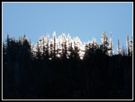 Lit Up Trees |
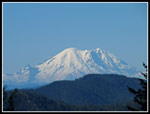 Mt. Rainier |
 Bean Creek Basin |
 Mt. Adams |
 Basin & Peak |
 Hiking Above Basin |
 Small Ferns |
 Climbing Slabs |
 Ramp To Summit |
 Bean Peak Ridge |
 Grassy Ramp |
 Under Summit |
 Rainier Over Ridge |
 Basin Below |
 Summit Scramble |
 Gwen At Scramble |
 Gwen Atop Bean Peak |
 Mt. Stuart Summit |
 Heading Down |
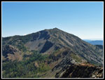 Earl Peak |
 Navaho Peak |
 McClellan Peak |
 Stuart Range |
 Fourth Creek Pass |
 Bean Summit |
 County Line Trail |
 Trail Border |
 Ingalls Peaks |
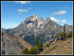 Mt. Stuart |
 Volcanic Neck |
 Puffy Clouds |
 Indian Paintbrush |
 Meadow |
 Meadow & Bean Pk |
 V Neck Again |
 More Ferns |
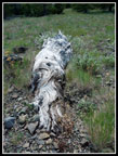 Silver Log |
 Fall Color |
Trips - 2013
Home