2-17-14
The
story of this trip report
began a long long time ago. Back in th spring of 1971 I was in the
sixth grade. All sixth graders in the Highline School District get to
attend a week at Camp Waskowitz. Some far sighted folks at the district
began sending students for a week of environmental education far before
there was much of an environmental movement. The site is one of only
two out of over 4000 Depression era Civilian Conservation Corps (CCC)
camps with all the original buildings standing, per the Waskowitz
website. Camp North Bend was
built in 1935 and housed several hundred young men between the ages of
18-25. They built the North Bend Ranger Station and Denny Creek
Campgrounds among other actions. In 1942 the US was at war and with
young men headed to the military the CCC was disbanded. Just
five years later with the war over the Highline School District began
using the facility. In 1957 they purchased it. There was not much to
North Bend at that time. Highway 10 went through town. The 1960
population was 945. By 1970 it had mushroomed to 1,625. The camp seemed
far out in the woods. That's how I remember my week in 1971.
It wasn't until decades later that I found the camp on a map. Now it sits just a block away from Interstate 90. The endless forest I remembered is surrounded by housing. The 372 acres the district amassed is now an oasis at the edge of the city. I recalled all the trails and meant to see if I could come back and hike them as an adult. The idea came up occasionally but I never seemed to get around to it. The relatively small area is not somewhere I would spend a day when the mountains beckon in the summer. Now on a wet winter day... that's a different matter. I contacted the camp last December and was told I could visit when there was no group there.
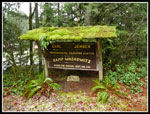
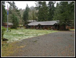
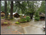
Into the new year I looked for a free weekend day and found the perfect one on Presidents Day. I called and found I could visit. There is a caretaker there but otherwise I would not be bothering anyone. Kim is another history buff and she signed on. After a very dry early winter we began to catch up with a vengeance this weekend. Feet of snow falling in the mountains. Lots of rain and wind in the lowlands. A fine day for a short close in hike. Snoqualmie Pass was closed all morning at the 468th St exit where we would normally leave the freeway. With a long backup of cars I took the old Highway 10 route through North Bend. Cars and semis parked all along the roads within a mile of the freeway. We drove by and on to the camp. Before hiking the trails we spent time walking through the old camp. It is in fine shape for going on 79 years old.
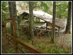
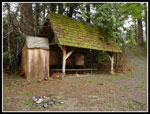
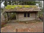
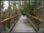
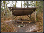
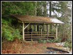
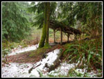
I recalled a number of the old buildings. There are a few new ones like a covered shelter down by the SF Snoqualmie River. It brought back a lot of old memories. There is a map online and the person I spoke with on the phone taped a copy on the main office door for me. A nice touch. I had a map with no topo lines and a GPS with no trails. It made for some interesting navigation. There are a number of shelters along the trails. There are a number of trails in a small area. I knew the old Stampede Pass fire lookout had been helicoptered over to the camp. I thought it was before my visit. I was wrong. It was in 1974, three years after I attended the camp. I have visited a number of lookouts but not this one until this day. When the camp is closed they lock gates at each end of the bridge over the river. I had the okay to climb over them on the way to the main trails. They were a little taller than I was expecting.
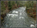
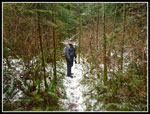
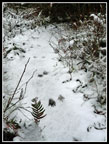
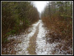
Much to my surprise there was a little snow at the 560' camp. Not much but the bridge was very slick when we crossed it. I did not expect to see any snow below about 1400'. We headed along the river taking the fire sculpture trail. We soon found one of the many shelters. Not such a bad thing on a cold rainy day in February. The old Chicago, Milwaukee, & St. Paul Railroad Grade is along the south bank of the river. It is now the Snoqualmie Valley Trail. We crossed over and began to head uphill towards the lookout. I decided on a counter clockwise loop that would give us a good flavor of the trail system while hitting a number of shelters, the lookout, and the Big Fir tree.
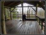
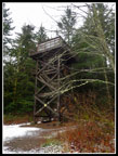
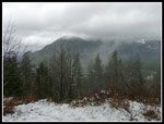
Most junctions are well signed so we managed to stay on route. We reached the lookout at about 900' elevation. There was a little snow on the ground. The lookout has a locked door at the bottom and barbed wire higher up to deter unwelcome visitors. There is a big enough clearing at the base to see out to Little Si, Mt. Si, and Mt Teneriffe. At least the bottom of them. The tops were lost in the low clouds. Next time I hike up Si I'll bring binoculars and try to find the lookout. We took a break under the roof of the shelter. Our umbrellas were getting quite a workout. Here is a link to info on the lookout and it's move to Camp Waskowitz. The book referenced abut lookouts is excellent. I own it and recommend it.
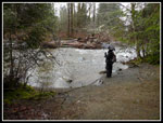
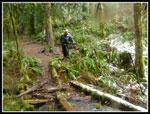
There is a road and several trails leaving the lookout. One trail follows near the west border of the property. We chose one just to the east of it. There will be lots of salmonberry and assorted brush in a few months along the trail. For now it is very open. Many nurse logs along the way. Signs of fire, and some logging in spots. Also some big old trees in other spots. Our route crossed several roads, the one to the lookout in good shape the other more overgrown. We passed the Olallie Shelter and soon came to Porcupine Creek. I checked out the Burma Bridge Shelter then rejoined Kim at the creek. The creek is crossable with a big jump or there is the bridge. Kim chose the bridge crossing. I jumped across first and filmed her crossing the bridge.
The Burma Bridge is one lower and two parallel higher cables. Rope goes from one high cable to the lower one and up to the other high cable. This provides a little stability to allow walking on the one cable while using the other two as handrails. I'm confident that on this cold rainy day I would have been able to fall off of it and into the creek. Kim took her chances. She did good. Made it right across. I'll post the video with the photos below. We passed another very nice shelter and descended down towards the Big Fir. Except we missed it. The map showed the trail to the Burma Bridge Shelter continuing on the other side of the creek and later crossing over and meeting our trail. What Seemed to be that trail was not. We continued on a trail that took us away from the Big Tree. I was soon clear we were going in the wrong direction. Map and GPS did not seem to agree. We went back to that junction and that route proved to be the correct one.
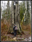
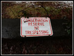
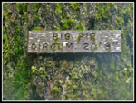
The Big Fir is not the largest Douglas Fir I have seen but it's not small either. A sign lists it at 20' 8" in circumference. From there we had a short hike back to the Snoqualmie Valley Trail and on to the bridge over the Snoqualmie River. Somehow I had managed to lose one glove and the hat right off my head in the course of the day. That's as many gloves and hats as I have lost in 30+ years of hiking. But it was well worth it. The Camp Waskowitz trail system is on private land. They are not trails I will often hike. It was a lot of fun to return to one of the events of my childhood that moved me towards a life in the outdoors. From hikes at Camp Waskowitz I moved on to 800 - 1000 mile years on the trail. Add in the history of one of only two CCC camps completely intact and this history and hiking buff had a great time. I think Kim will agree with me.
In summary, the camp and lookout can be visited. They are on private property. Please contact the camp and ask permission rather than trespassing on their land. They were very gracious with me and I would hate for them to feel the need to put up fences to keep folks out. The camp is in use weekdays much of the year by the school district and on a rental basis as a meeting place. It is not in use December - February and on most weekends. That would be the time to ask to visit.
Trips - 2014
Home
It wasn't until decades later that I found the camp on a map. Now it sits just a block away from Interstate 90. The endless forest I remembered is surrounded by housing. The 372 acres the district amassed is now an oasis at the edge of the city. I recalled all the trails and meant to see if I could come back and hike them as an adult. The idea came up occasionally but I never seemed to get around to it. The relatively small area is not somewhere I would spend a day when the mountains beckon in the summer. Now on a wet winter day... that's a different matter. I contacted the camp last December and was told I could visit when there was no group there.
Into the new year I looked for a free weekend day and found the perfect one on Presidents Day. I called and found I could visit. There is a caretaker there but otherwise I would not be bothering anyone. Kim is another history buff and she signed on. After a very dry early winter we began to catch up with a vengeance this weekend. Feet of snow falling in the mountains. Lots of rain and wind in the lowlands. A fine day for a short close in hike. Snoqualmie Pass was closed all morning at the 468th St exit where we would normally leave the freeway. With a long backup of cars I took the old Highway 10 route through North Bend. Cars and semis parked all along the roads within a mile of the freeway. We drove by and on to the camp. Before hiking the trails we spent time walking through the old camp. It is in fine shape for going on 79 years old.
I recalled a number of the old buildings. There are a few new ones like a covered shelter down by the SF Snoqualmie River. It brought back a lot of old memories. There is a map online and the person I spoke with on the phone taped a copy on the main office door for me. A nice touch. I had a map with no topo lines and a GPS with no trails. It made for some interesting navigation. There are a number of shelters along the trails. There are a number of trails in a small area. I knew the old Stampede Pass fire lookout had been helicoptered over to the camp. I thought it was before my visit. I was wrong. It was in 1974, three years after I attended the camp. I have visited a number of lookouts but not this one until this day. When the camp is closed they lock gates at each end of the bridge over the river. I had the okay to climb over them on the way to the main trails. They were a little taller than I was expecting.
Much to my surprise there was a little snow at the 560' camp. Not much but the bridge was very slick when we crossed it. I did not expect to see any snow below about 1400'. We headed along the river taking the fire sculpture trail. We soon found one of the many shelters. Not such a bad thing on a cold rainy day in February. The old Chicago, Milwaukee, & St. Paul Railroad Grade is along the south bank of the river. It is now the Snoqualmie Valley Trail. We crossed over and began to head uphill towards the lookout. I decided on a counter clockwise loop that would give us a good flavor of the trail system while hitting a number of shelters, the lookout, and the Big Fir tree.
Most junctions are well signed so we managed to stay on route. We reached the lookout at about 900' elevation. There was a little snow on the ground. The lookout has a locked door at the bottom and barbed wire higher up to deter unwelcome visitors. There is a big enough clearing at the base to see out to Little Si, Mt. Si, and Mt Teneriffe. At least the bottom of them. The tops were lost in the low clouds. Next time I hike up Si I'll bring binoculars and try to find the lookout. We took a break under the roof of the shelter. Our umbrellas were getting quite a workout. Here is a link to info on the lookout and it's move to Camp Waskowitz. The book referenced abut lookouts is excellent. I own it and recommend it.
There is a road and several trails leaving the lookout. One trail follows near the west border of the property. We chose one just to the east of it. There will be lots of salmonberry and assorted brush in a few months along the trail. For now it is very open. Many nurse logs along the way. Signs of fire, and some logging in spots. Also some big old trees in other spots. Our route crossed several roads, the one to the lookout in good shape the other more overgrown. We passed the Olallie Shelter and soon came to Porcupine Creek. I checked out the Burma Bridge Shelter then rejoined Kim at the creek. The creek is crossable with a big jump or there is the bridge. Kim chose the bridge crossing. I jumped across first and filmed her crossing the bridge.
The Burma Bridge is one lower and two parallel higher cables. Rope goes from one high cable to the lower one and up to the other high cable. This provides a little stability to allow walking on the one cable while using the other two as handrails. I'm confident that on this cold rainy day I would have been able to fall off of it and into the creek. Kim took her chances. She did good. Made it right across. I'll post the video with the photos below. We passed another very nice shelter and descended down towards the Big Fir. Except we missed it. The map showed the trail to the Burma Bridge Shelter continuing on the other side of the creek and later crossing over and meeting our trail. What Seemed to be that trail was not. We continued on a trail that took us away from the Big Tree. I was soon clear we were going in the wrong direction. Map and GPS did not seem to agree. We went back to that junction and that route proved to be the correct one.
The Big Fir is not the largest Douglas Fir I have seen but it's not small either. A sign lists it at 20' 8" in circumference. From there we had a short hike back to the Snoqualmie Valley Trail and on to the bridge over the Snoqualmie River. Somehow I had managed to lose one glove and the hat right off my head in the course of the day. That's as many gloves and hats as I have lost in 30+ years of hiking. But it was well worth it. The Camp Waskowitz trail system is on private land. They are not trails I will often hike. It was a lot of fun to return to one of the events of my childhood that moved me towards a life in the outdoors. From hikes at Camp Waskowitz I moved on to 800 - 1000 mile years on the trail. Add in the history of one of only two CCC camps completely intact and this history and hiking buff had a great time. I think Kim will agree with me.
In summary, the camp and lookout can be visited. They are on private property. Please contact the camp and ask permission rather than trespassing on their land. They were very gracious with me and I would hate for them to feel the need to put up fences to keep folks out. The camp is in use weekdays much of the year by the school district and on a rental basis as a meeting place. It is not in use December - February and on most weekends. That would be the time to ask to visit.
 Sign On The Road In |
 Welcome |
 Camp Waskowitz |
 Living Quarters |
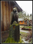 Carved Eagle |
 Riverside Shelter |
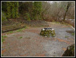 Campfire Spot |
 Wooden Canoes |
 Mossy Shelter |
 Kim By The River |
 Log Cabin |
 River From Bridge |
 Slick Slushy Bridge |
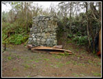
 Fire Sculpture |
 Fire Sculpture Shelter |
 Inside Tower Shelter |
 Lookout Tower |
 View To Mt. Si |
 Lookout Shelter |
 Conservation Reserve |
 Snowy Trail |
 Paw Prints |
 Green & Orange |
 Olallie Shelter |
 Narrow Road/Trail |
 Burma Bridge |
 Big Fir Tree |
 20'8" In Circumference |
 Skunk Cabbage! |
 Information Sign |
Burma Bridge from Jim Kuresman on Vimeo.
Click on thumbnails to get larger pictures.Trips - 2014
Home