Fortune Peak
6-07-14
Gwen
wanted to scramble up Fortune
Peak in the Teanaway. Kim wanted to do a more strenuous hike high in
the mountains. I had not done it since 2006. Fortune is a fun scramble.
I have been up it half a dozen times and never by the same route. For
this trip I planned to head to the ridge above Lake Ann and scramble up
from there. The amount of snow was a bit of a mystery. We brought ice
axes but no snowshoes. We met in Bellevue at 7:00 am and headed east.
By Cle Elum and up Highway 970 to the NF Teanaway road. The first mile
of dirt after the end of pavement is full of pot holes. It gets better
after that. We cruised into the 4300' parking lot at the end of the
road to find it only a little more than half full at 9:05 am. We were
soon on our way.
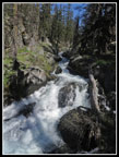
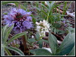
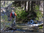
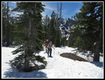
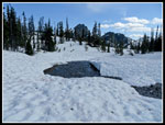
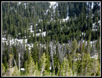
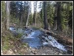
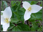
I expected the many creeks along the Esmerelda Basin Trail to be running high. I was not disappointed. With gaiters on I stomped through them with dry feet. We found a good assortment of wildflowers in bloom. not the color that will be out in a few weeks but not bad. Lots of shooting stars were in bloom. There was some snow down low in the shaded area near and across the creek. The bulk of East Esmerelda Peaks block out the sun most of the day. The trail only had patches near the first switchback and in places above that. After two miles at the 5300' level we lost the trail under several feet of snow. It was not completely snow covered ground as higher on the slope it was much thinner with dirt showing through.
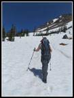
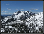
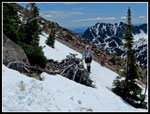
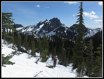
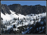
We decided to angle uphill rather than try to find and stay on the summer route. At first the going was very easy. The forest is quite open and the snow deep enough to provide for easy walking. As we climbed the slope began to steepen. Rather than side hill around to the basin the trail ascends to the pass above Lake Ann, we chose a more direct uphill route. Some steep climbing on snow and then dirt brought us to a large bench. We now angled to our left on better terrain. We were soon back on snow. It was deep and hard enough to avoid post holing but soft enough to kick solid steps. We traversed around to a ridge and could have dropped down to the basin now below. Instead we traversed the slope on snow and scree patches hoping to intersect the ridge leading to the summit of Fortune. This was a much different route than I had down before.
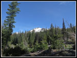
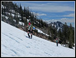
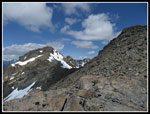
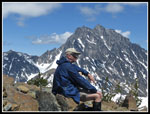
We reached some steep snow slopes where it was prudent to take out our ice axes. After those one last snow climb did in fact take us to the correct ridge. The wind was blowing hard but the sun was shining. It was warm out of the wind and not so much in the wind. Kim decided that this 6500' viewpoint was a good spot to enjoy while Gwen and I went for the summit. Kim did very well for her first snowy off trail hike of the year. I had to put on a jacket due to the wind. I don't like steep scrambling in a jacket but it was too windy to not have it on. I had only been up the ridge not down and that was eight years ago. The boot path is mostly visible. The route goes on or just right of the ridge all the way up. The GPS recorded 800' of gain in .50 miles to the summit.
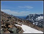
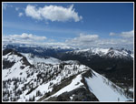
The scramble was a lot of fun. Some loose rock and a few moves to avoid snow on the route. Be moving a little closer to the crest of the ridge we did not have to cross any snow. The steepest parts are near the bottom. After about 50+ minutes we reached the top. The rocks were all bare. No summit register to be found. I was a little surprised to not see any tracks on snow around the top. We were certainly the first on top this day. It had only been three weeks since we summited Iron Peak but the view of Mt. Stuart showed a whole lot less snow. Ingalls Lake, right below us, was still frozen over. The gap in the ridge of Esmerelda Peaks showed snow covered Gallagher Head Lake. . Fortune Peak is a very nice viewpoint.
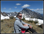
We spent about 30 minutes on top admiring all the views. Unlike most of the ridge coming up the summit breeze was much more gentle. When we did start down it did not take long to get back into the teeth of the wind. The steep ridge is a bit of a knee cruncher. We made a little better time, getting back to the bottom in 42 minutes. All in all, we took two hours to get up and back down. Kim seemed to be enjoying the views and the wispy clouds blowing by. We took a break and then headed down.
Rather than retrace our steps with all the side hilling we followed the ridge towards the saddle where the summer trail crosses over. Before the saddle, we headed straight down the slope. The snow was soft enough that our glissade attempts were pretty pathetic. Still, we had to try. Walking down the snow was pretty easy. We headed straight down just east of the summer route. This trip proved to be a great hike but an electronic disaster. The day began with me picking up my pack and boots at home and walking out with my camera on the living room floor. I had charged my phone battery so at least I had a back up camera. I did until we reached the trailhead and my fully charged battery showed almost no juice left. Strike two. All photos for this trip are courtesy of Gwen Tollefson who had the only operating camera. Kim put a memory card in her camera that morning and it would not work. She left the camera at home. When she returned home it worked perfectly. Gwen's altimeter watch screen was blanking out and coming back all day long. I tried to coax a few photos out of my phone and it froze up entirely. I could not even turn it off. When I returned home it worked once again. It was a strange day.
The last piece of electronics was my GPS. My rock solid GPS. On the way up it threw in an 87.5 mile outlier point. It thought we traveled that distance in 9 seconds. That 34,000 mph trek messed up our average speed for the day. Coming down from the saddle I expected to use the GPS to track the summer trail and find it even under many feet of snow. That did work until the map suddenly disappeared. We could navigate fine without the GPS but it did make it easier to find the dirt trail once again. Lower down the map mysteriously reappeared. We dropped down and found the summer trail on the long switchbacks below the junction to Fortune Pass. We were on and off snow until we reached the bare trail where we lost it in the morning.
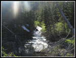
The rest of the way back was easy as the trail is very gently graded. The creek crossings seemed to be even a little deeper than earlier but in the last few miles dry feet are not so important. We reached the parking lot at about 6:15 pm. There were still 8 or 9 cars. Some folks likely were camping. This was a fun day. Some easy trail, some off trail scrambling, and a steep ridge scramble to a great summit viewpoint. I have enjoyed all the various routes I have taken up Fortune Peak. Due to the late hour we stopped in Cle Elum for dinner making this a 16+ hour day hike from door to door.
All photos courtesy of Gwen Tollefson.
Click on thumbnails to get
larger pictures.
Trips - 2014
Home
I expected the many creeks along the Esmerelda Basin Trail to be running high. I was not disappointed. With gaiters on I stomped through them with dry feet. We found a good assortment of wildflowers in bloom. not the color that will be out in a few weeks but not bad. Lots of shooting stars were in bloom. There was some snow down low in the shaded area near and across the creek. The bulk of East Esmerelda Peaks block out the sun most of the day. The trail only had patches near the first switchback and in places above that. After two miles at the 5300' level we lost the trail under several feet of snow. It was not completely snow covered ground as higher on the slope it was much thinner with dirt showing through.
We decided to angle uphill rather than try to find and stay on the summer route. At first the going was very easy. The forest is quite open and the snow deep enough to provide for easy walking. As we climbed the slope began to steepen. Rather than side hill around to the basin the trail ascends to the pass above Lake Ann, we chose a more direct uphill route. Some steep climbing on snow and then dirt brought us to a large bench. We now angled to our left on better terrain. We were soon back on snow. It was deep and hard enough to avoid post holing but soft enough to kick solid steps. We traversed around to a ridge and could have dropped down to the basin now below. Instead we traversed the slope on snow and scree patches hoping to intersect the ridge leading to the summit of Fortune. This was a much different route than I had down before.
We reached some steep snow slopes where it was prudent to take out our ice axes. After those one last snow climb did in fact take us to the correct ridge. The wind was blowing hard but the sun was shining. It was warm out of the wind and not so much in the wind. Kim decided that this 6500' viewpoint was a good spot to enjoy while Gwen and I went for the summit. Kim did very well for her first snowy off trail hike of the year. I had to put on a jacket due to the wind. I don't like steep scrambling in a jacket but it was too windy to not have it on. I had only been up the ridge not down and that was eight years ago. The boot path is mostly visible. The route goes on or just right of the ridge all the way up. The GPS recorded 800' of gain in .50 miles to the summit.
The scramble was a lot of fun. Some loose rock and a few moves to avoid snow on the route. Be moving a little closer to the crest of the ridge we did not have to cross any snow. The steepest parts are near the bottom. After about 50+ minutes we reached the top. The rocks were all bare. No summit register to be found. I was a little surprised to not see any tracks on snow around the top. We were certainly the first on top this day. It had only been three weeks since we summited Iron Peak but the view of Mt. Stuart showed a whole lot less snow. Ingalls Lake, right below us, was still frozen over. The gap in the ridge of Esmerelda Peaks showed snow covered Gallagher Head Lake. . Fortune Peak is a very nice viewpoint.
We spent about 30 minutes on top admiring all the views. Unlike most of the ridge coming up the summit breeze was much more gentle. When we did start down it did not take long to get back into the teeth of the wind. The steep ridge is a bit of a knee cruncher. We made a little better time, getting back to the bottom in 42 minutes. All in all, we took two hours to get up and back down. Kim seemed to be enjoying the views and the wispy clouds blowing by. We took a break and then headed down.
Rather than retrace our steps with all the side hilling we followed the ridge towards the saddle where the summer trail crosses over. Before the saddle, we headed straight down the slope. The snow was soft enough that our glissade attempts were pretty pathetic. Still, we had to try. Walking down the snow was pretty easy. We headed straight down just east of the summer route. This trip proved to be a great hike but an electronic disaster. The day began with me picking up my pack and boots at home and walking out with my camera on the living room floor. I had charged my phone battery so at least I had a back up camera. I did until we reached the trailhead and my fully charged battery showed almost no juice left. Strike two. All photos for this trip are courtesy of Gwen Tollefson who had the only operating camera. Kim put a memory card in her camera that morning and it would not work. She left the camera at home. When she returned home it worked perfectly. Gwen's altimeter watch screen was blanking out and coming back all day long. I tried to coax a few photos out of my phone and it froze up entirely. I could not even turn it off. When I returned home it worked once again. It was a strange day.
The last piece of electronics was my GPS. My rock solid GPS. On the way up it threw in an 87.5 mile outlier point. It thought we traveled that distance in 9 seconds. That 34,000 mph trek messed up our average speed for the day. Coming down from the saddle I expected to use the GPS to track the summer trail and find it even under many feet of snow. That did work until the map suddenly disappeared. We could navigate fine without the GPS but it did make it easier to find the dirt trail once again. Lower down the map mysteriously reappeared. We dropped down and found the summer trail on the long switchbacks below the junction to Fortune Pass. We were on and off snow until we reached the bare trail where we lost it in the morning.
The rest of the way back was easy as the trail is very gently graded. The creek crossings seemed to be even a little deeper than earlier but in the last few miles dry feet are not so important. We reached the parking lot at about 6:15 pm. There were still 8 or 9 cars. Some folks likely were camping. This was a fun day. Some easy trail, some off trail scrambling, and a steep ridge scramble to a great summit viewpoint. I have enjoyed all the various routes I have taken up Fortune Peak. Due to the late hour we stopped in Cle Elum for dinner making this a 16+ hour day hike from door to door.
All photos courtesy of Gwen Tollefson.
 NF Teanaway River |
 Fortune Peak In Sight |
 Wildflowers |
 Kim Crossing Creek |
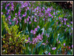 Shooting Stars |
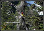 Western Tanager |
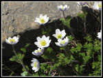 Western Anemone |
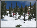
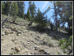 Steep Off Trail |
 Back On Snow |
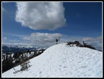
 Summit Ridge Ahead |
 More Snow Travel |
 Traversing Talus Field |
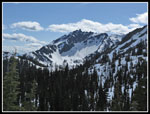
 Hawkins Mountain |
 Crossing Thin Snow |
 Scrambling Ridge |
 South Ingalls Peak |
 Jim On Summit |
 Gwen Atop Fortune Peak |
 Fortune Ridge |
 Kim On Ridge |
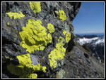 Bright Lichen |
 Scouting Way Down |
 Descending |
 Shadows |
 Traversing Lower |
 Flowing Snow Melt |
 Valley Below |
 Long Shadows |
 Higher Creeks |
 Trillium |
 Teanaway River |
Trips - 2014
Home