5-03-14
Kim
arranged a hike with mytho-man (David Hagen) from WTA trip reports. He
and a
group of other Cascadian club members hike out of the Yakima area. Kim,
Anna, and I met in Bellevue at 7:05 am and headed east. It was damp and
cloudy on the drive until past Easton when the sky began to clear. We
made a couple stops along the way and arrived at the Yakima Ranger
Station at 9:45 am. We met the Cascadians and were soon on our way to
the trailhead. a few miles later, just after the junction of
Highways 12 and 410 we left 410 into the dirt parking lot at the base
of Waterworks Canyon. At 10:05 we were packed up and went through the
fence gate onto our route. There is an obvious trail heading up the
canyon. David planned a loop trip coming out the canyon. Right beyond
the gate we crossed the creek bed and headed up onto the base of the
ridge.
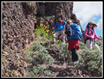
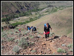
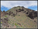
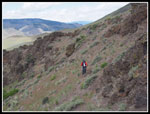
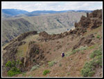
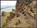
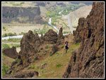
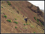
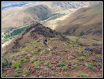
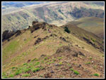
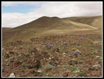
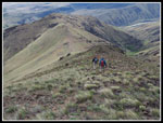
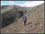
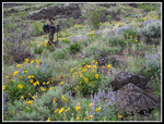
It's easy walking as there is little brush. A short way up we found the boot path. While not a trail, the boot path is fairly obvious as it climbs high above the creek. There are also a number of animal tracks and a few trails that contour below the ridge top. I believe that one can stay mostly on the ridge. We took a detour part way up. There were a few clouds moving in but the sky was mostly blue. The forecast for wind was upgraded in the morning. It was steady but never became too strong. The trailhead is at about 1640'. The ridge climbs rapidly and moves through a number of plant zones. The balsamroot is near its end down low. It gets better higher up.
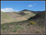
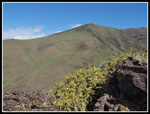
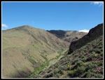
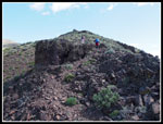
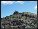
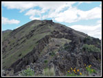
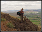
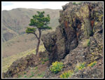
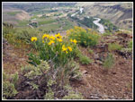
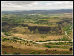
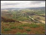
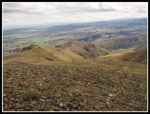
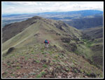
I was expecting the ridge to be a moderately steep walk up grassy slopes. In fact there are some neat rock formations along the way. After each steep section we waited and reformed the group on short flatter spots. The views of the west side of the canyon were excellent. Green grasses with sun and shadows. The greener creek bed in the canyon was very green. To the west we could see snowy peaks of the Nelson Ridge area. I was there last year on a scramble up Mt. Aix. Right below us was the junction of the Tieton River and the Naches. The Tieton comes from a dammed reservoir and is very clear. The Naches is much browner with silt. Off to the east we could see Yakima down the Naches Valley. The view became even better as we climbed higher.
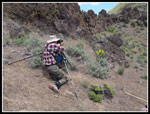
Someone noticed small white dots far ahead of us. My maximum zoom brought in three big horned sheep. I have seldom seen them in Washington. We took a detour David suggested. it took us below the ridge through some neat rock formations. The tread was pretty minimal as we side hilled on steep terrain. After heading far to the right we swichbacked to the ridge and picked up the main track once again. Someone noticed a lizard and it just froze while everyone stopped to take a photo. That was not the last wildlife sighting of the day.
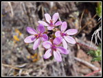
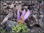
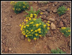
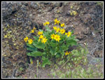
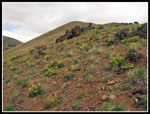
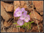
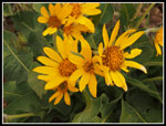
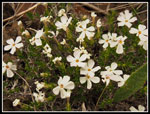
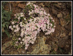
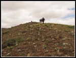
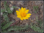
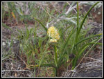
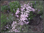
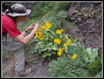
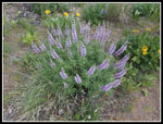
The overall wildflower display was very good. Not acres of yellow and blue but a wide variety of flowers and colors. White and pink phlox was seen in many places. Also penstemon and larkspur on the middle ridge. There were a number of small pink and lavender flowers whose name I can't recall. As the ridge flattened the rock garden exploded with ground hugging color. I was more than ready for lunch when we reached the false summit. Our pace was slowed by all the views and wildflowers. Much time was taken up with photography. We had hiked about 2+ miles gaining 1700' in 2:45. It was almost 1:00 pm and I was more than read for lunch. There was some wind but less than we had felt down lower.
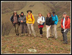
Now came decision time. Some of the Cascadians wanted to drop to the saddle then continue higher up to the main east-west ridge of Cleman Mountain. The real summit was several miles to the west but from the upper point on the main ridge views would open up to the north as well. Mts. Rainier and Adams along with the Cascade Crest were lost in cloud. We would have better views but not those seen on a totally clear day. We had about the same distance and elevation gain to go as the trip up to this point. David, our Kim, and Ethan chose to enjoy the false summit and then head down to Waterworks Canyon on the way out. Anna, Cascadian Kim, Bill, Phil, and I chose to continue higher. We dropped down to the saddle and removed some clothing. It would be warmer heading uphill at a faster pace.
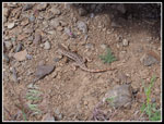
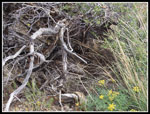
We set a good steady pace as we headed up. After a steeper start the upper ridge flattened and again we found some great color from low growing wildflowers. Near the top we even saw some yellowbells just beginning to bloom. There are old roads on top. We ended at a very nice viewpoint. The Stuart Range was largely in clouds. Speaking of clouds they had thickened overhead. Still no rain but we went from sunshine to dark and cloudy over and over again. Going down was not much faster. They cameras were stowed for much of the ascent. The scenery was too spectacular to repeat that on the way down. They are not quite ready to bloom but we did see bitterroot flowers about to pop. In one spot I even noticed blooming wallflower. As had been the case most of the day, not profusion but great wildflower variety. On the way back down we had a rattlesnake sighting. In all my years of hiking east of the crest I have only had half a dozen hikes where I saw rattlesnakes Half of them have been the last two years.
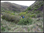
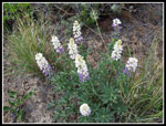
Back at the saddle we followed the very sketchy trail that drops down to the canyon bottom. Sketchy but far better than trying to drop down the steep and loose rock slope. Down at the creek bed I discovered the creek was dry. In places it was running but for the most part it is finished. There is a lot of greenery and wildflowers. I saw several flowers there that I did not see on the ridge. Among them were woodland stars, ballhead waterleaf, service berry, death camas, and more. The most interesting sighting was on a slope of balsamroot and lupine. We caught up with Kim, David, and Ethan here. One bunch of lupine was blue at the bottom and white on top. A most unusual flower. We also saw another rattlesnake in the canyon.
It was after 5:00 pm when we reached the trailhead. For the day we hiked a little over 8 miles with about 3400' of elevation gain. Until we reached the canyon there was precious little shade. I was thankful for the afternoon clouds and the wind. If it had been 85 degrees and sunny I would not have fared well. This will be a spring or fall hike for me. We joined the locals for dinner in Yakima then headed home. From Cabin Creek on it rained the whole way, hard at times. It was nice to have had a mostly sunny day when the west side was gray and wet. Special thanks to the Cascadians for their great hospitality. Kim, Ana, and I had a great time.
Click on thumbnails to get
larger pictures.
Trips - 2014
Home
It's easy walking as there is little brush. A short way up we found the boot path. While not a trail, the boot path is fairly obvious as it climbs high above the creek. There are also a number of animal tracks and a few trails that contour below the ridge top. I believe that one can stay mostly on the ridge. We took a detour part way up. There were a few clouds moving in but the sky was mostly blue. The forecast for wind was upgraded in the morning. It was steady but never became too strong. The trailhead is at about 1640'. The ridge climbs rapidly and moves through a number of plant zones. The balsamroot is near its end down low. It gets better higher up.
I was expecting the ridge to be a moderately steep walk up grassy slopes. In fact there are some neat rock formations along the way. After each steep section we waited and reformed the group on short flatter spots. The views of the west side of the canyon were excellent. Green grasses with sun and shadows. The greener creek bed in the canyon was very green. To the west we could see snowy peaks of the Nelson Ridge area. I was there last year on a scramble up Mt. Aix. Right below us was the junction of the Tieton River and the Naches. The Tieton comes from a dammed reservoir and is very clear. The Naches is much browner with silt. Off to the east we could see Yakima down the Naches Valley. The view became even better as we climbed higher.
Someone noticed small white dots far ahead of us. My maximum zoom brought in three big horned sheep. I have seldom seen them in Washington. We took a detour David suggested. it took us below the ridge through some neat rock formations. The tread was pretty minimal as we side hilled on steep terrain. After heading far to the right we swichbacked to the ridge and picked up the main track once again. Someone noticed a lizard and it just froze while everyone stopped to take a photo. That was not the last wildlife sighting of the day.
The overall wildflower display was very good. Not acres of yellow and blue but a wide variety of flowers and colors. White and pink phlox was seen in many places. Also penstemon and larkspur on the middle ridge. There were a number of small pink and lavender flowers whose name I can't recall. As the ridge flattened the rock garden exploded with ground hugging color. I was more than ready for lunch when we reached the false summit. Our pace was slowed by all the views and wildflowers. Much time was taken up with photography. We had hiked about 2+ miles gaining 1700' in 2:45. It was almost 1:00 pm and I was more than read for lunch. There was some wind but less than we had felt down lower.
Now came decision time. Some of the Cascadians wanted to drop to the saddle then continue higher up to the main east-west ridge of Cleman Mountain. The real summit was several miles to the west but from the upper point on the main ridge views would open up to the north as well. Mts. Rainier and Adams along with the Cascade Crest were lost in cloud. We would have better views but not those seen on a totally clear day. We had about the same distance and elevation gain to go as the trip up to this point. David, our Kim, and Ethan chose to enjoy the false summit and then head down to Waterworks Canyon on the way out. Anna, Cascadian Kim, Bill, Phil, and I chose to continue higher. We dropped down to the saddle and removed some clothing. It would be warmer heading uphill at a faster pace.
We set a good steady pace as we headed up. After a steeper start the upper ridge flattened and again we found some great color from low growing wildflowers. Near the top we even saw some yellowbells just beginning to bloom. There are old roads on top. We ended at a very nice viewpoint. The Stuart Range was largely in clouds. Speaking of clouds they had thickened overhead. Still no rain but we went from sunshine to dark and cloudy over and over again. Going down was not much faster. They cameras were stowed for much of the ascent. The scenery was too spectacular to repeat that on the way down. They are not quite ready to bloom but we did see bitterroot flowers about to pop. In one spot I even noticed blooming wallflower. As had been the case most of the day, not profusion but great wildflower variety. On the way back down we had a rattlesnake sighting. In all my years of hiking east of the crest I have only had half a dozen hikes where I saw rattlesnakes Half of them have been the last two years.
Back at the saddle we followed the very sketchy trail that drops down to the canyon bottom. Sketchy but far better than trying to drop down the steep and loose rock slope. Down at the creek bed I discovered the creek was dry. In places it was running but for the most part it is finished. There is a lot of greenery and wildflowers. I saw several flowers there that I did not see on the ridge. Among them were woodland stars, ballhead waterleaf, service berry, death camas, and more. The most interesting sighting was on a slope of balsamroot and lupine. We caught up with Kim, David, and Ethan here. One bunch of lupine was blue at the bottom and white on top. A most unusual flower. We also saw another rattlesnake in the canyon.
It was after 5:00 pm when we reached the trailhead. For the day we hiked a little over 8 miles with about 3400' of elevation gain. Until we reached the canyon there was precious little shade. I was thankful for the afternoon clouds and the wind. If it had been 85 degrees and sunny I would not have fared well. This will be a spring or fall hike for me. We joined the locals for dinner in Yakima then headed home. From Cabin Creek on it rained the whole way, hard at times. It was nice to have had a mostly sunny day when the west side was gray and wet. Special thanks to the Cascadians for their great hospitality. Kim, Ana, and I had a great time.
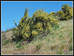 Bloomng Sagebrush |
 Trailhead Below |
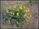 Balsamroot |
 Shadows On Ridges |
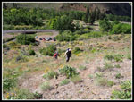
 Group Break |
 Sage & Ridge |
 Waterworks Canyon |
 Heading Up |
 Around Rocks |
 Group On The Rocks |
 Pink Wildflower |
 Penstemon |
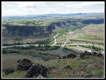 Confluence |
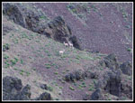 Big Horn Sheep |
 Rocky Ridge |
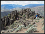 Climbing Over Wall |
 Interesting Ridge |
 David At Work |
 Lizard |
 Kim Traversing Slope |
 Faint Trail |
 Mytho-man |
 Along Rock Wall |
 Rock Formations |
 Traverse Back To Ridge |
 Lone Pine |
 Desert Parsley |
 Blooming Balsamroot |
 Beyond Rockiest Spots |
 More Wildflowers |
 Balsamroot Over Valley |
 Tiny Pink Flower |
 Balsamroot Close Up |
 Phlox |
 Plateau |
 Colorful Phlox |
 Ridge Top Color |
 Nearing False Summit |
 Towards Yakima |
 Group Summit Shot |
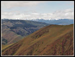 Nelson Ridge |
 Heading Higher |
 Ridge We Ascended |
 Hooker's Balsamroot |
 Heading To Saddle |
 Small Flower |
 View Of Waterworks |
 Hiding Rattlesnake |
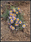 Asters |
 Descending From Saddle |
 Canyon Bottom |
 Even More Phlox |
 Bill At Work |
 Lupine |
 David & Wildflowers |
 Multi Colored Lupine |
Trips - 2014
Home