10-31-15
Most
of my trips are day hikes. Throw in some backpacking trips.
Occasionally, I'll do two short hikes in one day. After several days of
rain Saturday looked to be even heavier rain. Some flooding but since
there is no snow yet in the mountains it was not expected to be really
bad. Kim agreed to go for a hike. Our favorite hard rain hike is
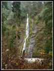
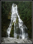
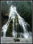
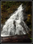
Boulder River. Feature Show Falls is only 1 1/4 miles in. Rather than
hike the entire 9 mile round trip trail we decided to hike to the falls
and then head off for another hike. We met in North Seattle at 7:30 am
and headed north. Through Arlington and east to French Creek Road. a
short distance off Highway 530 we found a small tree down across the
road. Kim's truck might have been able to drive over it. We were
concerned about more trees down after all the recent rain and wind. Kim
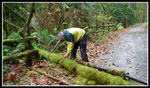
had a hand saw in her truck. I cut out the tree and we moved it and a
smaller one under it off the road.
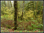
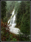
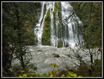
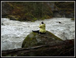
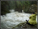
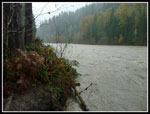
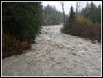
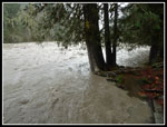
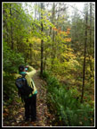
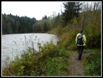
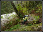
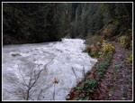
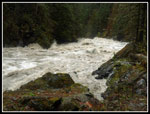
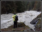
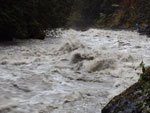
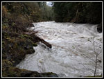
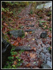
The rest of the way to the trailhead there were no more trees down. One truck passed us on the way in and was the only other vehicle at the trailhead. We already had on rain pants and added boots and jackets. The other hiker was a geology graduate student at the University of Washington. He was looking for creek and riverside rocks. This was about the worst day of the year to search. The water levels were so high that most watercourses were well above normal levels. The shores were mostly underwater. Nonetheless, he hiked to the falls. While it was raining it was not very hard. I can't recall the last time I hiked Boulder River without any rain. The falls have been very small since there was so little rain since spring. This day was way above normal.
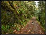
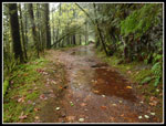
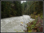
Every side creek was running. The usual small lakes on the old road section were full. Waterproof boots were worth the extra weight. We went down to the falls at the usual spot and down to the river again a little further upstream. The river was fast, deep, and loud. Worth the drive all by itself. On the way back we met several groups heading in. The rain did not keep everyone away. We discussed where else to go while we hiked. The plan was to head on to Darrington next for lunch. Kim headed for a coffee shop. As usual, she knew the folks inside. We sat down just as the power went out. Power to most or all of town. The owner called home and there was no power eight miles west of town. Well, so much for anything cooked or heated. Time to head out.
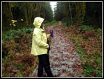
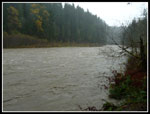
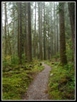
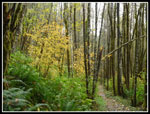
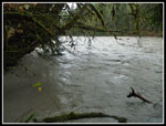
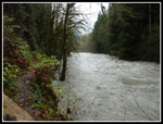
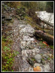
Next on the agenda was a stop at the Old Sauk Trail. There are several trailheads. We went to the second one. It is fairly new. My first visit to that trailhead but not first time on the trail. There is a 1.3 mile loop trail. A short side trail leads to the Sauk River. Deep forest with big trees and thick ground cover. A fun short loop trail. Part of it is on the longer Old Sauk Trail. At the river the level was just as high as expected. The wide riverbed is usually mostly gravel with a small river in the middle. Occasionally, the entire bed is full of water. This was one of those days. Branches, logs, and trees swept on past with hardly a gap in between. Every creek we saw all day was brown. The Sauk was as brown as I have seen it. Lots of dirt being washed downstream. While it rained much of the day it seldom was very hard. It was also warm. Quite warm for a rainy last day of October. Nobody else was on the trail while we were there. Total solitude!
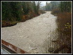
Our next stop was just a few miles farther along the Mountain Loop Highway. The big flood of 2003 took out the approach to the bridge from the highway to the boat launch near the mouth of the Whitechuck River. The channel widened and the old now too short bridge was removed and a new one put in. The campground there was mostly washed away. It is a good spot to view high water on the river. The bridge crossed the Whitechuck River. The Sauk comes in just below the boat launch. We parked just before the bridge and walked across to the boat launch. The bridge made for a great viewpoint. The river was loud just as Boulder River was earlier. We saw several other folks at the boat launch. There was no river bank. The water was nearly up to the parking lot level. A great place to feel the power of all that fast moving water. We headed back to the truck and now had one last decision to make.
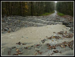
We could head back the way we came or continue on around the Mountain Loop Highway. The pavement soon ends and it is gravel on to Barlow Pass. The road might be washed out or trees might be down across it. We might make it most of the way and still have to turn around. We chose to continue on and add one more hike on the Old Robe Trail. A few miles along an SUV stopped to tell us about the washout ahead of us. I drove to the NF Sauk Trail a few years earlier and saw the remnants of a big washout that crossed the road and kept on going down to the river. Last year it washed out again. Kim and I both knew that had to be the place. The SUV crossed it and left it us to decide if we could too.
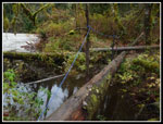
We arrived at the spot. Two creeks crossed over the road next to each other. Two vehicles came in the other direction and crossed it. We could see it was bumpy but not soft. The truck bounced right across. I would not have tried in a sedan but with enough clearance it was fine. I hope it can be repaired before more storms add to the problem. The rest of the way was fine. We went back onto pavement at Barlow Pass and headed west along the SF Stillaguamish. We cruised through Verlot and up the big hill to the trailhead. It was already 4:15 pm when we started out. Down the switchbacks and over to the river. On my last visit the water was crazy high. Way over the riverbank. This time it was high but we could get right up to the edge. The river is very wide here but narrows as you hike downstream. Soon it get very narrow in the canyon.
We continued towards the canyon. As the river narrowed it became louder. Quite a bit louder. The creek crossings were low enough to hop across. The last one has a narrow log with a rope handrail. We chose to cross on a several lower and wider logs next to it. At the start of the canyon the route is back on the old grade. Cement was used to build up the grade. in places the wooden ties were cemented into place. In one spot the wood is still there. The grade is now more than a century old. All the rocks were buried by churning water. They did manage to roil up the water even more. It was a chaotic brown river as it rushed by. Brown and loud. One woman passed us by and continued on. We stopped where a waterfall dropped down onto the grade. There is a wide spot to enjoy the river there. We wanted to get back before dark and soon began to hike back. The rain mostly held off right until we reached the trailhead. Then it began to rain. As we drove back it rained very hard soon after. Perfect timing. A stop for dinner in Granite Falls and we were on our way home.
This turned out to be a day of short hikes and a stop in Darrington. We drove all the way around the Mountain Loop and saw a number of raging rivers and waterfalls. No long hike to a lake or a mountain top but a fun day nonetheless. We expected to get rained on most of the day and we were not disappointed. While it rained, it was never as hard as we expected. This was a nice break from my usual hikes and we had a great time.
Click on thumbnails to get
larger pictures.
Trips - 2015
Home
The rest of the way to the trailhead there were no more trees down. One truck passed us on the way in and was the only other vehicle at the trailhead. We already had on rain pants and added boots and jackets. The other hiker was a geology graduate student at the University of Washington. He was looking for creek and riverside rocks. This was about the worst day of the year to search. The water levels were so high that most watercourses were well above normal levels. The shores were mostly underwater. Nonetheless, he hiked to the falls. While it was raining it was not very hard. I can't recall the last time I hiked Boulder River without any rain. The falls have been very small since there was so little rain since spring. This day was way above normal.
Every side creek was running. The usual small lakes on the old road section were full. Waterproof boots were worth the extra weight. We went down to the falls at the usual spot and down to the river again a little further upstream. The river was fast, deep, and loud. Worth the drive all by itself. On the way back we met several groups heading in. The rain did not keep everyone away. We discussed where else to go while we hiked. The plan was to head on to Darrington next for lunch. Kim headed for a coffee shop. As usual, she knew the folks inside. We sat down just as the power went out. Power to most or all of town. The owner called home and there was no power eight miles west of town. Well, so much for anything cooked or heated. Time to head out.
Next on the agenda was a stop at the Old Sauk Trail. There are several trailheads. We went to the second one. It is fairly new. My first visit to that trailhead but not first time on the trail. There is a 1.3 mile loop trail. A short side trail leads to the Sauk River. Deep forest with big trees and thick ground cover. A fun short loop trail. Part of it is on the longer Old Sauk Trail. At the river the level was just as high as expected. The wide riverbed is usually mostly gravel with a small river in the middle. Occasionally, the entire bed is full of water. This was one of those days. Branches, logs, and trees swept on past with hardly a gap in between. Every creek we saw all day was brown. The Sauk was as brown as I have seen it. Lots of dirt being washed downstream. While it rained much of the day it seldom was very hard. It was also warm. Quite warm for a rainy last day of October. Nobody else was on the trail while we were there. Total solitude!
Our next stop was just a few miles farther along the Mountain Loop Highway. The big flood of 2003 took out the approach to the bridge from the highway to the boat launch near the mouth of the Whitechuck River. The channel widened and the old now too short bridge was removed and a new one put in. The campground there was mostly washed away. It is a good spot to view high water on the river. The bridge crossed the Whitechuck River. The Sauk comes in just below the boat launch. We parked just before the bridge and walked across to the boat launch. The bridge made for a great viewpoint. The river was loud just as Boulder River was earlier. We saw several other folks at the boat launch. There was no river bank. The water was nearly up to the parking lot level. A great place to feel the power of all that fast moving water. We headed back to the truck and now had one last decision to make.
We could head back the way we came or continue on around the Mountain Loop Highway. The pavement soon ends and it is gravel on to Barlow Pass. The road might be washed out or trees might be down across it. We might make it most of the way and still have to turn around. We chose to continue on and add one more hike on the Old Robe Trail. A few miles along an SUV stopped to tell us about the washout ahead of us. I drove to the NF Sauk Trail a few years earlier and saw the remnants of a big washout that crossed the road and kept on going down to the river. Last year it washed out again. Kim and I both knew that had to be the place. The SUV crossed it and left it us to decide if we could too.
We arrived at the spot. Two creeks crossed over the road next to each other. Two vehicles came in the other direction and crossed it. We could see it was bumpy but not soft. The truck bounced right across. I would not have tried in a sedan but with enough clearance it was fine. I hope it can be repaired before more storms add to the problem. The rest of the way was fine. We went back onto pavement at Barlow Pass and headed west along the SF Stillaguamish. We cruised through Verlot and up the big hill to the trailhead. It was already 4:15 pm when we started out. Down the switchbacks and over to the river. On my last visit the water was crazy high. Way over the riverbank. This time it was high but we could get right up to the edge. The river is very wide here but narrows as you hike downstream. Soon it get very narrow in the canyon.
We continued towards the canyon. As the river narrowed it became louder. Quite a bit louder. The creek crossings were low enough to hop across. The last one has a narrow log with a rope handrail. We chose to cross on a several lower and wider logs next to it. At the start of the canyon the route is back on the old grade. Cement was used to build up the grade. in places the wooden ties were cemented into place. In one spot the wood is still there. The grade is now more than a century old. All the rocks were buried by churning water. They did manage to roil up the water even more. It was a chaotic brown river as it rushed by. Brown and loud. One woman passed us by and continued on. We stopped where a waterfall dropped down onto the grade. There is a wide spot to enjoy the river there. We wanted to get back before dark and soon began to hike back. The rain mostly held off right until we reached the trailhead. Then it began to rain. As we drove back it rained very hard soon after. Perfect timing. A stop for dinner in Granite Falls and we were on our way home.
This turned out to be a day of short hikes and a stop in Darrington. We drove all the way around the Mountain Loop and saw a number of raging rivers and waterfalls. No long hike to a lake or a mountain top but a fun day nonetheless. We expected to get rained on most of the day and we were not disappointed. While it rained, it was never as hard as we expected. This was a nice break from my usual hikes and we had a great time.
 Sawyer Jim |
 Start Of Boulder River |
 Green Wall |
 Big Puddles |
 First Waterfall |
 Big Falls Coming Up |
 Feature Show Falls |
 Bottom Of Falls |
 Kim By The River |
 Roaring Boulder River |
 Falls From River |
 Old Sauk Trailhead |
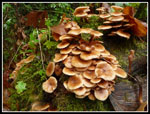 Multiple Mushrooms |
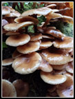 Shrooms Close Up |
 Kim And Coffee |
 Wide Sauk River |
 Looking Down River |
 Forest Walk |
 Creek Hits Bridge |
 Whitechuck River |
 Whitechuck From Bridge |
 River At Boat Launch |
 Mt. Loop Washout |
 Old Robe Color |
 Kim & Leaves |
 Good Color |
 Trail To River |
 SF Stillaguamish |
 Trail Along River |
 Climbing Over Log |
 Entering Canyon |
 Along RR Grade |
 Getting Better |
 Turnaround Point |
 Kim By River |
 Boiling River |
 Looking Up River |
 Falls Onto Grade |
 Raining Rocks |
 Railroad Grade |
 Very Old RR Ties |
 Slick Bridge |
Trips - 2015
Home