2-16-15
Last
spring Gwen and I hiked up Mt.
Townsend in mid April. Very
early to reach the 6300' summit. Very early
to have reached the parking lot. With recent reports of folks hiking up
in February we decided to head on over. Last year we had 360 degree
views of clouds. This day was forecast to be all blue sky. We took the
7:10 am ferry to Kingston. From there over the Hood Canal Bridge and on
to Quilcene. Gwen had checked with Jay Thompson about a different route
up. All my previous trips were via the trail from Townsend Creek.
Another route is the Little Quilcene Trail. It is shorter and starts
higher at 4000'. Could we drive to 4000' without snow in mid February?
We decided to give it a try. Jay also said he would meet us on the
trail.
We drove up to Bon Ton Pass. The road is in excellent condition. Hardly any pot holes. The road to our trailhead was a bit worse but still not too bad. Easy in a Subaru. We arrived at the road end trailhead just before 9:00 am to find two cars already there. There was not a drop of snow to be seen. The summit of Mt. Townsend was right above us. There was a little snow up there. Lots of rhododendrons at the trailhead and on the first part of the trail. Buds are in place. They will be flowering way before July. It was sunny and 39 degrees with a cold breeze at the trailhead. Once on the way the wind was minimal. We got started at 9:20 am.
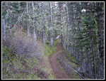
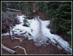
The trail is in great shape. Just a few small trees down and none were a problem. The route gains elevation quickly which allowed us to warm up. There is a creek near the bottom then no more water the rest of the way. The grade flattens after reaching the top of the ridge after 850' of elevation gain. Now the way drops a little and makes a slow climbing traverse. I thought there might be some icy snow on this northern aspect at 5000' and above. There was none. Just a nice spring day on bare dirt in February. As we hiked through Sleepy Hollow Jay caught up with us. A few minutes later we reached the junction with the Dirty Face Ridge Trail. That route drops steeply to a trailhead accessed from near Sequim.
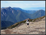
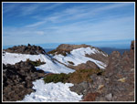
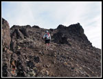
We did have a few short icy spots just before the junction. We had a few more just after it. While they were very slick they were also very short. The longest one was about 30' long. Then it was back to bare trail once again. At about 5500' the forest thinned and views really began. Down to the Strait of Juan De Fuca and up to peaks around us. We continued up with a rising traverse then switchbacks. We came to an unsigned junction. A piece of wood mounted on a tree suggests there was a sign at one time. Right is the direct route to the real summit. Left is a trail to the ridge top. Form there it is up the rocky ridge to the old summit that held a fire lookout the on to the real summit. We chose to go left. We had very nice views from where we reached the ridge top.
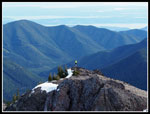
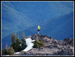
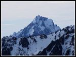
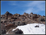
There was snow on the left side of the ridge but none on top. From the first summit we dropped a little, met up with the other trail and then climbed to the real summit. There were several groups there already. We met two guys coming down earlier who had camped on top. We met the owners of the other car at our trailhead on the summit. There was a steady swirling breeze that made it quite cold. I put on a jacket immediately. Soon I added my puffy layer. The promised blue sky was actually part white and part blue. Views were clear but we did not get the white snow against blue sky in several directions. Still, the views were infinitely better than last spring.
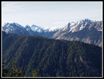
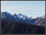
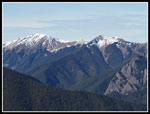
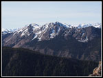
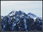
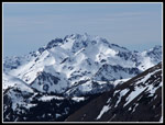
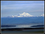
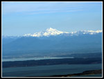
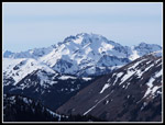
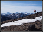
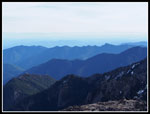
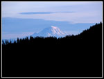
A steady stream of folks came up and down. Nearly all came via the usual trail. Some folks mentioned using microspikes on the upper trail. we carried them but did not come close to using them on our route. We arrived at 12:00 pm and stayed for a full two hours. We could see all the volcanoes in Washington. Baker, Glacier Peak, Rainier, Adams, and St. Helens. With my zoom lens I was able to see downtown Seattle. A little hazy but clear enough. With Hood Canal, Liberty Bay, Dyes Inlet, and Port Orchard (the waterway) there were numerous land - water layers laid out below us. Jay helped name the Olympic Peaks. I don't see them often enough to have memorized very many. The higher ones did have snow and did look at least a little winter like. Constance, Buckhorn, Mystery, Fribaca, Baldy, Deception, and more were laid out around us.
Jay had business back home and he left first. At 2:00 pm Gwen and I packed up and headed down. We met another group at the other summit and got to talking. At about 2:25 pm we did leave the summit area. The hike down was much faster. The trail is very smooth. In about 1.5 hours we were back at the car. It is about 7 miles round trip with about 2500' of total elevation gain. We could see four cars in the lot from the summit and the other three were gone at 4:00 pm.
Though Presidents Day is not a major three day weekend we did have a one ferry wait in Kingston. Mt. Townsend is a great spring and early summer hike with great views. It is not supposed to be a bare dirt hike in February. Still, we were able to take advantage of the strange weather to enjoy a great hike to a terrific summit on a sunny winter day.
Click
on thumbnails to get larger pictures.
Trips - 2015
Home
We drove up to Bon Ton Pass. The road is in excellent condition. Hardly any pot holes. The road to our trailhead was a bit worse but still not too bad. Easy in a Subaru. We arrived at the road end trailhead just before 9:00 am to find two cars already there. There was not a drop of snow to be seen. The summit of Mt. Townsend was right above us. There was a little snow up there. Lots of rhododendrons at the trailhead and on the first part of the trail. Buds are in place. They will be flowering way before July. It was sunny and 39 degrees with a cold breeze at the trailhead. Once on the way the wind was minimal. We got started at 9:20 am.
The trail is in great shape. Just a few small trees down and none were a problem. The route gains elevation quickly which allowed us to warm up. There is a creek near the bottom then no more water the rest of the way. The grade flattens after reaching the top of the ridge after 850' of elevation gain. Now the way drops a little and makes a slow climbing traverse. I thought there might be some icy snow on this northern aspect at 5000' and above. There was none. Just a nice spring day on bare dirt in February. As we hiked through Sleepy Hollow Jay caught up with us. A few minutes later we reached the junction with the Dirty Face Ridge Trail. That route drops steeply to a trailhead accessed from near Sequim.
We did have a few short icy spots just before the junction. We had a few more just after it. While they were very slick they were also very short. The longest one was about 30' long. Then it was back to bare trail once again. At about 5500' the forest thinned and views really began. Down to the Strait of Juan De Fuca and up to peaks around us. We continued up with a rising traverse then switchbacks. We came to an unsigned junction. A piece of wood mounted on a tree suggests there was a sign at one time. Right is the direct route to the real summit. Left is a trail to the ridge top. Form there it is up the rocky ridge to the old summit that held a fire lookout the on to the real summit. We chose to go left. We had very nice views from where we reached the ridge top.
There was snow on the left side of the ridge but none on top. From the first summit we dropped a little, met up with the other trail and then climbed to the real summit. There were several groups there already. We met two guys coming down earlier who had camped on top. We met the owners of the other car at our trailhead on the summit. There was a steady swirling breeze that made it quite cold. I put on a jacket immediately. Soon I added my puffy layer. The promised blue sky was actually part white and part blue. Views were clear but we did not get the white snow against blue sky in several directions. Still, the views were infinitely better than last spring.
A steady stream of folks came up and down. Nearly all came via the usual trail. Some folks mentioned using microspikes on the upper trail. we carried them but did not come close to using them on our route. We arrived at 12:00 pm and stayed for a full two hours. We could see all the volcanoes in Washington. Baker, Glacier Peak, Rainier, Adams, and St. Helens. With my zoom lens I was able to see downtown Seattle. A little hazy but clear enough. With Hood Canal, Liberty Bay, Dyes Inlet, and Port Orchard (the waterway) there were numerous land - water layers laid out below us. Jay helped name the Olympic Peaks. I don't see them often enough to have memorized very many. The higher ones did have snow and did look at least a little winter like. Constance, Buckhorn, Mystery, Fribaca, Baldy, Deception, and more were laid out around us.
Jay had business back home and he left first. At 2:00 pm Gwen and I packed up and headed down. We met another group at the other summit and got to talking. At about 2:25 pm we did leave the summit area. The hike down was much faster. The trail is very smooth. In about 1.5 hours we were back at the car. It is about 7 miles round trip with about 2500' of total elevation gain. We could see four cars in the lot from the summit and the other three were gone at 4:00 pm.
Though Presidents Day is not a major three day weekend we did have a one ferry wait in Kingston. Mt. Townsend is a great spring and early summer hike with great views. It is not supposed to be a bare dirt hike in February. Still, we were able to take advantage of the strange weather to enjoy a great hike to a terrific summit on a sunny winter day.
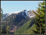 Summit From Trailhead |
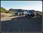 Parking Area |
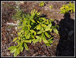 Rhododendrons |
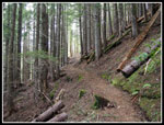 Open Forest |
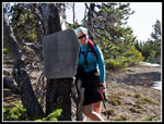
 Little Quilcene Trail |
 Mountain Views |
 Olympic Mountain Peaks |
 Not Much Snow |
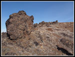 Pillow Lava |
 Jay Thompson |
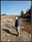
 Gwen & Wilderness |
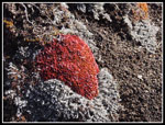 Winter Color |
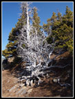 Silver Snag |
 Great Views |
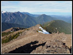 Looking Down Ridge |
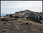 Summit In Sight |
 Gwen Nears Summit |
 Snowy Peak |
 Mystery & Fribaca |
 Gwen On Point |
 Close Up |
 Mt. Baker |
 Glacier Peak |
 Changing Lighting |
 Mt. Constance |
 Looking To Other Summit |
 Townsend Summit |
 Hiker Heading Down |
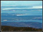 Port Townsend |
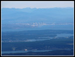 Downtown Seattle |
 Ridges |
 Heading Down |
 Gwen Descending |
 Largest Snow Patch |
 Mt. Rainier |
Trips - 2015
Home