4-26-15
Umtanum
Ridge is an old favorite
hike of mine. My first visit was on 4-13-91. Almost exactly 24 years
ago. Back then I went in via the Durr Road. Down a muddy dirt road to
Umtanum Creek and through the creek in my Plymouth Horizon with tiny
13" wheels. It was always an adventure. I made several more visits
before I discovered access via Umtanum Creek from the Yakima River. My
first time there was in 1997. We hiked up the first canyon on the south
side. Higher up that canyon we switchbacked to the left and the old
road curled around the ridge
until we were right above the Yakima River. We also took a minimal boot
path to the right at the junction, across the tiny creek, and up to an
open grassy
meadow. The boot path continued a little further before disappearing.
The ridge top could be seen high above. I came back on 5-28-00 and
followed the boot path until it ended. I continued higher and higher
all the way to the ridge top. There was no trail. With the much easier
drive, this became my preferred route up to the ridge top. I
returned in 2003,
2004,
2005,
and 2006.
It became a real favorite spring wildflower hike. I wanted to go back
this year and was amazed to see that it had been nine years since my
last visit.
On my previous visit a thin boot path was appearing. It went up to where an old barbed wire fence partly stood. From there it gets very steep to the ridge top. Very little path existed. I headed out of Seattle at 6:35 am and made a short gas stop in Cle Elum. I headed south of Ellensburg down Canyon Road to the Umtanum Recreation Area parking lot. The $5.00 parking fee starts on 5-15. I arrived at the 1340' trailhead at 8:45 am. A few minutes later I was heading for the bridge. This hike starts by crossing the Yakima River on a suspension bridge. It was chilly but clear and was warming rapidly. Under the railroad tracks and immediately I reached the junction. Left goes up the valley. Right is the way tot he ridge top.
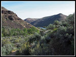
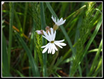
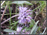
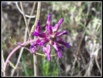
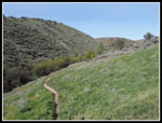
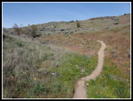
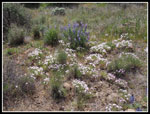
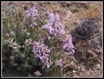
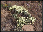
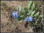
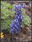
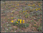
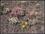
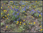
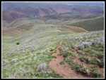
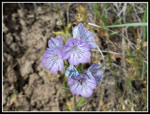
Blooming wildflowers began here and never let up. Lomatium and phlox especially. The phlox continued from valley to ridge top. It ranged from white to deep pink in color. The trail climbs up that first canyon on an old road. I soon saw larkspur and balsamroot. There were bunches of woodland stars. Death camas are blooming. The canyon was shaded from the early morning sun and the lack of glare helped with photos. There were more flowers whose names I do not know. Lots of yellow especially. High up the canyon the trail crosses what little creek there is in late April and splits. The major route I took in 1997 that switches back and goes around to just above the Yakima River is now the minor trail. The minimal boot path back then is now the obvious trail on the right. That is the only junction. The boot path is much wider than nine years ago. Before I had to push through brush in places and be very vary of ticks. Now the trail is wide enough to avoid the brush.
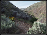
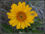
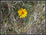
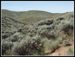
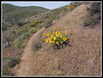
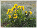
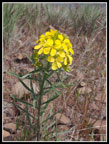
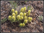
The bitterbrush (what I used to think was sagebrush) has leafed out and is starting to bloom. Once out of that first canyon I was in the sunshine and would remain there for the rest of the hike. There really is no shade on this hike. One more reason I do not hike it in the summer. With all my photo stops I was making slow progress. I expected a steady stream of folks passing me. That did not occur. I had the whole place to myself for most of the day. Very strange when the wildflowers are peaking. I passed many more balsamroot plants and now lupine too. There were many pale blue trumpet like flowers. I'm not sure of the name. Some Hooker's balsamroot appeared. They have just one big yellow flower compared to the many flowers in a bunch with the arrowleaf variety.
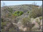
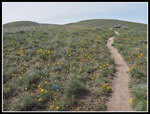
The trail climbs up onto a wide rounded side ridge. Now it points straight up to the ridge top. Forget about switchbacks. Right up the fall line. I reached the old barbed wire fence. It is brushy here but the trail continues without touching any of it. As I headed up the steepest stretch the trail continues. The unmarked slope of my first visit gave way to a boot path and now it is a trail all the way up. More wildflowers added to lots of the ones I had already seen. I was especially surprised to see some shooting stars. They are usually seen near creeks. The slope was very dry.
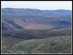
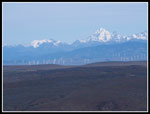
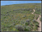
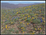
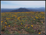
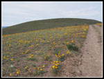
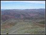
The climb relented and a few minutes later I was on the ridge top. It was only 2.5 miles with 2100' of gain to the 3440' old road on the ridge top. Even on my most recent visit I laid rocks across the road to find the spot to head back down. Now the dirt trail makes it obvious. There was also a rock cairn marking the spot. I had a quick break then headed left. Wildflowers dotted or covered both sides of the road. In the distance I could see Mt. Stuart and the Stuart Range. Below them were power generating windmills that were not there on previous visits. The top of Mt. Adams was in the clouds. Soon I could see the bottom of Mt. Rainier. No volcanoes were in the clear. The road goes up and down with more down than up. Some stretches had thick carpets of balsamroot. Others had few blooming flowers.
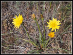
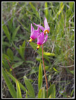
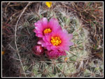
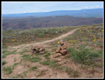
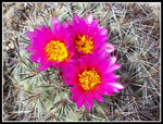
The first thing I noticed on the ridge top were the blooming hedgehog cacti. Lots of them. I recalled a few patches on previous visits but this time there were many of them. The fluorescent pink color is unique. I found bluebells, ballhead waterleaf, and a number of other flowers on top. I continued another 2.5 miles down the ridge. I stopped before the final drop to Roza Creek. I had seen a trip report from one day earlier which showed the flowers I had already seen. The one I could not find was bitterroot. I've seen it before here but try as I might I could not find any trace of it. That was the lone disappointment this day.
Heading back I had one 350' climb and several smaller ones. I took one side trip to where I had seen bitterroot other years. None this day. I took one final break back where the trail met the road. Starting down I ran into a family just below the ridge. The first people I saw in 7.5 miles and 4 1/2 hours. So much for me fear of crowds on the route. I saw another 6 or 7 groups coming up as I headed down. I took two hours to reach the ridge. It only took about 1:18 to come down. I took a lot less photos on the descent as well. It was much warmer and I was glad to be going down and not up. I reached the bridge at 2:45 pm. Plenty early to get back to Seattle by early evening.
I'm still amazed that nine years slipped by between visits to Umtanum Ridge. I did hike a number of new trails east of the crest looking for wildflower in between visits. I missed the bitterroots but my timing was nearly perfect for most of the other wildflowers. Somehow I even had a whole lot of solitude. Well worth 240 miles of driving on a sunny spring day.
Click on thumbnails to get
larger pictures.
Trips - 2015
Home
On my previous visit a thin boot path was appearing. It went up to where an old barbed wire fence partly stood. From there it gets very steep to the ridge top. Very little path existed. I headed out of Seattle at 6:35 am and made a short gas stop in Cle Elum. I headed south of Ellensburg down Canyon Road to the Umtanum Recreation Area parking lot. The $5.00 parking fee starts on 5-15. I arrived at the 1340' trailhead at 8:45 am. A few minutes later I was heading for the bridge. This hike starts by crossing the Yakima River on a suspension bridge. It was chilly but clear and was warming rapidly. Under the railroad tracks and immediately I reached the junction. Left goes up the valley. Right is the way tot he ridge top.
Blooming wildflowers began here and never let up. Lomatium and phlox especially. The phlox continued from valley to ridge top. It ranged from white to deep pink in color. The trail climbs up that first canyon on an old road. I soon saw larkspur and balsamroot. There were bunches of woodland stars. Death camas are blooming. The canyon was shaded from the early morning sun and the lack of glare helped with photos. There were more flowers whose names I do not know. Lots of yellow especially. High up the canyon the trail crosses what little creek there is in late April and splits. The major route I took in 1997 that switches back and goes around to just above the Yakima River is now the minor trail. The minimal boot path back then is now the obvious trail on the right. That is the only junction. The boot path is much wider than nine years ago. Before I had to push through brush in places and be very vary of ticks. Now the trail is wide enough to avoid the brush.
The bitterbrush (what I used to think was sagebrush) has leafed out and is starting to bloom. Once out of that first canyon I was in the sunshine and would remain there for the rest of the hike. There really is no shade on this hike. One more reason I do not hike it in the summer. With all my photo stops I was making slow progress. I expected a steady stream of folks passing me. That did not occur. I had the whole place to myself for most of the day. Very strange when the wildflowers are peaking. I passed many more balsamroot plants and now lupine too. There were many pale blue trumpet like flowers. I'm not sure of the name. Some Hooker's balsamroot appeared. They have just one big yellow flower compared to the many flowers in a bunch with the arrowleaf variety.
The trail climbs up onto a wide rounded side ridge. Now it points straight up to the ridge top. Forget about switchbacks. Right up the fall line. I reached the old barbed wire fence. It is brushy here but the trail continues without touching any of it. As I headed up the steepest stretch the trail continues. The unmarked slope of my first visit gave way to a boot path and now it is a trail all the way up. More wildflowers added to lots of the ones I had already seen. I was especially surprised to see some shooting stars. They are usually seen near creeks. The slope was very dry.
The climb relented and a few minutes later I was on the ridge top. It was only 2.5 miles with 2100' of gain to the 3440' old road on the ridge top. Even on my most recent visit I laid rocks across the road to find the spot to head back down. Now the dirt trail makes it obvious. There was also a rock cairn marking the spot. I had a quick break then headed left. Wildflowers dotted or covered both sides of the road. In the distance I could see Mt. Stuart and the Stuart Range. Below them were power generating windmills that were not there on previous visits. The top of Mt. Adams was in the clouds. Soon I could see the bottom of Mt. Rainier. No volcanoes were in the clear. The road goes up and down with more down than up. Some stretches had thick carpets of balsamroot. Others had few blooming flowers.
The first thing I noticed on the ridge top were the blooming hedgehog cacti. Lots of them. I recalled a few patches on previous visits but this time there were many of them. The fluorescent pink color is unique. I found bluebells, ballhead waterleaf, and a number of other flowers on top. I continued another 2.5 miles down the ridge. I stopped before the final drop to Roza Creek. I had seen a trip report from one day earlier which showed the flowers I had already seen. The one I could not find was bitterroot. I've seen it before here but try as I might I could not find any trace of it. That was the lone disappointment this day.
Heading back I had one 350' climb and several smaller ones. I took one side trip to where I had seen bitterroot other years. None this day. I took one final break back where the trail met the road. Starting down I ran into a family just below the ridge. The first people I saw in 7.5 miles and 4 1/2 hours. So much for me fear of crowds on the route. I saw another 6 or 7 groups coming up as I headed down. I took two hours to reach the ridge. It only took about 1:18 to come down. I took a lot less photos on the descent as well. It was much warmer and I was glad to be going down and not up. I reached the bridge at 2:45 pm. Plenty early to get back to Seattle by early evening.
I'm still amazed that nine years slipped by between visits to Umtanum Ridge. I did hike a number of new trails east of the crest looking for wildflower in between visits. I missed the bitterroots but my timing was nearly perfect for most of the other wildflowers. Somehow I even had a whole lot of solitude. Well worth 240 miles of driving on a sunny spring day.
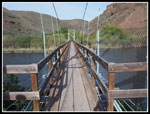 Suspension Bridge |
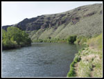 Yakima River |
 Umtanum Creek |
 Death Camas |
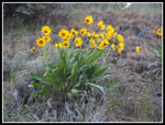 Arrowleaf Balsamroot |
 Woodland Star |
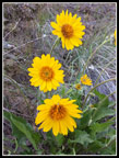 Triple Balsamroot |
 Ballhead Waterleaf |
 Small Flower |
 Ascending Canyon |
 Lone Balsamroot |
 Near Junction |
 Meadow |
 Hookers Balsamroot |
 Climbing Side Ridge |
 Bitterbrush |
 Phlox |
 More Balsamroot |
 Depression |
 More Yellow |
 Penstemon |
 Many Flowers |
 Top Of Side Ridge |
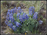 Lupine |
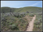 Old Fence |
 Stuart & Ingalls |
 Nearing Ridge Top |
 Shooting Stars |
 Bluebells |
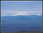 Mt. Adams |
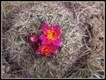 Hedgehog Cactus |
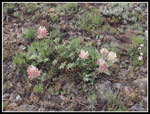 Big Head Clover |
 Blooming Lupine |
 Backlit Balsamroot |
 Littered With Color |
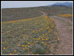 Lined With Color |
 Wildflower Carpet |
 Closer |
 Looking East |
 Wallflower |
 Desert Color |
 Paintbrush Like |
 Heading Back |
 Blue & Yellow |
 Trail Down |
 Closest |
 Looking Down |
 Top Is Steep |
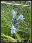 Large-Flowered Brodiaea |
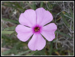 Pink Phlox |
 Pale Flower |
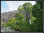 Aspen? |
Trips - 2015
Home