7-01-18
Kim
was free for a hike. I did a 12 mile hike the day before with 240 miles
of driving. Something a little easier sounded good. Unfortunately it
would be raining west of the Cascades and in the Cascades. Farther east
it would be drier but very windy. What to do? We chose to head east and
try to outsmart the wind. Another day with a long drive but Kim would
be doing the driving. With a shorter hike planned I had an extra hour
of sleep. we met in North Seattle at 7:00 am. East to Cle Elum then
north on Highway 970 to Highway 97. We drove to just past Mineral
Springs Resort and turned left. 2.6 miles of pretty good gravel road
brought us to a junction. We turned left heading towards Red Top. The
road goes to the ridge top right below the lookout. That leaves a very
short hike to the top. We chose to go .50 miles on the road to the
trailhead for the Blue Creek Trail. Kim had done the hike several times
but I had never done it.
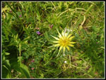
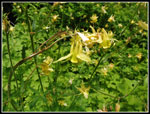
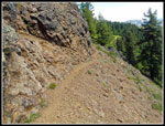
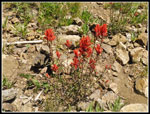
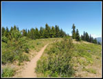
We arrived at 9:10 am. By 9:20 am we were ready to hit the trail. The start is pretty steep before the route begins to switchback higher. It is only 2 miles to the summit but it gains about 1650'. About half the distance and elevation gain as Mt. Si. There are many wildflowers along the trail. This late they were mostly past prime lower down. The higher we went the better they became. At the ridge top there are many flowers still in bloom. Indian paintbrush showed up first. In open rocky areas we saw a lot of bright stonecrop flowers. Some meadows of tiger lilies soon appeared. Some of the lower trail had lots of logging stumps but we also saw some impressively big trees too. Quite a variety of fir and pine trees. The trail is in good shape. It is narrow in places but the tread is fine. There are only a few spots with any brush.
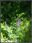
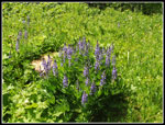
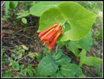
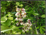
There were many peas in bloom. Maybe more than I have ever seen. There were a few flowers I see only rarely, like salsify. A friend had done the short trail to the summit a few days earlier. She photographed a flower I do not recall seeing. Then there it was, right along the trail. It turned out to be western coneflower. Atop the stalk and leaves is a black cone shaped pod. A meadow contained a creek and lots of green plants. Lupine began to appear. Kim pointed out the remains of an old cabin right next to the trail. It seems to have collapsed, probably under a snow load. At about 1.85 miles we reached the junction with the Teanaway Ridge Trail. We were now on the forested ridge.
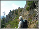
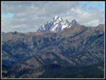
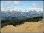
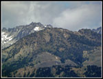
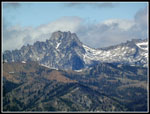
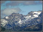
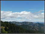
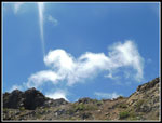
The wind was blowing hard but the thick forest blocked much of it. Since the forecast called for gusts up to 30 mph at this elevation I planned to avoid the west wind by hiking up the east side of the mountain. It worked very well. Now on the ridge we were in the wind. Our trail crossed the Teanaway Ridge Trail and rose to the left as the ridge climbed to the summit of Red Top Mountain. We quickly moved back to the east side below the ridge. The trail here is narrow where it was cut from the very steep rock slope. I would not hike it if exposed to 30 mph winds. We had complete calm. An open traverse then a switchback up to the ridge top. The wind was awaiting us. Clouds covered the Cascade Crest but peaks on the east side were mostly in the clear. Even Mt. Stuart was in the clear.
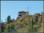
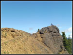
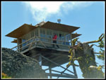
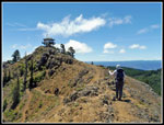
It just took a few minutes to reach the lookout. A volunteer host was in the lookout and offered us a chance to climb up. Great views from the lookout. I have been up once snow free a quarter century ago and three times on snowshoes in winter. The lookout was closed up each time. The walkway provided a spectacular viewpoint though the wind on the west side was very strong. We were pretty quickly ushered out of the building and descended to the ridge top. There is a rock wall that blocked all the wind. We sat down on the east side of it and had lunch with views east and no wind. It was now 12:00 pm and time for lunch.
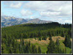
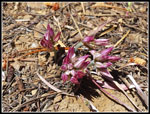
We had a half hour break then packed up to go. We noticed that on the windward side the bare rock had a number of blooming bitterroot. Getting a photo in the wind was not easy. I managed to get one that was not blurry. We soon headed off the ridge. A few seconds later the wind was gone. Since it was only 2 miles to the top I hoped that we could continue north on the Teanaway Ridge Trail. The amount of wind would decide. We dropped back to the trails junction and headed north. The ridge is mostly open to the east but heavily forested to the west. The trees managed to minimize most of the wind. We were in good shape to continue. The ridge is well known for agates and geodes. This day there were a number of folks digging for them.
Unlike many ridges this one is pretty flat. The trail continues to Iron Bear Pass and beyond. I have hikes much of it. I had not been far beyond the lookout at this end of the ridge. Along the way we found many more wildflowers and one western tanager bird. Kim noticed several small wild onions near the trail. We went about a mile until the trail drops off the ridge to the east losing about 300' in a series of switchbacks. That was far enough for us. We headed back. In places the ridge was in forest and in places there were views to the east. It was nice to be out in the sunshine. It was not all that hot but it was very comfortable. At about 5280' the ridge is a mile high and about 100' below the lookout elevation. Closer to the lookout there is a great view of the tower. It appears to be atop a vertical rock. Quite a sight.
We dropped down to the trail junction then down the Blue Creek Trail. Descending was much faster. We made good time. We saw nobody on the Blue Creek Trail on the way up and again on the way down. There were bugs on the upper trail that were a nuicence going up. They were less of a problem at a faster pace going down. By 4:20 pm we were back at the car. This was a great short hike. We hiked 6 miles round trip with about 1900' of elevation gain. The Blue Creek Trail was in fine shape. The wildflower show improved as we ascended. The lookout was open and the sky was mostly clear. We had terrific views. We saw some folks on the ridge top and summit but had complete solitude going up and down. I was able to add my second new trail in one weekend. All in all, it was a whole lot of fun.
Click on thumbnails to get
larger pictures.
Trips - 2018
Home
We arrived at 9:10 am. By 9:20 am we were ready to hit the trail. The start is pretty steep before the route begins to switchback higher. It is only 2 miles to the summit but it gains about 1650'. About half the distance and elevation gain as Mt. Si. There are many wildflowers along the trail. This late they were mostly past prime lower down. The higher we went the better they became. At the ridge top there are many flowers still in bloom. Indian paintbrush showed up first. In open rocky areas we saw a lot of bright stonecrop flowers. Some meadows of tiger lilies soon appeared. Some of the lower trail had lots of logging stumps but we also saw some impressively big trees too. Quite a variety of fir and pine trees. The trail is in good shape. It is narrow in places but the tread is fine. There are only a few spots with any brush.
There were many peas in bloom. Maybe more than I have ever seen. There were a few flowers I see only rarely, like salsify. A friend had done the short trail to the summit a few days earlier. She photographed a flower I do not recall seeing. Then there it was, right along the trail. It turned out to be western coneflower. Atop the stalk and leaves is a black cone shaped pod. A meadow contained a creek and lots of green plants. Lupine began to appear. Kim pointed out the remains of an old cabin right next to the trail. It seems to have collapsed, probably under a snow load. At about 1.85 miles we reached the junction with the Teanaway Ridge Trail. We were now on the forested ridge.
The wind was blowing hard but the thick forest blocked much of it. Since the forecast called for gusts up to 30 mph at this elevation I planned to avoid the west wind by hiking up the east side of the mountain. It worked very well. Now on the ridge we were in the wind. Our trail crossed the Teanaway Ridge Trail and rose to the left as the ridge climbed to the summit of Red Top Mountain. We quickly moved back to the east side below the ridge. The trail here is narrow where it was cut from the very steep rock slope. I would not hike it if exposed to 30 mph winds. We had complete calm. An open traverse then a switchback up to the ridge top. The wind was awaiting us. Clouds covered the Cascade Crest but peaks on the east side were mostly in the clear. Even Mt. Stuart was in the clear.
It just took a few minutes to reach the lookout. A volunteer host was in the lookout and offered us a chance to climb up. Great views from the lookout. I have been up once snow free a quarter century ago and three times on snowshoes in winter. The lookout was closed up each time. The walkway provided a spectacular viewpoint though the wind on the west side was very strong. We were pretty quickly ushered out of the building and descended to the ridge top. There is a rock wall that blocked all the wind. We sat down on the east side of it and had lunch with views east and no wind. It was now 12:00 pm and time for lunch.
We had a half hour break then packed up to go. We noticed that on the windward side the bare rock had a number of blooming bitterroot. Getting a photo in the wind was not easy. I managed to get one that was not blurry. We soon headed off the ridge. A few seconds later the wind was gone. Since it was only 2 miles to the top I hoped that we could continue north on the Teanaway Ridge Trail. The amount of wind would decide. We dropped back to the trails junction and headed north. The ridge is mostly open to the east but heavily forested to the west. The trees managed to minimize most of the wind. We were in good shape to continue. The ridge is well known for agates and geodes. This day there were a number of folks digging for them.
Unlike many ridges this one is pretty flat. The trail continues to Iron Bear Pass and beyond. I have hikes much of it. I had not been far beyond the lookout at this end of the ridge. Along the way we found many more wildflowers and one western tanager bird. Kim noticed several small wild onions near the trail. We went about a mile until the trail drops off the ridge to the east losing about 300' in a series of switchbacks. That was far enough for us. We headed back. In places the ridge was in forest and in places there were views to the east. It was nice to be out in the sunshine. It was not all that hot but it was very comfortable. At about 5280' the ridge is a mile high and about 100' below the lookout elevation. Closer to the lookout there is a great view of the tower. It appears to be atop a vertical rock. Quite a sight.
We dropped down to the trail junction then down the Blue Creek Trail. Descending was much faster. We made good time. We saw nobody on the Blue Creek Trail on the way up and again on the way down. There were bugs on the upper trail that were a nuicence going up. They were less of a problem at a faster pace going down. By 4:20 pm we were back at the car. This was a great short hike. We hiked 6 miles round trip with about 1900' of elevation gain. The Blue Creek Trail was in fine shape. The wildflower show improved as we ascended. The lookout was open and the sky was mostly clear. We had terrific views. We saw some folks on the ridge top and summit but had complete solitude going up and down. I was able to add my second new trail in one weekend. All in all, it was a whole lot of fun.
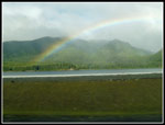 Rainbow |
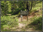 Blue Creek Trailhead |
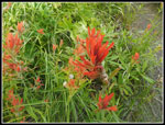 Indian Paintbrush |
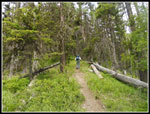 Kim On Trail |
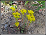 Stonecrop |
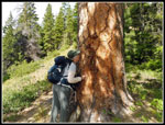 Tree Kisser |
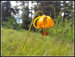 Tiger Lily |
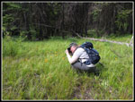 Kim At Work |
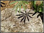
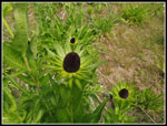 Western Coneflower |
 Salsify |
 First Lupine |
 Big Lupine Patch |
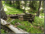 Cabin Remains |
 Yellow Columbine |
 Lookout In Sight |
 Red Top Lookout |
 Narrow Trail |
 Folks On Rock |
 Mt. Stuart |
 Lookout Close Up |
 Stuart Range |
 Teanaway Ridge Trail |
 Three Brothers |
 Argonaut Peak |
 Colchuck & Dragontail |
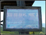 Lookout Info |
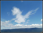
 Cloud Formations |
 A Chicken? |
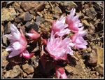 Bitterroot |
 Kim & Lookout |
 More Clouds |
 Red Top Summit |
 More Paintbrush |
 Shadow |
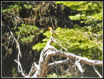 Western Tanager |
 Onion |
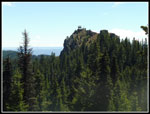 Impressive Summit |
 Open Ridge Walking |
 Honeysuckle |
 White Flower |
Trips - 2018
Home