3-17-18
Gwen
was free for a hike. We chose
a trip up north by Bellingham. She had not been on the Rock Trail and I
wanted a new route that included it. I put together a hike to Fragrance
Lake and a loop over the Cyrus Gates Lookout and down the rock trail.
Me met in North Seattle at 7:00 am and headed north. Up past Burlington
and then on Chuckanut Drive. The trailhead is a mile up Cleator Road.
We headed up the road and found... a blocked road. The guys there
explained that this was the day of the Chuckanut 50 km run. 500 runners
were signed up. They were running on our route. This was not going to
work. Time to fall back on Plan 2. Except there was no Plan 2. What to
do? We discussed a couple other trails seen the night before online.
Time to head for Whatcom Falls Park then figure out where else to go.
It is a
small park along Whatcom Creek to the shore of Whatcom Lake. We headed
north arriving at the park at 8:55 am. A few minutes later we were on
our way.
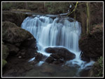
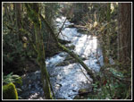
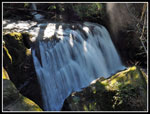
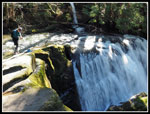
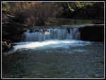
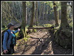
Immediately we reached the Stone Bridge, built by the CCC in 1939. It crosses Whatcom Creek just downstream of Whatcom Falls. The falls are quite impressive. Not that tall but plenty wide. Well, 100' into the trip we had already seen the falls. We managed to hike most of the trails in the park. The park is narrow encompassing both sides of the creek from Lake Whatcom down to Woburn Street. We turned downstream at first. There were a number of folks in the park but it was not crowded. The creek is in a forested gorge. It is full of white water and the sound of rushing water. A section of the trail is an off leash dog park. Lots of dogs on the trail. Gwen had to visit each one. The owners were happy to comply. Nearing Woburn Street and the end of the park we found an entrance into the Bayview Cemetery. Fascinating bits of history here. In just the section we walked one person's death dated to 1909. Our original planned hike goes to the Cyrus Gates Overlook. Gwen found the headstone for Cyrus Gates. His history is important to early days in the Bellingham area.
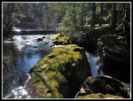
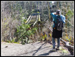
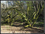
We continued on to a trail along the top of the gorge of Whatcom Creek. It was along this part of the creek that a pipeline explosion in 1999 killed three people and burned a good chunk of the area along the creek. These parts are still off limits as it heals. A wet spot along here provided our first look at nice yellow skunk cabbage. Gwen would say bog lanterns. I did not expect them to be flowering yet. We completed a loop and followed the main trail back across the (water) Pipeline Bridge and back to where we started. We continued on towards Lake Whatcom. We scoped out another falls and a series of small and large trails. Some trails go off to nearby neighborhoods. A big surprise was a short spur trail to the remains of an old wooden railroad trestle. A part of it is gone leaving a gap. Rails still sit atop the trestle. There are not many like it around anymore. Research shows it was built in 1916 to move lumber from the Larson Mill to Bellingham Bay.
We reached the end and crossed Electric Avenue to Bloedel Donovan Park on the shore of Lake Whatcom. A sunny day by the lake for lunch is not so bad. After a long break we headed back. This time we stayed on this side of the creek. This took us by the other side of the railroad trestle. It is high above the ground. No connection on this end either. The path took us back to the fish hatchery next to the parking lot. It was 12:20 by the time we reached the car. We took almost 3.5 hours to hike just under five miles. A pace conducive to enjoying the park rather than racking up miles. Now we headed off for hike number two.
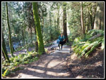
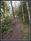
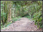
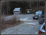
Before settling on the Fragrance Lake - Rock Trail trip we discussed several other trails near Bellingham. One was the Lookout Forest Forest Preserve. This 4430 acre preserve is administered by the Whatcom County Parks and Recreation Department. Here is a link to information on the preserve. It is located just west of Lake Whatcom and east of I-5. The forest preserve is very new. It currently has 6 miles of trails and 8 miles of roads to walk or bike. The plan is to add 6 more miles in the summer of 2018. We managed to hike most of the trails. There were close to a dozen cars in the lot when we arrived at 12:45 pm. We were soon on our way. A road goes out of the parking lot and a trail does to. We headed out the trail. We hiked in forest for half a mile to a crossing of the road. Just after are junctions. First, one to a viewpoint of waterfalls. We passed that by. Next is the start and finish of a loop.
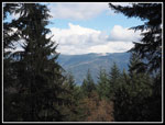
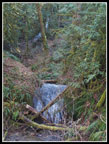
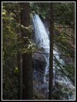
The loop trail climbs almost 800' to a viewpoint. More precisely, a spur off the loop trail goes to the viewpoint. We hiked it counterclockwise. We saw a few folks down low and a few more later on. It was not crowded. The routes seem to be a combination of old roads and newer trails. The trailhead is at about 470' and the viewpoint is at about 1330'. Call it 860' of elevation gain. From the viewpoint we could see a little bit of Whatcom Lake. The view to the mountains was now obscured by clouds. It was till mostly clear overhead but now farther east. I will have to come back to see what mountain view is like. Mt. Baker is slightly north and east. It may or may not be visible. We dropped to the loop trail and continued down. The up route was a more narrow trail. The down route was on an old road. Both were in fine shape. Near the bottom we had a view of a close by water fall and part of one higher up. We would have to hike up to the waterfall viewpoint.
The trail up is short climbing to a wooden viewpoint with rails around for safety. The lower falls is not in sight here but the upper falls is. Quite a nice waterfall this time of year when the creeks are full. We continued up to the end of the trail. we expected another viewpoint. We reached the creek with no waterfall and no obvious trail on the other side. Oh well, the lower falls were nice enough. We dropped a short way down the trail and took another trail over to the main road. This provided a shorter route back to the trailhead. We made it back at 3:45 pm. We hiked 5 miles with about 1100' of gain. Adding in the first hike we had about 9.5 miles with 1400' of gain for the day. Not bad for two leisurely paced hikes.
We never did get to hike the trip we planned but our Plan B turned out to be a fun day. A city park and a new forest preserve provided plenty of variety. I will be interested in a return trip to Lookout Mountain trails when there are 12 miles vs the current 6 miles of trails. It was fun to get out on another hike with Gwen. The sunny day was much appreciated. I also added two new trips in one day. I aim for at least ten new trails each year and I logged 20% of than in one day. We made the most of our last minute change of plans.
Click on thumbnails to get
larger pictures.
Trips - 2018
Home
Immediately we reached the Stone Bridge, built by the CCC in 1939. It crosses Whatcom Creek just downstream of Whatcom Falls. The falls are quite impressive. Not that tall but plenty wide. Well, 100' into the trip we had already seen the falls. We managed to hike most of the trails in the park. The park is narrow encompassing both sides of the creek from Lake Whatcom down to Woburn Street. We turned downstream at first. There were a number of folks in the park but it was not crowded. The creek is in a forested gorge. It is full of white water and the sound of rushing water. A section of the trail is an off leash dog park. Lots of dogs on the trail. Gwen had to visit each one. The owners were happy to comply. Nearing Woburn Street and the end of the park we found an entrance into the Bayview Cemetery. Fascinating bits of history here. In just the section we walked one person's death dated to 1909. Our original planned hike goes to the Cyrus Gates Overlook. Gwen found the headstone for Cyrus Gates. His history is important to early days in the Bellingham area.
We continued on to a trail along the top of the gorge of Whatcom Creek. It was along this part of the creek that a pipeline explosion in 1999 killed three people and burned a good chunk of the area along the creek. These parts are still off limits as it heals. A wet spot along here provided our first look at nice yellow skunk cabbage. Gwen would say bog lanterns. I did not expect them to be flowering yet. We completed a loop and followed the main trail back across the (water) Pipeline Bridge and back to where we started. We continued on towards Lake Whatcom. We scoped out another falls and a series of small and large trails. Some trails go off to nearby neighborhoods. A big surprise was a short spur trail to the remains of an old wooden railroad trestle. A part of it is gone leaving a gap. Rails still sit atop the trestle. There are not many like it around anymore. Research shows it was built in 1916 to move lumber from the Larson Mill to Bellingham Bay.
We reached the end and crossed Electric Avenue to Bloedel Donovan Park on the shore of Lake Whatcom. A sunny day by the lake for lunch is not so bad. After a long break we headed back. This time we stayed on this side of the creek. This took us by the other side of the railroad trestle. It is high above the ground. No connection on this end either. The path took us back to the fish hatchery next to the parking lot. It was 12:20 by the time we reached the car. We took almost 3.5 hours to hike just under five miles. A pace conducive to enjoying the park rather than racking up miles. Now we headed off for hike number two.
Before settling on the Fragrance Lake - Rock Trail trip we discussed several other trails near Bellingham. One was the Lookout Forest Forest Preserve. This 4430 acre preserve is administered by the Whatcom County Parks and Recreation Department. Here is a link to information on the preserve. It is located just west of Lake Whatcom and east of I-5. The forest preserve is very new. It currently has 6 miles of trails and 8 miles of roads to walk or bike. The plan is to add 6 more miles in the summer of 2018. We managed to hike most of the trails. There were close to a dozen cars in the lot when we arrived at 12:45 pm. We were soon on our way. A road goes out of the parking lot and a trail does to. We headed out the trail. We hiked in forest for half a mile to a crossing of the road. Just after are junctions. First, one to a viewpoint of waterfalls. We passed that by. Next is the start and finish of a loop.
The loop trail climbs almost 800' to a viewpoint. More precisely, a spur off the loop trail goes to the viewpoint. We hiked it counterclockwise. We saw a few folks down low and a few more later on. It was not crowded. The routes seem to be a combination of old roads and newer trails. The trailhead is at about 470' and the viewpoint is at about 1330'. Call it 860' of elevation gain. From the viewpoint we could see a little bit of Whatcom Lake. The view to the mountains was now obscured by clouds. It was till mostly clear overhead but now farther east. I will have to come back to see what mountain view is like. Mt. Baker is slightly north and east. It may or may not be visible. We dropped to the loop trail and continued down. The up route was a more narrow trail. The down route was on an old road. Both were in fine shape. Near the bottom we had a view of a close by water fall and part of one higher up. We would have to hike up to the waterfall viewpoint.
The trail up is short climbing to a wooden viewpoint with rails around for safety. The lower falls is not in sight here but the upper falls is. Quite a nice waterfall this time of year when the creeks are full. We continued up to the end of the trail. we expected another viewpoint. We reached the creek with no waterfall and no obvious trail on the other side. Oh well, the lower falls were nice enough. We dropped a short way down the trail and took another trail over to the main road. This provided a shorter route back to the trailhead. We made it back at 3:45 pm. We hiked 5 miles with about 1100' of gain. Adding in the first hike we had about 9.5 miles with 1400' of gain for the day. Not bad for two leisurely paced hikes.
We never did get to hike the trip we planned but our Plan B turned out to be a fun day. A city park and a new forest preserve provided plenty of variety. I will be interested in a return trip to Lookout Mountain trails when there are 12 miles vs the current 6 miles of trails. It was fun to get out on another hike with Gwen. The sunny day was much appreciated. I also added two new trips in one day. I aim for at least ten new trails each year and I logged 20% of than in one day. We made the most of our last minute change of plans.
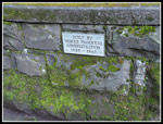 Stone Bridge Plaque |
 Whatcom Falls |
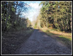 Road/Trail |
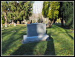 Cyrus Gates |
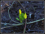 Skunk Cabbage! |
 Whatcom Creek |
 Narrow Falls |
 Side Of Whatcom Falls |
 Gwen Atop Falls |
 Small Step Falls |
 Mossy Rocks |
 Uphill Trail |
 Missing Tracks |
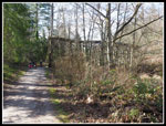 Approaching Trestle |
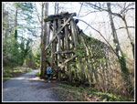 Gwen & Trestle |
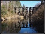 Trestle Reflection |
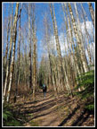
 Lookout Mt. Trail |
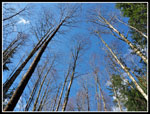 Blue Sky Above |
 Tall Skinny Trees |
 Mossy Tree |
 Viewpoint View |
 Old Road Trail |
 Two Falls |
 Colorful Moss |
 Upper Waterfall |
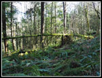
 Twin Nurse Logs |
 Really Mossy |
 Trailhead |
Trips - 2018
Home