8-17-19
It
would be another overcast August Saturday and I decided on a short
drive to a destination with no views. Another lake it would be. At one
time before I started hiking regularly the Granite Creek road was open
to the Thompson Lake Trailhead. It was a very short hike to the lake.
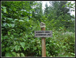
That trail is the Defiance Trail. The other end of it starts where the
Pratt Lake Trail drops to Pratt Lake. That end of it I hike almost
every year. The road has been closed for decades and it is now a long
road walk to the old trailhead. I found out about a short cut and hiked
to Thompson Lake for the first and only previous time in 2013.
Since then a new trail has replaced the old short cut boot path. Now
the
first and last 1.2 miles avoids the Granite Creek Road/Trail on nice
new tread. Back in 2004 I was on a Mountaineer snowshoe trip to Point
5124 high above the Defiance Trailhead. I passed it on the road for the
first time that day. My 2013 trip was in late October. The day was
short and cold. This trip would be slightly warmer but less sunny.
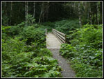
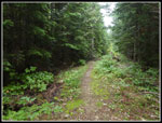
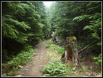
I left town at about 7:00 am and headed east then up the Middle Fork Snoqualmie Road. Now that it is paved it takes much less time to reach the 840' trailhead. I arrived at 7:52 am. The lot had about half a dozen cars in it. Mailbox Peak, just down the road, had the usual overflow parking at 7:45 am. I was on the trail at 8:00 am. It was completely overcast as forecast and cool but not cold. I felt lethargic at first but soon came around. The smooth trail makes for easy hiking as I ascended the trail. After 30 minutes I reached the junction with the Granite Creek Road/Trail. My gps recorded 1.2 miles with 860' of gain. I stopped to switch into a short sleeve short and zip off my pants legs. It was a bit humid and noticeably warmer now.
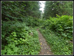
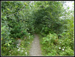
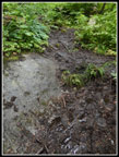
I quickly hiked up to the bridge over Granite Creek. On the other side the brush began to get taller and closer to the trail. When the old road was decommissioned several years back all the culverts were removed and a big concrete bridge over Granite Creek. The road bed was broken up a bit and logs and rocks placed to make it less of a straight road. It has now narrowed down to trail width. Unfortunately, less than trail width in places. Without continuous brushing this trail will become difficult to hike. There was dew this morning and in places it was not possible to get by without the water getting on the hikers. I whacked away some of the encroaching brush with my poles. All that said it was no problem hiking the trail, I just got a little wet. Some recent trip reports made it sound like a full on bushwhack. It is not nearly that bad.
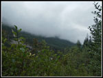
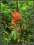
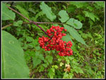
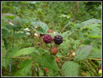
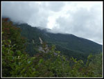
Mailbox Peak was now up above me and I could not see a thing. The summit was completely in the clouds. I was not. At least not yet. About .75 miles before the junction with the trail down to Granite Lakes I passed the first two people of the day. Their dog followed after me but thankfully did return to his group. I reached the trail junction at 9:33 am. After the junction the encroaching brush lessened. Though fewer folks hike this section it is much more open. I saw a few wildflowers along here. The bulk of them are done for the year. I saw lots of pearly everlasting and some Indian paintbrush. There was also foxglove and fireweed. There were also big red bunches of mountain ash berries. As I neared the old Defiance Trailhead I met a lone hiker coming down. He went almost to the high point before the lake in thick wet clouds and decided to head back. I was getting a little concerned about the very steep and wet trail down to the lake.
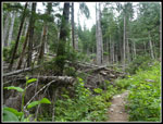
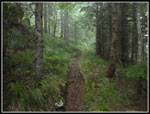
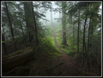
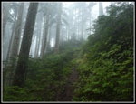
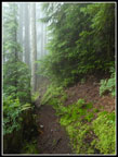
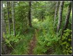
I soon left the old road and went onto real trail. With the long distance via the old Granite Creek Road this trail had not had much traffic over the years. The forest is intact though and there is little brush. Though narrow the tread is not too bad. It starts with the remains of a whole lot of bear grass. Then the underbrush disappears. The trail drops steeply, crosses and creek, and climbs back up. It is then a steady climb to the ridge top where the route goes over and drops to the lake. I was quickly in the deep dark clouds. Moisture coated everything. Visibility was minimal. I was thinking I would drop down to a lake I would barely be able to see. I hoped it would get back below the cloud level. Someone cut out a good sized tree that was across the trail on a steep slope. It would not have been fun to get over it.
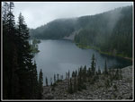
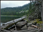
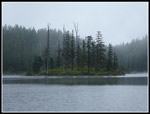
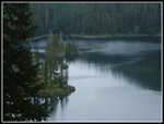
I reached the ridge top at 10:30 am. The high point is at 4300'. That makes for 3460' net feet of gain. about 3550' including the drop on the Defiance Trail. The lake was close by but far below the ridge. The 630' drop is steep. It was a little slick with the wetness but not nearly as bad as I feared. I reached a viewpoint at the edge of the big boulder field then the route went back into forest before returning to the boulders near the lake shore. The lower part of the route was pretty muddy but that part was short. I arrived at the lake at 10:56 am. I took 2:56 to hike 5.6 miles gaining 3550' with over 700' of elevation loss. There was one fisherman at the lake. The fourth person I saw on the entire hike to the lake. So much for overcrowded trails. I did drop below the main cloud level though there were wispy clouds blowing across the lake. I could see most of the way down the lake. Though it was a cool day my shirt was soaking wet with sweat and mist. Time for the dry long sleeve shirt.
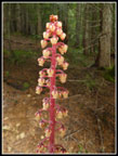
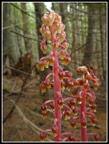
I was in no hurry to rush back. The fisherman was talkative and though we were 75' apart it was easy to converse in the quiet still lake basin. He too was just out for a day hike. I was panning around the lake taking a short video when I reached the fisherman just as he hooked a fish. I continued filming as he brought in a nice sized trout. He then let it go. Two other hikers arrived. The four of us were the only folks at the lake while I was there. I spent just under an hour at the lake. I packed up and headed out at 11:47 am. Footing was much better going up the trail. I had no trouble getting back to the ridge top. On the hike back to the Defiance Trailhead I passed a group of two and a lone hiker coming in. Once back on the road/trail I had nothing but pretty smooth grade back to the car. It is an old road and is a bit hard on the feet though. Heading back to the Granite Lakes junction I passed a tall pinedrop plant I had completely missed on the way in. It was near the edge of the old road. Just a few feet away was dark forest with no underbrush. I decided to see if there were more saprophytes in the forest In fact, I found a bunch more pinedrops. Just off the route where nobody would see them.
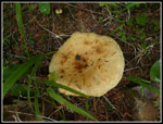
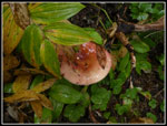
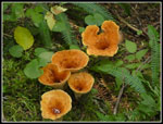
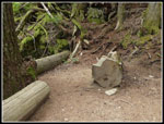
There were a couple more hikers coming in before I reached the Granite Lakes junction. To my surprise I saw only a couple groups on the route back to the bridge over Granite Creek. I must have been after most groups passed by going in and before anyone headed back. I had a lot of solitude on a somewhat busy section of trail. I did also see some orange through the walls of brush along the trail. There were about a dozen good sized mushrooms just off the trail. I reached the bridge to find a lone hiker debating going on. She decided to head back. On the last half mile I did see several more groups coming in. Before that I saw a total of 14 people over the first 10.7 miles. I also stopped for a medium length break at one of the carved log seats at a viewpoint. Not much of a view though the clouds. Even with the breaks I arrived at the trailhead at 2:45 pm. I took 2:58 coming down. Two minutes longer than my ascent but with more stops and photos. For the day I hiked 11.2 miles with just over 4200' of gain. My previous visit was a bit longer as I went to the far end of the lake. This time I just went to the lake and back.
This is an interesting trail. The first part is very nice. The road/trail needs brushing and will never be scenic. No views and not in the forest. The Defiance Trail is fun and the lake is well worth visiting. All in all a mixed bag. I will likely be back in half a dozen years. The drove home was very easy. I was home before 4:15 pm. Surprisingly this trip has slightly more elevation gain than nearby Mailbox Peak. No views but a nice lake. It does not have the crowds.
Click on thumbnails to get
larger pictures.
Trips - 2019
Home
I left town at about 7:00 am and headed east then up the Middle Fork Snoqualmie Road. Now that it is paved it takes much less time to reach the 840' trailhead. I arrived at 7:52 am. The lot had about half a dozen cars in it. Mailbox Peak, just down the road, had the usual overflow parking at 7:45 am. I was on the trail at 8:00 am. It was completely overcast as forecast and cool but not cold. I felt lethargic at first but soon came around. The smooth trail makes for easy hiking as I ascended the trail. After 30 minutes I reached the junction with the Granite Creek Road/Trail. My gps recorded 1.2 miles with 860' of gain. I stopped to switch into a short sleeve short and zip off my pants legs. It was a bit humid and noticeably warmer now.
I quickly hiked up to the bridge over Granite Creek. On the other side the brush began to get taller and closer to the trail. When the old road was decommissioned several years back all the culverts were removed and a big concrete bridge over Granite Creek. The road bed was broken up a bit and logs and rocks placed to make it less of a straight road. It has now narrowed down to trail width. Unfortunately, less than trail width in places. Without continuous brushing this trail will become difficult to hike. There was dew this morning and in places it was not possible to get by without the water getting on the hikers. I whacked away some of the encroaching brush with my poles. All that said it was no problem hiking the trail, I just got a little wet. Some recent trip reports made it sound like a full on bushwhack. It is not nearly that bad.
Mailbox Peak was now up above me and I could not see a thing. The summit was completely in the clouds. I was not. At least not yet. About .75 miles before the junction with the trail down to Granite Lakes I passed the first two people of the day. Their dog followed after me but thankfully did return to his group. I reached the trail junction at 9:33 am. After the junction the encroaching brush lessened. Though fewer folks hike this section it is much more open. I saw a few wildflowers along here. The bulk of them are done for the year. I saw lots of pearly everlasting and some Indian paintbrush. There was also foxglove and fireweed. There were also big red bunches of mountain ash berries. As I neared the old Defiance Trailhead I met a lone hiker coming down. He went almost to the high point before the lake in thick wet clouds and decided to head back. I was getting a little concerned about the very steep and wet trail down to the lake.
I soon left the old road and went onto real trail. With the long distance via the old Granite Creek Road this trail had not had much traffic over the years. The forest is intact though and there is little brush. Though narrow the tread is not too bad. It starts with the remains of a whole lot of bear grass. Then the underbrush disappears. The trail drops steeply, crosses and creek, and climbs back up. It is then a steady climb to the ridge top where the route goes over and drops to the lake. I was quickly in the deep dark clouds. Moisture coated everything. Visibility was minimal. I was thinking I would drop down to a lake I would barely be able to see. I hoped it would get back below the cloud level. Someone cut out a good sized tree that was across the trail on a steep slope. It would not have been fun to get over it.
I reached the ridge top at 10:30 am. The high point is at 4300'. That makes for 3460' net feet of gain. about 3550' including the drop on the Defiance Trail. The lake was close by but far below the ridge. The 630' drop is steep. It was a little slick with the wetness but not nearly as bad as I feared. I reached a viewpoint at the edge of the big boulder field then the route went back into forest before returning to the boulders near the lake shore. The lower part of the route was pretty muddy but that part was short. I arrived at the lake at 10:56 am. I took 2:56 to hike 5.6 miles gaining 3550' with over 700' of elevation loss. There was one fisherman at the lake. The fourth person I saw on the entire hike to the lake. So much for overcrowded trails. I did drop below the main cloud level though there were wispy clouds blowing across the lake. I could see most of the way down the lake. Though it was a cool day my shirt was soaking wet with sweat and mist. Time for the dry long sleeve shirt.
I was in no hurry to rush back. The fisherman was talkative and though we were 75' apart it was easy to converse in the quiet still lake basin. He too was just out for a day hike. I was panning around the lake taking a short video when I reached the fisherman just as he hooked a fish. I continued filming as he brought in a nice sized trout. He then let it go. Two other hikers arrived. The four of us were the only folks at the lake while I was there. I spent just under an hour at the lake. I packed up and headed out at 11:47 am. Footing was much better going up the trail. I had no trouble getting back to the ridge top. On the hike back to the Defiance Trailhead I passed a group of two and a lone hiker coming in. Once back on the road/trail I had nothing but pretty smooth grade back to the car. It is an old road and is a bit hard on the feet though. Heading back to the Granite Lakes junction I passed a tall pinedrop plant I had completely missed on the way in. It was near the edge of the old road. Just a few feet away was dark forest with no underbrush. I decided to see if there were more saprophytes in the forest In fact, I found a bunch more pinedrops. Just off the route where nobody would see them.
There were a couple more hikers coming in before I reached the Granite Lakes junction. To my surprise I saw only a couple groups on the route back to the bridge over Granite Creek. I must have been after most groups passed by going in and before anyone headed back. I had a lot of solitude on a somewhat busy section of trail. I did also see some orange through the walls of brush along the trail. There were about a dozen good sized mushrooms just off the trail. I reached the bridge to find a lone hiker debating going on. She decided to head back. On the last half mile I did see several more groups coming in. Before that I saw a total of 14 people over the first 10.7 miles. I also stopped for a medium length break at one of the carved log seats at a viewpoint. Not much of a view though the clouds. Even with the breaks I arrived at the trailhead at 2:45 pm. I took 2:58 coming down. Two minutes longer than my ascent but with more stops and photos. For the day I hiked 11.2 miles with just over 4200' of gain. My previous visit was a bit longer as I went to the far end of the lake. This time I just went to the lake and back.
This is an interesting trail. The first part is very nice. The road/trail needs brushing and will never be scenic. No views and not in the forest. The Defiance Trail is fun and the lake is well worth visiting. All in all a mixed bag. I will likely be back in half a dozen years. The drove home was very easy. I was home before 4:15 pm. Surprisingly this trip has slightly more elevation gain than nearby Mailbox Peak. No views but a nice lake. It does not have the crowds.
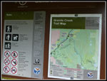 Trailhead Map |
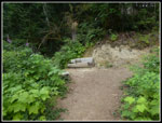 Trailside Bench |
 First Junction |
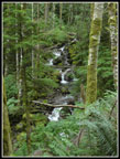 Granite Creek |
 Granite Creek Bridge |
 Trail Narrows |
 Big Blowdowns |
 Where's Mailbox? |
 Getting Brushier |
 Indian Paintbrush |
 Granite Lakes Junction |
 Road/Trail Widens |
 Mountain Ash Berries |
 Mushroom |
 I'm Stumped |
 Defiance Trail |
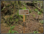
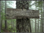 Old Trail Sign |
 Cloudy Ridge Top |
 Wet Mushroom |
 Steep Trail |
 First View Of Lake |
 Lake Shore |
 Island |
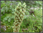 Beargrass |
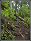
 Muddy Trail |
 Heading Out |
 Almost To Ridge Top |
 In The Clouds |
 Grassy Trail |
 Pinedrop |
 Saprophyte City |
 Ripening Berries |
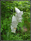 Foxglove |
 Mailbox Almost In Sight |
 Orange Mushrooms |
 Twin Benches |
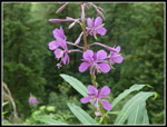 Fireweed |
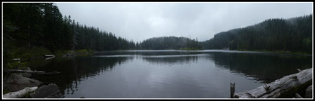 Panorama Shot Of Thompson Lake |
Trips - 2019
Home