8-04-19
Gary
was free and wanted to head to the North Cascades. He suggested
Trappers Peak. I first read about the hike/scramble of the peak some 35
years ago in "101 Hikes in the North Cascades". Several times I had the
trip planned and something came up. When Mike McQuaide interviewed me
for the Seattle Times I suggested we hike up Trappers. He had done it
the previous week so we hiked up Lookout Mountain instead. Something
always came up. The past few years my Subaru was not reliable enough to
tackle the road. Now I have a newer four wheel drive car taking away
that excuse. On the downside the temperature in Seattle would be near
90 degrees. Ditto for Darrington. The upper mountain would be totally
out in the open. No summit shade. With all that we decided on the trip
with an early start. I met Gary in South Everett at 5:55 am. We headed
north to Arlington, then on to Darrington and up to Highway 20. Eleven
miles north of Marblemount we turned onto the five mile long dirt road
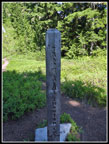
to the Thornton Lakes Trailhead.
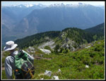
The road was graded last fall and much of it is okay. There are a lot of steep switchbacks and several of them have tire churned holes that make traction tenuous. The road is very steep. We found three turnout filled with folks camping. So much for places to pass oncoming traffic. It was slow but we made it to the trailhead at about 7:55 am. There were five or six cars in the small lot at the end of the road. More folks than I expected. The trail enters North Cascades National Park so camping is limited by permit. They were all used on Saturday night. Me passed several groups coming down while we hiked up. One guy was getting ready who had very low ground clearance. I can't believe he made it up without multiple bottoming out on his car. It was only 63 degrees when we started hiking at 8:10 am. The route starts on an old road. It has become more of a trail. Smooth with little elevation gain it hikes very fast. There were not many wildflowers left. Just a few here and there.
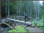
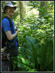
The road turned to cross a creek and shortly crossed another. The first was an easy rock hop and the second crosses on a log bridge. All the way from the trailhead is in forest. That helps on a hot day. We reached the end of the road and the trail now began to climb. The road section was about 2.2 miles with 650' of elevation gain. It only took us 45 minutes. We were almost half way to the lake/peak junction and it was still before 9:00 am. The trail is not as smooth as the road section. Lots of rocky steps and narrow spots. Not a bad trail but steeper and not so smooth. We slowed down but still kept up a good pace. Still mostly in forest with a few small meadows. We met two guys coming down. They had gone over Trappers and X Peaks to a high camp.
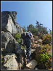
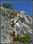
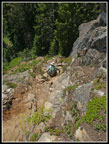
We crossed into North Cascades National Park at about 3.7 miles. The last three quarters of a mile to the junction were steeper. We reached the junction at 10:07 am, just about exactly two hours to hike abut 4.35 miles. That left just .70 miles to gain the last 1000'. We met two groups at the junction heading down. Gary had been up Trappers a couple of times. He had not been to the lakes. Not this day either. After a 16 minute break at the junction, we headed on. It did not take long for the trail to get more interesting. A single guy passed us here and we had a chance to watch him scramble the first steep section. It was steep enough we let him get well ahead before we followed. A rock kicked loose and falling would be a problem.
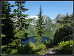
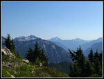
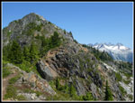
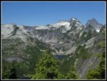
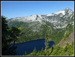
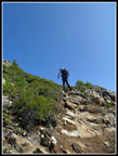
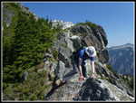
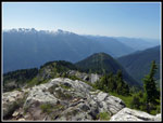
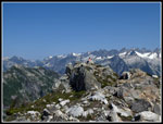
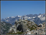
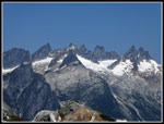
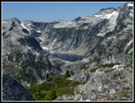
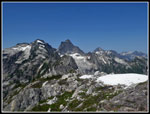
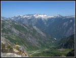
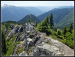
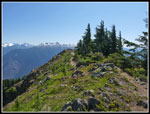
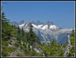
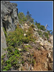
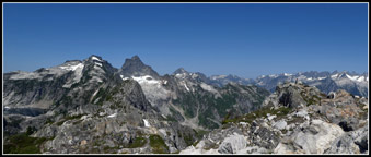
The route just goes straight up. A little dirt and some solid rock too. It looks worse than it is. We were careful and made it up just fine. This is no linger hiking. A fall would be very painful. Only proceed if you are comfortable. After the steep short climb the route opens up on a flatter ridge top. The ridge is a highlight of the trip. Views just keep getting better as you climb higher. We had a view down to Lower then Middle Thornton Lakes. A little higher and the upper lake came into view. There was quite a bit of haze but we were able to pick out Jack and Crater, and Whitehorse and Three Fingers and many more peaks. This is an angle I have not been at looking at the North Cascades peaks. Many I could not name. The ridge is mostly pretty easy hiking. There is one steep drop to a saddle then a steep climb up the other side. Not really exposed. I had heard of a tarn on the ridge. As of now it is more like a big puddle.
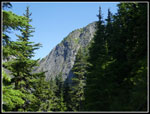
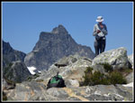
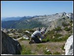
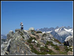
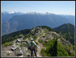
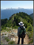
We were constantly taking photos. With all the stops and the steep sections we were not moving very fast. So be it. There is a very short spot where the ridge top is just rock. We had no trouble getting across it. The summit seemed to be nearly vertical above as we approached. I could not see where a trail would go up. The last part is very steep but it goes just fine. At 11:26 am we reached the top. The solo hiker who passed us at the start of the ridge was leaving as we arrived. Two women were at the other side of the summit. The summit area is pretty big. Room for a whole lot of people. It did not look that way from below. We took just about one hour to hike the last .70 miles. Taking time for photos was well worth the slow pace.
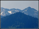
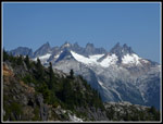
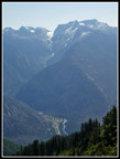
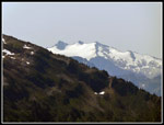
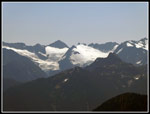
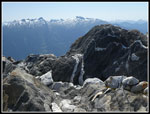
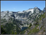
The views on top are pretty spectacular. We could see all three Thornton Lakes. Mt Triumph was above the upper lake. To the north the Picket Range was laid out. Right below us was Newhalem. With maximum zoom I was able to pick out Lookout Mountain. Glacier Peak was hidden by peaks to the southeast. Views to the north were pretty clear. To the south they were much more washed out. There was no shade and it was getting pretty hot. I used a chrome dome umbrella which provided portable shade. That made it comfortable for me to enjoy a long summit stay. After about half an hour the two women headed down. For the next seventy minutes we had the summit to ourselves. Solitude on a popular hike. At 1:00 pm we heard voices from below. We packed up and waited for them to reach the top. Passing a group of four near the top would be a pain. We just waited our turn.
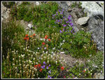
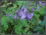
At 1:10 we headed down. The first very steep section proved to be no problem to down climb. Along here we did see the single best flower display. Indian paintbrush, penstemon, and partridge foot were mixed together. The haze to the east was improving allowing some better photos in that direction. We were not in a hurry to get off the ridge. Well, not until the heat really began to get to me. Down at the junction we would find shade. We were a little concerned about climbing down the last steep section but it went just fine. We took another break at the junction. I was afraid the bugs would be a real problem. We did have small non biting flies on the upper half of the route. There were some mosquitoes too. All in all, they were much less of a problem than expected.
The forest was cooler but not cool. On the drive home it was 87 in Darrington. It was just a hot summer day. From the junction to the start of the road section is about half the distance to the trailhead. We took to calling this section the never ending trail. I felt we were moving at a steady pace but we never seemed to get there. After a while it was a little depressing. We took nearly 1.5 hours to hike a couple miles. Once on the road our pace picked up substantially. We did nearly double the speed on the flatter and smooth old road section. Well before I expected we were back at the trailhead. We arrived at 4:33 pm. Still plenty early. A Toyota Camry was at the trailhead. I guess if you are determined you can get a lot of sedans up the road Going down the road was much easier. We had a pretty easy drive home with a dinner stop in Arlington.
Over 3 1/2 decades after I read about this trip I finally made it to the summit. The haze was a little disappointing but we still had some very good views. Gary and I love ridge walks and this one was among the best. Having over an hour alone on the summit was icing on the cake. It was a very warm day but not too bad. It was nice to get this one in the books. A really fun scramble. I love the views from North Cascades peaks and these were terrific. Hopefully I will find time to return one day.
Click on thumbnails to get
larger pictures.
Trips - 2019
Home
The road was graded last fall and much of it is okay. There are a lot of steep switchbacks and several of them have tire churned holes that make traction tenuous. The road is very steep. We found three turnout filled with folks camping. So much for places to pass oncoming traffic. It was slow but we made it to the trailhead at about 7:55 am. There were five or six cars in the small lot at the end of the road. More folks than I expected. The trail enters North Cascades National Park so camping is limited by permit. They were all used on Saturday night. Me passed several groups coming down while we hiked up. One guy was getting ready who had very low ground clearance. I can't believe he made it up without multiple bottoming out on his car. It was only 63 degrees when we started hiking at 8:10 am. The route starts on an old road. It has become more of a trail. Smooth with little elevation gain it hikes very fast. There were not many wildflowers left. Just a few here and there.
The road turned to cross a creek and shortly crossed another. The first was an easy rock hop and the second crosses on a log bridge. All the way from the trailhead is in forest. That helps on a hot day. We reached the end of the road and the trail now began to climb. The road section was about 2.2 miles with 650' of elevation gain. It only took us 45 minutes. We were almost half way to the lake/peak junction and it was still before 9:00 am. The trail is not as smooth as the road section. Lots of rocky steps and narrow spots. Not a bad trail but steeper and not so smooth. We slowed down but still kept up a good pace. Still mostly in forest with a few small meadows. We met two guys coming down. They had gone over Trappers and X Peaks to a high camp.
We crossed into North Cascades National Park at about 3.7 miles. The last three quarters of a mile to the junction were steeper. We reached the junction at 10:07 am, just about exactly two hours to hike abut 4.35 miles. That left just .70 miles to gain the last 1000'. We met two groups at the junction heading down. Gary had been up Trappers a couple of times. He had not been to the lakes. Not this day either. After a 16 minute break at the junction, we headed on. It did not take long for the trail to get more interesting. A single guy passed us here and we had a chance to watch him scramble the first steep section. It was steep enough we let him get well ahead before we followed. A rock kicked loose and falling would be a problem.
The route just goes straight up. A little dirt and some solid rock too. It looks worse than it is. We were careful and made it up just fine. This is no linger hiking. A fall would be very painful. Only proceed if you are comfortable. After the steep short climb the route opens up on a flatter ridge top. The ridge is a highlight of the trip. Views just keep getting better as you climb higher. We had a view down to Lower then Middle Thornton Lakes. A little higher and the upper lake came into view. There was quite a bit of haze but we were able to pick out Jack and Crater, and Whitehorse and Three Fingers and many more peaks. This is an angle I have not been at looking at the North Cascades peaks. Many I could not name. The ridge is mostly pretty easy hiking. There is one steep drop to a saddle then a steep climb up the other side. Not really exposed. I had heard of a tarn on the ridge. As of now it is more like a big puddle.
We were constantly taking photos. With all the stops and the steep sections we were not moving very fast. So be it. There is a very short spot where the ridge top is just rock. We had no trouble getting across it. The summit seemed to be nearly vertical above as we approached. I could not see where a trail would go up. The last part is very steep but it goes just fine. At 11:26 am we reached the top. The solo hiker who passed us at the start of the ridge was leaving as we arrived. Two women were at the other side of the summit. The summit area is pretty big. Room for a whole lot of people. It did not look that way from below. We took just about one hour to hike the last .70 miles. Taking time for photos was well worth the slow pace.
The views on top are pretty spectacular. We could see all three Thornton Lakes. Mt Triumph was above the upper lake. To the north the Picket Range was laid out. Right below us was Newhalem. With maximum zoom I was able to pick out Lookout Mountain. Glacier Peak was hidden by peaks to the southeast. Views to the north were pretty clear. To the south they were much more washed out. There was no shade and it was getting pretty hot. I used a chrome dome umbrella which provided portable shade. That made it comfortable for me to enjoy a long summit stay. After about half an hour the two women headed down. For the next seventy minutes we had the summit to ourselves. Solitude on a popular hike. At 1:00 pm we heard voices from below. We packed up and waited for them to reach the top. Passing a group of four near the top would be a pain. We just waited our turn.
At 1:10 we headed down. The first very steep section proved to be no problem to down climb. Along here we did see the single best flower display. Indian paintbrush, penstemon, and partridge foot were mixed together. The haze to the east was improving allowing some better photos in that direction. We were not in a hurry to get off the ridge. Well, not until the heat really began to get to me. Down at the junction we would find shade. We were a little concerned about climbing down the last steep section but it went just fine. We took another break at the junction. I was afraid the bugs would be a real problem. We did have small non biting flies on the upper half of the route. There were some mosquitoes too. All in all, they were much less of a problem than expected.
The forest was cooler but not cool. On the drive home it was 87 in Darrington. It was just a hot summer day. From the junction to the start of the road section is about half the distance to the trailhead. We took to calling this section the never ending trail. I felt we were moving at a steady pace but we never seemed to get there. After a while it was a little depressing. We took nearly 1.5 hours to hike a couple miles. Once on the road our pace picked up substantially. We did nearly double the speed on the flatter and smooth old road section. Well before I expected we were back at the trailhead. We arrived at 4:33 pm. Still plenty early. A Toyota Camry was at the trailhead. I guess if you are determined you can get a lot of sedans up the road Going down the road was much easier. We had a pretty easy drive home with a dinner stop in Arlington.
Over 3 1/2 decades after I read about this trip I finally made it to the summit. The haze was a little disappointing but we still had some very good views. Gary and I love ridge walks and this one was among the best. Having over an hour alone on the summit was icing on the cake. It was a very warm day but not too bad. It was nice to get this one in the books. A really fun scramble. I love the views from North Cascades peaks and these were terrific. Hopefully I will find time to return one day.
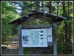 Trailhead Signboard |
 Gary On Bridge |
 First Look At Lake |
 Half Of Trappers Peak |
 Scramble Spot |
 View East |
 Lookout Mountain |
 Picket Range In Sight |
 Trappers & Pickets |
 Upper Lakes |
 Newhalem |
 Thornton Lakes |
 Gary Climbing |
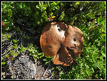 Big Mushroom |
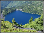 Lower Thornton Lake |
 Narrow Rock Ridge |
 Looking Back |
 Folks On Summit |
 Distant Glacier |
 Distant Peaks |
 Gary On Summit |
 Pickets Close Up |
 Upper Lake |
 Snow Patches |
 Deep Valley |
 Big Peak |
 Gary At Work |
 Neat Rock |
 Still At Work |
 Heading Down |
 Steep Descent |
 Flower Garden |
 Narrow Ridge |
 Ridge Top Hiking |
 Lakes & Mt. Triumph |
 Drop Ahead |
 Flat Ridge |
 Last Pickets View |
 Last Steep Spot |
 Steep Section |
 Junction Sign |
 Skunk Cabbage Leaves |
 Bleeding Hearts |
 Panorama View From Trappers Peak |
Trips - 2019
Home