9-29-19
September
is usually one of my best hiking months. This year things got in the
way. Twenty days into he month I had only three hikes for 30 miles with
6100' of elevation gain. In the next nine days I would hike 41 miles
with 11,800' of gain. This last weekend day of the month would tie my
longest day hike of the year. This one was 17 miles with 2600' of gain.
I had done the long walk from Highway 18 to the summit of West
Rattlesnake Mountain several times over the years. Then the culvert for
Canyon Creek washed out leaving a difficult crossing in the fall when I
like to to this hike. For a number of years I stayed away. Then when I
noticed on a satellite view that a new bridge was in place I returned.
This is the third straight fall day I have done this hike. The road
walk provides a brush free long hike on a smooth surface. Nice features
when rain soaks the forest in the fall. It also hikes very fast. I can
average about 3 mph for the whole trip. The days are getting shorter
and this one can be done comfortably in daylight. It also is not
popular. Near total solitude is expected until near the summit.
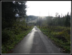
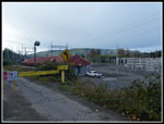
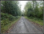
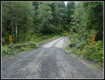
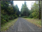
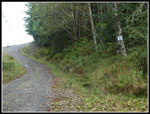
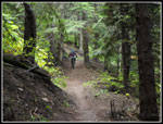
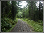
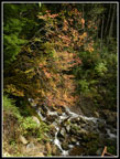
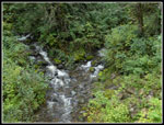
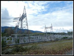
I headed out at 7:12 am and arrived at the start at 7:50 am. By 7:55 am I was on my way. Surprisingly the gate was open. On my return it was closed and locked. The first half mile is paved and it was wet. Wet but not raining. I made it all the way up and down without rain. There were a few drops later but that was it. I planned to set a comfortable pace but it is so smooth and mostly flat that I still ended up under 20 minutes per mile. At one mile I reached the big power substation. The wet lines were making a loud buzzing sound. There are mile and half mile markers most of the way up. A couple are missing since last year. For the most part I constantly knew how far I had come and how far still to go. At 2.5 miles I crossed the new bridge over Canyon Creek. I stopped to peal off a layer before the climbing began. It was 41 degrees at the start and as chilly as I have felt since last winter.
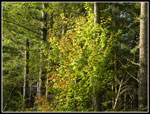
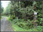
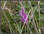
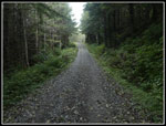
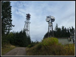
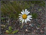
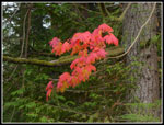
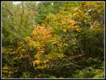
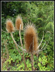
The first climb is steep as the road goes right up the fall line. There is one small space where two summit towers are in sight. The climb is heading east toward the towers. At the top it turns right (south) and levels out again. Easy walking up to the 4.5 mile marker. That is right at the junction with the summit road. A left turn takes off more steeply uphill. Most all the flowers were done. I did see a few daisies in bloom, some goldenrod, pearly everlasting, and foxglove. Just a few of each were hanging on. The lower part usually has a good yellow leaf show in early November. This year there were a few good leaf spots but for the most part leaves have already fallen or are not colorful. It does not look like there will be any more color. At 5 mils the road switches back and has another steep climb. It goes on until a switchback at 5.5 miles. More climbing ensues.
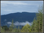
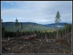
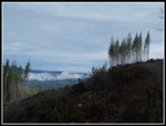
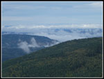
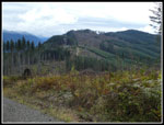
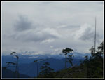
By the 5 mile point the route is in and out of recent clear cuts. This allows more sun to shine in and opens views out. The old cathedral roofed trail under tall trees is gone however. I could see low clouds below me and some higher up. The cloud show were pretty good. The last mile marker for my route is at 6 miles. Before 6.5 miles I reached the last junction. Straight ahead goes down. By the map you can now get all the way back to the start by that route. It is more direct and shorter too. Who wants shorter? I turned right on the summit road. I soon came to the 5 mile marker. The new road's mileage markers now take over. I saw two bikes come out of the woods and then cross the road and go back into forest. They were the first folks I had seen all day. When I reached that spot I saw a sign stating that this unofficial trail has been closed to allow re-vegetation. These trails are bot built to last and get really muddy.
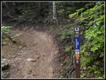
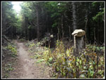
A little farther up I reached the new bike trail to near the top of West Rattlesnake. I have hiked it from Stan's Overlook several times. It is too busy with bikes for me to hike it now except under snow or early in the morning. I was 6.67 miles along and it was still only 10:14 am. Early enough to take the trail. The road goes on then switchbacks twice before reaching the summit. The trail largely follows the road but crosses over it two times. The trail is probably a little shorter. The soft tread felt good on my feet after all the road walking. I also found some fresh mushrooms along the trail. One lone biker passed me on this section. At the second road crossing I followed the trail across and back into forest. In just a few minutes I entered a clear cut at the trail's high point. There are some very nice views here.
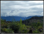
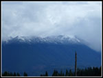
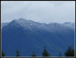
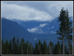
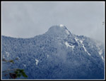
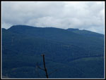
Mt. Rainier was entirely in the clouds. Most of the closer peas were largely in the open. Some of the peaks and ridge tops were buried in white. I stopped for a break here. This is just under 8 miles up. I arrived at 10:47 am. About 8 mile up in 2:52 including several stops and a number of photos. Just over 21 minutes per mile uphill with breaks is pretty fast for me. There was a bit of a cold breeze so I put on more layers. Glovers had been going on and off all day. I did not have a thermometer on my summer day pack but it must have been around 40 plus the breeze. All around I could see the snow level. The storm of the previous couple days had left white on everything above about 3500'. West Rattlesnake is at 3262'. I just missed the snow. A biker arrived and we had a fun conversation. He was just getting back into mountain biking. He left and another biker arrived. I soon packed up as 3 or 4 more bikers arrived. It is a popular trail.
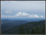
I went back to the road and turned right for the short climb to the summit. I went over the top and down the road to the lower towers. Here I had a look around the trees to the peaks all around. Mt. Si was partly in the clouds. Mt. Teneriffe was entirely in the clouds. I could see the MF Snoqualmie Valley and Mailbox Peak was in the clouds too. Mt. Washington was in the clear. Five days earlier I was struggling on Tiger Mountain in after noon head and humidity. Now it looked and felt like winter. Quite a change. I went back to the summit and finished my lunch. At the lower tower I saw a 6.5 mile marker. It is 1.5 miles by the road from the 5 mile marker I found when I started up the new road section. On my way down I used my phone gps to fill in the blank from the 6 mile marker on the original road and the 5 mile marker on the new road to verify the total distance I hiked down.
After lunch I started down. It was now 11:22 am. For the route down I stayed on the road rather than take the trail section again. As expected I did not see anyone on the road. I'm sure there were a number of bikers I would have passed on the trail. Below where I started up the trail earlier I passed two bikers pushing their bikes up the road. I'm not sure If they came up my route or not. Below the 6 mile marker I passed a lone biker pedaling up one of the steepest sections. He did pass me later on the way down. So one or possible three other people took my route this day. The rest of the way down was pretty easy walking. Me feet did get a bit sore the last couple miles. At the top of the first steep climb I took a detour over to the upper Canyon Creek Bridge. It adds .75 miles over and back to bring my day's total up to 17 miles and adds over 100'' of gain to bring it up to 2600'. I did the same thing last year.
I finally made it back to my car at 2:20 pm. I took 2:58 minutes coming down including the extra 3/4 of a mile detour. Right about a 20 minute per mile pace including stops and photos. This is not a hike I would do in the spring or summer. There are much better places to go. It is a very long trip to some decent views with a very short drive. Good for November when the snow is flying or rain falling. It also is yet another hike which provides near total solitude except at the viewpoint near the top. On top of that it redeemed a very low mileage September. At least u to the last ten days.
Click on thumbnails to get
larger pictures.
Trips - 2019
Home
I headed out at 7:12 am and arrived at the start at 7:50 am. By 7:55 am I was on my way. Surprisingly the gate was open. On my return it was closed and locked. The first half mile is paved and it was wet. Wet but not raining. I made it all the way up and down without rain. There were a few drops later but that was it. I planned to set a comfortable pace but it is so smooth and mostly flat that I still ended up under 20 minutes per mile. At one mile I reached the big power substation. The wet lines were making a loud buzzing sound. There are mile and half mile markers most of the way up. A couple are missing since last year. For the most part I constantly knew how far I had come and how far still to go. At 2.5 miles I crossed the new bridge over Canyon Creek. I stopped to peal off a layer before the climbing began. It was 41 degrees at the start and as chilly as I have felt since last winter.
The first climb is steep as the road goes right up the fall line. There is one small space where two summit towers are in sight. The climb is heading east toward the towers. At the top it turns right (south) and levels out again. Easy walking up to the 4.5 mile marker. That is right at the junction with the summit road. A left turn takes off more steeply uphill. Most all the flowers were done. I did see a few daisies in bloom, some goldenrod, pearly everlasting, and foxglove. Just a few of each were hanging on. The lower part usually has a good yellow leaf show in early November. This year there were a few good leaf spots but for the most part leaves have already fallen or are not colorful. It does not look like there will be any more color. At 5 mils the road switches back and has another steep climb. It goes on until a switchback at 5.5 miles. More climbing ensues.
By the 5 mile point the route is in and out of recent clear cuts. This allows more sun to shine in and opens views out. The old cathedral roofed trail under tall trees is gone however. I could see low clouds below me and some higher up. The cloud show were pretty good. The last mile marker for my route is at 6 miles. Before 6.5 miles I reached the last junction. Straight ahead goes down. By the map you can now get all the way back to the start by that route. It is more direct and shorter too. Who wants shorter? I turned right on the summit road. I soon came to the 5 mile marker. The new road's mileage markers now take over. I saw two bikes come out of the woods and then cross the road and go back into forest. They were the first folks I had seen all day. When I reached that spot I saw a sign stating that this unofficial trail has been closed to allow re-vegetation. These trails are bot built to last and get really muddy.
A little farther up I reached the new bike trail to near the top of West Rattlesnake. I have hiked it from Stan's Overlook several times. It is too busy with bikes for me to hike it now except under snow or early in the morning. I was 6.67 miles along and it was still only 10:14 am. Early enough to take the trail. The road goes on then switchbacks twice before reaching the summit. The trail largely follows the road but crosses over it two times. The trail is probably a little shorter. The soft tread felt good on my feet after all the road walking. I also found some fresh mushrooms along the trail. One lone biker passed me on this section. At the second road crossing I followed the trail across and back into forest. In just a few minutes I entered a clear cut at the trail's high point. There are some very nice views here.
Mt. Rainier was entirely in the clouds. Most of the closer peas were largely in the open. Some of the peaks and ridge tops were buried in white. I stopped for a break here. This is just under 8 miles up. I arrived at 10:47 am. About 8 mile up in 2:52 including several stops and a number of photos. Just over 21 minutes per mile uphill with breaks is pretty fast for me. There was a bit of a cold breeze so I put on more layers. Glovers had been going on and off all day. I did not have a thermometer on my summer day pack but it must have been around 40 plus the breeze. All around I could see the snow level. The storm of the previous couple days had left white on everything above about 3500'. West Rattlesnake is at 3262'. I just missed the snow. A biker arrived and we had a fun conversation. He was just getting back into mountain biking. He left and another biker arrived. I soon packed up as 3 or 4 more bikers arrived. It is a popular trail.
I went back to the road and turned right for the short climb to the summit. I went over the top and down the road to the lower towers. Here I had a look around the trees to the peaks all around. Mt. Si was partly in the clouds. Mt. Teneriffe was entirely in the clouds. I could see the MF Snoqualmie Valley and Mailbox Peak was in the clouds too. Mt. Washington was in the clear. Five days earlier I was struggling on Tiger Mountain in after noon head and humidity. Now it looked and felt like winter. Quite a change. I went back to the summit and finished my lunch. At the lower tower I saw a 6.5 mile marker. It is 1.5 miles by the road from the 5 mile marker I found when I started up the new road section. On my way down I used my phone gps to fill in the blank from the 6 mile marker on the original road and the 5 mile marker on the new road to verify the total distance I hiked down.
After lunch I started down. It was now 11:22 am. For the route down I stayed on the road rather than take the trail section again. As expected I did not see anyone on the road. I'm sure there were a number of bikers I would have passed on the trail. Below where I started up the trail earlier I passed two bikers pushing their bikes up the road. I'm not sure If they came up my route or not. Below the 6 mile marker I passed a lone biker pedaling up one of the steepest sections. He did pass me later on the way down. So one or possible three other people took my route this day. The rest of the way down was pretty easy walking. Me feet did get a bit sore the last couple miles. At the top of the first steep climb I took a detour over to the upper Canyon Creek Bridge. It adds .75 miles over and back to bring my day's total up to 17 miles and adds over 100'' of gain to bring it up to 2600'. I did the same thing last year.
I finally made it back to my car at 2:20 pm. I took 2:58 minutes coming down including the extra 3/4 of a mile detour. Right about a 20 minute per mile pace including stops and photos. This is not a hike I would do in the spring or summer. There are much better places to go. It is a very long trip to some decent views with a very short drive. Good for November when the snow is flying or rain falling. It also is yet another hike which provides near total solitude except at the viewpoint near the top. On top of that it redeemed a very low mileage September. At least u to the last ten days.
 Getting Started |
 Reflection |
 Power Sub Station |
 Straight And Flat |
 Canyon Creek Bridge |
 Tunnel Ahead? |
 First Good Colors |
 4 1/2 Mile Marker |
 Clouds Below |
 Clear Cut View |
 Foxglove |
 Tree Island |
 6 Mile Marker |
 Cloud Show |
 Darker Forest |
 On The Trail |
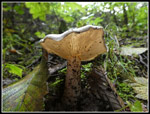 Mushroom |
 Mountain Biker |
 Rocks On Stumps |
 High Point |
 Snow Level |
 Summit Towers |
 Rattlesnake Ridge |
 Mailbox Peak |
 Sky |
 MF Valley |
 Mt. Teneriffe |
 Daisy |
 Heading Down |
 East Tiger & Tiger 1 |
 White Clouds |
 Very Good Colors |
 Best Colors |
 More Leaves |
 Color Near Bridge |
 Lower Canyon Creek |
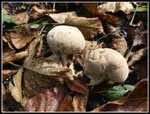 More Mushrooms |
 One Mile To Go |
 Interesting |
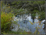 Reflection Again |
Trips - 2019
Home