5-22-21
Gary
was free for a hike. We have been building up difficulty for a possible
Mission Ridge - Devil's Gulch trip in the next few weeks. East of the
crest had high winds and west of the crest forecast clear sky all day.
We chose to stay west. We tossed around several ideas without feeling
good about any of them. I pulled out one last idea. I had done four
trips up South Bessemer Mountain up the Middle Fork Snoqualmie Valley.
It is a road walk to the top but in spring the upper mountain is under
snow. The trailhead is at just over 900;. The summit is 5028'. That
makes for a 13 miles round trip with 4100' of elevation gain. That
makes for a good workout. The views are also surprisingly good. Gary
had not done it which was another plus. He agreed and we planned an
early but not really early start.
For the first time in about 14 months we carpooled. We are both vaccinated for Covid and finally felt okay with resuming one part of normality. We met at High Point just east of Issaquah at 7:00 am. East to just past North Bend then onto the MF Snoqualmie Road. We followed a car down the road. We were certain where that person was headed and we were right. At the Mailbox parking area the gate to the upper lot was open and many dozens of cars were parked next to and in the road. Half the cars along the road were parked over the white line and in the road. This is getting ridiculous. Cars all the way to the small Granite Creek lot and beyond. This was at 7:20 am. Contrary to the forecast the sky was white from Seattle east though there were some breaks over the Middle Fork.
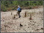
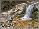
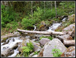
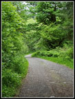
We continued east. On my first 3 trips up South Bessemer the drive from Mailbox to the trailhead took a long time at about 10-15 mph on the old deeply pot holed road. Now that it is paved it took very little time. We parked at Oxbow and had a short walk to the gated road for our route. The previous year there was a big washout that took out parts of the road where it switched back and forth over the offending creek. I was still not sure if the road had been repaired. Recent trip reports did not even mention a washout. We headed for the gated road at 7:36 am at a good pace. It was cool enough for long sleeves and long pants at first. Good conditions overall. We hiked up to the CCC Trail passing two hikes on the way. We did not see many folks all day. Right turn on the CCC then where the road heads up we came to the bottom of the washout creek. A boot path crosses the washout to continue on the CCC trail. We headed uphill.
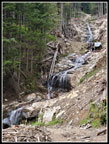
There were two new culverts in the first 1.75 miles from the gate to the rock quarry. After that no culverts have been replaced. It was clear that heavy equipment has cleared up the washouts of the road. At least they are okay to cross on foot. The water level was low enough for us to cross each washout repair spot with dry feet. Not as smooth as the old culverts but not bad to cross. As we switched back higher the road became a bit less smooth. Not bad but not as smooth as the maintained road up to the quarry. The turn off for the old road up to the summit was easy to find. There were half a dozen tall cairns marking the turn off. The old road is much narrower and overgrown that the main road. This point was at about 4.3 miles from the gate at an elevation of about 3150'. We had gained just over half the elevation in 2/3 of the distance. Clearly it is steeper after leaving the main road.
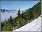
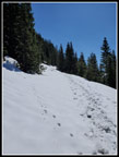
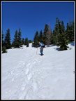
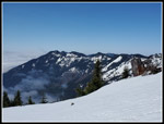
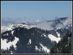
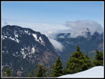
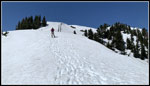
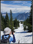
A short way along we hit the first patchy snow at about 3200'. We went back to dirt then the snow returned and became continuous. Over the years I have occasionally forgotten something. This day I put my gear in the back seat of my car as the back was full of Styrofoam heading for recycling. That little change led me to take out my pack but not the poles underneath them. No problem on the road but I had not hiked on steep snow without them in years. It made the trip more "interesting". The snow was well compacted but soft on top. Good for traction. We continued on to the point just below the junction with the spur that heads for Moolock Mountain. From here we were out of the forest and had good mountain views. We were also now atop a cloud layer that had filled the valley. White clouds below and blue sky above. It was not yet hot but the sun on the snow was really bright. We stopped for some food, water, sunscreen, sunglasses, gaiters and microspikes. I replaced my long sleeve shirt with short sleeves but put on a wind shirt. Pant legs zipped off too. The microspikes were not necessary but without poles I needed all the help I could get.
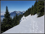
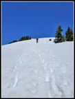
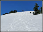
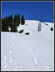
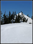
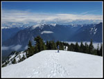
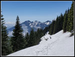
We had been averaging 2.6 mph on the bare roads. On snow our pace dropped significantly. The photo opportunities expanded greatly too. We switchbacked up to the junction then began the long traverse around South Bessemer. We had seen one hiker ahead of us, One who powered right by us, and two more heading down. That was it until the summit. After the long traverse the road takes a 180 degree turn and heads straight for the summit. The footprints we were following gave up on the road and headed right up the fall line. Around some trees and right up open snowfields we went. Towards the top it was much steeper. The softening snow made for fairly secure steps and removed fear of slipping and sliding very far. I took more photos here and Gary found a second wind. He reached the summit ahead of me.
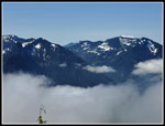
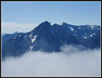
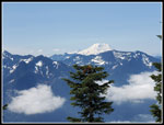
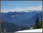
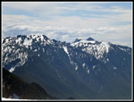
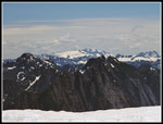
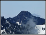
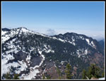
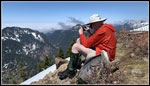
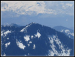
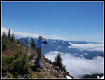
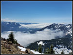
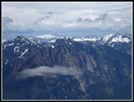
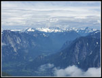
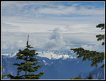
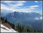
We found a group on the one big bare spot. Snow covered almost everything else. The first summit has been plowed flat as a logging landing. A short drop and climb heads up the the small pointed higher summit. I have been up that one on several occasions and did not feel a need for another. Gary headed over to the slightly higher summit. Most views are the same though the higher summit does have a view of Glacier Peak on a clear day. Gary reached the first summit at 11:31 am. We took 3:55 from Oxbow to the summit. In 2019 I summited in 3:12 with a little less snow and no breaks. Considering the conditions and me slogging around without poles our time was not too bad. I spent 1:26 on top in 2019. We did better this time. The views were really good. Mt. Rainier was clear at first but a few clouds came in later. Most everywhere else was pretty clear. We did see from the summit that most in not all the Puget Sound lowlands were under low clouds. We escaped it by climb above it. Though we were only at 5000' it looked like the view down to clouds from an airplane.
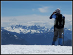
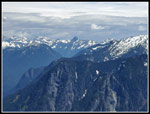
We were in no mood to head back down into the gloom. With my 30x zoom lens I could see people atop Mt. Teneriffe and just make out a few folks on Mailbox Peak. Those summits were much more crowded than us and three others. Those folks left and we had the top to ourselves for about an hour. All totaled we spent 2 hours on the summit. A nice payoff or a 6.5 mile dirt then snow slog up 4100'. At 1:38 we headed down. After carefully descending the first steep section it became easy and fun. I could run down some spots and got in two pitiful glissades. The problem was the view of the Cascade Crest peaks laid out in front of us and the deep valley of the MF right below. The snow highlighted the peaks making for way too many photo stops. Gary noticed what looked like a really tall thunderhead right over Chimney Rock on the Cascade Crest. When we reached the snowy road at the start of the long traverse around the mountain the fun was over. We still had some views but the long snow slog down the road was underway.
We were both glad to be off snow and back on dirt. The last 4.3 miles form the junction of the main road and the gate at the bottom took a while but went well enough. Gary noticed some tiny frogs on the road all around us at one spot. We saw some more on the way down. That was about it for wildlife. We did pass a few more groups coming up the road. At long last we reached the gate at 4:43 pm. 3:05 was 35 minutes slower than my 2019 trip. The snow and photo conditions accounted for much of that. We took the short Oxbow trail back to avoid some road walking.
All in all, this was a great trip. A first time trip for Gary. A chance to find out how the washouts affected the route. Pretty good snow conditions. Not many folks seen in the course of the entire day. A long summit stay and an hour of it in total solitude. The views are really good. A few of my visits were in clouds and one in falling snow. This day we had clear sky and few clouds except near the ground. The bright white snow on the peaks and the layer of white below us provided for really nice scenery. The fact that it takes about an hour less to drive the MF Road now that it is paved vs. trips before. On the drive home I was quickly under the clouds and though it was sunny west of Seattle it was overcast when I arrived home. I love a day in sunshine when staying home would have been gray and gloomy. A great day for a snow scramble.
Click on thumbnails to get
larger pictures.
Trips - 2021
Home
For the first time in about 14 months we carpooled. We are both vaccinated for Covid and finally felt okay with resuming one part of normality. We met at High Point just east of Issaquah at 7:00 am. East to just past North Bend then onto the MF Snoqualmie Road. We followed a car down the road. We were certain where that person was headed and we were right. At the Mailbox parking area the gate to the upper lot was open and many dozens of cars were parked next to and in the road. Half the cars along the road were parked over the white line and in the road. This is getting ridiculous. Cars all the way to the small Granite Creek lot and beyond. This was at 7:20 am. Contrary to the forecast the sky was white from Seattle east though there were some breaks over the Middle Fork.
We continued east. On my first 3 trips up South Bessemer the drive from Mailbox to the trailhead took a long time at about 10-15 mph on the old deeply pot holed road. Now that it is paved it took very little time. We parked at Oxbow and had a short walk to the gated road for our route. The previous year there was a big washout that took out parts of the road where it switched back and forth over the offending creek. I was still not sure if the road had been repaired. Recent trip reports did not even mention a washout. We headed for the gated road at 7:36 am at a good pace. It was cool enough for long sleeves and long pants at first. Good conditions overall. We hiked up to the CCC Trail passing two hikes on the way. We did not see many folks all day. Right turn on the CCC then where the road heads up we came to the bottom of the washout creek. A boot path crosses the washout to continue on the CCC trail. We headed uphill.
There were two new culverts in the first 1.75 miles from the gate to the rock quarry. After that no culverts have been replaced. It was clear that heavy equipment has cleared up the washouts of the road. At least they are okay to cross on foot. The water level was low enough for us to cross each washout repair spot with dry feet. Not as smooth as the old culverts but not bad to cross. As we switched back higher the road became a bit less smooth. Not bad but not as smooth as the maintained road up to the quarry. The turn off for the old road up to the summit was easy to find. There were half a dozen tall cairns marking the turn off. The old road is much narrower and overgrown that the main road. This point was at about 4.3 miles from the gate at an elevation of about 3150'. We had gained just over half the elevation in 2/3 of the distance. Clearly it is steeper after leaving the main road.
A short way along we hit the first patchy snow at about 3200'. We went back to dirt then the snow returned and became continuous. Over the years I have occasionally forgotten something. This day I put my gear in the back seat of my car as the back was full of Styrofoam heading for recycling. That little change led me to take out my pack but not the poles underneath them. No problem on the road but I had not hiked on steep snow without them in years. It made the trip more "interesting". The snow was well compacted but soft on top. Good for traction. We continued on to the point just below the junction with the spur that heads for Moolock Mountain. From here we were out of the forest and had good mountain views. We were also now atop a cloud layer that had filled the valley. White clouds below and blue sky above. It was not yet hot but the sun on the snow was really bright. We stopped for some food, water, sunscreen, sunglasses, gaiters and microspikes. I replaced my long sleeve shirt with short sleeves but put on a wind shirt. Pant legs zipped off too. The microspikes were not necessary but without poles I needed all the help I could get.
We had been averaging 2.6 mph on the bare roads. On snow our pace dropped significantly. The photo opportunities expanded greatly too. We switchbacked up to the junction then began the long traverse around South Bessemer. We had seen one hiker ahead of us, One who powered right by us, and two more heading down. That was it until the summit. After the long traverse the road takes a 180 degree turn and heads straight for the summit. The footprints we were following gave up on the road and headed right up the fall line. Around some trees and right up open snowfields we went. Towards the top it was much steeper. The softening snow made for fairly secure steps and removed fear of slipping and sliding very far. I took more photos here and Gary found a second wind. He reached the summit ahead of me.
We found a group on the one big bare spot. Snow covered almost everything else. The first summit has been plowed flat as a logging landing. A short drop and climb heads up the the small pointed higher summit. I have been up that one on several occasions and did not feel a need for another. Gary headed over to the slightly higher summit. Most views are the same though the higher summit does have a view of Glacier Peak on a clear day. Gary reached the first summit at 11:31 am. We took 3:55 from Oxbow to the summit. In 2019 I summited in 3:12 with a little less snow and no breaks. Considering the conditions and me slogging around without poles our time was not too bad. I spent 1:26 on top in 2019. We did better this time. The views were really good. Mt. Rainier was clear at first but a few clouds came in later. Most everywhere else was pretty clear. We did see from the summit that most in not all the Puget Sound lowlands were under low clouds. We escaped it by climb above it. Though we were only at 5000' it looked like the view down to clouds from an airplane.
We were in no mood to head back down into the gloom. With my 30x zoom lens I could see people atop Mt. Teneriffe and just make out a few folks on Mailbox Peak. Those summits were much more crowded than us and three others. Those folks left and we had the top to ourselves for about an hour. All totaled we spent 2 hours on the summit. A nice payoff or a 6.5 mile dirt then snow slog up 4100'. At 1:38 we headed down. After carefully descending the first steep section it became easy and fun. I could run down some spots and got in two pitiful glissades. The problem was the view of the Cascade Crest peaks laid out in front of us and the deep valley of the MF right below. The snow highlighted the peaks making for way too many photo stops. Gary noticed what looked like a really tall thunderhead right over Chimney Rock on the Cascade Crest. When we reached the snowy road at the start of the long traverse around the mountain the fun was over. We still had some views but the long snow slog down the road was underway.
We were both glad to be off snow and back on dirt. The last 4.3 miles form the junction of the main road and the gate at the bottom took a while but went well enough. Gary noticed some tiny frogs on the road all around us at one spot. We saw some more on the way down. That was about it for wildlife. We did pass a few more groups coming up the road. At long last we reached the gate at 4:43 pm. 3:05 was 35 minutes slower than my 2019 trip. The snow and photo conditions accounted for much of that. We took the short Oxbow trail back to avoid some road walking.
All in all, this was a great trip. A first time trip for Gary. A chance to find out how the washouts affected the route. Pretty good snow conditions. Not many folks seen in the course of the entire day. A long summit stay and an hour of it in total solitude. The views are really good. A few of my visits were in clouds and one in falling snow. This day we had clear sky and few clouds except near the ground. The bright white snow on the peaks and the layer of white below us provided for really nice scenery. The fact that it takes about an hour less to drive the MF Road now that it is paved vs. trips before. On the drive home I was quickly under the clouds and though it was sunny west of Seattle it was overcast when I arrived home. I love a day in sunshine when staying home would have been gray and gloomy. A great day for a snow scramble.
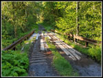 Metal Bridge |
 Snowy Ridge Above |
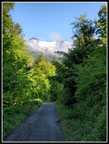
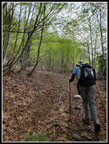
 Road Walk |
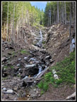
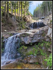 Washout Falls |
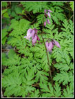 Bleeding Hearts |
 Another Washout Spot |
 Off The Main Road |
 Views Out |
 Clouds & Russian Butte |
 Up Snowy Road |
 Long Traverse |
 Looking Back |
 Mt. Rainier |
 Off Road Climbing |
 Heading Higher |
 Steeper |
 Green Mountain |
 Looking East To Crest |
 Gary Nears Summit |
 Mt. Baker & 3 Fingers |
 Gary On Real Summit |
 Kaleetan & Chair Peak |
 Gary & Crest Peaks |
 Garfield & Hinman |
 Teneriffe Summit |
 Moolock Mountain |
 Jim On The Summit |
 Mailbox Peak |
 Pouring Over Saddle |
 Gary Looking West |
 Sun & Clouds |
 Moody Clouds |
 Cloudy Hinman |
 Cloudy Crest |
 Descent Route |
 Gary Descending |
 Jim Descending |
 Thunderhead |
 More Photos |
 Back On Traverse |
 Russian Butte Again |
 Cairn Land |
 Bunchberry |
 Back To Washouts |
 Washout Waterfall |
 Blowout Creek Bridge |
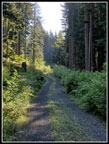
 Green Road Walk |
 Oxbow Trail |
Trips - 2021
Home