7-11-21
Gary
was free for a Sunday hike and
he suggested Point 5591 on the ridge to Suntop Lookout He suggested
naming it MoonTop. It is 311' higher than Suntop though it has no
lookout building on top. Most folks go to Suntop by driving the road to
the summit or if the gate is looked to within a mile or so of the top.
The trail to Suntop starts at 2600' near the White River and climbs a
net 3000' to Moontop before descending then climbing to Suntop. The
trail comes very near the top of MoonTop. We figured to hike there and
then go on to Suntop if we felt up to it. It would be at least 11.5
miles and over 3000' just for Moontop. We had a few early season trail
condition reports but none in several months. It might be clear sailing
or lots of down trees to clamber over. I met Gary in Kent at 6:45 am
and we headed for Highway 410. Just one week earlier Janet and I went
to nearly the same place. Our hike from Corral Pass to Noble Knob was
directly on the other side of the White River Valley. That
one was mostly out in the sunshine due to a fire having burned up most
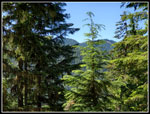
of the trees. This one would be in forest.
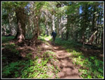
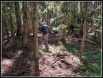
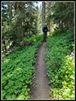
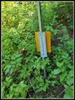
We found the trailhead opposite the Ranger Creek Emergency Airport. We were the first car in the small lot. There were a lot of folks camping on both sides of the airfield. We arrived just before 7:00 am and were on our way at 8:04 am. The route starts flat then begins to climb. This trail is open to hikers, mountain bikers, and motorcyclists. Horses are not mentioned. It then states that everyone gives the right of way to horses. The trail is too narrow much of the way on too steep a hillside to be able to pass a horse. Don't take a horse on this trail. It was hard enough to pass two wheelers on the upper trail. The day was warm enough for shorts and short sleeves from the start. Most of the way was in forest with little direct sun exposure. That was fine with me. Last week in the forest fire burned trail it was full sun almost all the way.
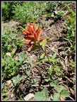
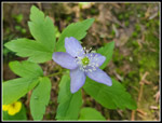
We set a fast pace for half a mile then settled in to a slower steady pace. At .60 miles the trail crosses Doe Creek. The Doe Creek Trail meets our trail here. It has a few small logs over it. I'm not sure why. I did not see any signs at that trailhead when we drove by. The creek crossing was one of only two where there was significant water still running. We gained 3600' this day but the trail was very consistently graded. Almost no roots, rocks, or steps. Easy on the legs going up and down. We had a few open spots with blooming wildflowers but not many. This is a forest hike. In many places the forest is thick enough to block out much ground cover. It did provide several types of saprophytes. We found no logs across the trail but did see a number that had been recently cut out. An advantage to a trail for motorcycles. They often cut logs in the spring and early summer.
There are several roads on the map the either cross or come very close to the trail. The first one was at 3100' and was not active. The second one came very close to the trail. We could see a motorhome from the trail. That should prove that road is open and in good shape. We soon saw two guys on motorcycles pass by. We came to the Doe Falls spur at about 2.4 miles. Not too long after that we came to the last road crossing. Now we continued climbing with no more spurs or roads before MoonTop. Well no official ones. As we neared the crossing of Buck Creek Gary mentioned the source of Buck Creek is just above the creek. The Mt. Rainier Park boundary was just a short way up the creek too. I had not realized we came so close to the park. It seemed reasonable that there might be a fisherman's trail to the lake. It sits about .60 miles and 600' higher. Lake is an overstatement too. A small lake or large pond would be more accurate. As we neared the creek we saw a boot path heading off. If we had tome and energy on the way back we would check it out.
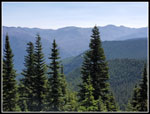
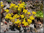
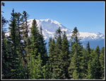
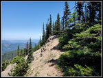
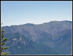
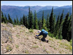
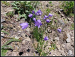
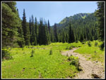
By now we had seen several folks biking down and another pair of motorcyclists. Still not a single hiker. After the creek the trail made a sharp right turn and followed below the top of the ridge heading to MoonTop and Suntop. We were already at 5000' crossing Buck Creek. Now we did some climbing and some ups and downs. Just before MooTop the trail gets very narrow and there are several switchbacks. Of course we met two motorcycles descending. It was possible to just get off the trail to let them pass. Saw tiger lilies, stonecrop, and beargrass here. The trail comes almost onto the ridge top where we headed up MoonTop. I expected a bootpath and there is not one. I guess this largely forested bump is not very popular. We slogged through some brush and over a number of logs to reach a partly open spot. Part of Mt. Rainier could be seen. There were a number of wildflowers in bloom. Higher there was an opening looking east towards Noble Knob where I was last weekend. We could see north towards the Crest peaks north of Snoqualmie Pass.
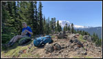
The ridge narrowed to a near point and the trail dropped to the left on a sloping route to the very top. Plentiful vegetable belay tree branches helped to get across. The top is small with a near vertical drop on that left west side. Just extremely steep on the east side. We arrived at 11:38 am. About half of Mt. Rainier was visible with trees blocking much of the other half. The mountain is only about 8 miles away from here. A real up close look at it on a clear sunny day. A path continues along a sloping route down the north side. Way to exposed for my taste though it looked like folks have trod it. We spent 37 minutes enjoying the view and hiking lunch. We packed up at 12:15 pm and headed down. We had decided by now that dropping 800' then climbing another 500' to get to Suntop Lookout in about 4.25 mils RT was not in the cards. We headed back the way we came.
The the upper trail heading back we were passed by a number of downhill biking groups. The first was I believe 7 bikers. A family of 4 more zoomed on by. Lots of bikers but not a lot of groups. We had a lot of solitude between the downhill bikers. When we reached Buck Creek we took the boot path we had seen earlier. It follows the creek a short way to signs marking the border of MRNP. The trail comes really close to the park. It continues along then drops to the creek as it exits a large meadow. We rock hopped the creek as it was flowing well. Now the creek was underground. A rocky creek bed in the meadow but no water. The trail ended. We looked left and followed a few paths that quickly ended. We headed back to the creek bed and followed that. Across the meadow the creek started climbing again. Now water started flowing again though less than back at the real trail. Moving along the trail I had hardly noticed any bugs all day. Now climbing a creek with brush all around the skeeters were getting thick. I still had shorts and short sleeves. We press on a ways looking for boot paths. We tried one right then one left. We were half way to the lake having climbed 210' but had 400' to go in a creek or in brush with no trail. We decided we had had enough. We returned to the main trail.
I was surprised to see the trail peter out so quickly. It will be a brush bash if we decide to come back. As mentioned the trail is very nicely graded. We had miles to go and 2400' of elevation to lose but the trail was good. With about 2 mils or less to go we met a group of hikers heading up. The first hikers of the day after over 11 miles hiked. We saw a few more heading up too. The first group quickly turned around and we could hear them behind but they never caught up. We reached the car at 4:25 pm. We spent 8:21 on our hike. With a few off trail spots and a long lunch we had a fair bit of time not hiking the trail. The thick forest made for a very comfortable day though it was plenty hot in the open. We had good but not spectacular views. We saw a number of folks, most on bikes, but they passed quickly and we were along nearly all day long. MoonTop is unlikely to be anyones goal from the valley bottom. Much shorter and easier from the parking area below Suntop Lookout. The trail is destined to be used mostly be a few motorcyclists and a number of mostly downhill mountain bikers. And a few folks like us who want to hike a trail that had no lakes and marginal views. It was still a fun day on a trail we had never hiked.
Click on thumbnails to get
larger pictures.
Trips - 2021
Home
We found the trailhead opposite the Ranger Creek Emergency Airport. We were the first car in the small lot. There were a lot of folks camping on both sides of the airfield. We arrived just before 7:00 am and were on our way at 8:04 am. The route starts flat then begins to climb. This trail is open to hikers, mountain bikers, and motorcyclists. Horses are not mentioned. It then states that everyone gives the right of way to horses. The trail is too narrow much of the way on too steep a hillside to be able to pass a horse. Don't take a horse on this trail. It was hard enough to pass two wheelers on the upper trail. The day was warm enough for shorts and short sleeves from the start. Most of the way was in forest with little direct sun exposure. That was fine with me. Last week in the forest fire burned trail it was full sun almost all the way.
We set a fast pace for half a mile then settled in to a slower steady pace. At .60 miles the trail crosses Doe Creek. The Doe Creek Trail meets our trail here. It has a few small logs over it. I'm not sure why. I did not see any signs at that trailhead when we drove by. The creek crossing was one of only two where there was significant water still running. We gained 3600' this day but the trail was very consistently graded. Almost no roots, rocks, or steps. Easy on the legs going up and down. We had a few open spots with blooming wildflowers but not many. This is a forest hike. In many places the forest is thick enough to block out much ground cover. It did provide several types of saprophytes. We found no logs across the trail but did see a number that had been recently cut out. An advantage to a trail for motorcycles. They often cut logs in the spring and early summer.
There are several roads on the map the either cross or come very close to the trail. The first one was at 3100' and was not active. The second one came very close to the trail. We could see a motorhome from the trail. That should prove that road is open and in good shape. We soon saw two guys on motorcycles pass by. We came to the Doe Falls spur at about 2.4 miles. Not too long after that we came to the last road crossing. Now we continued climbing with no more spurs or roads before MoonTop. Well no official ones. As we neared the crossing of Buck Creek Gary mentioned the source of Buck Creek is just above the creek. The Mt. Rainier Park boundary was just a short way up the creek too. I had not realized we came so close to the park. It seemed reasonable that there might be a fisherman's trail to the lake. It sits about .60 miles and 600' higher. Lake is an overstatement too. A small lake or large pond would be more accurate. As we neared the creek we saw a boot path heading off. If we had tome and energy on the way back we would check it out.
By now we had seen several folks biking down and another pair of motorcyclists. Still not a single hiker. After the creek the trail made a sharp right turn and followed below the top of the ridge heading to MoonTop and Suntop. We were already at 5000' crossing Buck Creek. Now we did some climbing and some ups and downs. Just before MooTop the trail gets very narrow and there are several switchbacks. Of course we met two motorcycles descending. It was possible to just get off the trail to let them pass. Saw tiger lilies, stonecrop, and beargrass here. The trail comes almost onto the ridge top where we headed up MoonTop. I expected a bootpath and there is not one. I guess this largely forested bump is not very popular. We slogged through some brush and over a number of logs to reach a partly open spot. Part of Mt. Rainier could be seen. There were a number of wildflowers in bloom. Higher there was an opening looking east towards Noble Knob where I was last weekend. We could see north towards the Crest peaks north of Snoqualmie Pass.
The ridge narrowed to a near point and the trail dropped to the left on a sloping route to the very top. Plentiful vegetable belay tree branches helped to get across. The top is small with a near vertical drop on that left west side. Just extremely steep on the east side. We arrived at 11:38 am. About half of Mt. Rainier was visible with trees blocking much of the other half. The mountain is only about 8 miles away from here. A real up close look at it on a clear sunny day. A path continues along a sloping route down the north side. Way to exposed for my taste though it looked like folks have trod it. We spent 37 minutes enjoying the view and hiking lunch. We packed up at 12:15 pm and headed down. We had decided by now that dropping 800' then climbing another 500' to get to Suntop Lookout in about 4.25 mils RT was not in the cards. We headed back the way we came.
The the upper trail heading back we were passed by a number of downhill biking groups. The first was I believe 7 bikers. A family of 4 more zoomed on by. Lots of bikers but not a lot of groups. We had a lot of solitude between the downhill bikers. When we reached Buck Creek we took the boot path we had seen earlier. It follows the creek a short way to signs marking the border of MRNP. The trail comes really close to the park. It continues along then drops to the creek as it exits a large meadow. We rock hopped the creek as it was flowing well. Now the creek was underground. A rocky creek bed in the meadow but no water. The trail ended. We looked left and followed a few paths that quickly ended. We headed back to the creek bed and followed that. Across the meadow the creek started climbing again. Now water started flowing again though less than back at the real trail. Moving along the trail I had hardly noticed any bugs all day. Now climbing a creek with brush all around the skeeters were getting thick. I still had shorts and short sleeves. We press on a ways looking for boot paths. We tried one right then one left. We were half way to the lake having climbed 210' but had 400' to go in a creek or in brush with no trail. We decided we had had enough. We returned to the main trail.
I was surprised to see the trail peter out so quickly. It will be a brush bash if we decide to come back. As mentioned the trail is very nicely graded. We had miles to go and 2400' of elevation to lose but the trail was good. With about 2 mils or less to go we met a group of hikers heading up. The first hikers of the day after over 11 miles hiked. We saw a few more heading up too. The first group quickly turned around and we could hear them behind but they never caught up. We reached the car at 4:25 pm. We spent 8:21 on our hike. With a few off trail spots and a long lunch we had a fair bit of time not hiking the trail. The thick forest made for a very comfortable day though it was plenty hot in the open. We had good but not spectacular views. We saw a number of folks, most on bikes, but they passed quickly and we were along nearly all day long. MoonTop is unlikely to be anyones goal from the valley bottom. Much shorter and easier from the parking area below Suntop Lookout. The trail is destined to be used mostly be a few motorcyclists and a number of mostly downhill mountain bikers. And a few folks like us who want to hike a trail that had no lakes and marginal views. It was still a fun day on a trail we had never hiked.
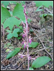
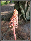 Pinedrop |
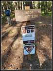 Trail Sign |
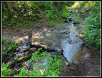
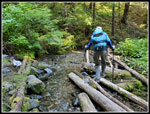 Crossing Doe Creek |
 Saprophyte |
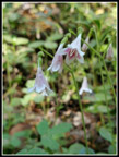 Twinflower |
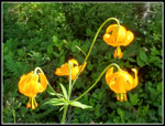 Tiger Lilies |
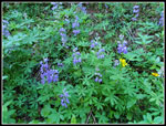 Lupine |
 Coralroot |
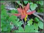 Columbine |
 Buck Creek |
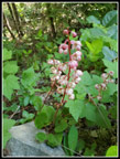
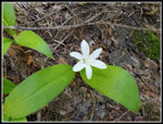 Queen's Cup |
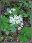 Valerian |
 View Out |
 Stonecrop |
 Bear Grass |
 Near The Ridge |
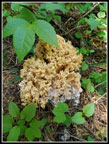 Fungus |
 View South |
 View North |
 Mt. Stuart |
 Mt. Rainier |
 Me On The Summit |
 Scramble Spot |
 Corral Pass Area |
 Off Trail |
 Gary At Work |
 Harebells |
 Orange Paintbrush |
 Vanilla Leaf |
 MRNP Boundary |
 Oregon Anemone |
 Big Meadow |
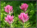 Magenta Paintbrush |
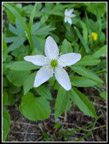 White Anemone |
 MoonTop Summit |
Trips - 2021
Home