5-08-21
Gary
was free for a hike. With a
chance of rain on the west side and high winds on the east side of the
mountains we chose moisture. We hoped to get in some longer miles and
avoid crowds. Where else to find solitude than Wallace Falls State
Park? We arrived early by 7:38 am. The lot was filling but still mostly
empty. I had a few short rain showers on the drive over but it was dry
when we set out at 7:42 am. We quickly decided to do the falls lakes
loop going counterclockwise. This would get us past the busy falls
trail before the crowds arrived. With Sunday being Mothers Day I
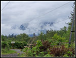
figured it might be even more crowded this day. At the Index - Baring
viewpoint we had nothing but clouds. On the the junction. We went right
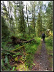
on the Woody Trail. I hardly ever hike this trail as the Railroad Grade
is longer but we had plenty of miles planned.
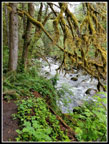
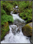
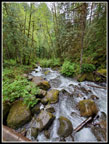
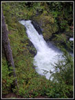
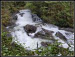
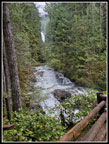
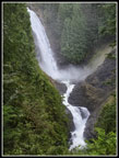
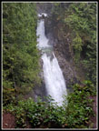
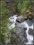
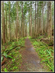
Along the Woody Trail we did pass a few groups going up and coming down. About what you would expect every few minutes by 11:00 am. The Wallace River had a good sized flow. Perhaps the waterfalls would be a great show. We were making good time. Few folks to pass and a nice cool morning. Damp and in the low 40s. After climbing to the roofed picnic spot we left the trail to check out the views of the lower falls. Not too bad at all. We were soon back on the trail. The middle falls looked especially good with lots of mist blowing away from the foot of the falls. Higher we went reaching the bottom of the upper falls at 8:56 am. The 2.5 miles took us 1:14 including the photo stops. Two women were at the upper falls when we arrived and they headed up the bootpath to the upper road. After photos we followed them.
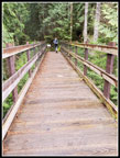
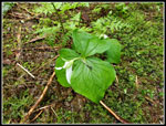
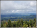
The reached the top just ahead of us and turned left towards Wallace Lake. We turned right heading for the newish bridge and did not see them again. We crossed the bridge and took a short break. Some trillium were still in bloom. A few photos from the bridge and we headed on towards Wallace Lake. At the first clear cut viewpoint the clouds were too thick to see much of anything. The peaks and Skykomish Valley were lost in a sea of white. On we went. At one point a new road was met and it is much larger than the old road. A sign points out the right turn to stay on route. If it disappears some folks will take the wrong route. It will not go directly to Wallace Lake but it must reach the top of the Greg Ball Trail. The old road has been decommissioned. There are quite a few removed culverts that now require dropping down and stepping back up to cross. Understandable, but not as much fun to hike.
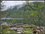
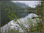
The ditches along the road had a good flow of water in places. That did not bode well for the spot just before reaching Wallace Lake. In the winter and spring water runs over the road trail and is often deep enough to hard to cross. On one occasion the water was running down the road 100+ feet from the usual water flowing over the road. Rocks have now been placed on one side of the road/trail but the crossing itself can be knee deep. Much to my surprise the water was mostly just a big puddle before the crossing and even that was just a rock and short log hop. No problem at all. We had seen some yellow violets and trillium along the road and skunk cabbage near the crossing. Not a lot but some wildflower colors. We reached the outlet bridge for Wallace Lake at 10:03 am. We had hiked 5.3 miles in 2:21. A decent speed and it was still just past 10:00 am.
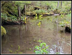
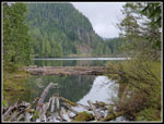
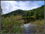
After a quick break we headed on around the lake. When I was at the lake in March the water level was quite low. I went far out at Pebble Beach and took a long break on the shore. As we headed around the lake it became clear that the water level was much higher. At the far end the inlet stream was dry in March. Now it was full of water. We crossed and took and overland route around most of the devil's club to the shore near the inlet. There was no Pebble Beach. The water was several feet higher than on my earlier visit. The log I sat on then was mostly underwater now. With no place for a break we took off for Jay Lake. Jay is just a mile away. The bit of snow in March was long gone now and we sped on to the lake. At Jay Lake we went down to the shore. The lake was now too high to get out far enough for a clear look. We could just see a little of the lake.
We stopped at the picnic table but decided a wet table in a dark forest was not the place for lunch. We headed back to Wallace Lake. It is not too unusual to see a person between Wallace and Jay Lakes. Two groups would be unusual. We saw three or four groups in just a few minutes. That was very unusual. From the upper falls to Wallace and Jay Lakes we passed just one person. Still, compared to the 10 dozen groups at the falls by this time of day it was pretty minor. We went around Wallace Lake and where the old road comes in we went out a short way to get out of the forest. Now it was finally lunch time. It was now 11:11 am. We had hiked 8.3 miles in 3:29. Not a bad time and it was still well before noon. Much to our surprise some big blue sucker holes started to appear. Where the sun shone through it as almost warm. We carried umbrellas as showers were forecast for the early afternoon but it was looking pretty good.
Gary received a text from home stating it was raining. We ran away to the mountains to escape the rain. That is seldom the case. Views were not great but we could see the valley below and most of the ridge to the south. Even pars of Mts. Index and Persis cleared up. Our lunch break lasted until 11:48 am when darker clouds rolled overhead. We still had quite a distance to go so we packed up and headed back. Around the the Wallace Lake outlet and then on the road trail back to the main logging road. A group left the lake just before us at a good speed and we stayed right with them. We quickly reached the main road and turned right while the other group stopped. We had earlier discussed two options down from here. The dark forested and somewhat popular Greg Ball Trail of the longer out in the open main road. A small and a large group were at the start of the Greg Ball Trail and Gary decided it would be the road on the way down. That meant our day would be around 15 miles. This would be Gary's longest trip since injuring his knee late last summer and rehabbing it through the fall.
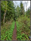
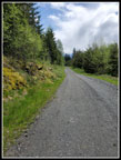
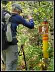
I had mentioned more than a few times that the road is empty of people and at a steady grade that is very good for fast hiking. We blasted by the groups at the Greg Ball Trail and really never slowed down. We hiked the 6.7 miles down form Wallace Lake at an average pace of 3.5 mph. That is well above average for a couple old guys. From Greg Ball down to the Railroad Grade Trail we saw nobody. Another day of solitude at one of the most popular state parks in the area. The sun did come partly back out and the road proved much warmer than the forest trail would have been. Where we left the road for trail I pointed out the Rake Trail sign to Gary. It seems to show that the trail is open to hikers who carry a rake. We did not and managed to get through unnoticed.
While we did pass a number of folks on the grade it was not crowded. We reached the trailhead at 1:50 pm. Every parking space was taken with folks just sitting in their cars waiting for someone to leave so they could park. Pretty normal for a weekend afternoon at Wallace Falls State Park. For a fall back hike when high winds or rain threatened most of the state this one turned out great. We were able to see the falls with quite a lot of water coming over them and before the crowds. Near total solitude over to Wallace and Jay Lakes and some sunshine during our lunch break. Our trip down form the falls was very quick. At about 17.5 minutes per mile the miles flew by. By early afternoon we completed a 15.3 mile day with 2300' of elevation gain. Not a bad way to spend a cool overcast spring day.
Click on thumbnails to get
larger pictures.
Trips - 2021
Home
Along the Woody Trail we did pass a few groups going up and coming down. About what you would expect every few minutes by 11:00 am. The Wallace River had a good sized flow. Perhaps the waterfalls would be a great show. We were making good time. Few folks to pass and a nice cool morning. Damp and in the low 40s. After climbing to the roofed picnic spot we left the trail to check out the views of the lower falls. Not too bad at all. We were soon back on the trail. The middle falls looked especially good with lots of mist blowing away from the foot of the falls. Higher we went reaching the bottom of the upper falls at 8:56 am. The 2.5 miles took us 1:14 including the photo stops. Two women were at the upper falls when we arrived and they headed up the bootpath to the upper road. After photos we followed them.
The reached the top just ahead of us and turned left towards Wallace Lake. We turned right heading for the newish bridge and did not see them again. We crossed the bridge and took a short break. Some trillium were still in bloom. A few photos from the bridge and we headed on towards Wallace Lake. At the first clear cut viewpoint the clouds were too thick to see much of anything. The peaks and Skykomish Valley were lost in a sea of white. On we went. At one point a new road was met and it is much larger than the old road. A sign points out the right turn to stay on route. If it disappears some folks will take the wrong route. It will not go directly to Wallace Lake but it must reach the top of the Greg Ball Trail. The old road has been decommissioned. There are quite a few removed culverts that now require dropping down and stepping back up to cross. Understandable, but not as much fun to hike.
The ditches along the road had a good flow of water in places. That did not bode well for the spot just before reaching Wallace Lake. In the winter and spring water runs over the road trail and is often deep enough to hard to cross. On one occasion the water was running down the road 100+ feet from the usual water flowing over the road. Rocks have now been placed on one side of the road/trail but the crossing itself can be knee deep. Much to my surprise the water was mostly just a big puddle before the crossing and even that was just a rock and short log hop. No problem at all. We had seen some yellow violets and trillium along the road and skunk cabbage near the crossing. Not a lot but some wildflower colors. We reached the outlet bridge for Wallace Lake at 10:03 am. We had hiked 5.3 miles in 2:21. A decent speed and it was still just past 10:00 am.
After a quick break we headed on around the lake. When I was at the lake in March the water level was quite low. I went far out at Pebble Beach and took a long break on the shore. As we headed around the lake it became clear that the water level was much higher. At the far end the inlet stream was dry in March. Now it was full of water. We crossed and took and overland route around most of the devil's club to the shore near the inlet. There was no Pebble Beach. The water was several feet higher than on my earlier visit. The log I sat on then was mostly underwater now. With no place for a break we took off for Jay Lake. Jay is just a mile away. The bit of snow in March was long gone now and we sped on to the lake. At Jay Lake we went down to the shore. The lake was now too high to get out far enough for a clear look. We could just see a little of the lake.
We stopped at the picnic table but decided a wet table in a dark forest was not the place for lunch. We headed back to Wallace Lake. It is not too unusual to see a person between Wallace and Jay Lakes. Two groups would be unusual. We saw three or four groups in just a few minutes. That was very unusual. From the upper falls to Wallace and Jay Lakes we passed just one person. Still, compared to the 10 dozen groups at the falls by this time of day it was pretty minor. We went around Wallace Lake and where the old road comes in we went out a short way to get out of the forest. Now it was finally lunch time. It was now 11:11 am. We had hiked 8.3 miles in 3:29. Not a bad time and it was still well before noon. Much to our surprise some big blue sucker holes started to appear. Where the sun shone through it as almost warm. We carried umbrellas as showers were forecast for the early afternoon but it was looking pretty good.
Gary received a text from home stating it was raining. We ran away to the mountains to escape the rain. That is seldom the case. Views were not great but we could see the valley below and most of the ridge to the south. Even pars of Mts. Index and Persis cleared up. Our lunch break lasted until 11:48 am when darker clouds rolled overhead. We still had quite a distance to go so we packed up and headed back. Around the the Wallace Lake outlet and then on the road trail back to the main logging road. A group left the lake just before us at a good speed and we stayed right with them. We quickly reached the main road and turned right while the other group stopped. We had earlier discussed two options down from here. The dark forested and somewhat popular Greg Ball Trail of the longer out in the open main road. A small and a large group were at the start of the Greg Ball Trail and Gary decided it would be the road on the way down. That meant our day would be around 15 miles. This would be Gary's longest trip since injuring his knee late last summer and rehabbing it through the fall.
I had mentioned more than a few times that the road is empty of people and at a steady grade that is very good for fast hiking. We blasted by the groups at the Greg Ball Trail and really never slowed down. We hiked the 6.7 miles down form Wallace Lake at an average pace of 3.5 mph. That is well above average for a couple old guys. From Greg Ball down to the Railroad Grade Trail we saw nobody. Another day of solitude at one of the most popular state parks in the area. The sun did come partly back out and the road proved much warmer than the forest trail would have been. Where we left the road for trail I pointed out the Rake Trail sign to Gary. It seems to show that the trail is open to hikers who carry a rake. We did not and managed to get through unnoticed.
While we did pass a number of folks on the grade it was not crowded. We reached the trailhead at 1:50 pm. Every parking space was taken with folks just sitting in their cars waiting for someone to leave so they could park. Pretty normal for a weekend afternoon at Wallace Falls State Park. For a fall back hike when high winds or rain threatened most of the state this one turned out great. We were able to see the falls with quite a lot of water coming over them and before the crowds. Near total solitude over to Wallace and Jay Lakes and some sunshine during our lunch break. Our trip down form the falls was very quick. At about 17.5 minutes per mile the miles flew by. By early afternoon we completed a 15.3 mile day with 2300' of elevation gain. Not a bad way to spend a cool overcast spring day.
 Mt. Index View |
 Wallace River |
 Upriver From Bridge |
 Downriver |
 Lower Falls |
 Cascades |
 Distant Middle Falls |
 Middle Falls |
 Upper Falls |
 Above Upper Falls |
 Bridge At Top |
 Trillium |
 No View Viewpoint |
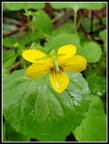 Yellow Violet |
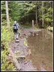 Big Puddle |
 Skunk Cabbage |
 Wallace Lake Outlet |
 Wallace Lake Again |
 Underwater Beach |
 Jay Lake |
 Narrow Trail |
 Trail From Jay Lake |
 Another Non Viewpoint |
 On The Road Again |
 Rake Trail |
 More Lonesome Trail |
Trips - 2021
Home