11-20-21
We
had snow below pass level during the week following serious flooding on
Monday. I wanted to get in some longer mileage since I had only 23
miles so far this month. The answer was a lower elevation trip. I
reached the trailhead at 8:25 am. The lot was a little less than half
full. I was on my way at 8:34 am. It was just under 40 degrees. The
downside of this trip is it has several sections on active logging
roads and old railroad grades. I have had plantar fasciitis the past
few months and especially hard surfaces make walking painful. I decided
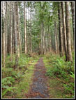
to go up the Woody Trail. I saw several groups already coming down. I
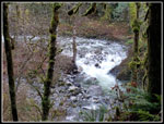
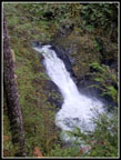
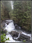
passed a couple of slower groups going up. Small Falls had lots of
water.
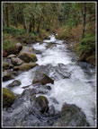
I dropped down to the bridge over the river. Lots of water passing by
but not super high. That boded well for the one difficult water
crossing just before Wallace Lake.
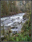
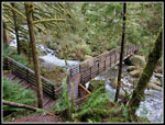
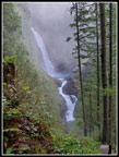
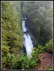
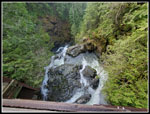
I climbed up to the covered picnic shelter and had my first look at the lower falls. Plenty of water had them looking really good. A couple of other groups were there too. I took a number of photos and headed out before the other groups. The middle falls looked really good. I reached the upper falls ahead of a group of half a dozen. Not my favorite view and I was soon on my way. Heading up the bootpath to the road above I met a couple on this route for the first time. I passed by and they reached the top just after me. They were looking for the new bridge. It was finished several years ago but few folks go over to where it is located. I showed the folks the bridge. They headed back and I checked out the old roads on the other side. In time, the trails from Reiter will reach this spot. Until then there is not much to see. Someone has cut out a few logs.
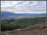
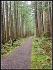
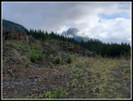
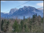
I headed back to the road and started on my way to Wallace Lake. A short way along is the logging landing from logging less than a decade ago. Good views out of the Skykomish River Valley. It was still quite cloudy. I could see some snow on the peaks across the valley. A few photos and I was back on my way. The several miles of road is not the highlight of the trip. Years back, the road was narrow and grassy making for a near trail. Now it is wide and heavily graveled making for sore feet. A few folks do travel over to the lake but most just go to the lake or the falls. Lots of solitude in between. A trip report just a few days earlier mentioned the new logging would be starting on this date. Beware of logging equipment on the roads. I have not seen any weekend logging on DNR land and did not see any this day.
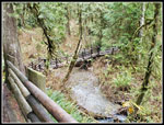
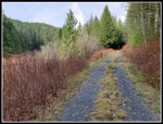
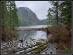
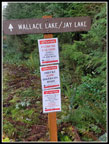
A new road was there on my previous visit this year. A small sign shows the trail follows the smaller road that goes off to the right. I soon reached the "T" junction. Left goes around to the top of the Greg Ball Trail on the logging road. Right goes to another recently logged area. Right also goes to Wallace Lake. This route has a spot before the lake where water rushes over the road/trail. One time it was so deep I had to turn around and take the road over to the Greg Ball Trail. I wore high top boots to help get across the bad spot. Water can cover the road for more than a hundred feet before the actual water crossing. A few years ago flat rocks were placed on the right edge of the road. These work pretty well for most of the way. The deep crossing is at the end of the rocks. There was much less water on the road/trail here than I expected.
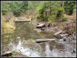
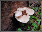
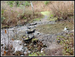
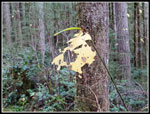
I walked along the rocks to the bad spot and noticed that a small new bridge has been laid across the road to get to the left side. A few steps on muddy soil and another short bridge leads to the last spot. There are sort logs and with my poles I was able to get from one to the other without dunking my boots. Mission accomplished. It is a significant improvement. Now I just had a short walk to Wallace Lake. Years back and before my time cars drove to Wallace Lake. There was a small campground to the right of the lake. The camping sign is still thee. Backpacking to Jay Lake has been available for several years with reserved campsites. I read the night before that there is camping at Wallace Lake too. Decades back I followed the road to the right of the lake looking for the old campgrounds and found nothing. This day I decided to take another look. I found one official campsite and an outhouse. I followed a trail to the lakeshore. There is a pretty good look at the lake. I saw some neat mushrooms along there also.
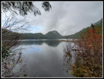
I was in some brief bright sunshine on the road from the falls and nearing the lake it became dark and cold. Cold enough for gloves. It now also began to rain lightly. I brought an umbrella but decided not to take in on the hike as radar showed morning rain was entirely gone when I started hiking. On went my rain gear. I headed over to the outlet bridge and had a view down the lake with clouds not far above. I continued around the lake. Just before the inlet, I stopped at a bench just above the lake. The lake was very high and I could see that Pebble Beach at the inlet was underwater. I stopped at the bench for lunch. Well, I stopped behind the bench in trees where it was not wet. I have been to the lake when it was snowy but seldom when it is raining. I checked out my mileage and decided I needed to go partway to Jay Lake it get up to an even 13 miles. After my lunch break, I headed to the inlet.
Many years back the park folks placed four big round plastic/rubber "pots" in the inlet creek. They filled them with rocks. They have worked quite well as a means to get across the creek. I went across and back with dry boots. The old road to Jay Lake starts with a climb then is nearly flat most of the way. When the water is this high it is not possible to get down to the shore of Jay. I had no great reason to push on. My heel was already getting sore and I had a lot of miles to go. About 2/3s of the way I turned around and headed back to Wallace Lake. I saw folks near the outlet of Wallace but not beyond. Another reason for turning around before the lake is that I started at 8:34 am and sunset would be just under eight hours later. I hoped to get home before dark. The days are getting very short.
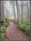
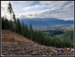
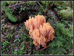
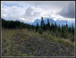
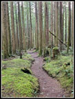
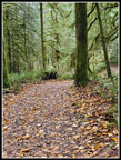
On my way around the lake, I took a detour to a view of the valley from recent logging. I had clearer skies than in the morning though there were still clouds to be seen. The hike back from Wallace Lake was 5+ miles of rocky road, nice trail, and hard packed railroad grade. In every trip report, I complain about the sharp rocks on the road from the main road to the lake. It is especially awful if you have plantar and a sore heel. By contrast, the main logging road was much better on my foot. The Greg Ball Trail is nice hiking. I have seen some spectacular mushrooms this time of year. Not this day. A few but no great show. I saw two folks near the top of the Greg Ball and nobody else on the trail. The last 2+ miles on the railroad grade was not much fun. I got in 13 miles without difficult creek crossings or deep fresh snow but paid the price with uncomfortably hard surfaces. I made it back to the parking lot at 3:17 pm. That was 1:10 before sunset. Traffic was not too bad but I did not get home before dark.
A little pain aside, this was a very nice hike. The falls were flowing well and not that crowded. The lake was near total solitude. The hike down had few folks seen until the last two miles and not bad then. It rained but not hard and not for very long. Considering the wild weather the past few weeks these were great hiking conditions. All in all, it was a really nice late fall hike.
Click on thumbnails to get
larger pictures.
Trips - 2021
Home
I climbed up to the covered picnic shelter and had my first look at the lower falls. Plenty of water had them looking really good. A couple of other groups were there too. I took a number of photos and headed out before the other groups. The middle falls looked really good. I reached the upper falls ahead of a group of half a dozen. Not my favorite view and I was soon on my way. Heading up the bootpath to the road above I met a couple on this route for the first time. I passed by and they reached the top just after me. They were looking for the new bridge. It was finished several years ago but few folks go over to where it is located. I showed the folks the bridge. They headed back and I checked out the old roads on the other side. In time, the trails from Reiter will reach this spot. Until then there is not much to see. Someone has cut out a few logs.
I headed back to the road and started on my way to Wallace Lake. A short way along is the logging landing from logging less than a decade ago. Good views out of the Skykomish River Valley. It was still quite cloudy. I could see some snow on the peaks across the valley. A few photos and I was back on my way. The several miles of road is not the highlight of the trip. Years back, the road was narrow and grassy making for a near trail. Now it is wide and heavily graveled making for sore feet. A few folks do travel over to the lake but most just go to the lake or the falls. Lots of solitude in between. A trip report just a few days earlier mentioned the new logging would be starting on this date. Beware of logging equipment on the roads. I have not seen any weekend logging on DNR land and did not see any this day.
A new road was there on my previous visit this year. A small sign shows the trail follows the smaller road that goes off to the right. I soon reached the "T" junction. Left goes around to the top of the Greg Ball Trail on the logging road. Right goes to another recently logged area. Right also goes to Wallace Lake. This route has a spot before the lake where water rushes over the road/trail. One time it was so deep I had to turn around and take the road over to the Greg Ball Trail. I wore high top boots to help get across the bad spot. Water can cover the road for more than a hundred feet before the actual water crossing. A few years ago flat rocks were placed on the right edge of the road. These work pretty well for most of the way. The deep crossing is at the end of the rocks. There was much less water on the road/trail here than I expected.
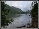
I walked along the rocks to the bad spot and noticed that a small new bridge has been laid across the road to get to the left side. A few steps on muddy soil and another short bridge leads to the last spot. There are sort logs and with my poles I was able to get from one to the other without dunking my boots. Mission accomplished. It is a significant improvement. Now I just had a short walk to Wallace Lake. Years back and before my time cars drove to Wallace Lake. There was a small campground to the right of the lake. The camping sign is still thee. Backpacking to Jay Lake has been available for several years with reserved campsites. I read the night before that there is camping at Wallace Lake too. Decades back I followed the road to the right of the lake looking for the old campgrounds and found nothing. This day I decided to take another look. I found one official campsite and an outhouse. I followed a trail to the lakeshore. There is a pretty good look at the lake. I saw some neat mushrooms along there also.
I was in some brief bright sunshine on the road from the falls and nearing the lake it became dark and cold. Cold enough for gloves. It now also began to rain lightly. I brought an umbrella but decided not to take in on the hike as radar showed morning rain was entirely gone when I started hiking. On went my rain gear. I headed over to the outlet bridge and had a view down the lake with clouds not far above. I continued around the lake. Just before the inlet, I stopped at a bench just above the lake. The lake was very high and I could see that Pebble Beach at the inlet was underwater. I stopped at the bench for lunch. Well, I stopped behind the bench in trees where it was not wet. I have been to the lake when it was snowy but seldom when it is raining. I checked out my mileage and decided I needed to go partway to Jay Lake it get up to an even 13 miles. After my lunch break, I headed to the inlet.
Many years back the park folks placed four big round plastic/rubber "pots" in the inlet creek. They filled them with rocks. They have worked quite well as a means to get across the creek. I went across and back with dry boots. The old road to Jay Lake starts with a climb then is nearly flat most of the way. When the water is this high it is not possible to get down to the shore of Jay. I had no great reason to push on. My heel was already getting sore and I had a lot of miles to go. About 2/3s of the way I turned around and headed back to Wallace Lake. I saw folks near the outlet of Wallace but not beyond. Another reason for turning around before the lake is that I started at 8:34 am and sunset would be just under eight hours later. I hoped to get home before dark. The days are getting very short.
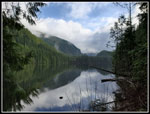
On my way around the lake, I took a detour to a view of the valley from recent logging. I had clearer skies than in the morning though there were still clouds to be seen. The hike back from Wallace Lake was 5+ miles of rocky road, nice trail, and hard packed railroad grade. In every trip report, I complain about the sharp rocks on the road from the main road to the lake. It is especially awful if you have plantar and a sore heel. By contrast, the main logging road was much better on my foot. The Greg Ball Trail is nice hiking. I have seen some spectacular mushrooms this time of year. Not this day. A few but no great show. I saw two folks near the top of the Greg Ball and nobody else on the trail. The last 2+ miles on the railroad grade was not much fun. I got in 13 miles without difficult creek crossings or deep fresh snow but paid the price with uncomfortably hard surfaces. I made it back to the parking lot at 3:17 pm. That was 1:10 before sunset. Traffic was not too bad but I did not get home before dark.
A little pain aside, this was a very nice hike. The falls were flowing well and not that crowded. The lake was near total solitude. The hike down had few folks seen until the last two miles and not bad then. It rained but not hard and not for very long. Considering the wild weather the past few weeks these were great hiking conditions. All in all, it was a really nice late fall hike.
 Wallace River |
 First Bridge |
 Looking Downstream |
 Catching Up |
 Big Bridge |
 NF Wallace River |
 Mossy Branches |
 Lower Falls |
 Cascades |
 Middle Falls |
 Upper Falls |
 Above Upper Falls |
 Logging Viewpoint |
 Peaks In Clouds |
 Road To Lake |
 New Bridges |
 Forest To Lake |
 Mushrooms |
 Colorful Fungus |
 Wallace Lake View |
 Lake From Inlet Bridge |
 Dark Lake Near Inlet |
 Clearing Up |
 Creek Crossing Pots |
 Path To Jay Lake |
 Logging Viewpoint II |
 Still Cloudy |
 Hikers Beware! |
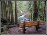 Bench Above River |
 Mossy Ground |
 Hanging On |
 Fallen Leaves |
 Index & Persis |
Trips - 2021
Home