09-24-22
John
was free for a Saturday hike. Highway 2 was still closed by the Bolt
Fire. Westbound I90 was closed all weekend across Mercer Island to
Seattle. We had to go north or south. North it was. Last weekend we had
a long drive and a 4000' ascent on the Sahale Arm Trail. This time we
opted for a shorter drive and another 4000' gain to a great viewpoint
atop Mt. Dickerman. We slept in later this week and met at the Ash Way
P&R at 6:45 am. The drive up the Mountain Loop Highway was easy
enough until we ran into a long line of cars just before the Dickerman
Trailhead. Only one car turned in. The rest continued on towards Barlow
Pass. There were 6-8 cars in the lot. Definitely not crowded yet. We
arrived at 7:40 am and were on the trail at 7:50 am. One guy started
shortly before us. A large group looked to be about to get started.
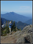
The forecast had 70& overcast at 6:00 am dropping to 25% at 10:00 am. We started out under bright blue sky. A forecast error in our favor. The first quarter mile gains elevation slowly until a switchback where the old trail comes in. Behind the branches covering it, it still looks pretty good. Now the trail gets down to business. Many many switchbacks at a steady fairly steep grade. It is a bit rocky near the bottom but gets better. It was 50 degrees and a bit chilly at the start. When we reached the flat switchback where I often shed a layer I took off pants legs and switched to a short sleeve shirt. That was much better. We had nearly caught up with the lone hiker but he pulled away when we stopped. We expected some of the big group of young hikers would pass us by. They did not.
The first half of the hike is mostly the same. Steady climbing with many switchbacks and no views out, There used to be one view spot but the trees have grown too tall. We did catch and pass one group of two hikers. There is a metal 2 mile marker and try as I might to see it, I missed it. The 2 miles is from the old trailhead. It is now about 2.25 miles. That makes it roughly the half way point. Soon after, we reached the first view out. We could see Hall Peak and Big Four Mountain. There was a little fall color too. I generally take photos all along the route. I only had 2 photos up to the viewpoint. It might be a record low. I finished with 136. Things improved markedly. We passed the empty creek and the two switchbacks and headed towards the meadows. The flower show consisted of pearly everlasting, some far past prime asters, and nearly finished fireweed. That was it.
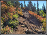
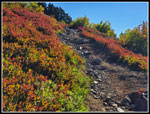
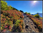
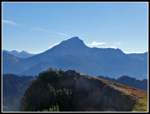
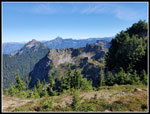
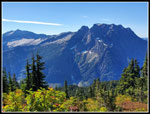
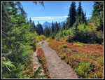
The start of the meadows means steep stairs and lots of big sharp gravel. This is my least favorite part though it is not long. We did find some huckleberries that were ripe and sweet. Most were fairly small. The meadow led to the ridge top and a couple views over to Stillaguamish Peak and the ridge over to Mt. Forgotten. That ridge is berry bushes and lots of fall colors. The trail climbs and traversed to beneath the summit. Here we stopped for some fall color photos and great views south to Del Campo, Morningstar, Sperry, Vesper, Big Four and Hall peaks. We finally passed the lone hiker here. The last climb is on a colorful slope with red and orange colors. Two younger hikers passed by us. That made it three hikers we passed and two passed us all the way up. We had almost total solitude on Mt. Dickerman on a sunny fall day. That was unexpected.
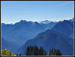
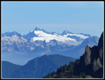
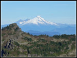
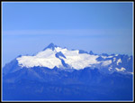
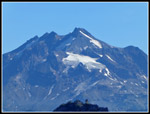
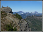
We reached the top at 10:19 am. We took 2:29 with many photo stops the last mile. There were 3 people on top. Two of them had just passed us. I expected more hikers, even that early. I feared some smoke haze to the north but it was clear. Looking back at my past reports, it was a decade earlier that I last had no clouds blocking any views. Dickerman provides some really great mountain views. Much better than the 5728' summit would suggest. Three volcanoes with Mt. Baker, Glacier Peak, and Mt. Rainier visible. With my maximum zoom lens I cold see the lookout atop Three Fingers. There was haze in the valleys to the south but the peaks were in the clear. We have had some bad smoke in Seattle the past week but the wind was blowing to the east this day. I had breakfast at 5:40 am and it felt like time for an early lunch.
Hikers left and a some more came up . It was never close to being crowded. After an hour, we headed to the next lower summit point. From there we could see down to a big valley. Gary and I saw a bear there a few years back. Not his year. We dropped down to a small tower. I have no idea of it's purpose. We climbed back up and went back to the highest point again. Time for one last look at all the mountains in sight. We packed up and headed down at 12:10 pm. We had a nice long 1:51 on the summit. The first mile down provided more photo opportunities then we dropped into forest and just concentrated on all the elevation loss. We saw small groups coming up but not as many as I expected on such a nice day. With Highway 2 closed and I-90 a mess reaching Seattle I expected a lot more people at Mt. Dickerman. Not that I am complaining.
After 4000' of descent last Sunday, another 4000' was a bit of a knee cruncher. This was only my fifth 4000' gain hike of the year and four of them have been in the last four weeks. I did find the 2 mile marker on the way down. The last two miles seemed to take forever. I was glad when we reached the bottom. A lot of clouds came in on our descent. It was 70 degrees and comfortable. We finished at 2:08 pm. We came down in 1:58. The drive back was easy to Lynnwood. The last few miles had slow downs for me and John had to be creative to avoid backed up freeways getting through Bellevue.
This was a really good choice on this day. We had much clearer sky than forecast. Dickerman has few nearby peaks to block views. It really is a great location. The fall color was not at peak but was still very good. The lack of a crowd was puzzling but gladly accepted. The warm weather and consistently clear sky will be coming to an end soon. The last two weeks John and I have climbed high for some really spectacular views while enjoying fall colors. I hope there will be a few more trips like these this year. For the day, including dropping down to the tower, we hiked almost 9 miles with 4000' of elevation gain.
Click
on thumbnails to get
larger pictures.
Trips - 2022
Home
The forecast had 70& overcast at 6:00 am dropping to 25% at 10:00 am. We started out under bright blue sky. A forecast error in our favor. The first quarter mile gains elevation slowly until a switchback where the old trail comes in. Behind the branches covering it, it still looks pretty good. Now the trail gets down to business. Many many switchbacks at a steady fairly steep grade. It is a bit rocky near the bottom but gets better. It was 50 degrees and a bit chilly at the start. When we reached the flat switchback where I often shed a layer I took off pants legs and switched to a short sleeve shirt. That was much better. We had nearly caught up with the lone hiker but he pulled away when we stopped. We expected some of the big group of young hikers would pass us by. They did not.
The first half of the hike is mostly the same. Steady climbing with many switchbacks and no views out, There used to be one view spot but the trees have grown too tall. We did catch and pass one group of two hikers. There is a metal 2 mile marker and try as I might to see it, I missed it. The 2 miles is from the old trailhead. It is now about 2.25 miles. That makes it roughly the half way point. Soon after, we reached the first view out. We could see Hall Peak and Big Four Mountain. There was a little fall color too. I generally take photos all along the route. I only had 2 photos up to the viewpoint. It might be a record low. I finished with 136. Things improved markedly. We passed the empty creek and the two switchbacks and headed towards the meadows. The flower show consisted of pearly everlasting, some far past prime asters, and nearly finished fireweed. That was it.
The start of the meadows means steep stairs and lots of big sharp gravel. This is my least favorite part though it is not long. We did find some huckleberries that were ripe and sweet. Most were fairly small. The meadow led to the ridge top and a couple views over to Stillaguamish Peak and the ridge over to Mt. Forgotten. That ridge is berry bushes and lots of fall colors. The trail climbs and traversed to beneath the summit. Here we stopped for some fall color photos and great views south to Del Campo, Morningstar, Sperry, Vesper, Big Four and Hall peaks. We finally passed the lone hiker here. The last climb is on a colorful slope with red and orange colors. Two younger hikers passed by us. That made it three hikers we passed and two passed us all the way up. We had almost total solitude on Mt. Dickerman on a sunny fall day. That was unexpected.
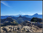
We reached the top at 10:19 am. We took 2:29 with many photo stops the last mile. There were 3 people on top. Two of them had just passed us. I expected more hikers, even that early. I feared some smoke haze to the north but it was clear. Looking back at my past reports, it was a decade earlier that I last had no clouds blocking any views. Dickerman provides some really great mountain views. Much better than the 5728' summit would suggest. Three volcanoes with Mt. Baker, Glacier Peak, and Mt. Rainier visible. With my maximum zoom lens I cold see the lookout atop Three Fingers. There was haze in the valleys to the south but the peaks were in the clear. We have had some bad smoke in Seattle the past week but the wind was blowing to the east this day. I had breakfast at 5:40 am and it felt like time for an early lunch.
Hikers left and a some more came up . It was never close to being crowded. After an hour, we headed to the next lower summit point. From there we could see down to a big valley. Gary and I saw a bear there a few years back. Not his year. We dropped down to a small tower. I have no idea of it's purpose. We climbed back up and went back to the highest point again. Time for one last look at all the mountains in sight. We packed up and headed down at 12:10 pm. We had a nice long 1:51 on the summit. The first mile down provided more photo opportunities then we dropped into forest and just concentrated on all the elevation loss. We saw small groups coming up but not as many as I expected on such a nice day. With Highway 2 closed and I-90 a mess reaching Seattle I expected a lot more people at Mt. Dickerman. Not that I am complaining.
After 4000' of descent last Sunday, another 4000' was a bit of a knee cruncher. This was only my fifth 4000' gain hike of the year and four of them have been in the last four weeks. I did find the 2 mile marker on the way down. The last two miles seemed to take forever. I was glad when we reached the bottom. A lot of clouds came in on our descent. It was 70 degrees and comfortable. We finished at 2:08 pm. We came down in 1:58. The drive back was easy to Lynnwood. The last few miles had slow downs for me and John had to be creative to avoid backed up freeways getting through Bellevue.
This was a really good choice on this day. We had much clearer sky than forecast. Dickerman has few nearby peaks to block views. It really is a great location. The fall color was not at peak but was still very good. The lack of a crowd was puzzling but gladly accepted. The warm weather and consistently clear sky will be coming to an end soon. The last two weeks John and I have climbed high for some really spectacular views while enjoying fall colors. I hope there will be a few more trips like these this year. For the day, including dropping down to the tower, we hiked almost 9 miles with 4000' of elevation gain.
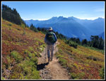
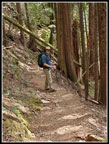
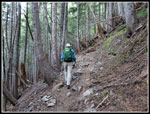 John On The Trail |
 First Fall Colors |
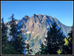 View Of Big Four |
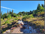
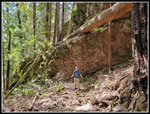
 Across Perry Creek |
 Dickerman Summit Above |
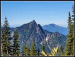 Hall Peak & Mt. Pilchuck |
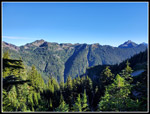
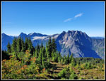 Views South |
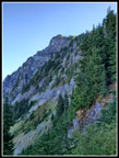
 Last Climb |
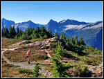 Lone Hiker & Meadow |
 Del Campo Peak |
 More Fall Colors |
 Better Colors |
 Hazy View |
 Looking Into Sun |
 Hazy Chimney Rock |
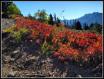 Great Fall Colors |
 Eldorado Peak |
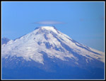 Mt. Baker |
 Stillaguamish Pk & Baker |
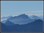
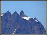
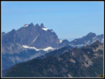 Three Fingers Mountain |
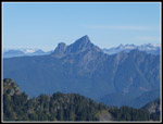
 Sloan Peak |
 Mt. Shuksan |
 Lookout |
 White Chuck Mt. |
 Glacier Peak & Sloan |
 Dome Peak |
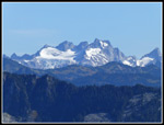
 Glacier Peak Close Up |
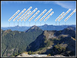 Named Peaks |
 John Atop Dickerman |
 White Chuck & Pugh |
 3 Fingers & Whitehorse |
 Sperry & Vesper Pks |
 Heading Down |
 Last View South |
 Last Fall Colors |
 John Descending |
 John & Big Rocks |
Trips - 2022
Home