06-07-25
Gary
joined me for a hike at Diablo and Ross Lakes. In 2022 we hiked the Diablo
Lake Trail to Ross Dam and a
little way along the Ross Dam Trail and back. This time we decided to
start at Ross Dam, hike the Diablo Lake Trail to the viewpoint of the
lake and peaks to the south, return to Ross Dam, and hike the trail to
Green Point Campground. Bad weather the previous few weeks brought the
trip into June. We met at the Ash Way Park and Ride at 6:25 am. It was
my turn to drive. We had traffic all the way to Darrington but it was
all moving at a good clip. I had nobody ahead of me through Newhalem
and on. We arrived at the Ross Lake parking lot and trailhead at about
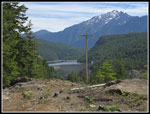
8:25 am. This is a very unusual trip in that the highest point of the
day is the trailhead. It is not a very high high point as it is only at
2125'. The low point of the day would be at 1210'. That meant only 915
between high and low yet we gained almost 3000'. The lot was more than
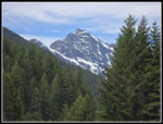
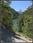
75% full when we arrived. Though the day would rise to the mid 80s, it
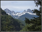
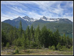
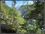
was comfortably cool at the start. The lot has views to snowy peaks
near Colonial Peak.
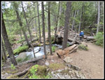
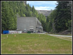
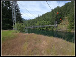
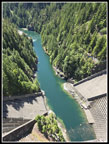
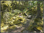
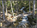
The trail descends immediately, soon crossing Happy Creek on a bridge with a waterfall above. The trail is smooth and we made good time heading downhill. Lower down we had a view of the top of the dam and the lake. The trail ended and we went left on a road quickly reaching a junction. Right is to the dam and we would take that route later. Now, we went left on the road down to the suspension bridge and powerhouse. When we realized that we had not seen a crossing of Happy Creek were were surprised. A look at the map showed we crossed over it just after leaving trail for road. We heard nothing. Later Gary unraveled the mystery. I had been on this trail only one time before. That was on 5-14-88, just over 37 years ago. I was sick that day so instead of hiking I drove up to Ross Lake and hiked down to and across the dam. In 2022 Gary and I hiked across the dam on the trip mentioned above. We hiked down the road and did not take the side road to the dock where the ferry arrives from Diablo. We planned to check it out on our way back. We reached the suspension bridge at 9:28 am. We were 2 miles along on our trip. It was time for a break. It was already getting warmer.
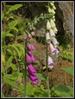
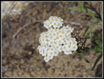
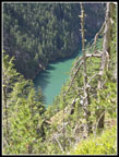
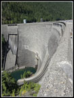
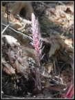
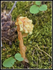
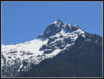
The bridge spot is near the powerhouse with the 540' tall dam right behind it. The dam is only 60' shorter than the Space Needle. We crossed the bridge and headed uphill. We had a steady climb on the Diablo Lake Trail. After climbing up alongside powerlines we started a smooth traverse to the north. Wildflowers seen here included foxglove, spring beauty, starflowers, and lupine. We also saw a saprophyte right at peak. There are some creeks on this climb but only two had any water flowing. We soon saw the first of several groups coming downhill. It seemed early to see people who hiked more than 3.5 miles from Diablo so early in the morning. We must have seen close to ten hikers in short order. The trail leaves deep forest near the powerline corridor. We had some views out to the dam with 9075' Jack Mountain behind it. The trail gets quite narrow with a very steep drop of nearly 800' to the narrow passage of Diablo Lake heading for Ross Dam.
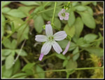
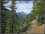
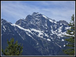
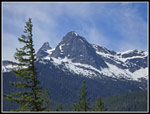
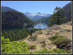
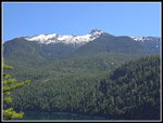
We saw some lupine, Indian paintbrush, Valerian, Columbia Lewisia, and penstemon along here. The trail reaches an elevation of about 2000' then makes a slight descent. We reached the short side trail to the viewpoint which is under the powerlines. Some of Diablo Lake is below. To the south are Colonial and Pyramid Peaks and Paul Bunyan's Stump. They are between 7000' and 7700'. There are a lot of jagged snowy peaks in the North Cascades but many of them are not visible from a car. A bit of hiking provides a lot of visual beauty. It was getting quite warm when we arrived at 10:45 am. There were no other hikes there. It was time for some food and water and views and photos. Powerlines were in the photos unless you drop a little lower on the slope. Our break lasted until 11:07 am. I could have stayed longer but we still had a lot of hiking and driving to do this day. So far we had covered 4 miles.
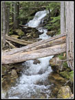
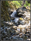
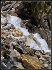
We retraced our route back to the suspension bridge.We passed many of the hikers who we had passed earlier who were now heading back. We stopped at the Ross Dam viewpoint just off the main trail for a look. Near the bottom of the trail the route switches back to the right and a path goes left. I could now hear the roaring of water and suggested we check it out. On my three previous trips on the Diablo Trail I had not done so. A short walk brought us to a steep creek bed with water flowing over cascades down to Diablo Lake. It was shaded with some cool breeze. We took photos and found a spot along the edge of the bed and decided it was time for a lunch break. This spot was much nicer than down on the grass by the bridge. We arrived at 12:12 pm and were in no hurry to leave. In fact, we stayed until 1:01 pm. Near the end a group arrived and then a single hiker though they left just before we did. It was a really neat and unexpected spot for lunch.
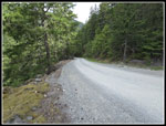
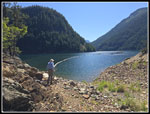
We hiked back to and across the suspension bridge, arriving at 1:11 pm. We had traveled 6.1 miles so far. We were back at the lowest spot on our trip. It was time to hike up to Ross Dam. First we decided to stop at the dock. We met a hiker who was trying to figure out where the boat arrives. There was no sign at the suspension bridge. We took him to the dock. After going through the tunnel, at the junction for the spur to the dock there is a sign. They really need one back at the bridge for one way hikers looking for the boat home. We stopped at the dock for a few minutes, said goodbye to the hiker who had an hour to wait for the boat. We headed back up the road. Earlier, at our stop under the powerlines before dropping down to the bridge. we spotted a vertical rock face across the valley. The road went right above the top. We decided to look for the spot. I expected to find a boot path over to it. We guesstimated the spot and had an easy walk over to it. The drop is vertical. It was a pretty good viewpoint. That done we went back to the road.
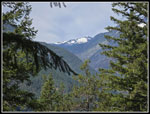
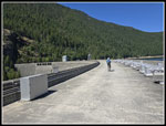
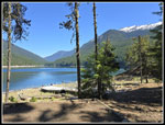
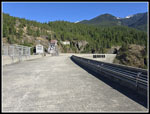
We soon arrived at the road junction. right goes back to the trailhead. Left drops to the dam. They blasted an cut in the solid rock to reach where the top of the dam would be. It was a nice shady spot. It was now 2:10 pm and it was over 80 degrees. The cement dam top provided no shade. It was now really hot. I brought my Chrome Dome umbrella and now put it to use. It reflected away the direct sunshine. I felt much better. Our original plan was to cross the bridge and hike another 1.6 miles to Green Point Campground. We now calculated that would take us up to about 12 miles with nearly 3000' of gain on what was now a very hot day. We crossed the bridge. Views out to peaks from Colonial to Jack were really good. On our 2022 visit the lake was extremely low. Now it was almost up to full level. The walkways to the floating resort along the shore uplake were scary steep in 2022. Now they looked about level. We decided to press on.
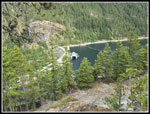
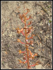
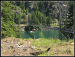
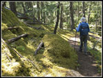
The trail turned out to be more forested than we recalled. The shade was much appreciated. The trail starts out gaining elevation then levels off. There were some wildflowers along the way. The big surprise were several neat varieties of saprophytes. The candysticks were near prime. The pinesaps were also very colorful. The candysticks are a favorite as they have alternating red and white stripes. We continued on and reached the trail down to the resort at .80 miles. A quick .30 miles later we reached the trail down to Green Point. I thought it was only .30 miles. It turns out that it is .50 miles. The trail loses about 350'. That does not sound like much but it is narrow and rocky and out in the sunshine much of the way. Just down the trail is another viewpoint. This is well worth the time. We had more great views of previously seen peaks plus a clear view of Ruby Mountain too. We decided to continue to the campground. The narrow rocky trail was my least favorite of the day. It just seemed to go on and on and on. When we reached the bottom in a mossy forest, the route climbed up and over a small hill. At last we were at lakeside.
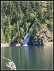
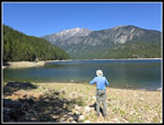
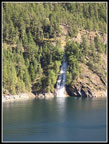
There was one tent with a family there. Several stand up paddleboarders were near shore. We sat at a picnic table in the shade and rested. Later we checked Gary's thermometer and it read 86 degrees. The first hot days of the year on the trail are the hardest. It was 3:35 pm and near the heat of the day. We walked to the rocky shore for more photos. Jack Mountain rose steeply beside the roughly 1600' lake. By 3:49 pm it was time to go. The climb back up to the junction was not as bad as I feared. From there the trail was mostly flat or downhill with a few short climbs. Back near the dam we had a clear view across the lake to Happy Falls. We again thought about not hearing it where it must have gone under the road. From our angle we could see the big plume of water falling into the lake but nothing above it. Later at home, Gary checked out maps and found that Happy Creek flows down a creek bed then makes a sharp turn right and heads for behind the dam where it empties. In fact, the old creek flowed down to what is now below the dam. They diverted it in a tunnel to behind the dam where it pops out of the rock and into the lake. Mystery solved.
The walk across the dam and up about 500' to the trailhead was hot but not too bad. Near the end of our day a familiar voice said "hi". It was the guy we led to the boat back to Diablo. He waited an hour for the boat, took the 30 minute cruise back to his car, drove to Washington Pass, and stopped at the Ross Dom trail where he met us. That was a very unexpected turn of events. We arrived back at the car at 5:25 pm. It was 12.5 hours after I woke up that morning. The drive home was pretty easy. We were late enough to miss the usual slowdowns near Marysville. We had about a mile of slower than up to the limit again. A stop for a milkshake was well worth it.
This was a route we had never done together. We had each hiked most of the trails but not all. Neither of us had been to Green Point. We had some wildflowers, some very good saprophytes, lots of great mountain views, and lunch in a creek bed but a cascading creek that was cool and comfortable. I had a little over 240 miles to drive but an early start and late return minimized traffic. This was a fun trip of short climbs and different trails that added up to 12 miles and 2945' of gain. It was not a bad way to spend a day on the trail.
Click on thumbnails to get
larger pictures.
Trips - 2025
Home
The trail descends immediately, soon crossing Happy Creek on a bridge with a waterfall above. The trail is smooth and we made good time heading downhill. Lower down we had a view of the top of the dam and the lake. The trail ended and we went left on a road quickly reaching a junction. Right is to the dam and we would take that route later. Now, we went left on the road down to the suspension bridge and powerhouse. When we realized that we had not seen a crossing of Happy Creek were were surprised. A look at the map showed we crossed over it just after leaving trail for road. We heard nothing. Later Gary unraveled the mystery. I had been on this trail only one time before. That was on 5-14-88, just over 37 years ago. I was sick that day so instead of hiking I drove up to Ross Lake and hiked down to and across the dam. In 2022 Gary and I hiked across the dam on the trip mentioned above. We hiked down the road and did not take the side road to the dock where the ferry arrives from Diablo. We planned to check it out on our way back. We reached the suspension bridge at 9:28 am. We were 2 miles along on our trip. It was time for a break. It was already getting warmer.
The bridge spot is near the powerhouse with the 540' tall dam right behind it. The dam is only 60' shorter than the Space Needle. We crossed the bridge and headed uphill. We had a steady climb on the Diablo Lake Trail. After climbing up alongside powerlines we started a smooth traverse to the north. Wildflowers seen here included foxglove, spring beauty, starflowers, and lupine. We also saw a saprophyte right at peak. There are some creeks on this climb but only two had any water flowing. We soon saw the first of several groups coming downhill. It seemed early to see people who hiked more than 3.5 miles from Diablo so early in the morning. We must have seen close to ten hikers in short order. The trail leaves deep forest near the powerline corridor. We had some views out to the dam with 9075' Jack Mountain behind it. The trail gets quite narrow with a very steep drop of nearly 800' to the narrow passage of Diablo Lake heading for Ross Dam.
We saw some lupine, Indian paintbrush, Valerian, Columbia Lewisia, and penstemon along here. The trail reaches an elevation of about 2000' then makes a slight descent. We reached the short side trail to the viewpoint which is under the powerlines. Some of Diablo Lake is below. To the south are Colonial and Pyramid Peaks and Paul Bunyan's Stump. They are between 7000' and 7700'. There are a lot of jagged snowy peaks in the North Cascades but many of them are not visible from a car. A bit of hiking provides a lot of visual beauty. It was getting quite warm when we arrived at 10:45 am. There were no other hikes there. It was time for some food and water and views and photos. Powerlines were in the photos unless you drop a little lower on the slope. Our break lasted until 11:07 am. I could have stayed longer but we still had a lot of hiking and driving to do this day. So far we had covered 4 miles.
We retraced our route back to the suspension bridge.We passed many of the hikers who we had passed earlier who were now heading back. We stopped at the Ross Dam viewpoint just off the main trail for a look. Near the bottom of the trail the route switches back to the right and a path goes left. I could now hear the roaring of water and suggested we check it out. On my three previous trips on the Diablo Trail I had not done so. A short walk brought us to a steep creek bed with water flowing over cascades down to Diablo Lake. It was shaded with some cool breeze. We took photos and found a spot along the edge of the bed and decided it was time for a lunch break. This spot was much nicer than down on the grass by the bridge. We arrived at 12:12 pm and were in no hurry to leave. In fact, we stayed until 1:01 pm. Near the end a group arrived and then a single hiker though they left just before we did. It was a really neat and unexpected spot for lunch.
We hiked back to and across the suspension bridge, arriving at 1:11 pm. We had traveled 6.1 miles so far. We were back at the lowest spot on our trip. It was time to hike up to Ross Dam. First we decided to stop at the dock. We met a hiker who was trying to figure out where the boat arrives. There was no sign at the suspension bridge. We took him to the dock. After going through the tunnel, at the junction for the spur to the dock there is a sign. They really need one back at the bridge for one way hikers looking for the boat home. We stopped at the dock for a few minutes, said goodbye to the hiker who had an hour to wait for the boat. We headed back up the road. Earlier, at our stop under the powerlines before dropping down to the bridge. we spotted a vertical rock face across the valley. The road went right above the top. We decided to look for the spot. I expected to find a boot path over to it. We guesstimated the spot and had an easy walk over to it. The drop is vertical. It was a pretty good viewpoint. That done we went back to the road.
We soon arrived at the road junction. right goes back to the trailhead. Left drops to the dam. They blasted an cut in the solid rock to reach where the top of the dam would be. It was a nice shady spot. It was now 2:10 pm and it was over 80 degrees. The cement dam top provided no shade. It was now really hot. I brought my Chrome Dome umbrella and now put it to use. It reflected away the direct sunshine. I felt much better. Our original plan was to cross the bridge and hike another 1.6 miles to Green Point Campground. We now calculated that would take us up to about 12 miles with nearly 3000' of gain on what was now a very hot day. We crossed the bridge. Views out to peaks from Colonial to Jack were really good. On our 2022 visit the lake was extremely low. Now it was almost up to full level. The walkways to the floating resort along the shore uplake were scary steep in 2022. Now they looked about level. We decided to press on.
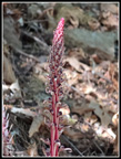
The trail turned out to be more forested than we recalled. The shade was much appreciated. The trail starts out gaining elevation then levels off. There were some wildflowers along the way. The big surprise were several neat varieties of saprophytes. The candysticks were near prime. The pinesaps were also very colorful. The candysticks are a favorite as they have alternating red and white stripes. We continued on and reached the trail down to the resort at .80 miles. A quick .30 miles later we reached the trail down to Green Point. I thought it was only .30 miles. It turns out that it is .50 miles. The trail loses about 350'. That does not sound like much but it is narrow and rocky and out in the sunshine much of the way. Just down the trail is another viewpoint. This is well worth the time. We had more great views of previously seen peaks plus a clear view of Ruby Mountain too. We decided to continue to the campground. The narrow rocky trail was my least favorite of the day. It just seemed to go on and on and on. When we reached the bottom in a mossy forest, the route climbed up and over a small hill. At last we were at lakeside.
There was one tent with a family there. Several stand up paddleboarders were near shore. We sat at a picnic table in the shade and rested. Later we checked Gary's thermometer and it read 86 degrees. The first hot days of the year on the trail are the hardest. It was 3:35 pm and near the heat of the day. We walked to the rocky shore for more photos. Jack Mountain rose steeply beside the roughly 1600' lake. By 3:49 pm it was time to go. The climb back up to the junction was not as bad as I feared. From there the trail was mostly flat or downhill with a few short climbs. Back near the dam we had a clear view across the lake to Happy Falls. We again thought about not hearing it where it must have gone under the road. From our angle we could see the big plume of water falling into the lake but nothing above it. Later at home, Gary checked out maps and found that Happy Creek flows down a creek bed then makes a sharp turn right and heads for behind the dam where it empties. In fact, the old creek flowed down to what is now below the dam. They diverted it in a tunnel to behind the dam where it pops out of the rock and into the lake. Mystery solved.
The walk across the dam and up about 500' to the trailhead was hot but not too bad. Near the end of our day a familiar voice said "hi". It was the guy we led to the boat back to Diablo. He waited an hour for the boat, took the 30 minute cruise back to his car, drove to Washington Pass, and stopped at the Ross Dom trail where he met us. That was a very unexpected turn of events. We arrived back at the car at 5:25 pm. It was 12.5 hours after I woke up that morning. The drive home was pretty easy. We were late enough to miss the usual slowdowns near Marysville. We had about a mile of slower than up to the limit again. A stop for a milkshake was well worth it.
This was a route we had never done together. We had each hiked most of the trails but not all. Neither of us had been to Green Point. We had some wildflowers, some very good saprophytes, lots of great mountain views, and lunch in a creek bed but a cascading creek that was cool and comfortable. I had a little over 240 miles to drive but an early start and late return minimized traffic. This was a fun trip of short climbs and different trails that added up to 12 miles and 2945' of gain. It was not a bad way to spend a day on the trail.
 View From Parking Lot |
 Happy Creek Bridge |
 Happy Creek |
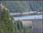
 Ross Dam & Lake |
 Colonial Area Peaks |
 Road Down |
 Powerhouse & Dam |
 Suspension Bridge |
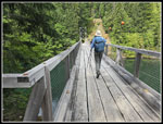 Gary Crosses Bridge |
 Foxglove |
 Spring Beauty |
 Starflower |
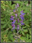 Lupine |
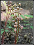
 Coralroot |
 Daisylike Flower |
 View From Trail |
 Ross Lake Resort |
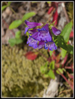 Penstemon |
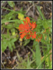 Indian Paintbrush |
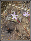 Another Spring Beauty |
 Valerian |
 Gary On Trail |
 Green Diablo Lake |
 Davis Peak |
 Peaks From Viewpoint |
 Colonial Peak |
 BP Stump & Pyramid Pk |
 First Stonecrop |
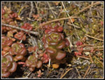 Stonecrop II |
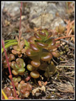 Stonecrop III |
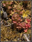 Last Stonecrop |
 |
 Viewpoint Of Dam |
 Riprap Creek |
 Lunch Spot |
 Back At Bridge |
 Heading For The Dam |
 Sourdoughish |
 Ross Dam |
 Top Of Ross Dam |
 Looking Down Dam |
 Happy Creek Falls |
 Candystick |
 Perfect Candystick |
 Pinesap |
 Gary At Work |
 Ruby Mountain |
 Ruby Close Up |
 Very Green Point |
 Campground |
 Green Point Beach |
 Looking South |
 Heading Back |
 Happy Creek Falls II |
 On The Dam |
 Almost Back |
Trips - 2025
Home