02-15-26
Gary
joined me for another trip to
Chuckanut Mountain. This was the Presidents Day weekend. Sunday was
looking to be sunny up north. Monday looked to be wet. I went for a
close in hike to Grand Ridge on Saturday getting in 8 miles with 1000'
of gain. On Sunday we met at Ash Way and I drove north. We had some fog
on the way but it cleared up as we headed onto Chuckanut Drive. We have
hiked from the Oyster Dome trailhead and the Two Dollar trailhead but
not from the Lost Lake trailhead. Four weeks earlier in January we did
a loop from the Two Dollar start to Fragrance Lake, Burnout Knob, and
the Rock Trail. This time we would include part of that route but with
a lower start and adding a route to Lost Lake. The start up to Burnout
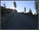
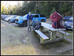
Knob would be a new trail for us. We arrived at the trailhead just
after 8:00 am. It was 27F at the start of Chuckanut Drive but up to 34F
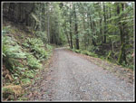
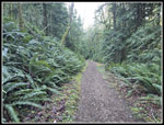
at the trailhead. The route starts on an old logging road. We made good
time as that helped us warm up. There is the bottom of a bike only
trail early on and a trail that goes over to the Fragrance Lake Trail.
After that we waited for a road/trail going right and up to Burnout
Knob. When we reached it Gary checked his GPS and it had only recorded
.45 miles that worked out to 1.1 mph and we knew we were going faster
than that. It turns out that it started recording then stopped until he
checked it. It then just drew a straight line to our current position.
The actual distance was 1.02 miles. We determined that on our way down.
The GPS worked perfectly after the starting hiccup. The route to
Burnout Knob goes out of Larrabee State Park so does not show on the
park maps found at multiple junctions. The GPS map did show the route.
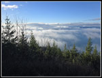
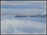
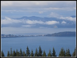
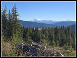
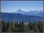
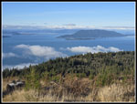
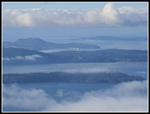
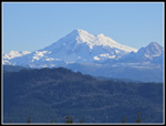
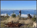
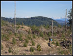
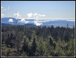
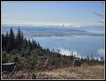
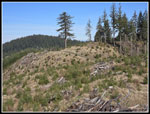
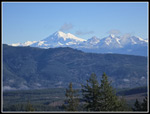
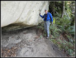
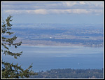
On our hike up we were passed by several groups of runners. I expected most people would be going up the main road/trail to Fragrance Lake and not on our route to Burnout Knob. At one point there is a small viewpoint not blocked by the forest. A tent and a bike were there. We stopped for the view. The road finally switches back and climbs steeply up to the Knob. We left forest and went into the clearcut that provides the views up above. The sunshine made it a lot warmer. A couple younger hikers zoomed by us here. The road went over the ridge and back to Burnout Knob. We arrived to find it unoccupied. It was now 9:49 am. It took us 1:42 to reach the top. From the Two Dollar Trail in January it took us 2:37. The earlier arrival meant different lighting. There was patchy fog below us. It was mostly blue sky overhead. The Olympic Mountains were lost in clouds. We never saw Mt. Rainier to the south. We did have a very clear view of Mt. Baker and good views to the San Juan Islands. The views were not perfectly clear but still pretty good. I looked over to Oyster Dome and with my zoom lens I did not see any colorful clothing at Oyster Dome. Last time I did. We had an early brunch and soaked up the views. We did see more people hiking by on the road/trail. Even early in the day it was more crowded than we usually see here.
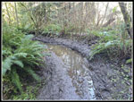
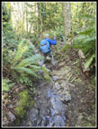
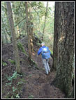
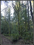
Two groups arrived just before we left. At 10:26 am we headed on. Four hikers from a group we saw at the Knob and four others were hiking on the road. We headed north then turned off on a short spur to another great view of Mt. Baker. It is among the best Baker views I have had. One group was heading for us but then turned around and head back to the viewpoint. Another group arrived just after us. Two hikers were there when we arrived. The turnaround hikers headed down the bike trail to Lost Lake. We had hiked this trail twice previously. After enjoying the sunshine and views we headed down the bike trail. This is just a rocky trail with a bike built rut in the summer. In the winter it is a rocky trail with a bike built rut and running water plus mud. I wore waterproof boots and I'm glad I did. Most surprising to me is that neither of us slipped and fell in the water and/or mud. Though this is a not well publicized trail, we have seen other hikers all three times we have hiked it. My knee has been sore for months but has been getting better. It only hurts on steep descents. This trail was a good challenge and my knee did very well.
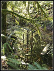
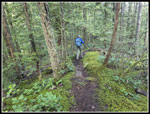
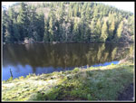
The route reaches a bottom and goes along with swamp puddles on both sides and water running in the trail. Finally it climbs a bit and dries out. The route follows a narrow ridge. It drops steeply on both sides. Lost Lake is in the depression to the left. The trail has some ups and downs as the lake comes into sight between the trees. The trail drops to a crossing at an outlet on the side of the lake. We passed another group there. There is one good spot for a break just beyond the outlet. It is open with views of the lake below. It is usually full of people. This day we found it unoccupied. We stopped here for our lunch break at 11:43 am. Sunshine was around us but the trees blocked the low winter sun where we sat. It was cool. enough that I put on a wind shirt. We had hiked 5.8 miles so far. A couple other groups hiked by as we rested. We packed up and continued on at about 12:00 pm. Crossing the end of the lake is usually muddy in fall through spring. It was this day. A few small logs were floating in the trail but we made it across with dry feet. A couple minutes later we reached the Lost Lake Road. A right turn goes on North Lost Lake Road to the north end of the park. Left is on South Lost Lake Road heading for the Rock Trail and eventually back to our trailhead. We chose to take a route with more elevation gain going up the Rock Trail to the Cyrus Gates Overlook.
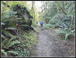
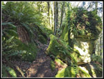
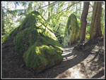
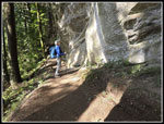
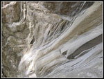
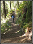
Once at the next junction, we headed right and uphill on the Rock Trail. We were too early for any wildflowers. The deciduous trees were still leafless. In places higher up we cold see through the trees to Mt. Baker. I always find enough interesting things to end up with a lot of photos on this trail. This day was not an exception. There are several steep staircases going up with the biggest ones at the upper end. Thee was some water dripping down the near vertical sandstone walls higher up. I tried a few slow motion videos. Without the leaves, we had a little sunshine in places. The big boulders covered with bright green moss and ferns never gets old. There is a short bridge over a small creek that has skunk cabbage blooming in the spring. With our warm start of the year, I have been on the lookout for at least a skunk cabbage leaf to be out very early. Much to my surprise I saw some. This is the earliest I have ever seen skunk cabbage leaves. A few thermometer checks still had us in the upper 30s though it felt warmer when there was a little sunshine.
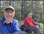
Near the top we stopped to think about the final stairways. A month earlier, I took a video of climbing all the stairs. Gary took a fast motion one but we walked to fast and it only took about 15 seconds of video. This time we both took a fast motion video but walked very slowly. My result was a 4 minute video of Gary climbing up that was compressed to 33 seconds. It actually turned out pretty good. At the top we just had a short walk to the Overlook. It was 1:27 pm when we arrived. The parking lot was almost full. Again, the low sun had us in shade but just barely. Over at the outhouse on the way out we were in sunshine. Just as we left forest at the Overlook, I noticed hair ice. Hair ice forms on certain deciduous dead branches below freezing. Once the temperature gets over 32F it starts to melt immediately. This afternoon it was still frozen. That was a surprise. Gary and I have had several good hair ice sightings this winter.
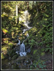
We had a last food and water break. In the distance we could see the towers of Vancouver and its suburbs. My cellphone does not have the zoom capabilities of previous cameras but the buildings were visible. We headed down the road at 1:41 pm. This side of Chuckanut Mountain is forested and does not get sunshine in winter. It was noticeably colder. From the Overlook at about 1850' to the parking lot where we started at 190' we had 1660' net to lose. We still had 3.6 miles to go. Descending Cleator Road was the worst part. The road is hard but not rocky and there were cars and bikes passing us. It was better when we turned off onto an old road that is now a trail. This ended motor vehicles going by. The forest has a lot of cedar trees. At the next junction a trail goes right a short way to Fragrance Lake. We saw it coming and going in January and had no desire for a side trip. The next junction left goes out to Burnout Knob, the bottom of the Rock Trail and Lost Lake. Straight ahead goes back to our trailhead and my car. We took a wrong turn here in 2024 and descended the road past a washout to a waterfall before realizing our error and heading back up. We passed the washout and where a very steep trail from Cyrus Gates Overlook to the parking lot trailhead crosses the road/trail we saw some mountain bikers. They shot down very quickly on the bike trail. Hikers are not allowed on this trail.
The waterfall took a lot longer to reach than we expected. It is a really nice falls. It's not tall but very scenic. It is better than the one on The Two Dollar Trail near Fragrance Lake. Not long after the falls we closed our loop where we headed off to Burnout Knob in the morning. The GPS error in the morning listed it as .45 miles from the trailhead to the junction. Going down, it correctly recorded 1.02 miles. This allowed us to correct the actual distance to 11.4 miles with 2700' of elevation gain. The lot was still mostly full with about half a dozen open spots. We arrived at the car at 3:06 pm. We made good time coming down the last 3.6 miles in 1:25 with several stops.
We have done several trips up to Chuckanut Mountain each of the past 8-10 years. It is always fun to start at a new trailhead and hike partly on new trails. The muddy trail down from Burnout Knob to Lost Lake was my least favorite part but the rest of the trails were in fine shape. I was really surprised to see so many people near Burnout Knob so early in the day. We saw people off and on but it was not crowded after the viewpoints near Burnout Knob. Even the drive home was pretty easy on a Sunday afternoon. All in all, it was a very nice day to do a dry snow free winter hike.
Click on thumbnails to get
larger pictures.
Trips - 2026
Home
On our hike up we were passed by several groups of runners. I expected most people would be going up the main road/trail to Fragrance Lake and not on our route to Burnout Knob. At one point there is a small viewpoint not blocked by the forest. A tent and a bike were there. We stopped for the view. The road finally switches back and climbs steeply up to the Knob. We left forest and went into the clearcut that provides the views up above. The sunshine made it a lot warmer. A couple younger hikers zoomed by us here. The road went over the ridge and back to Burnout Knob. We arrived to find it unoccupied. It was now 9:49 am. It took us 1:42 to reach the top. From the Two Dollar Trail in January it took us 2:37. The earlier arrival meant different lighting. There was patchy fog below us. It was mostly blue sky overhead. The Olympic Mountains were lost in clouds. We never saw Mt. Rainier to the south. We did have a very clear view of Mt. Baker and good views to the San Juan Islands. The views were not perfectly clear but still pretty good. I looked over to Oyster Dome and with my zoom lens I did not see any colorful clothing at Oyster Dome. Last time I did. We had an early brunch and soaked up the views. We did see more people hiking by on the road/trail. Even early in the day it was more crowded than we usually see here.
Two groups arrived just before we left. At 10:26 am we headed on. Four hikers from a group we saw at the Knob and four others were hiking on the road. We headed north then turned off on a short spur to another great view of Mt. Baker. It is among the best Baker views I have had. One group was heading for us but then turned around and head back to the viewpoint. Another group arrived just after us. Two hikers were there when we arrived. The turnaround hikers headed down the bike trail to Lost Lake. We had hiked this trail twice previously. After enjoying the sunshine and views we headed down the bike trail. This is just a rocky trail with a bike built rut in the summer. In the winter it is a rocky trail with a bike built rut and running water plus mud. I wore waterproof boots and I'm glad I did. Most surprising to me is that neither of us slipped and fell in the water and/or mud. Though this is a not well publicized trail, we have seen other hikers all three times we have hiked it. My knee has been sore for months but has been getting better. It only hurts on steep descents. This trail was a good challenge and my knee did very well.
The route reaches a bottom and goes along with swamp puddles on both sides and water running in the trail. Finally it climbs a bit and dries out. The route follows a narrow ridge. It drops steeply on both sides. Lost Lake is in the depression to the left. The trail has some ups and downs as the lake comes into sight between the trees. The trail drops to a crossing at an outlet on the side of the lake. We passed another group there. There is one good spot for a break just beyond the outlet. It is open with views of the lake below. It is usually full of people. This day we found it unoccupied. We stopped here for our lunch break at 11:43 am. Sunshine was around us but the trees blocked the low winter sun where we sat. It was cool. enough that I put on a wind shirt. We had hiked 5.8 miles so far. A couple other groups hiked by as we rested. We packed up and continued on at about 12:00 pm. Crossing the end of the lake is usually muddy in fall through spring. It was this day. A few small logs were floating in the trail but we made it across with dry feet. A couple minutes later we reached the Lost Lake Road. A right turn goes on North Lost Lake Road to the north end of the park. Left is on South Lost Lake Road heading for the Rock Trail and eventually back to our trailhead. We chose to take a route with more elevation gain going up the Rock Trail to the Cyrus Gates Overlook.
Once at the next junction, we headed right and uphill on the Rock Trail. We were too early for any wildflowers. The deciduous trees were still leafless. In places higher up we cold see through the trees to Mt. Baker. I always find enough interesting things to end up with a lot of photos on this trail. This day was not an exception. There are several steep staircases going up with the biggest ones at the upper end. Thee was some water dripping down the near vertical sandstone walls higher up. I tried a few slow motion videos. Without the leaves, we had a little sunshine in places. The big boulders covered with bright green moss and ferns never gets old. There is a short bridge over a small creek that has skunk cabbage blooming in the spring. With our warm start of the year, I have been on the lookout for at least a skunk cabbage leaf to be out very early. Much to my surprise I saw some. This is the earliest I have ever seen skunk cabbage leaves. A few thermometer checks still had us in the upper 30s though it felt warmer when there was a little sunshine.
Near the top we stopped to think about the final stairways. A month earlier, I took a video of climbing all the stairs. Gary took a fast motion one but we walked to fast and it only took about 15 seconds of video. This time we both took a fast motion video but walked very slowly. My result was a 4 minute video of Gary climbing up that was compressed to 33 seconds. It actually turned out pretty good. At the top we just had a short walk to the Overlook. It was 1:27 pm when we arrived. The parking lot was almost full. Again, the low sun had us in shade but just barely. Over at the outhouse on the way out we were in sunshine. Just as we left forest at the Overlook, I noticed hair ice. Hair ice forms on certain deciduous dead branches below freezing. Once the temperature gets over 32F it starts to melt immediately. This afternoon it was still frozen. That was a surprise. Gary and I have had several good hair ice sightings this winter.
We had a last food and water break. In the distance we could see the towers of Vancouver and its suburbs. My cellphone does not have the zoom capabilities of previous cameras but the buildings were visible. We headed down the road at 1:41 pm. This side of Chuckanut Mountain is forested and does not get sunshine in winter. It was noticeably colder. From the Overlook at about 1850' to the parking lot where we started at 190' we had 1660' net to lose. We still had 3.6 miles to go. Descending Cleator Road was the worst part. The road is hard but not rocky and there were cars and bikes passing us. It was better when we turned off onto an old road that is now a trail. This ended motor vehicles going by. The forest has a lot of cedar trees. At the next junction a trail goes right a short way to Fragrance Lake. We saw it coming and going in January and had no desire for a side trip. The next junction left goes out to Burnout Knob, the bottom of the Rock Trail and Lost Lake. Straight ahead goes back to our trailhead and my car. We took a wrong turn here in 2024 and descended the road past a washout to a waterfall before realizing our error and heading back up. We passed the washout and where a very steep trail from Cyrus Gates Overlook to the parking lot trailhead crosses the road/trail we saw some mountain bikers. They shot down very quickly on the bike trail. Hikers are not allowed on this trail.
The waterfall took a lot longer to reach than we expected. It is a really nice falls. It's not tall but very scenic. It is better than the one on The Two Dollar Trail near Fragrance Lake. Not long after the falls we closed our loop where we headed off to Burnout Knob in the morning. The GPS error in the morning listed it as .45 miles from the trailhead to the junction. Going down, it correctly recorded 1.02 miles. This allowed us to correct the actual distance to 11.4 miles with 2700' of elevation gain. The lot was still mostly full with about half a dozen open spots. We arrived at the car at 3:06 pm. We made good time coming down the last 3.6 miles in 1:25 with several stops.
We have done several trips up to Chuckanut Mountain each of the past 8-10 years. It is always fun to start at a new trailhead and hike partly on new trails. The muddy trail down from Burnout Knob to Lost Lake was my least favorite part but the rest of the trails were in fine shape. I was really surprised to see so many people near Burnout Knob so early in the day. We saw people off and on but it was not crowded after the viewpoints near Burnout Knob. Even the drive home was pretty easy on a Sunday afternoon. All in all, it was a very nice day to do a dry snow free winter hike.
 Heading Up The Road |
 Lots Of Fog |
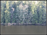
 View Southwest |
 Runners Ahead |
 Samish Island |
 First Mt. Baker View |
 Baker & Twin Sisters |
 Oyster Dome |
 Lummi Island |
 Anacortes Ferry |
 Mt. Baker Close Up |
 Gary At Burnout Knob |
 Hikers Leaving |
 Lit Up Clouds |
 View South |
 Big Group |
 Baker Again |
 Muddy Trail |
 Reflection |
 Wet & Rocky |
 Ridge To Lost Lake |
 Mossy Trail |
 Lost Lake |
 Lunch Time |
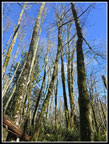
 Lit Up Trees |
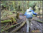 More Mud |
 South Lost Lake Trail |
 Blue Sky |
 Mossy Rocks |
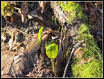 Skunk Cabbage! |
 Moss & Shadows |
 Stick Is In Place |
 Looking Back |
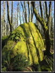
 Big White Rock |
 Rock Layers |
 On The Rock Trail |
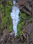 Hair Ice |
 Vancouver, BC |
 Cyrus Gates Overlook |
 Heading Down |
 Mossy Trees |
 Waterfall |
Trips - 2026
Home