2-21-26
Gary
joined me for a close in hike. The forecast had wind gust up to 40 mph
from the southeast. That usually means the north side of Tiger Mt. or
Cougar Mt. They are mostly protected from wind. Light rain also was
expected. We did not do a mid-week hike so we were in regardless. Of
course, in the morning the forecast improved. The rain would hold off a
few hours longer. The forecast still called for high gusts in the
morning but weather stations around Cougar were at 0-4 mph. We met at
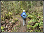
my house and Gary drove east. We arrived at the Red Town Trailhead at
7:25 am and were on the trail at 7:32 am. It was not raining at the
start. The park opens at 8:00 am but their were about ten cars already
in the lot. I still have not seen the gate closed. We chose to do a
loop clockwise as we would get most of the elevation gain done early.
Hiking downhill with an umbrella is not hard. The wind was zero. There
are a lot of trails and we would aim for a long loop and cut it shorter
if the rain picked up. The first mile is all uphill to the Sky Country
Trailhead. We continued to the Cave Hole Road and up to Fred's
Railroad. We knew that there was a little fresh snow atop Tiger summits
but we did not expect any as Cougar tops out at 1595'.
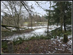
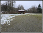
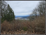
We took the route via Cougar Pass and on up Anti-Aircraft Peak. The only snow we saw all day was atop AA Peak. There was very little left. We crossed the meadow to the far picnic shelter and came back to the other one. Our food and water break was very short. So far we avoided the rain. Our next destination was the Clay Pit. The trail drops down to Tibbetts Creek and then climbs to the Clay Pit. The creek still has some water running. It is dry much of the year. We saw nobody the first couple miles then runners off and on the rest of the way. One group was very large. We could see the Cascade Mountain front peaks on the morning drive. From the Clay Pit there is an open view of Tiger Mountain peaks and Mt. Si. We saw nothing this day. It was cloudy but still dry after 4.7 miles of hiking. We rounded Jerry's Duck Pond on the East Fork Trail and took the old short cut route to Wilderness Peak. That cuts off over a mile. It was Gary's first time on this route.
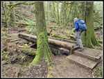
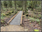
We reached Wilderness Peak, the highest point on Cougar, at 9:57 am. There was one hiker their and a few more arrived while we had a last food and water break. We hiked the main trail down to Shy Bear Pass. A right turn provides two different routes back to the Red Town Trailhead. Going left towards Long View Peak is the longest loop trail. Since the rain was still holding off, we headed that way. In .40 miles we reached Long View Peak. We took the short spur to the Long Gone Views of Long View Peak. The trail continues along and down off Deceiver Ridge. The grade is moderate as it slowly drops down to the creek below. Last year I crossed the creek on the old bridge but the parts for a new bridge were sitting right there. I wanted to get a look at the new bridge. It has steel beams with wood on top. It is much longer than the old bridge and higher above the water. Just below the bridge is Doughty Falls. It was beginning to rain a bit and we chose to pass by the falls. I don't expect there was much water in the falls.
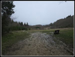
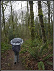
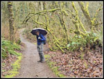
We had another ascent on more gentle switchbacks to another ridge top and then a short drop to the Shy Bear Trail. The rain was on and off and with umbrellas out we stayed dry. Our next objective was Far Country Lookout. We took the trail that goes to the bench and view. There was no view to be seen. Even nearby Marshall's Hill was in the clouds. The trail drops to the Indian Trail. We were right at 9 miles. The Indian Trail is smooth and pretty flat. We passed the Quarry Trail and reached the "T" junction near the Meadow. Both go back to the trailhead. The left trail is less road-like and more interesting. We headed left. Near the For Slope the trail crosses a wet area on a couple short bridges. The big storm late last year put it underwater. When I hiked this section early this year the trail was closed but it was easy to cross the wet spot with dry boots. It was about the same this time. We were short of the 11 mile target so we went right towards the Ford Slope, the main tunnel during long ago coal mining. I recalled a trail to the old dam and looked for it. There was no signed trail but there is an old trail. It provided a view down to what was narrow Coal Creek but now is a series of beaver dammed lakes. We did not find the dam.
We headed back to the trailhead arriving still below 11 miles. We took one last climb up the road/trail to the first junction. That added over 100' of gain. We arrived back at the car at 12:36 pm after 11.2 miles and 1800' of gain. This turned out to be a better trip than we expected. Instead of steady light rain we had a dry first 60% of the hike and light on and off rain the rest of the way. We saw runners all over after the first couple miles but not many hikers. We did have some 5-8 mph winds on ridge tops but almost no wind for most of the hike. Add in a short easy hike both ways and we were home early after a good long 11 miles hike.
Click on thumbnails to get
larger pictures.
Trips - 2026
Home
We took the route via Cougar Pass and on up Anti-Aircraft Peak. The only snow we saw all day was atop AA Peak. There was very little left. We crossed the meadow to the far picnic shelter and came back to the other one. Our food and water break was very short. So far we avoided the rain. Our next destination was the Clay Pit. The trail drops down to Tibbetts Creek and then climbs to the Clay Pit. The creek still has some water running. It is dry much of the year. We saw nobody the first couple miles then runners off and on the rest of the way. One group was very large. We could see the Cascade Mountain front peaks on the morning drive. From the Clay Pit there is an open view of Tiger Mountain peaks and Mt. Si. We saw nothing this day. It was cloudy but still dry after 4.7 miles of hiking. We rounded Jerry's Duck Pond on the East Fork Trail and took the old short cut route to Wilderness Peak. That cuts off over a mile. It was Gary's first time on this route.
We reached Wilderness Peak, the highest point on Cougar, at 9:57 am. There was one hiker their and a few more arrived while we had a last food and water break. We hiked the main trail down to Shy Bear Pass. A right turn provides two different routes back to the Red Town Trailhead. Going left towards Long View Peak is the longest loop trail. Since the rain was still holding off, we headed that way. In .40 miles we reached Long View Peak. We took the short spur to the Long Gone Views of Long View Peak. The trail continues along and down off Deceiver Ridge. The grade is moderate as it slowly drops down to the creek below. Last year I crossed the creek on the old bridge but the parts for a new bridge were sitting right there. I wanted to get a look at the new bridge. It has steel beams with wood on top. It is much longer than the old bridge and higher above the water. Just below the bridge is Doughty Falls. It was beginning to rain a bit and we chose to pass by the falls. I don't expect there was much water in the falls.
We had another ascent on more gentle switchbacks to another ridge top and then a short drop to the Shy Bear Trail. The rain was on and off and with umbrellas out we stayed dry. Our next objective was Far Country Lookout. We took the trail that goes to the bench and view. There was no view to be seen. Even nearby Marshall's Hill was in the clouds. The trail drops to the Indian Trail. We were right at 9 miles. The Indian Trail is smooth and pretty flat. We passed the Quarry Trail and reached the "T" junction near the Meadow. Both go back to the trailhead. The left trail is less road-like and more interesting. We headed left. Near the For Slope the trail crosses a wet area on a couple short bridges. The big storm late last year put it underwater. When I hiked this section early this year the trail was closed but it was easy to cross the wet spot with dry boots. It was about the same this time. We were short of the 11 mile target so we went right towards the Ford Slope, the main tunnel during long ago coal mining. I recalled a trail to the old dam and looked for it. There was no signed trail but there is an old trail. It provided a view down to what was narrow Coal Creek but now is a series of beaver dammed lakes. We did not find the dam.
We headed back to the trailhead arriving still below 11 miles. We took one last climb up the road/trail to the first junction. That added over 100' of gain. We arrived back at the car at 12:36 pm after 11.2 miles and 1800' of gain. This turned out to be a better trip than we expected. Instead of steady light rain we had a dry first 60% of the hike and light on and off rain the rest of the way. We saw runners all over after the first couple miles but not many hikers. We did have some 5-8 mph winds on ridge tops but almost no wind for most of the hike. Add in a short easy hike both ways and we were home early after a good long 11 miles hike.
 Snow Atop AA Peak |
 AA Picnic Shelter |
 Million Dollar View |
 The Clay Pit |
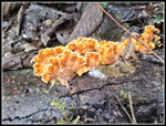 Turkeytail Fungus |
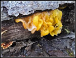 More Fungus |
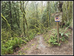
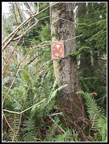 No Horses |
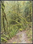
 Mossy Trail Frame |
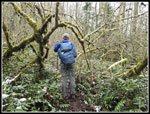
 Gary On Old Trail |
 New Bridge |
 New Bridge Again |
 Umbrella Time |
 Far Country Falls Trail |
 Nice Mossy Color |
 Gary On Trail |
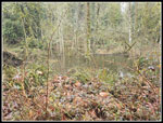 Coal Creek Lakes |
Trips - 2026
Home