01-19-26
Gary
joined me for a MLKing holiday
hike. We chose to head north to Chuckanut Mountain.This was a repeat of
a hike we did in November 2024. On that trip we took a wrong turn and
added a mile and several hundred feet of extra elevation gain. We met
at Ash Way Park & Ride and headed north. It was my turn to
drive. It was right at freezing and cooled as we went north. On
Chuckanut Drive on the flats it was down to 28F. When we turned off
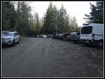
Chuckanut it as up to 36F. We arrived at the Two Dollar Trailhead at
8:05 am. The gate on the main road was open. We were the first car in
the lot. It looked like we would have some solitude to start. We
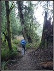
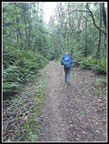
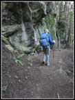
started hiking at 8:11 am. The trail begins with switchbacks climbing
up the slope. That was good to warm us up. The day was forecast to have
blue sky and it was crystal clear at the start. It is 1.7 miles to
Fragrance Lake. After the climb the route levels out with some ups and
downs along the way. We had a few spots with views out but most of the
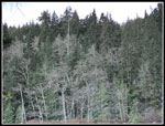
way is in forest. Saltwater is not far away.
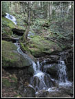
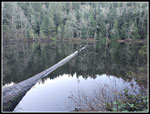
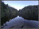
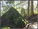
We reached the waterfall of the Fragrance Lake outlet creek at 8:44 am. In the summer and fall it does not have much flow. I have seen it much larger but this day it was looking good. We continued on the last short way to the lake. Near the lake the trail goes right alongside a big sandstone wall. We would see a lot more of this on the Rock Trail later. At the lake we turned left and continued on. There is a very good open spot with a look at most of the lake. It was completely calm on the lake. Reflection shots were crystal clear. We went around the lake and continued on. We met the first people of the day as they approached the lake from the trail up from Chuckanut Drive. At the road we turned right. This is the spot our lollipop route would take up back to later. In 2024 we were talking and missed the turn off to the left. This road continued down. When we saw big washout and a waterfall we knew we were on the wrong route. This time we paid attention and took the trail heading around Chuckanut Mountain below the Cyrus Gates Overlook.
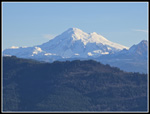
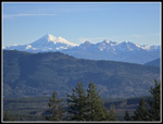
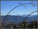
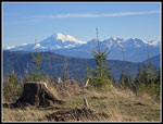
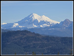
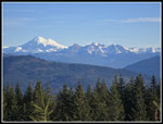
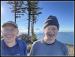
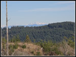
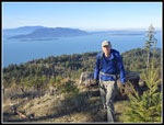
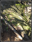
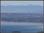
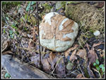
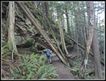
Much of the year this route has wildflowers or saprophytes, or mushrooms to see. In winter there is not much of anything. We did see some turkeytail fungus but not much more. The old road/trail has just a couple switchbacks as it traverses to the south. This section always seems longer than I expect. The map says it is 1.2 miles. We took a short break at the next junction. Left leads to Lost Lake and the Rock Trail. We went straight ahead. This route leads out to the viewpoints. First, we took the next road to the left. This brought us to a great view to the east. Samish Lake is below and Mt. Baker is ahead. With a clear sky we had a great look at Baker and the Twin Sisters Range. This is one of the best views of Baker from the west. It was still chilly but in the sunshine it felt great. Sun and very little breeze felt warm. We retraced our steps and turned left. At the high point several hikers were enjoying the view. We dropped a little and then headed up to Burnout Knob. We had lots of sunshine and great views here. It was hazy to the south but we could make out Mt. Rainier. It is a strange view of the Olympic Mountains. From Seattle, Mt. Zion is well north of The Brothers. From here Zion was left of The Brothers. We could see south along Hood Canal and west along the north side of the Olympic Range.
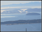
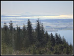
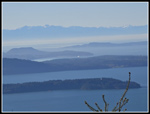
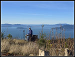
We arrived at 10:48 am. With an early start, we had no hurry to keep moving. It was foggy to the north in British Columbia. The San Juan Islands were sitting to the west. We could see Eliza Island with Lummi and Orcas Island behind it. It almost felt like spring. It was hard to get going again. Most of the rest of the day we would be in forest. At 12:13 pm we headed on. 1:25 made for a great long lunch break. We headed back to the junction. Here we turned right and headed for the Rock Trail. The route is almost all downhill. There were a few creeks running and one interesting small falls. Water was running down a groove in a small log and shooting up into the air. We saw several groups at Burnout Knob but none came tot he knob until we were leaving. On this leg we did finally pass several groups of hikers. At the Rock Trail junction we turned left and began to ascend. This trail is so interesting that we knew our pace would be very slow.
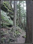
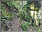
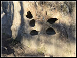
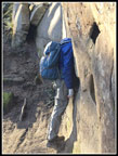
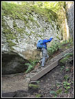
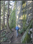
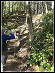
There is a rock cave. Big rocks are covered in moss and ferns. There are staircases and flat spots. The trail meanders right and left. Soon we reached the sandstone walls. At the headless hiker spot we each posed for headless photos. Holes in the rock are large enough to hide heads. There is so much green that it seems to cover everything but the vertical walls. The walls have dripping water and colorful lichen. There is plenty to photograph and enjoy. We finally reached the last stairs. The trail improbably climbs up more than half a dozen sets of stairs on a very steep hillside. At the top it is just a short walk to the Cyrus Gates Overlook. The view at the overlook is much smaller than a decade ago. Trees keep growing and minimizing the view. The lot was nearly full. This is a good spot for biker to start on the very steep drop to Chuckanut Drive. With my 10x zoom I could make out the skyscrapers of Vancouver to the north. It was hazier up there.
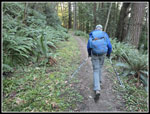
After a short break it was time to descend. The next leg is on the same Cleator Road we drove to the trailhead. Walking the whole road is not that pleasant. We walked .80 miles to a gated road on the left. There were several cars parked here. I had not seen any cars here previously. The road turning to trail drops to the end of our lollipop near Fragrance Lake. There are some big cedar trees alongside the trail. At the junction we turned right heading for the lake. Just before the lake, we turned left again and crossed a boardwalk through a marshy area. this route goes around the opposite side of the lake than our morning half loop. This side is above the lake with a near vertical sandstone wall alongside. It brought us back to where we reached the lake in the morning. Now we just had 1.7 miles back to the car. There always seems to be more uphill on the way back than expected. In a few open spots we had a last bit of warm sunshine. That last big drop brought us back to the trailhead at 3:29 pm. There were two cars parked next to me and one more across the road.
There were a few backups on the way home. It was a holiday for many but traffic was not wide open. Like many winter trips I left home in the dark and returned home just after dark. We wanted to get away from hikes on I-90 near Seattle but minimize snow. We wanted to take advantage of the clear sky to gt to a viewpoint for views and warm sunshine. Mission accomplished on both counts. Since nearby Western Washington University was on holiday I expected to see more hikers. We saw as many older retirees as we saw youngsters. Much of the day we had a lot of solitude. This trip has a loop and repeats part of the route. It has the Rock Trail which is always fun. It has a lake we saw coming and going. It also has a viewpoint where a recent clearcut has unleashed views from Mt. Rainier to Mt. Baker and Vancouver and the San Juan Islands. In another decade the trees will grow up to obscure the views but for now they are fantastic. For the day we hiked about 10.4 miles with 2300' of elevation gain.
Click on thumbnails to get
larger pictures.
Trips - 2026
Home
We reached the waterfall of the Fragrance Lake outlet creek at 8:44 am. In the summer and fall it does not have much flow. I have seen it much larger but this day it was looking good. We continued on the last short way to the lake. Near the lake the trail goes right alongside a big sandstone wall. We would see a lot more of this on the Rock Trail later. At the lake we turned left and continued on. There is a very good open spot with a look at most of the lake. It was completely calm on the lake. Reflection shots were crystal clear. We went around the lake and continued on. We met the first people of the day as they approached the lake from the trail up from Chuckanut Drive. At the road we turned right. This is the spot our lollipop route would take up back to later. In 2024 we were talking and missed the turn off to the left. This road continued down. When we saw big washout and a waterfall we knew we were on the wrong route. This time we paid attention and took the trail heading around Chuckanut Mountain below the Cyrus Gates Overlook.
Much of the year this route has wildflowers or saprophytes, or mushrooms to see. In winter there is not much of anything. We did see some turkeytail fungus but not much more. The old road/trail has just a couple switchbacks as it traverses to the south. This section always seems longer than I expect. The map says it is 1.2 miles. We took a short break at the next junction. Left leads to Lost Lake and the Rock Trail. We went straight ahead. This route leads out to the viewpoints. First, we took the next road to the left. This brought us to a great view to the east. Samish Lake is below and Mt. Baker is ahead. With a clear sky we had a great look at Baker and the Twin Sisters Range. This is one of the best views of Baker from the west. It was still chilly but in the sunshine it felt great. Sun and very little breeze felt warm. We retraced our steps and turned left. At the high point several hikers were enjoying the view. We dropped a little and then headed up to Burnout Knob. We had lots of sunshine and great views here. It was hazy to the south but we could make out Mt. Rainier. It is a strange view of the Olympic Mountains. From Seattle, Mt. Zion is well north of The Brothers. From here Zion was left of The Brothers. We could see south along Hood Canal and west along the north side of the Olympic Range.
We arrived at 10:48 am. With an early start, we had no hurry to keep moving. It was foggy to the north in British Columbia. The San Juan Islands were sitting to the west. We could see Eliza Island with Lummi and Orcas Island behind it. It almost felt like spring. It was hard to get going again. Most of the rest of the day we would be in forest. At 12:13 pm we headed on. 1:25 made for a great long lunch break. We headed back to the junction. Here we turned right and headed for the Rock Trail. The route is almost all downhill. There were a few creeks running and one interesting small falls. Water was running down a groove in a small log and shooting up into the air. We saw several groups at Burnout Knob but none came tot he knob until we were leaving. On this leg we did finally pass several groups of hikers. At the Rock Trail junction we turned left and began to ascend. This trail is so interesting that we knew our pace would be very slow.
There is a rock cave. Big rocks are covered in moss and ferns. There are staircases and flat spots. The trail meanders right and left. Soon we reached the sandstone walls. At the headless hiker spot we each posed for headless photos. Holes in the rock are large enough to hide heads. There is so much green that it seems to cover everything but the vertical walls. The walls have dripping water and colorful lichen. There is plenty to photograph and enjoy. We finally reached the last stairs. The trail improbably climbs up more than half a dozen sets of stairs on a very steep hillside. At the top it is just a short walk to the Cyrus Gates Overlook. The view at the overlook is much smaller than a decade ago. Trees keep growing and minimizing the view. The lot was nearly full. This is a good spot for biker to start on the very steep drop to Chuckanut Drive. With my 10x zoom I could make out the skyscrapers of Vancouver to the north. It was hazier up there.
After a short break it was time to descend. The next leg is on the same Cleator Road we drove to the trailhead. Walking the whole road is not that pleasant. We walked .80 miles to a gated road on the left. There were several cars parked here. I had not seen any cars here previously. The road turning to trail drops to the end of our lollipop near Fragrance Lake. There are some big cedar trees alongside the trail. At the junction we turned right heading for the lake. Just before the lake, we turned left again and crossed a boardwalk through a marshy area. this route goes around the opposite side of the lake than our morning half loop. This side is above the lake with a near vertical sandstone wall alongside. It brought us back to where we reached the lake in the morning. Now we just had 1.7 miles back to the car. There always seems to be more uphill on the way back than expected. In a few open spots we had a last bit of warm sunshine. That last big drop brought us back to the trailhead at 3:29 pm. There were two cars parked next to me and one more across the road.
There were a few backups on the way home. It was a holiday for many but traffic was not wide open. Like many winter trips I left home in the dark and returned home just after dark. We wanted to get away from hikes on I-90 near Seattle but minimize snow. We wanted to take advantage of the clear sky to gt to a viewpoint for views and warm sunshine. Mission accomplished on both counts. Since nearby Western Washington University was on holiday I expected to see more hikers. We saw as many older retirees as we saw youngsters. Much of the day we had a lot of solitude. This trip has a loop and repeats part of the route. It has the Rock Trail which is always fun. It has a lake we saw coming and going. It also has a viewpoint where a recent clearcut has unleashed views from Mt. Rainier to Mt. Baker and Vancouver and the San Juan Islands. In another decade the trees will grow up to obscure the views but for now they are fantastic. For the day we hiked about 10.4 miles with 2300' of elevation gain.
 Waterfall |
 Sandstone Near Lake |
 Smooth Reflection |
 Upside Down Reflection |
 Hiking Around Lake |
 Other Side Of Lake |
 Beyond Lake |
 First Mt. Baker View |
 Baker & Twin Sisters |
 Mt. Baker Framed |
 Baker From Burnout |
 Oil Refineries |
 Mt. Baker Close Up |
 Wider Angle View |
 Gary & Jim |
 Mt. Rainier |
 Canadian Peaks |
 Anacortes Ferry |
 Oyster Dome |
 Break Time For Gary |
 Gary At Burnout Knob |
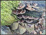 Turkey Tail Fungus |
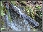 Spurting Falls |
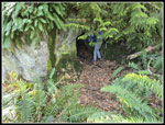 Rock Trail Cave |
 Mossy Rocks |
 Holy Rock |
 The Headless Hiker |
 Up The Stairs |
 Winding Trail |
 Vertical Wall |
 Shadow Pattern |
 The Final Stairs |
 Vancouver From Overlook |
 Overlook Parking Lot |
 Mounted Leaf |
 Heading For The Lake |
 Sandstone Above Lake |
 Splintered Tree |
Trips - 2026
Home