03-15-26
After
a very low snow winter we had a big storm in mid-March. Even the
lowlands had some snow. I joined Gary and John for our first snowshoe
trip of the year. We had snow along the road for much of the drive.
Nearing Snoqualmie Pass we saw the longest backup for the first two
summit exits we had ever seen. The poor snow season and the big dump
seemed have most skiers out for a chance to hit the slopes. Cars exited
at Hyak and then headed up the old road to the summit. We headed for
the Gold Creek Sno-Park to find 7 or 8 cars parked. We arrived at about
8:10 am and were packed and ready to go at 8:20 am. The road/trail
quickly had a freshly packed trench. A group of skiers and snowshoers
were in a circle talking when we arrived and were still there when we
started. There was clearly a lot of new snow. Hyak did not have much a
week ago. It was 28F and the snow was pretty firm on the compacted
track. On either side my pole sank in several feet. The trench was not
very deep at first. The road starts out flat and then turns left and
begins to climb. With little snow this winter we had not done many snow
trips. Our packs and boots were heavier than we were used to. Add on
four pounds of snowshoes. The road is not steep but climbs relentlessly.
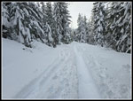
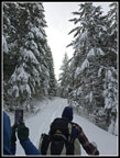
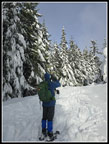
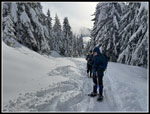
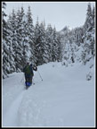
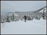
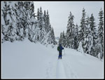
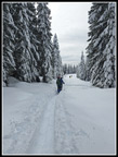
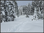
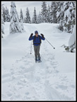
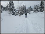
The heavily flocked trees were among the most scenic sights of the day. At about .75 miles we began to occasionally posthole. I fell down more than knee deep a couple times. That signaled that it was time to put on snowshoes. That helped a lot. Unfortunately, the snow softened a bit and we still occasionally postholed knee deep with snowshoes. A step at the edge of the deepening compacted trench led to more postholing. We saw one guy with a dog and starting a mile and a half or so up we were passed by the first of quite a few skiers. From 35 years ago when I started cross-country skiing until maybe 20 years ago we skied up to Kendall Lakes and saw other skiers but very few snowshoers. That has changed radically. Now we seldom see skiers on this road route. This day we saw some snowshoers but the sky crowd was much better represented. I hurt my knee last fall and it has been getting better slowly. I was concerned about snowshoeing with the heavy boots, heavy snowshoes, and heavy wet snow on the snowshoes. As it turned out, my knee was not a problem.
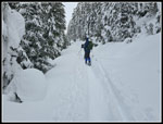
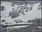
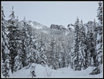
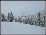
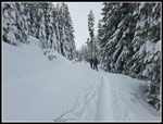
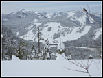
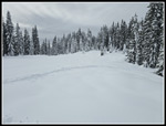
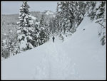
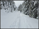
The route has several switchbacks before it heads up the valley of Coal Creek. In times past there was logging up here and some fine views. We still had some views but the trees are now blocking many of them. Before turning up the valley we did haves some views out to the ski areas across the highway and there were some seriously long lift lines. I was glad we were continuously in motion. I started with a windshirt but when the snowshoes went on it cam off. I was warm enough the rest of the day, Being passed was interesting as stepping out of the trench meant sinking down. We found a few places where people tromped down a rest spot beyond the trench and that helped with passing. We kept slogging along towards the sharp right turn that heads up to the ridge above. We arrived at 11:40 am. We had taken 2:20 to travel exactly 3 miles. Even with a couple food and water stops and putting on snowshoes that is very slow. Sinking down with many steps in the trench was slow.
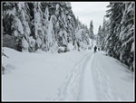
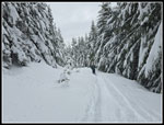
We took a longer break here. In the old days, the road also turned left here. It crossed the creek on a bridge and the road swichbacked up an open clearcut slope to a point across the valley. Now, we often go left, drop down to cross the creek, climb back up to the road and soon turn right and go cross-country up to Kendall Lakes. This day that would have been nearly impossible on snowshoes. Going uphill in 3-4 feet of unconsolidated fresh snow would have taken us hours to do a mile. After our break, we followed the road on a steeper grade up to the ridge top. There were a few spots along the way that had nice views out. The trench was still pretty good and we reached the ridge top at a better pace. Normally, the track follows the road ahead and a side track goes off right to Kendall Knob. We usually go to the Knob after visiting the lakes. This day there was no trench heading that way. It would have been a lot of effort to put one in on snowshoes. The route turned left before reaching that spot. It left the road and headed up in forest parallel to the road. We talked and decided to continue on the packed track. It zigged and zagged a bit and met up with the road once again. Some people had turned around at the our lunch spot and at the ridge top. There was still a trench but it was less packed down.
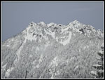
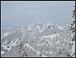
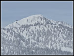
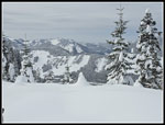
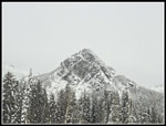
Though the day was forecast to be 100% overcast, we had some times of sunshine. It was warmer in the sun. On the ridge, we did have a little wind for the first time. We continued up the ridge to within a quarter mile or less of where the route heads into trees and on to the lower Kendall Lake. John had not bee out hiking much recently and I was concerned about my knee with downhill snowshoeing. We were at 3.7 miles and took one more break. Though it was mostly overcast, we had very good views out from this spot. Summit West was in sight with the lookout atop Granite mountain also seen. We had a partial view of Mt. Rainier but it was soon totally in clouds. It was 12:14 pm when we started down. It was probably above 32F all the way down. The track was a little softer but not all that bad. Quite a few people had come at least part of the way up and the track was better packed. On the way down I took quite a few short photo stops. I would work hard to catch up with Gary and John then stop for more photos. While we were at lunch a track was set at the start of the ridge on the road. We took our up route in forest again. We did follow the new track section to where we could see the open swath in forest where the route to Kendall Knob is located. There was still no track laid in.
Dropping down off the ridge went pretty fast. We maintained a much better pace going down. The last mile was a real slog. Even 7.4 miles in soft snow with snowshoes is a fell day's work. We were all a bit tired when we reached the car. For the day we traveled 7.4 miles with 1800' of elevation gain. That is about 3 hours or less on dirt but we took 6:02 including many photo stops and breaks. We arrived back at the car at 2:22 pm. All in all, it was really nice to have a day with heavily flocked trees and lots of fresh snow. It was hard work to travel in it but well worth the effort.
Click on thumbnails to get
larger pictures.
Trips - 2026
Home
The heavily flocked trees were among the most scenic sights of the day. At about .75 miles we began to occasionally posthole. I fell down more than knee deep a couple times. That signaled that it was time to put on snowshoes. That helped a lot. Unfortunately, the snow softened a bit and we still occasionally postholed knee deep with snowshoes. A step at the edge of the deepening compacted trench led to more postholing. We saw one guy with a dog and starting a mile and a half or so up we were passed by the first of quite a few skiers. From 35 years ago when I started cross-country skiing until maybe 20 years ago we skied up to Kendall Lakes and saw other skiers but very few snowshoers. That has changed radically. Now we seldom see skiers on this road route. This day we saw some snowshoers but the sky crowd was much better represented. I hurt my knee last fall and it has been getting better slowly. I was concerned about snowshoeing with the heavy boots, heavy snowshoes, and heavy wet snow on the snowshoes. As it turned out, my knee was not a problem.
The route has several switchbacks before it heads up the valley of Coal Creek. In times past there was logging up here and some fine views. We still had some views but the trees are now blocking many of them. Before turning up the valley we did haves some views out to the ski areas across the highway and there were some seriously long lift lines. I was glad we were continuously in motion. I started with a windshirt but when the snowshoes went on it cam off. I was warm enough the rest of the day, Being passed was interesting as stepping out of the trench meant sinking down. We found a few places where people tromped down a rest spot beyond the trench and that helped with passing. We kept slogging along towards the sharp right turn that heads up to the ridge above. We arrived at 11:40 am. We had taken 2:20 to travel exactly 3 miles. Even with a couple food and water stops and putting on snowshoes that is very slow. Sinking down with many steps in the trench was slow.
We took a longer break here. In the old days, the road also turned left here. It crossed the creek on a bridge and the road swichbacked up an open clearcut slope to a point across the valley. Now, we often go left, drop down to cross the creek, climb back up to the road and soon turn right and go cross-country up to Kendall Lakes. This day that would have been nearly impossible on snowshoes. Going uphill in 3-4 feet of unconsolidated fresh snow would have taken us hours to do a mile. After our break, we followed the road on a steeper grade up to the ridge top. There were a few spots along the way that had nice views out. The trench was still pretty good and we reached the ridge top at a better pace. Normally, the track follows the road ahead and a side track goes off right to Kendall Knob. We usually go to the Knob after visiting the lakes. This day there was no trench heading that way. It would have been a lot of effort to put one in on snowshoes. The route turned left before reaching that spot. It left the road and headed up in forest parallel to the road. We talked and decided to continue on the packed track. It zigged and zagged a bit and met up with the road once again. Some people had turned around at the our lunch spot and at the ridge top. There was still a trench but it was less packed down.
Though the day was forecast to be 100% overcast, we had some times of sunshine. It was warmer in the sun. On the ridge, we did have a little wind for the first time. We continued up the ridge to within a quarter mile or less of where the route heads into trees and on to the lower Kendall Lake. John had not bee out hiking much recently and I was concerned about my knee with downhill snowshoeing. We were at 3.7 miles and took one more break. Though it was mostly overcast, we had very good views out from this spot. Summit West was in sight with the lookout atop Granite mountain also seen. We had a partial view of Mt. Rainier but it was soon totally in clouds. It was 12:14 pm when we started down. It was probably above 32F all the way down. The track was a little softer but not all that bad. Quite a few people had come at least part of the way up and the track was better packed. On the way down I took quite a few short photo stops. I would work hard to catch up with Gary and John then stop for more photos. While we were at lunch a track was set at the start of the ridge on the road. We took our up route in forest again. We did follow the new track section to where we could see the open swath in forest where the route to Kendall Knob is located. There was still no track laid in.
Dropping down off the ridge went pretty fast. We maintained a much better pace going down. The last mile was a real slog. Even 7.4 miles in soft snow with snowshoes is a fell day's work. We were all a bit tired when we reached the car. For the day we traveled 7.4 miles with 1800' of elevation gain. That is about 3 hours or less on dirt but we took 6:02 including many photo stops and breaks. We arrived back at the car at 2:22 pm. All in all, it was really nice to have a day with heavily flocked trees and lots of fresh snow. It was hard work to travel in it but well worth the effort.
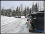 Gold Creek Sno-Park |
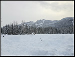 View From Sno-Park |
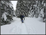 Booting It |
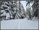 Flocked Trees |
 Ski Tracks |
 John Taking Photo |
 John At Work |
 Snow Sculpture |
 John & Jim |
 Passed By Skiers |
 Lots Of Skiers |
 Snowy Peaks |
 Shady Snowshoeing |
 Peaks Above Lakes |
 More Peaks |
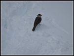 Camp Robber Jay |
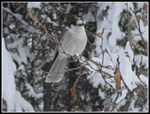 Jay Close Up |
 Ascending To Ridge Top |
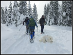 Snow Dog |
 Even More Peaks |
 Gary On Ridge |
 Ski Slopes Again |
 Granite Mt. Lookout |
 Icicle |
 Descending Ridge |
 View South |
 Ridge Roaming |
 Route To Knob |
 Sunshine! |
 Here Comes Gary! |
 Leaving The Ridge |
 Packed Trench |
 Taking More Photos |
 Getting Near The End |
 The Snow May Not Last |
 Blue & White |
 Guye Peak |
Trips - 2026
Home