03-29-26
Gary
was free for a Sunday hike. It
looked pretty wet everywhere. By Friday evening the rain looked like it
might hold off until about 11:00 am close to Seattle. We settled on an
early start for a trip on Squak Mountain starting at the Margaret's Way
trailhead. Reports a week earlier talked about a dozen small trees down
across the trail. We had no idea if they had been cleared so I brought
a small saw. We met in North Seattle at 7:00 am and headed east. We
arrived at the trailhead to find only two cars in the lot. Two more
arrived soon after. It was overcast but dry. The forecast now had rain
arriving at around 12:30 pm. We planned for a short hike but left open
the opportunity to make it a bit longer. This would be my last hike of
the first quarter of the year. I was just over my 200 mile pace but
2600' short of 50,000'. With a Squak Mountain high point of only about
2000', the elevation goal looked to be too far away. At 7:34 am we
headed up the trail. It was a cold but not freezing morning.
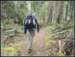
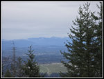
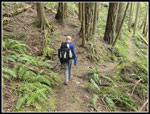
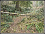
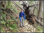
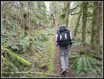
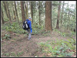
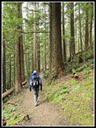
The trail starts on a road that used to go through the old campground. It turns to trail then back to road. The junctions are marked to keep you on track. We left the road after about half a mile. The trail soon has passes a viewpoint. A runner went by us head up here. The sky was white but we had a bit of a view. Next came the only mushrooms of the day. Just one small patch of them. At the next viewpoint, we took the short trail over to it, arriving at 8:09 am. Normally, you can see the Olympic Mountains but not today. The trail has some ups and downs then begins a steady climb. The first .70 miles of the trail is a bit rocky and rooty. The built trail is pretty smooth. We looked for and found the spot off the trail where we see fawn lily flowers in the spring. We saw leaves but no flowers or buds are out yet. The trail switchbacks higher than traverses over to the ridge top. We could head across to the Chybinski Trail down the north side of Squak or head right. We decided to head right. The next junction has a trail that goes over West Peak. That would be on our route out. We went right heading for Debbie's View. We did not expect to see Mt. Rainier through the clouds but it was early enough we might not have a crowd. A few minutes later we arrived at Debbie's view at 9:11 am. We had close in views but no mountains.
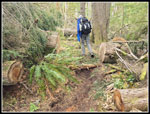
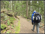
We took a short break and headed back to the Perimeter Trail. We could go left and over West Peak or right and meet the Bullitt Gorge Trail coming up from the state park. We went right and downhill. At the next junction we went left and uphill heading for the Bullitt Fireplace. The trail passes the other end of the trail over West Peak and meets an old road to the Bullitt Cabin. We climbed the road to reach the Fireplace, all that is left of the old cabin. Two guys with babies were at the picnic table. We said hi and kept moving. On the trail to Debbie's View all the down logs had been very recently cut out. at the Fireplace we took a minute to pull a bunch of branches off the trail. There was no more recent log cutting on our route from here. We took the ridge route over to Central Peak. On the way we found a small tree with a lot of branches over the trail. We set to work cutting off the branches and cutting the tree. Soon, the trail was clear. A little farther, we found a bigger tree down and but that one out.
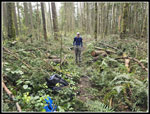
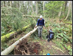
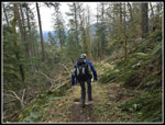
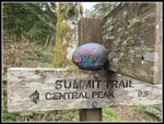
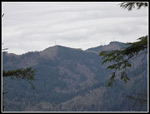
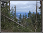
We continued to Central Peak, arriving at 11:14 am. We had now covered 5.5 miles. This was looking to be a longer day than planned. I might get close to 50,000' of gain for the quarter. The Doppler radar showed lots of rain coming but it was not yet close. Heading straight back was the smart thing to do. I joked to Gary that a year earlier we did a similar trip and then went down the summit trail to Phil's Creek Trail and up the Old Griz Trail. Gary thought that was a fine idea. I guess we would be going even farther. We dropped down the road and onto the Summit Trail. It is very steep and we come up it far more than down. The traction was good and we slowly descended. Another log was across the trail. We stopped to cut off a bunch of branches and make it an easy step across. At the bottom we turned left on Phil's Creek Trail. The Bomb Cyclone from 16 months earlier took day a lot of trees. We now had a view across to the summits of Tiger 1, 2, & 3. We reached the Old Griz Trail had began to regain all the elevation we had lost. This added a good chunk of the elevation I had hoped to gain. The Old Griz has changed post Bomb Cyclone from a deep forest to an open area with lots of down trees. It took some time to cut the trail back open.
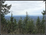
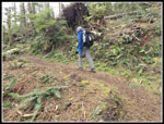
At the top we were near the top of Central Peak again. We went right downhill then uphill back to the Fireplace. We dropped down the road and onto the trail over West Peak. It is really steep in places. We went over one peak then another, and a third. We then dropped down to complete our loop, At the junction we went right and back to the top of Margaret's Way Trail. It was now 12:26 pm and the rain had not started yet. We had already covered 7.4 miles. The trail is moderately graded making it great for the downhill. We started to see some more hikers and runners. We saw a few groups in the morning and more on the rest of the way down. At the viewpoint off the main trail we headed over there again. Adding that would get us almost up to 11 miles on the day. There was still no view. A little before that we felt a few raindrops falling. It was so light we did not take out umbrellas. Our stop was very short. At the last viewpoint just off the trail we stopped again. There was still not much of a view. Now we were less under .80 miles to go. At .60 miles, Gary slipped on a loose rock and fell. From his reaction it was not just a minor slip. He could not get up. We waited a bit and tried again. He walked a short way and that was it. It was time to call for help.
Gary reached 911 and reported the situation. The Fire Department was much closer than Search & Rescue to they were notified. After talking we decided that I would head down the the trailhead to help them find Gary. It was now starting to rain but Gary had rain gear and an umbrella. I reached the trailhead in about 12 minutes and the Fire Department was already there. They did not have a key to the gate so were in the process of cutting off the lock. The road up to Gary uses to be obvious but the trail was routed off the road and meets it again a little higher. the main road heads off right after the dirt trail begins. I was not sure if it would meet up with the road/trail above. I ended up in the rescue truck with my GPS for navigation. The old road heading right is no longer on the GPS map. We followed the road and I could see that we would reach a trail that headed near to where Gary was waiting. We actually parked within about .20 miles of Gary. Best of all, we were not far below elevation wise. The road/trail is steep and rocky. Our short trail was much easier to evacuate him.
After reaching Gary, the firefighter checked him out and applied a blow up splint. Instead of using the wheeled gurney, they decided to put him on a sort of sheet with hand grab spots on both sides. They lifted him and carried him back to the truck this way. It all went very quickly. By 3:05 he was back at the trailhead. They could take him to a hospital emergency room but not to orthopedic urgent care. They did lift him into the back of his car for a short drive to Issaquah. We spent almost 3 hours in urgent care while they x-rayed and scanned his knee. The bad news is he is likely off the trail for several months. At least he now had a solid brace on that allowed him to walk slowly.
This was a great hike where we went farther with more elevation gain than planned and we would have made it out before the rain came. Unfortunately, there was an accident. The Fire Department crew arrived fast and did a great job getting Gary off the trail an on his way to treatment. Accidents on trail are rare but they can happen. That is why we have more clothing and equipment on a trail than is usually needed. That is why I have a personal locater beacon in case there is no cell phone service. One twist of the trip was that my hike out and then the hike up from the truck to Gary and back put me just over 11 miles with 3000' of gain. That put me over 50,000' of gain for the quarter and gave me my first 3,000' gain day of the year. The end of the trip was a big letdown but the hike itself was a lot of fun.
Click on thumbnails to get
larger pictures.
Trips - 2026
Home
The trail starts on a road that used to go through the old campground. It turns to trail then back to road. The junctions are marked to keep you on track. We left the road after about half a mile. The trail soon has passes a viewpoint. A runner went by us head up here. The sky was white but we had a bit of a view. Next came the only mushrooms of the day. Just one small patch of them. At the next viewpoint, we took the short trail over to it, arriving at 8:09 am. Normally, you can see the Olympic Mountains but not today. The trail has some ups and downs then begins a steady climb. The first .70 miles of the trail is a bit rocky and rooty. The built trail is pretty smooth. We looked for and found the spot off the trail where we see fawn lily flowers in the spring. We saw leaves but no flowers or buds are out yet. The trail switchbacks higher than traverses over to the ridge top. We could head across to the Chybinski Trail down the north side of Squak or head right. We decided to head right. The next junction has a trail that goes over West Peak. That would be on our route out. We went right heading for Debbie's View. We did not expect to see Mt. Rainier through the clouds but it was early enough we might not have a crowd. A few minutes later we arrived at Debbie's view at 9:11 am. We had close in views but no mountains.
We took a short break and headed back to the Perimeter Trail. We could go left and over West Peak or right and meet the Bullitt Gorge Trail coming up from the state park. We went right and downhill. At the next junction we went left and uphill heading for the Bullitt Fireplace. The trail passes the other end of the trail over West Peak and meets an old road to the Bullitt Cabin. We climbed the road to reach the Fireplace, all that is left of the old cabin. Two guys with babies were at the picnic table. We said hi and kept moving. On the trail to Debbie's View all the down logs had been very recently cut out. at the Fireplace we took a minute to pull a bunch of branches off the trail. There was no more recent log cutting on our route from here. We took the ridge route over to Central Peak. On the way we found a small tree with a lot of branches over the trail. We set to work cutting off the branches and cutting the tree. Soon, the trail was clear. A little farther, we found a bigger tree down and but that one out.
We continued to Central Peak, arriving at 11:14 am. We had now covered 5.5 miles. This was looking to be a longer day than planned. I might get close to 50,000' of gain for the quarter. The Doppler radar showed lots of rain coming but it was not yet close. Heading straight back was the smart thing to do. I joked to Gary that a year earlier we did a similar trip and then went down the summit trail to Phil's Creek Trail and up the Old Griz Trail. Gary thought that was a fine idea. I guess we would be going even farther. We dropped down the road and onto the Summit Trail. It is very steep and we come up it far more than down. The traction was good and we slowly descended. Another log was across the trail. We stopped to cut off a bunch of branches and make it an easy step across. At the bottom we turned left on Phil's Creek Trail. The Bomb Cyclone from 16 months earlier took day a lot of trees. We now had a view across to the summits of Tiger 1, 2, & 3. We reached the Old Griz Trail had began to regain all the elevation we had lost. This added a good chunk of the elevation I had hoped to gain. The Old Griz has changed post Bomb Cyclone from a deep forest to an open area with lots of down trees. It took some time to cut the trail back open.
At the top we were near the top of Central Peak again. We went right downhill then uphill back to the Fireplace. We dropped down the road and onto the trail over West Peak. It is really steep in places. We went over one peak then another, and a third. We then dropped down to complete our loop, At the junction we went right and back to the top of Margaret's Way Trail. It was now 12:26 pm and the rain had not started yet. We had already covered 7.4 miles. The trail is moderately graded making it great for the downhill. We started to see some more hikers and runners. We saw a few groups in the morning and more on the rest of the way down. At the viewpoint off the main trail we headed over there again. Adding that would get us almost up to 11 miles on the day. There was still no view. A little before that we felt a few raindrops falling. It was so light we did not take out umbrellas. Our stop was very short. At the last viewpoint just off the trail we stopped again. There was still not much of a view. Now we were less under .80 miles to go. At .60 miles, Gary slipped on a loose rock and fell. From his reaction it was not just a minor slip. He could not get up. We waited a bit and tried again. He walked a short way and that was it. It was time to call for help.
Gary reached 911 and reported the situation. The Fire Department was much closer than Search & Rescue to they were notified. After talking we decided that I would head down the the trailhead to help them find Gary. It was now starting to rain but Gary had rain gear and an umbrella. I reached the trailhead in about 12 minutes and the Fire Department was already there. They did not have a key to the gate so were in the process of cutting off the lock. The road up to Gary uses to be obvious but the trail was routed off the road and meets it again a little higher. the main road heads off right after the dirt trail begins. I was not sure if it would meet up with the road/trail above. I ended up in the rescue truck with my GPS for navigation. The old road heading right is no longer on the GPS map. We followed the road and I could see that we would reach a trail that headed near to where Gary was waiting. We actually parked within about .20 miles of Gary. Best of all, we were not far below elevation wise. The road/trail is steep and rocky. Our short trail was much easier to evacuate him.
After reaching Gary, the firefighter checked him out and applied a blow up splint. Instead of using the wheeled gurney, they decided to put him on a sort of sheet with hand grab spots on both sides. They lifted him and carried him back to the truck this way. It all went very quickly. By 3:05 he was back at the trailhead. They could take him to a hospital emergency room but not to orthopedic urgent care. They did lift him into the back of his car for a short drive to Issaquah. We spent almost 3 hours in urgent care while they x-rayed and scanned his knee. The bad news is he is likely off the trail for several months. At least he now had a solid brace on that allowed him to walk slowly.
This was a great hike where we went farther with more elevation gain than planned and we would have made it out before the rain came. Unfortunately, there was an accident. The Fire Department crew arrived fast and did a great job getting Gary off the trail an on his way to treatment. Accidents on trail are rare but they can happen. That is why we have more clothing and equipment on a trail than is usually needed. That is why I have a personal locater beacon in case there is no cell phone service. One twist of the trip was that my hike out and then the hike up from the truck to Gary and back put me just over 11 miles with 3000' of gain. That put me over 50,000' of gain for the quarter and gave me my first 3,000' gain day of the year. The end of the trip was a big letdown but the hike itself was a lot of fun.
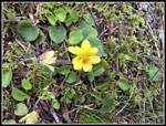 A Yellow Violet |
 Campground Turnaround |
 First Viewpoint |
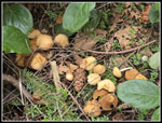 Mushrooms |
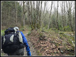
 Gary On The Trail |
 Debbie's View |
 Debbie's Again |
 On The Perimeter Trail |
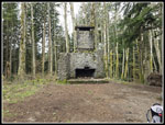 Bullitt Fireplace |
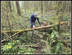 Log Partly Cut |
 Log Has Been Removed |
 Before The Cuts |
 Branches Removed |
 Summit Trail Descent |
 Colorful Flowers |
 Tigers 3-2-1 |
 Gary On Phils Creek Trail |
 Logs On Old Griz |
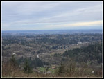
 Lake Sammamish |
 Gary On Old Griz Trail |
 Nearing Fireplace |
 Bare Tree |
 Between WP Summits |
 Descending West Peak |
 On Margaret's Way Trail |
 Red Currant |
 Near 2nd Viewpoint |
 Bench At Viewpoint |
Trips - 2026
Home