11-28-04
Note to self: Always check the topo lines carefully.
This had been a lousy hiking month as I had only been able to get out two times. I wanted to make the most of my final trip. Gary was free and he also wanted to get in a good workout. The forecast was for sunny and cold weather. We wanted a good long trip with enough elevation gain to reach a good viewpoint. Gary suggested Polallie Ridge. We did a loop trip over Polallie Ridge, to the lookout, down Tired Creek, and back via the Cooper River Trail about half a dozen years ago. I have been to the lookout site via Tired Creek numerous times but that loop trip was the only time I had been on the rest of the ridge. The trailhead near Salmon La Sac is at 2400'. The lookout site is some 6 1/4 miles away at 5482". A gain of 3100' sounded good. The views from the lookout site are outstanding. Even with a little recent snow we were confident we would be able to drive to the trailhead on bare road. We were also hoping to climb a mile or more before hitting snow.
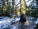
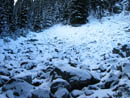
The days are short at the end of November so we arranged to meet in Issaquah at 6:30 am. It was still dark until we neared Snoqualmie Pass. We were not surprised to see no other cars at the trailhead. By 8:15 we were on our way. The trailhead was snow free. We quickly passed the Cooper River and Waptus Lake trails and began to head up the ridge. This trail has few switchbacks as it ascends the ridge. It is not steep but is very consistent as it quickly gains elevation. Snow patches began very soon but the trail was largely bare up to about 3600'. We saw two sets of fresh footprints in the snow, likely from the day before. We had a few short views of Red Mountain to the south through the trees.
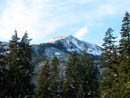
The trail did not seem steep but we gained 950' in the first mile. The second mile gained another 850'. Just beyond there at about 4300' we had a view out to Davis Peak. At 5150' the trail began to drop. We had a view of Mt. Daniel from there. This drop turned out to be the first of many roller coaster sections. We carried snowshoes but hoped to keep them on our backs as long as possible. The trail was completely covered after the first few miles but not difficult to follow. We also had those footprints guiding the way. Shortly after beginning I took a temperature reading and it showed about 32 degrees. As we rose it grew colder and most of the rest of the day was in the mid 20s. The trail continued to make short gains and drops until we dropped down to a big snow covered meadow at 3 miles. This is where our trail makers turned around. For the rest of the trip we would have to do our own route finding.
On my only previous time there I vaguely remembered angling right then crossing the meadow. There was a rock cairn marking the trail on the other side. Gary thought he saw a blaze on a tree so we headed that way. In fact, he was correct as we found a snowy rock pile and large blaze on a tree. Our route again climbed several hundred feet then dropped down again. At 3.8 miles we reached Diamond Lake. The lake was frozen and covered with a coat of blazing white snow. The sunshine on the snow was very bright. We lost the trail after crossing the inlet stream. When the route along the shore reached uncut logs we were almost positive we were off route. We stopped to pull out both my GPS and map. I had previously entered 7 waypoints and Diamond Lake was one. Trusting the map we could see we were off track and turned left. After a short slog we reached the route again, now under a few feet of snow.
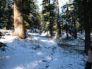
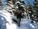
The route climbed yet again then took another descent. Although the snow was never deep enough to require snowshoes we were making ridiculously slow progress. Calculating our pace and the distance remaining to the lookout site it was becoming obvious we could not make it and get back before dark. We set 1:00 as a turn around time and continued on. We also calculated that this trip was going to be over 4000' gained, not 3100'. Another up and down brought us to another meadow which we crossed without losing the route. Gary did a great job of keeping us on the summer trail even when the snow covered all traces. Soon we would find another blaze confirming we were on track. A final descent brought us to another snowy meadow. It was now noon and we needed to take a lunch break. The GPS confirmed that we were at waypoint 6 and that the lookout site was still just over a mile away in a straight line. On dirt we would be there in 20+ minutes. On this snow it would be more like 40 minutes.
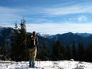
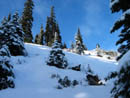
Above the meadow was a mostly bare spot on the crest of the ridge. It was about 600' above us. A check showed that the trail climbed up to the crest. We decided to follow the route and then make a bee line for the crest. It looked to have a mostly clear view. We left the trail a few hundred feet below the top and scrambled up to the crest. We were disappointed to see that clouds had come in to the south and west. The ridge had hid this fact from us. Mt. Stuart, The Cradle, and Davis Peak were clear to the east and northeast. Trees blocked straight north hiding Mt. Daniel and Hinman. Bears Breast was in the clear along with Dutch Miller Gap. Just south of them the Chiefs were in the clouds. I could see the lower half of Little Big Chief but not the top. For a very brief second Three Queens Mountain appeared while completely surrounded by clouds. The views were good but a few hours earlier they would have been outstanding.
We spent half an hour on top at 5540'. Our viewpoint was actually about 50' higher than the lookout site down the ridge. It was 1:10 when we headed down. It was clear that we would not be back before sunset but we hoped to be off the snow. On the way back we used altimeters to measure all those gains. With our own footprints to follow we did not have any route finding slowdowns. The going still was slower than we usually manage. By sunset we were only 600' above the trailhead. We held off on headlamps and finally made it back at 5:00 pm in total darkness. We saw no other footprints coming back. It was not too surprising that nobody else was on this trail this day. The total distance was 11 miles and after adding up all the ups and downs our 3100' planned gain ended up being 5300'. That's a pretty hefty gain in the snow.
This is a seldom visited trail any time of year. It has a lake and a great viewpoint at the old lookout site. The trailhead is less than a mile from pavement. It proved to be a great workout in the snow. I really like the long loop via Cooper Lake but out and back on Polallie Ridge turned out to be a great place to be for a sunny hike in the snow.
Click on thumbnails to get larger pictures.
Photo Page 2
Trips - 2004
Home
This had been a lousy hiking month as I had only been able to get out two times. I wanted to make the most of my final trip. Gary was free and he also wanted to get in a good workout. The forecast was for sunny and cold weather. We wanted a good long trip with enough elevation gain to reach a good viewpoint. Gary suggested Polallie Ridge. We did a loop trip over Polallie Ridge, to the lookout, down Tired Creek, and back via the Cooper River Trail about half a dozen years ago. I have been to the lookout site via Tired Creek numerous times but that loop trip was the only time I had been on the rest of the ridge. The trailhead near Salmon La Sac is at 2400'. The lookout site is some 6 1/4 miles away at 5482". A gain of 3100' sounded good. The views from the lookout site are outstanding. Even with a little recent snow we were confident we would be able to drive to the trailhead on bare road. We were also hoping to climb a mile or more before hitting snow.
The days are short at the end of November so we arranged to meet in Issaquah at 6:30 am. It was still dark until we neared Snoqualmie Pass. We were not surprised to see no other cars at the trailhead. By 8:15 we were on our way. The trailhead was snow free. We quickly passed the Cooper River and Waptus Lake trails and began to head up the ridge. This trail has few switchbacks as it ascends the ridge. It is not steep but is very consistent as it quickly gains elevation. Snow patches began very soon but the trail was largely bare up to about 3600'. We saw two sets of fresh footprints in the snow, likely from the day before. We had a few short views of Red Mountain to the south through the trees.
The trail did not seem steep but we gained 950' in the first mile. The second mile gained another 850'. Just beyond there at about 4300' we had a view out to Davis Peak. At 5150' the trail began to drop. We had a view of Mt. Daniel from there. This drop turned out to be the first of many roller coaster sections. We carried snowshoes but hoped to keep them on our backs as long as possible. The trail was completely covered after the first few miles but not difficult to follow. We also had those footprints guiding the way. Shortly after beginning I took a temperature reading and it showed about 32 degrees. As we rose it grew colder and most of the rest of the day was in the mid 20s. The trail continued to make short gains and drops until we dropped down to a big snow covered meadow at 3 miles. This is where our trail makers turned around. For the rest of the trip we would have to do our own route finding.
On my only previous time there I vaguely remembered angling right then crossing the meadow. There was a rock cairn marking the trail on the other side. Gary thought he saw a blaze on a tree so we headed that way. In fact, he was correct as we found a snowy rock pile and large blaze on a tree. Our route again climbed several hundred feet then dropped down again. At 3.8 miles we reached Diamond Lake. The lake was frozen and covered with a coat of blazing white snow. The sunshine on the snow was very bright. We lost the trail after crossing the inlet stream. When the route along the shore reached uncut logs we were almost positive we were off route. We stopped to pull out both my GPS and map. I had previously entered 7 waypoints and Diamond Lake was one. Trusting the map we could see we were off track and turned left. After a short slog we reached the route again, now under a few feet of snow.
The route climbed yet again then took another descent. Although the snow was never deep enough to require snowshoes we were making ridiculously slow progress. Calculating our pace and the distance remaining to the lookout site it was becoming obvious we could not make it and get back before dark. We set 1:00 as a turn around time and continued on. We also calculated that this trip was going to be over 4000' gained, not 3100'. Another up and down brought us to another meadow which we crossed without losing the route. Gary did a great job of keeping us on the summer trail even when the snow covered all traces. Soon we would find another blaze confirming we were on track. A final descent brought us to another snowy meadow. It was now noon and we needed to take a lunch break. The GPS confirmed that we were at waypoint 6 and that the lookout site was still just over a mile away in a straight line. On dirt we would be there in 20+ minutes. On this snow it would be more like 40 minutes.
Above the meadow was a mostly bare spot on the crest of the ridge. It was about 600' above us. A check showed that the trail climbed up to the crest. We decided to follow the route and then make a bee line for the crest. It looked to have a mostly clear view. We left the trail a few hundred feet below the top and scrambled up to the crest. We were disappointed to see that clouds had come in to the south and west. The ridge had hid this fact from us. Mt. Stuart, The Cradle, and Davis Peak were clear to the east and northeast. Trees blocked straight north hiding Mt. Daniel and Hinman. Bears Breast was in the clear along with Dutch Miller Gap. Just south of them the Chiefs were in the clouds. I could see the lower half of Little Big Chief but not the top. For a very brief second Three Queens Mountain appeared while completely surrounded by clouds. The views were good but a few hours earlier they would have been outstanding.
We spent half an hour on top at 5540'. Our viewpoint was actually about 50' higher than the lookout site down the ridge. It was 1:10 when we headed down. It was clear that we would not be back before sunset but we hoped to be off the snow. On the way back we used altimeters to measure all those gains. With our own footprints to follow we did not have any route finding slowdowns. The going still was slower than we usually manage. By sunset we were only 600' above the trailhead. We held off on headlamps and finally made it back at 5:00 pm in total darkness. We saw no other footprints coming back. It was not too surprising that nobody else was on this trail this day. The total distance was 11 miles and after adding up all the ups and downs our 3100' planned gain ended up being 5300'. That's a pretty hefty gain in the snow.
This is a seldom visited trail any time of year. It has a lake and a great viewpoint at the old lookout site. The trailhead is less than a mile from pavement. It proved to be a great workout in the snow. I really like the long loop via Cooper Lake but out and back on Polallie Ridge turned out to be a great place to be for a sunny hike in the snow.
Fisrt Snow |
Red Mountain |
Snow Covered Trail |
4300' Viewpoint |
Rock Field |
Deeper Snow |

Diamond Lake |

Snowy Meadow |

Another Meadow |
Ridge Scramble |
Photo Page 2
Trips - 2004
Home