7-11-04
Three Brothers is one of my favorite
scrambles. I had just done it last year and didn't plan to do it again so
soon. However, Jay and Lindy Bruce were leading it as a Mountaineer scramble
and I had not seen then in a few years. The weather was looking very good
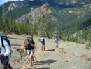
for the east side so I signed up. We met at the Stafford Creek trailhead
at 8:00 am and were on the trail by 8:15. The route they chose was a little
different from any I had done before. This would be the fourth different
route I have taken to Three Brothers. There was an option to include Navaho
Peak on the return. I doubted that I would have the energy to bag it after
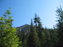
over 5000' of gain. The Stafford Creek trail is very nice with a very moderate
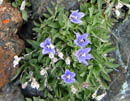
grade. The one thing it does not offer is a good wildflower display. At least
not before this day. After the first couple of miles we came upon large
fields of wildflowers. Lupine was especially abundant. Gilia and paintbrush
added reds and a few dozen other flowers added yellow and white. I have hiked
this trail during many different months and never seen a fraction of the
flowers that were on display.
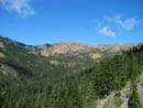
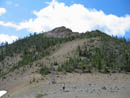
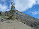
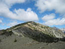
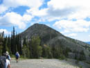
At about 3 1/2 miles we came to the lone creek crossing of any size. Just before the creek we headed straight up the slope. I have headed up on the other side of the creek but never here. It proved to be a pretty easy route. There was no underbrush and no downed logs. We slowly worked our way up towards a pass above. We needed to climb 1200' to the pass at 6000'. As we rose above the trees we could see out to Earl Peak. In short order we arrived at the pass. Little Navaho Peak was less than 500' above up to the east. At the pass we had several choices. We could head down the other side into the Negro Creek valley then hike up to Falls Creek Pass. We could try to contour around the ridge to the west. Lastly, we could climb up the westerly ridge and intersect the County Line Trail where it crosses the ridge below Navaho Peak. The traverse looked a little iffy with poor footing and some exposure. We headed up the ridge to look for a better place to traverse. Not finding one, we continued up the ridge. A bootpath leads around any problem spots and works easily to the flat ridge top. A short walk took us to the County Line Trail.
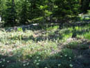
One party member was not feeling 100 percent so he and Lindy stayed at the pass while the other 8 of us headed down towards Falls Creek Pass. The trail down passes through a marshy area. There are often flowers there. After the first big drop the grade eases and the flowers began. Larkspur, lupine, and paintbrush at first. In the marshy spot we found shooting starts and elephant heads. The latter is a flower I seldom see but have now seen three times in the past 8 days. We quickly reached the pass where the Falls Creek Trail drops down to Ingalls Creek to the north and the Negro Creek trail drops to the south. Going straight ahead leads up the ridge to the summit of the highest peak of Three Brothers. The pass and lower ridge of Three Brothers were covered in blooming balsamroot, lupine, paintbrush, and many more flowers I couldn't name. The scramble gains 1300' from the 6000' pass in about 8/10 of a mile. It is not difficult but is a real grind. We had already gained 3600' before this climb. The day had started out with all blue skies but clouds had quickly moved in. This was good as it kept the temperature down. We also had a cool breeze blowing. The route climbs at a steady grade until just a few hundred feet below the top where the grade lessens. The actual summit is a little bump on a nearly level ridge. It was 12:20 when we reached the summit and time for a well deserved lunch. It took us about 45 minutes to come up from the pass.
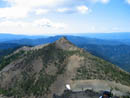
The top of Mt. Stuart was in the clouds but otherwise the view was excellent. We could see the Cascade crest near Lemah and Chimney Rock. Earl, Miller, Navaho, and Ingalls were visible. All the peaks of the Stuart Range were close by. Little Annapurna and McClellan were just across Ingalls Creek from us. Even Hibox, Alta, and Three Queens were seen in the distance. Adams was clear but Rainier was in the clouds. After about 25 minutes it was time to head on down. There is enough of a bootpath that I usually can follow it up. I have never been able to follow it back down again. This time was no different. We managed to get a little too far right and had to scramble a bit to get back on route. Soon we were back at the pass. Now with 4900' under our belts we had to climb about 600' back to the Navaho Peak ridge. Surprisingly, the whole group was still in good shape and making good time.
Back on the ridge top we met up with our other two party members. Susan had been up Navaho earlier this spring but had not done the County Line Trail around Navaho. She chose to take that new trail. The rest of us turned up the ridge for the 600' climb to the top of Navaho. The ridge had more new flowers including some bitterroot. Once on top of Navaho I finished most of my food to fuel up for the final 7 miles back to the cars. The view from Navaho was similar to Three Brothers but was closer to Stuart and now included Mt. Daniel. Daniel still has lots of snow. Stuart had now come out of the clouds. Coming down from Navaho was a lot harder on my knees than my May visit when there was still snow down almost to Navaho Pass.
Just below the pass we met Susan. Considering the distance, elevation gain, and general knee pounding the whole group was still going strong. At one point a deer walked across the trail ahead of us. It stayed just above the trail as we walked by. Speaking of fauna, we also saw a western tanager and a bluebird (Thanks to Susan for the IDs). We made it back to the trailhead at about 5:45. It was a long 9 1/2 hour day covering 15 miles with 6000' of elevation gain. While I have been over 5000' numerous times, this was only my second 6000' day. This wrapped up an 8 day period where I covered 42 miles and gained 17,600'. I just may need a short break to recuperate. It turned out to be a great day. Perfect weather, a partially new route, two nice summits, and good company.
Click on thumbnails to get larger pictures.
Photo Page 2
Trips - 2004
Home
At about 3 1/2 miles we came to the lone creek crossing of any size. Just before the creek we headed straight up the slope. I have headed up on the other side of the creek but never here. It proved to be a pretty easy route. There was no underbrush and no downed logs. We slowly worked our way up towards a pass above. We needed to climb 1200' to the pass at 6000'. As we rose above the trees we could see out to Earl Peak. In short order we arrived at the pass. Little Navaho Peak was less than 500' above up to the east. At the pass we had several choices. We could head down the other side into the Negro Creek valley then hike up to Falls Creek Pass. We could try to contour around the ridge to the west. Lastly, we could climb up the westerly ridge and intersect the County Line Trail where it crosses the ridge below Navaho Peak. The traverse looked a little iffy with poor footing and some exposure. We headed up the ridge to look for a better place to traverse. Not finding one, we continued up the ridge. A bootpath leads around any problem spots and works easily to the flat ridge top. A short walk took us to the County Line Trail.
One party member was not feeling 100 percent so he and Lindy stayed at the pass while the other 8 of us headed down towards Falls Creek Pass. The trail down passes through a marshy area. There are often flowers there. After the first big drop the grade eases and the flowers began. Larkspur, lupine, and paintbrush at first. In the marshy spot we found shooting starts and elephant heads. The latter is a flower I seldom see but have now seen three times in the past 8 days. We quickly reached the pass where the Falls Creek Trail drops down to Ingalls Creek to the north and the Negro Creek trail drops to the south. Going straight ahead leads up the ridge to the summit of the highest peak of Three Brothers. The pass and lower ridge of Three Brothers were covered in blooming balsamroot, lupine, paintbrush, and many more flowers I couldn't name. The scramble gains 1300' from the 6000' pass in about 8/10 of a mile. It is not difficult but is a real grind. We had already gained 3600' before this climb. The day had started out with all blue skies but clouds had quickly moved in. This was good as it kept the temperature down. We also had a cool breeze blowing. The route climbs at a steady grade until just a few hundred feet below the top where the grade lessens. The actual summit is a little bump on a nearly level ridge. It was 12:20 when we reached the summit and time for a well deserved lunch. It took us about 45 minutes to come up from the pass.
The top of Mt. Stuart was in the clouds but otherwise the view was excellent. We could see the Cascade crest near Lemah and Chimney Rock. Earl, Miller, Navaho, and Ingalls were visible. All the peaks of the Stuart Range were close by. Little Annapurna and McClellan were just across Ingalls Creek from us. Even Hibox, Alta, and Three Queens were seen in the distance. Adams was clear but Rainier was in the clouds. After about 25 minutes it was time to head on down. There is enough of a bootpath that I usually can follow it up. I have never been able to follow it back down again. This time was no different. We managed to get a little too far right and had to scramble a bit to get back on route. Soon we were back at the pass. Now with 4900' under our belts we had to climb about 600' back to the Navaho Peak ridge. Surprisingly, the whole group was still in good shape and making good time.
Back on the ridge top we met up with our other two party members. Susan had been up Navaho earlier this spring but had not done the County Line Trail around Navaho. She chose to take that new trail. The rest of us turned up the ridge for the 600' climb to the top of Navaho. The ridge had more new flowers including some bitterroot. Once on top of Navaho I finished most of my food to fuel up for the final 7 miles back to the cars. The view from Navaho was similar to Three Brothers but was closer to Stuart and now included Mt. Daniel. Daniel still has lots of snow. Stuart had now come out of the clouds. Coming down from Navaho was a lot harder on my knees than my May visit when there was still snow down almost to Navaho Pass.
Just below the pass we met Susan. Considering the distance, elevation gain, and general knee pounding the whole group was still going strong. At one point a deer walked across the trail ahead of us. It stayed just above the trail as we walked by. Speaking of fauna, we also saw a western tanager and a bluebird (Thanks to Susan for the IDs). We made it back to the trailhead at about 5:45. It was a long 9 1/2 hour day covering 15 miles with 6000' of elevation gain. While I have been over 5000' numerous times, this was only my second 6000' day. This wrapped up an 8 day period where I covered 42 miles and gained 17,600'. I just may need a short break to recuperate. It turned out to be a great day. Perfect weather, a partially new route, two nice summits, and good company.
Little Navaho |
Flowers |
Earl Peak |
Off Trail |
Little Navaho |
Ridge To The West |
Wildflowers |
Above Little Navaho |
Navaho Peak |
Near Falls Creek |
Photo Page 2
Trips - 2004
Home