11-16-08
Day two of a
rare sunny and warm mid November Weekend. After yesterday on
Stillaguamish Peak where to go today. Kim suggested West Cady Ridge.
She hiked up there for the first time a few months earlier. I had never
been there. The road was closed by the floods of 2003 and 2006 and
opened up this year. I picked up Kim at 7:15 and we headed on to
Highway 2. It was foggy in Seattle and by Monroe but it cleared as we
headed east. Just beyond Skykomish we turned onto the Beckler River
Road. I had been up here last winter for a snowshoe trip up Evergreen
Mountain but had never been beyond the Rapid River. I have
been to the Blanca Lake trailhead several times and that is near the
West Cady trailhead. The difference is the flood that took out the
Index - Galena Road. Now the only way back there is the Beckler Road
over Jack Pass.
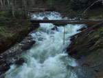
The road turns to dirt at Rapid River but is in great shape. It took us just over 2 hours to drive the 88 miles from Seattle. By 9:30 we were on the trail. We hurried to get ready as it was frigid at the trailhead. It could not have been much over 32 degrees but felt colder than that. The road used to go on to another trailhead but it now ends here as this is where the new Wild Sky Wilderness starts. The trail follows the NF Skykomish River a short distance to a high bridge over a narrow gorge. On the other side we saw the Wild Sky boundary sign.
Now the trail begins a series of long and short switchbacks. It is a horse trail and is seldom more than a ten percent grade. Easy on the knees and the lungs as it gains some 2300' in about 3 1/2 miles to the top of West Cady Ridge. This is old forest. No stumps here. Lots of huge trees. The trail has many small creek crossings. I suspect many of them are the same creeks. There are old puncheon bridges and rock hops. Even with higher than summer time water levels they were all easy enough to get across.
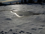
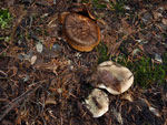
The devil's club has lost it's leaves and mushrooms are sprouting. It is much different than it looks in mid summer. There were no cars in the lot when we arrived and we saw zero people all day. There were recent footprints in the mud and snow though. In a few places the trail is a creek bed. These were not long but some trail work will be in order next year. Kim loves dark old growth forest and she somehow managed to keep her photo breaks to a minimum. We had only seven hours of daylight and wanted to have plenty of time on top.
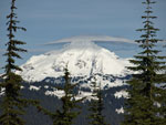
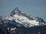
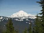
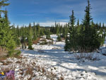
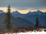
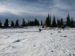
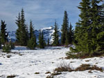
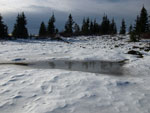
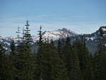
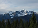
In due time we began to break out of the thick forest as we neared the ridge top. Views began to the west and northwest. Soon we could see out to Columbia and Kyes Peaks. They were very white with recent snow. As the grade lessened we began to intersect parts of the old trail. This one stayed more or less on the crest while the new one made a number of ever gentler switchbacks. Snow began where we left the deeper forest and soon blanketed the ground. It was never more than six inches deep. A break in the trees gave us a nice look at Glacier Peak. A little farther along we stopped for lunch.
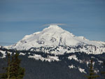
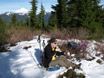
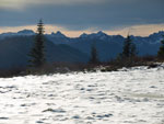
We had a great view to Glacier, Columbia, and Kyes Peaks. A few clouds began to drift in. It was cool on the snow but not at all cold. This was my first time here but Kim was able to marvel at the difference in just a few months since her earlier visit. The ridge top meadows were now snow fields. We had a nice long break before packing up. Kim mentioned a football field sized meadow and we wandered around looking for it. We did find it and had great views to the south from there. The top of Mt. Rainier was in the clear. The clouds were moving in faster which only added some nice lighting.
Many more photos ensued before we decided it was time to leave. On the way down we noticed that many switchbacks had sections of the old trail continuing on down. It did not look like the old trail was abandoned all that many years ago. It was fun searching for where it crossed over the new trail. The trail is so gentle for a 2300' gain that there was no knee pounding at all. A very easy descent. As we neared the river the temperature nosedived. At the bridge is was down right cold. In the parking lot it was colder still. Dew was on the car and fog was settling in.
The drive out was in and out of fog. It was dark before we reached Jack Pass. Fortunately the fog was gone as we reached Highway 2. The drive home was not bad at all. No Sunday night Sultan back up. This was a great trip. After 3400' of gain the day before I was glad to be on a gentle trail. It still did get us up to 5800' and terrific views of high snowy peaks. Finally, any sunny weekend day in November is better enjoyed in the mountains than in the city.
Kim has posted a report here: Nwhikers Report
Click on thumbnails to get larger pictures.
Photo Page 2
Trips - 2008
Home
The road turns to dirt at Rapid River but is in great shape. It took us just over 2 hours to drive the 88 miles from Seattle. By 9:30 we were on the trail. We hurried to get ready as it was frigid at the trailhead. It could not have been much over 32 degrees but felt colder than that. The road used to go on to another trailhead but it now ends here as this is where the new Wild Sky Wilderness starts. The trail follows the NF Skykomish River a short distance to a high bridge over a narrow gorge. On the other side we saw the Wild Sky boundary sign.
Now the trail begins a series of long and short switchbacks. It is a horse trail and is seldom more than a ten percent grade. Easy on the knees and the lungs as it gains some 2300' in about 3 1/2 miles to the top of West Cady Ridge. This is old forest. No stumps here. Lots of huge trees. The trail has many small creek crossings. I suspect many of them are the same creeks. There are old puncheon bridges and rock hops. Even with higher than summer time water levels they were all easy enough to get across.
The devil's club has lost it's leaves and mushrooms are sprouting. It is much different than it looks in mid summer. There were no cars in the lot when we arrived and we saw zero people all day. There were recent footprints in the mud and snow though. In a few places the trail is a creek bed. These were not long but some trail work will be in order next year. Kim loves dark old growth forest and she somehow managed to keep her photo breaks to a minimum. We had only seven hours of daylight and wanted to have plenty of time on top.
In due time we began to break out of the thick forest as we neared the ridge top. Views began to the west and northwest. Soon we could see out to Columbia and Kyes Peaks. They were very white with recent snow. As the grade lessened we began to intersect parts of the old trail. This one stayed more or less on the crest while the new one made a number of ever gentler switchbacks. Snow began where we left the deeper forest and soon blanketed the ground. It was never more than six inches deep. A break in the trees gave us a nice look at Glacier Peak. A little farther along we stopped for lunch.
We had a great view to Glacier, Columbia, and Kyes Peaks. A few clouds began to drift in. It was cool on the snow but not at all cold. This was my first time here but Kim was able to marvel at the difference in just a few months since her earlier visit. The ridge top meadows were now snow fields. We had a nice long break before packing up. Kim mentioned a football field sized meadow and we wandered around looking for it. We did find it and had great views to the south from there. The top of Mt. Rainier was in the clear. The clouds were moving in faster which only added some nice lighting.
Many more photos ensued before we decided it was time to leave. On the way down we noticed that many switchbacks had sections of the old trail continuing on down. It did not look like the old trail was abandoned all that many years ago. It was fun searching for where it crossed over the new trail. The trail is so gentle for a 2300' gain that there was no knee pounding at all. A very easy descent. As we neared the river the temperature nosedived. At the bridge is was down right cold. In the parking lot it was colder still. Dew was on the car and fog was settling in.
The drive out was in and out of fog. It was dark before we reached Jack Pass. Fortunately the fog was gone as we reached Highway 2. The drive home was not bad at all. No Sunday night Sultan back up. This was a great trip. After 3400' of gain the day before I was glad to be on a gentle trail. It still did get us up to 5800' and terrific views of high snowy peaks. Finally, any sunny weekend day in November is better enjoyed in the mountains than in the city.
Kim has posted a report here: Nwhikers Report
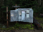 Trailhead Sign |
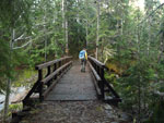 Bridge Over Skykomish |
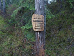 Wild Sky Boundary |
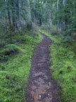 Moss Lined Trail |
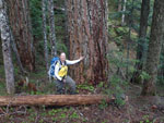 Kim & Big Tree |
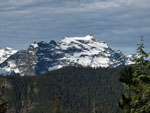 Kyes Peak |
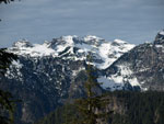 Columbia Peak |
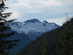 Mystery Mountain |
 Lenticular Over Glacier |
 Sloan Peak |
 Almost Clear |
 Lunch Time |
 Glacier In The Clear |
 West Cady Ridge Top |
 Clouds Coming In |
 Snow Patterns |
 View South |
 Big Meadow |
 Framed Kyes |
 Reflection |
 Darkening |
 Indian Head Peak |
 Monte Cristo Peaks |
 Mushrooms |
 NF Sky At Dusk |
Photo Page 2
Trips - 2008
Home