7/17-18/10
I had not been
out backpacking since February. Bob and Kolleen mentioned they planned
a trip up West Cady Ridge to Benchmark Mountain. I had been up far
enough to see some terrific views on West Cady Ridge on 11-16-08
but wanted to continue on to Benchmark. Camping on or near the summit
would be even better. We drove up Highway 2 to Beckler River then over
Jack's Pass and down to the Skykomish River. A right turn brought us to
the road end trailhead. There was a big group getting ready to go and
we headed out ahead of them at 10:12 am.
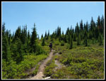
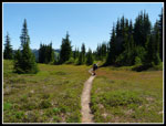
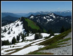
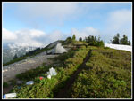
The route begins at a steady gentle grade gaining 1800' in 3 miles to the beginning of the ridge. Views begin here and never really let up. Either out to peaks or around to the miles of meadows. The trail is in fine shape. We had one log to crawl under and one to step over on the way up and both were gone on the way down. Over cast skies in Seattle gave way to blue sky in the mountains. We stopped at 3 miles for a food break. It was getting a little hot.
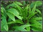
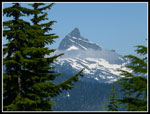
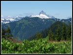
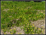
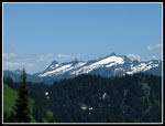
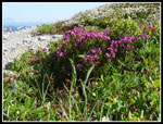
Bugs were annoying at the trailhead but much less of a problem up higher. Snow is melting fast. We saw the first patches at about 4500'. Most were short. There is still some longer patches farther along the ridge but none caused any problems. The first views were back wet towards Baring, Gunn, etc. Kyes soon came into view and then Glacier Peak. Not a lot of flowers out yet. We saw many bunchberry along the trail. Just a few bleeding hearts, columbine, and queens cup in the forest.
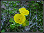
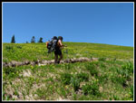
We passed one day hiker. The big group did not catch us. There are several ups and downs along the ridge. Not too bad overall. The trailhead is at 2500' and the summit is 5816'. We kept moving at a steady pace though photos did slow us down. Dropping down from the last bump we found more snow and the beginning or fields of glacier lilies. They were as thick as I have ever seen. We saw a camp at the low point but chose to continue on.
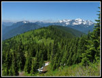
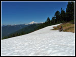
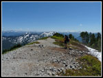
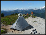
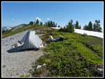
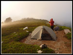
Climbing up with all the glacier lilies slowed us considerably. At a trail junction we went left a short way to find a large campsite. This was only a few hundred feet below the summit and has trees for shelter and very nice views. We decided not to stop here. Instead we climbed to the summit hopeful of finding space for two tents. Although there is snow on parts of the trail up it is easy to follow the ridge to the top. It was almost 2:30 when we reached the summit. There was maybe one tent spot. I dropped my pack and headed down the ridge. Benchmark Mountain is a ridge with a slightly higher spot in the center. The path continues past the top staying right on the crest. Just west of the crest there is still snow. No problem finding water.
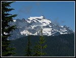
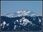
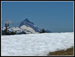
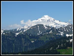
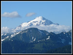
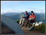
I found a square cut out spot on the crest. Another spot on rocky dirt was not totally flat but would work for one more tent. I went back to the summit and we all went to the sites. Bob and Kolleen took the larger spot for their Tarptent Double Rainbow. I brought me Tarptent Rainbow. We had camp set up quickly. With nearly 7 hours of daylight left we sat down to relax. Fantastic views from the summit. The Pacific Crest Trail is just a ridge over to the east. Skykomish Peak was close by. Kyes is to the northwest then Sloan, Bedal, Pugh, Baker, Glacier, and so many more. Even Mt. Rainier was out to the south along with Stuart, Daniel, and Hinman.
I found a big tree below the ridge to hang food. Bob was busy melting snow for dinner and drinking water. The high was forecast to be in the low 60s at that elevation but it was much warmer. With no shade the snow was the only way to keep cool. This problem was not indefinite. After dinner clouds began to come in. We heard voices and saw three hikers below to the east. Turns out they were nwhikers. We hollered and they came up to visit. They took the first big campsite and were out for a little more hiking. After that we saw a hiker on the summit. He came to visit. Tag Man is also an nwhiker. He was in the 8 person group from Bremerton that we had seen at the trailhead. They took the campsite a few hundred feet below the summit.
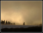
After they left we were along on top. The wind began to pick up and made it less comfortable to stay out of the tents. Not a great sunset though the clouds were turned a little orange as the sun set. By 9:00 we headed indoors. The wind was much stronger than forecast. It was a steady 10 mph with gust to maybe 20+ mph. The ground was very soft where my tent sat. I placed big rocks over the stakes as they did not stick well. I figured I would be fine.
At about 11:30 two stakes gave way. The tent was flapping and woke me up before the collapse. My Rainbow turned into a Rainbivy. The pole still give me a foot of headroom. I could get dressed and head out to try to set it back up and have the flapping or I could do nothing. Nothing won. It worked pretty well. At 5:30 am I did get up and saw a 10 lb. rock had been moved by the wind to allow the collapse. I placed an even bigger rock and went back to bed.
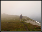
It was mid winter when we climbed out of our tents with puffy layers, and raincoats on. Felt like February not mid July. We broke camp at 8:45 and the wind wind died down a little earlier. Total cloud cover at 5:30 slowly broke and we had nice views before heading down. Sun on top of some clouds was great to photograph. As we dropped off the summit and went over the next high point we dropped back into some clouds. We met one group of dayhikers on the ridge and a few others on the lower trail. Not very many folks on the route all weekend.
It was a great weekend. Sun and heat followed by clouds and cool. Miles of great meadows. Whole slopes of glacier lilies in full bloom. It was great to camp on the summit and see what we had of a sunset and sunrise. It was a relaxing weekend as we had a long stay on the summit. Nice to get out with Bob and Kolleen again and nice to get in a backpacking trip. West Cady Ridge is a great meadow walk and the summit of Benchmark has some amazing views. I will be back.
Bob and Kolleen have posted photos here: Nwhkers Report & Photos
Click on thumbnails to get larger pictures.
Photo Page 2
Trips - 2010
Home
The route begins at a steady gentle grade gaining 1800' in 3 miles to the beginning of the ridge. Views begin here and never really let up. Either out to peaks or around to the miles of meadows. The trail is in fine shape. We had one log to crawl under and one to step over on the way up and both were gone on the way down. Over cast skies in Seattle gave way to blue sky in the mountains. We stopped at 3 miles for a food break. It was getting a little hot.
Bugs were annoying at the trailhead but much less of a problem up higher. Snow is melting fast. We saw the first patches at about 4500'. Most were short. There is still some longer patches farther along the ridge but none caused any problems. The first views were back wet towards Baring, Gunn, etc. Kyes soon came into view and then Glacier Peak. Not a lot of flowers out yet. We saw many bunchberry along the trail. Just a few bleeding hearts, columbine, and queens cup in the forest.
We passed one day hiker. The big group did not catch us. There are several ups and downs along the ridge. Not too bad overall. The trailhead is at 2500' and the summit is 5816'. We kept moving at a steady pace though photos did slow us down. Dropping down from the last bump we found more snow and the beginning or fields of glacier lilies. They were as thick as I have ever seen. We saw a camp at the low point but chose to continue on.
Climbing up with all the glacier lilies slowed us considerably. At a trail junction we went left a short way to find a large campsite. This was only a few hundred feet below the summit and has trees for shelter and very nice views. We decided not to stop here. Instead we climbed to the summit hopeful of finding space for two tents. Although there is snow on parts of the trail up it is easy to follow the ridge to the top. It was almost 2:30 when we reached the summit. There was maybe one tent spot. I dropped my pack and headed down the ridge. Benchmark Mountain is a ridge with a slightly higher spot in the center. The path continues past the top staying right on the crest. Just west of the crest there is still snow. No problem finding water.
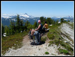
I found a square cut out spot on the crest. Another spot on rocky dirt was not totally flat but would work for one more tent. I went back to the summit and we all went to the sites. Bob and Kolleen took the larger spot for their Tarptent Double Rainbow. I brought me Tarptent Rainbow. We had camp set up quickly. With nearly 7 hours of daylight left we sat down to relax. Fantastic views from the summit. The Pacific Crest Trail is just a ridge over to the east. Skykomish Peak was close by. Kyes is to the northwest then Sloan, Bedal, Pugh, Baker, Glacier, and so many more. Even Mt. Rainier was out to the south along with Stuart, Daniel, and Hinman.
I found a big tree below the ridge to hang food. Bob was busy melting snow for dinner and drinking water. The high was forecast to be in the low 60s at that elevation but it was much warmer. With no shade the snow was the only way to keep cool. This problem was not indefinite. After dinner clouds began to come in. We heard voices and saw three hikers below to the east. Turns out they were nwhikers. We hollered and they came up to visit. They took the first big campsite and were out for a little more hiking. After that we saw a hiker on the summit. He came to visit. Tag Man is also an nwhiker. He was in the 8 person group from Bremerton that we had seen at the trailhead. They took the campsite a few hundred feet below the summit.
After they left we were along on top. The wind began to pick up and made it less comfortable to stay out of the tents. Not a great sunset though the clouds were turned a little orange as the sun set. By 9:00 we headed indoors. The wind was much stronger than forecast. It was a steady 10 mph with gust to maybe 20+ mph. The ground was very soft where my tent sat. I placed big rocks over the stakes as they did not stick well. I figured I would be fine.
At about 11:30 two stakes gave way. The tent was flapping and woke me up before the collapse. My Rainbow turned into a Rainbivy. The pole still give me a foot of headroom. I could get dressed and head out to try to set it back up and have the flapping or I could do nothing. Nothing won. It worked pretty well. At 5:30 am I did get up and saw a 10 lb. rock had been moved by the wind to allow the collapse. I placed an even bigger rock and went back to bed.
It was mid winter when we climbed out of our tents with puffy layers, and raincoats on. Felt like February not mid July. We broke camp at 8:45 and the wind wind died down a little earlier. Total cloud cover at 5:30 slowly broke and we had nice views before heading down. Sun on top of some clouds was great to photograph. As we dropped off the summit and went over the next high point we dropped back into some clouds. We met one group of dayhikers on the ridge and a few others on the lower trail. Not very many folks on the route all weekend.
It was a great weekend. Sun and heat followed by clouds and cool. Miles of great meadows. Whole slopes of glacier lilies in full bloom. It was great to camp on the summit and see what we had of a sunset and sunrise. It was a relaxing weekend as we had a long stay on the summit. Nice to get out with Bob and Kolleen again and nice to get in a backpacking trip. West Cady Ridge is a great meadow walk and the summit of Benchmark has some amazing views. I will be back.
Bob and Kolleen have posted photos here: Nwhkers Report & Photos
 Shades Of Green |
 First Kyes Peak View |
 Miles Of Meadows |
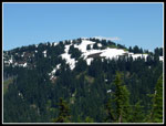
 Sloan Peak |
 Meadow & Benchmark |
 Meadows Below |
 Mt. Daniel |
 Meadows & Sloan |
 First Glacier Lilies |
 Buttercups |
 Snow On Trail |
 Summit Of Benchmark Mt. |
 Poets Ridge |
 Thick With Glacier Lilies |
 Kolleen On Trail |
 Sloan Over Snow |
 Benchmark Summit |
 White Meets Green |
 Glacier Peak |
 Bob & Kolleen On Summit |
 Fly By |
 Summit Camp |
 Summit Heather |
 Snooze Time |
 Clouds Around Glacier |
 Clouds Begin To Appear |
 Bundled Up |
 Lost In The Clouds |
 Evening Clouds |
 Icy Cold Wind |
Photo Page 2
Trips - 2010
Home